Proceedings of EARSeL-SIG-Workshop Land Ice and Snow, Dresden/FRG, June 16 – 17, 2000
DIGITAL AND AUTOMATED HIGH RESOLUTION STEREO MAPPING OF THE SONNBLICK GLACIER (AUSTRIA) WITH HRSC-A E. Hauber1, H. Slupetzky2, R. Jaumann1, F. Wewel1, K. Gwinner1, G. Neukum1 1) German Aerospace Center, Institute of Space Sensor Technology and Planetary Exploration, 12484 Berlin, Germany, phone: +49.30.67055.325, fax: +49.30.67055.402, email:
[email protected] 2) Institute of Geography and Applied Geoinformation, University Salzburg, Salzburg, Austria. ABSTRACT The airborne High Resolution Stereo Camera (HRSC-A) is a multiple line scanner which simultaneously acquires stereo and colour information with absolute spatial accuracy in the decimetre range. The multiple stereo principle is particularly well suited for obtaining precise topographic and imaging data of rugged terrain as found in mountainous regions: a permanently nadir-looking stereo channel provides favourable visibility conditions even for steep slopes and minimises the occurrence of shadow zones which affect the performance of side-looking sensor systems such as SAR. A sophisticated and fully automated photogrammetric processing system allows to determine topography even in areas which are problematic for image correlation techniques needed to extract height information from stereo imagery, e.g. in areas with low texture information like snow. In order to supplement existing monitoring techniques for snow and ice-covered regions, HRSC-A was used in a pilot study to map an area of the Hohe Tauern mountain range in Austria enclosing some of the most intensively analysed glaciers in the Alps. The results are of outstanding quality and suggest the future application of HRSC-A for the remote sensing of snow and ice, particularly in the context of climate-related studies. INTRODUCTION The Stubacher Sonnblickkees (Hohe Tauern, Austria) is one of the most intensively monitored glaciers in the Eastern Alps (Slupetzky and Aschenbrenner 1998). Its length has been measured for 40 years, and its mass balance has been determined since 1963. Moreover, the water budget in the area is monitored within the drainage area of an artificial reservoir. Mass balance monitoring is focused on the understanding of climate-glacier interactions. It is part of the International Hydrologic Program (IHP) of UNESCO and represents a contribution to the Global Environment Monitoring System (GEMS) of UNEP. Since glaciers are sensitive climate indicators, continuous long-term monitoring is increasingly important for the interpretation of global changes. Regular mapping is essential to provide quantitative results and to allow for trend extrapolation. Here, we address the challenge of fully automated and digital airborne mapping of glaciers in an alpine environment. METHODS Instrument: The High Resolution Stereo Camera (HRSC) has originally been designed for space applications and will be flown onboard the ESA Mars Express mission in 2003 (Neukum and Tarnopolsky 1990; Albertz et al. 1992; Neukum et al. 1999). An airborne version of this camera (HRSC-A) has been applied successfully in many flight campaigns (Neukum 1999), including 3Dimage data provision for volcanology, agriculture, forestry, open coal mining and mapping of urban areas. Pilot experiments on active volcanoes have previously demonstrated the potential of the camera system for mapping rugged terrain (Gwinner et al. 1999). The sensor system is based on the along-track multiple-stereo pushbroom principle (see Figure 1), meets all requirements of a photogrammetric sensor, and combines 3D-capabilities and high spatial EARSeL eProceedings No. 1
246
Proceedings of EARSeL-SIG-Workshop Land Ice and Snow, Dresden/FRG, June 16 – 17, 2000
resolution with multi-spectral data acquisition (Table 1). Nine CCD lines in the focal plane behind one single optics are precisely calibrated to allow for high geometric accuracy. Four lines are equipped with spectral filters (IR, Gr, Bl, Rd in Fig. 1). The unique multi-stereo functionality is based on the other five lines (SA, PA, Nd, PF, SF), providing panchromatic data with specific viewing angles. Variable resolutions can be generated, resulting in ground pixel sizes as small as 10 cm from an altitude of 2500 m. During flight operation, the camera is mounted on a stabilised platform in order to damp mechanical vibrations and to enforce near-nadir viewing geometry. An integrated GPS/INS navigation system (APPLANIX POS/DG, see Hutton and Lithopoulos 1998) including a GPS receiver and a strap-down INS is used to obtain high accuracy measurements of the exterior sensor orientation.
Figure 1. Imaging Principle of HRSC-A Photogrammetric Processing: A digital photogrammetric processing system was developed for the HRSC experiment on the Mars96 mission in co-operation with the Technical University of Berlin. An automated procedural software system has been derived for the airborne operation of HRSC-A (Figure 2). The photogrammetric processing line makes use of a set of systematically preprocessed image, orientation and calibration data. Since the Inertial Measurement Unit (IMU) cannot be mounted exactly parallel to the HRSC-A camera axes, the offset between both systems has to be computed. This computation can be done without any additional ground control information, since HRSC-A provides sufficient multi-stereo image information. HRSC-A/QM Technical Parameters Focal Length: 175 mm Total Field of View: 37.8° x 11.8° Number of CCD Lines: 9 Stereo Angles: ±18.9° and ±12.8° Pixels per CCD Line: 5184 (active) Pixel Size: 7 µm Radiometric Resolution: 10 bit reduced to 8 bit Read-Out Frequency: 450 lines/s Mass: 12 kg (32 kg including subsystems) Table 1.
Technical Parameters of HRSC-A
Image data of a pushbroom system like HRSC-A are influenced by the continuously changing exterior orientation. Applying image matching techniques for the generation of Digital Elevation ModEARSeL eProceedings No. 1
247
Proceedings of EARSeL-SIG-Workshop Land Ice and Snow, Dresden/FRG, June 16 – 17, 2000
els (DEM) to the original image data would result in failures, since the matching algorithm would match not only textures but also flight motion effects, especially when they appear periodically. To avoid these failures, the HRSC-A data of all five stereo sensors are pre-corrected by rectifying them to a mean terrain level based on the data of the exterior orientation. Figure 3 shows the potential of the rectification process and the quality of the GPS/INS data, even under extreme conditions during a flight manoeuvre. The permanent nadir viewing geometry of HRSC-A makes the nadir channel the most appropriate master image. It guarantees the best possible coverage (with respect to completeness) because of the reduction of hidden areas. In order to reduce the influence of matching failures and to introduce redundancies, the nadir grid points should not be matched with only one partner but with all (four) possible stereo partners. Thus, the multi-stereo capability of HRSC-A provides the possibility to determine points with up to five observations and to eliminate errors. HRSC-A Image Data, Calibration Data, D-GPS & INS Data Installation Offset between HRSC-A and IMU
Simultaneous Determination of Position and Attitude
Orientation Data for each Image Line Geometric Correction of Image Data
Image Matching
Orthoimage Generation
DEM Generation
Colour Orthomosaics Orthoimage Mosaics
DEM Follow-Up Products
Figure 2. HRSC-A Photogrammetric Processing Line
Figure 3. Effectiveness of geometric correction under extreme conditions. Original HRSC-A data (lower left), pre-rectified image data (centre) and enlargement of pre-rectified image (upper right). Flight altitude was 3000 m, ground resolution 15 cm (note that the white lines of a tennis court are quite visible in the enlargement). Together with information about the interior and exterior orientation each set of image co-ordinates of a match point includes up to five rays. The intersection of these rays and the quality of intersection is computed within a least-squares adjustment process. Points defined by less than three rays EARSeL eProceedings No. 1
248
Proceedings of EARSeL-SIG-Workshop Land Ice and Snow, Dresden/FRG, June 16 – 17, 2000
are eliminated due to the lack of redundancy. The remaining set of object points is defined in the GPS/INS reference system (WGS84) and can be transformed to other geodetic datum, depending on the intended cartographic representation of the final raster DEM. The DEM, represented in any requested map projection, can now be interpolated from the set of object points. It can be used for the extraction of profiles, contour lines or other DEM follow-up products and is the basic prerequisite for the subsequent generation of orthoimages. During orthoimage generation, rays defined by the calibration and the orientation data of each pixel are intersected with the surface described by the DEM. The final step within the photogrammetric data processing is the generation of orthoimage mosaics using orthoimages of adjacent strips. The result is a homogeneous image mosaic for each spectral band, represented in the requested map projection. Potential of the HRSC-A for Cartographic Applications: Based on the digital concept of the camera and its associated digital photogrammetric processing line, the HRSC-A system enables various cartographic applications. On the one hand, different map scales can be derived with appropriate accuracy. However, not only high-resolution and highly-accurate data are the main advantages of the system, the multi-spectral image data can also be used directly for various thematic representations, especially combined with the 3D-capabilities of the system. Table 2 gives an overview of the ground resolution and accuracy of HRSC-A image and 3D-data and the resulting capabilities for different map scales. If high-resolution panchromatic data are merged with multi-spectral data (e.g. by using HSI-color transformation), the resulting data set includes both high resolution and multispectral information and can be used for nearly the same map scales as given for panchromatic data in Table 2. Flight Altitude
Ground Resolution panchromatic / multi-spectral
Planimetric Accuracy
Height Accuracy
1500 m
0.12 m / 0.35 m
0.10 m
0.15 m
3000 m
0.15 m / 0.40 m
0.15 m
0.20 m
= 1: 750 / = 1: 2000
6000 m
0.20 m / 0.45 m
0.30 m
0.40 m
= 1: 1.500 / = 1: 3500
Table 2.
Appropriate Map Scales panchromatic / multi-spectral = 1: 500 / = 1: 1500
Resolution, Accuracy, and Cartographic Capabilities of HRSC-A Image Data
The completely digital and highly automated imaging and processing line enables the unique derivation of high-resolution and multi-spectral image and 3D-data, combined with short processing periods. Even project areas of several hundred square-kilometres can be processed within a few weeks, yielding products such as colour orthoimage mosaics and Digital Elevation Models. Thus, not only large-scale applications but also mapping at medium scales (e.g. 1: 10,000 to 1: 25,000) can be performed. RESULTS Imaging Parameters: The Sonnblickkees flight campaign took place in late summer (September 14th, 1999), when snow coverage on the glacier is at its yearly minimum. This is the most convenient season for remote sensing of glaciers, since a) the volume measurements are not biased by snow coverage, and b) the glacier surface provides a maximum of texture which is important for automatic correlation of the stereo images. Within the period of 3 hours about 40 Gbyte of stereo and multispectral data were acquired on more than 20 image tracks, covering about 100 km2 centred at 12°38'E, 40°07'N approximately. The flight altitude was 5800 m a.s.l. or 3000 m above mean ground level, yielding mean ground pixel sizes of 14 cm. Due to the variations in elevation of 2000 m the ground pixel sizes varied from 10 cm to 18 cm across-track. Flight speed of approximately 260 km/h and the camera integration time of 2.24 ms for the nadir channel and 4.48 ms for the stereo channels yields ground pixel resoEARSeL eProceedings No. 1
249
Proceedings of EARSeL-SIG-Workshop Land Ice and Snow, Dresden/FRG, June 16 – 17, 2000
lutions of 16 cm and 32 cm in flight direction. Figure 4 shows the orthoimage of a part of the whole processed area (Fig. 5) and demonstrates the high lateral and vertical resolution as well as the radiometric properties of the data. In order to get high accuracy position data of the sensor differential GPS is essential. Since there was no reference receiver operating close to the area, the GPS receiver of the Bavarian SAPOS station Rosenheim (distance about 110 km) was used. Because of the long distance from the airport to the glacier area, an in-flight alignment of the INS involving a flight manoeuvre with accelerations in all directions was performed.
Figure 4. HRSC-A nadir orthoimage of large parts of the Sonnblick glacier. Contour interval is 20m. Geometric Accuracy: In order to determine the relationship between the GPS/INS measurements and the HRSC-A camera co-ordinate system (boresight offset), ray intersection of identical points of adjacent image strips is optimised in an iterative process. Within this process the relative and the absolute accuracy can be estimated simultaneously. 600 conjugate points matched automatically in the five stereo images of each single image strip and 200 identical points matched in adjacent and in two crossing strips were used to evaluate the accuracy of the Sonnenblickkees campaign. The relative point accuracy determined by spatial intersection of the conjugate rays of the five HRSC-A stereo channels is ±17 cm. The absolute accuracy, derived from the standard deviation of all the object points measured in adjacent image strips is ± 18 cm for planimetry and ± 21 cm for height. Within the time frame of three hours no systematic drift effects of the INS system occurred. These results are in accordance with several test flight evaluations performed previously (see Wewel and Brand, 1999). These tests have shown the high potential of the entire camera system. By means of more than one hundred check points the mean absolute deviation was evaluated to within about ± 12 cm for planimetry and ± 17 cm for height. The slightly less accurate results for the Sonnblickkees campaign can be attributed to the long distance (110 km) of the static GPS reference sensor from the target area.
EARSeL eProceedings No. 1
250
Proceedings of EARSeL-SIG-Workshop Land Ice and Snow, Dresden/FRG, June 16 – 17, 2000
Figure 5. Shaded relief map of total area of flight campaign. White boxes outline areas of figure 4 (A) and 6 and 7 (B). Area is about 15 x 7,5 km (>100 km2); North is up. EARSeL eProceedings No. 1
251
Proceedings of EARSeL-SIG-Workshop Land Ice and Snow, Dresden/FRG, June 16 – 17, 2000
The basic reference system for HRSC-A data is the global reference system WGS84. If formal datum shift parameters to this reference frame are available, the data products can be transformed to any other reference system without any further input. Due to the lack of consistent parameters for the transformation of the WGS84 co-ordinates to the local Austrian reference system (MGI), ground control points have to be used to derive the geodetic datum shift parameters. Data Products: Since the end-to-end data flow of HRSC-A data is highly automated and fully digital throughout the entire processing sequence, the generation of final data products and derived thematic maps is fast and straightforward. The basic photogrammetric data products are Digital Elevation Models (DEM) and corresponding orthoimages. Thematic maps can then be generated from these base data, again in digital form and without costly and time-consuming intermediate steps such as digitising.
Figure 6. Three-dimensional perspective view of Sonnblickkees and Rudolfshütte in the Hohe Tauern mountain range (Austria) as derived from DEM and orthoimage. View is from Northeast. Three-dimensional or perspective views can be easily generated based on the combination of orthoimage and DEM. Such data are especially well suited for a quick visualisation of 3D-terrain characteristics combined with image or thematic information (Fig. 6). The digital format of all HRSC-A products is also ideal for other applications like streamlined integration and combination of raster data from HRSC-A and vector data from Geographic Information Systems (GIS), quick data dissemination via Internet, and interactive and multi-media-oriented data visualisation.
EARSeL eProceedings No. 1
252
Proceedings of EARSeL-SIG-Workshop Land Ice and Snow, Dresden/FRG, June 16 – 17, 2000
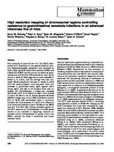
Important parameters for many applications in mountainous areas are aspect and slope of the surface. The aspect is the orientation of the surface normal with respect to North (the direction in which water would flow when dropped on the surface), and the slope is given by its zenith angle. For example, snow avalanches start preferentially on steep slopes (>30°) in the lee of ridges (where most of the snow blown off the wind-ward mountain face is deposited). Together with the knowledge of wind directions prevailing during and shortly after heavy snowfall, maps of aspect and slope (Fig. 7) can thus help skiers to find safe tracks. CONCLUSIONS The results of this pilot study confirm the capability of HRSC-A to provide high resolution topographic and imaging data of snow and ice regions with decimetre accuracy. The fast and fully digital end-to-end data flow from raw data to Digital Elevation Models (DEM) and orthoimages makes the instrument particularly well suited for regular and repeated monitoring campaigns which often suffer from long periods between data acquisition and the generation of final data products. An immediate application for HRSC-A in high mountain terrain is to support techniques for long-term monitoring of snow and ice in climate studies, providing laterally extensive data sets with resolutions intermediate between ground-based point measurements (GPS) and satellite-based low resolution data. Other potential mountain-related fields which will benefit from HRSC-A data include the support of water and reservoir management by providing detailed snow melting patterns in specific catchment areas. The economically important hazard mitigation, i.e. the investigation of slopes subject to gravity driven mass wasting (avalanches, landslides) as well as the management and monitoring of protection forests are further promising applications for HRSC-A.
Figure 7. Colour-coded aspect map (left), orthoimage merged with colour-coded slope map (right). EARSeL eProceedings No. 1
253
Proceedings of EARSeL-SIG-Workshop Land Ice and Snow, Dresden/FRG, June 16 – 17, 2000
ACKNOWLEDGEMENTS We thank the HRSC-A team and in particular Frank Scholten, Thomas Roatsch, Sergej Sujew, and Joachim Flohrer for their support in processing the image data used in this study. An anonymous reviewer helped to improve the text. REFERENCES Albertz, J. et al. 1992. The Camera Experiments HRSC and WAOSS on the Mars '94 Mission. Int. Archives of Photogrammetry and Remote Sensing, Washington D.C., USA, Vol. XXIX, Part B1: 130-137. Gwinner, K. et al. 1999. The HRSC–A Experiment on High Resolution Multispectral Imaging and DEM Generation at the Aeolian Islands. Proceedings of 13th Int. Conf. on Applied Geologic Remote Sensing, Vancouver, Canada, Vol. I: 560-569. Hutton, J. and Lithopoulos E. 1998. Airborne Photogrammetry using Direct Camera Orientation Measurements. Neukum G. and Tarnopolsky V. 1990. Planetary Mapping – The Mars Cartographic Data Base and a Cooperative Camera Project for 1994. Geo-Informationssysteme. 3, (H2): 20-29. Neukum, G. and the HRSC Co-Investigator and Experiment Team 1999. The High Resolution Stereo Camera (HRSC) onboard the European Mars Express Mission. ESA, 12 p. (in press). Neukum, G. 1999. The Airborne HRSC-A: Performance Results and Application Potential. Photogrammetric Week, Stuttgart: 83-88. Slupetzky, H. and Aschenbrenner, J. 1998. Stubacher Sonnblickkees, Hohe Riffel, and Alpinzentrum Rudolfshütte, Austria, 1: 5.000 (Three Image Line Maps). Fluctuations of Glaciers (19901995), Vol. VII, World Glacier Mo-nitoring Service (WGMS) of the IUGG-FAGS/ICSI. Publ. by the ICSI of the IAHS and UNESCO, Paris, p. 73 Wewel, F. and Brand, M. 1999. Geometrische Validierung des hochauflösenden multispektralen MehrzeilenStereoscanners HRSC-A. Publ. Deutsche Gesellschaft f. Photogrammetrie u. Fernerkundung, Berlin, Vol. 7: 245-252.
EARSeL eProceedings No. 1
254