Traffic Status Monitoring Using Smart Devices Koustabh Dolui, Srijani Mukherjee
Soumya Kanti Datta
Electronics and Communications St. Thomas’ College of Engineering and Technology Kolkata, India {doluikoustabh, mukherjeesrijani}@gmail.com
Mobile Communication Department, EURECOM Sophia Antipolis, France
[email protected]
Abstract— This paper presents a system to determine the status of traffic of a particular region from real time data accumulated from smartphones. The data collection, interpretation and dissemination of the status to multiple users are performed remotely. We have used embedded sensors available in smartphones to gather data from traffic instead of deploying sensor modules. This method reduces the overall cost since smartphones are equipped with mobile data connection, precise sensors, high processing power and widely adopted by users. The methods of measurement of vehicular speed and distance traversed using the inbuilt GPS sensor, are discussed in detail. We have defined the parameters based on which the status of the traffic can be judged and how these parameters are related to vehicular distance and speed. Along with these, we have a proposed a client-server architecture for dissemination of data from the smartphone to the server and vice versa. The client is an application running on the smartphones. We have also proposed advanced methods of data accumulation and dissemination for modern vehicles with improved facilities and infrastructure. The entire system is developed in Android since it is open source in nature, widely used and application development is relatively easy. Keywords— traffic status; Android; smart device; GPS data; accelerometer; road status; client server communication model.
I.
INTRODUCTION
Road traffic has always been a major subject of research and now even more so with the increasing complexity of traffic and the steep rise in cars. Congestion in road traffic is a common phenomenon worldwide. Many preventive measures have been implemented in the past in the form of dedicated sensor modules, traffic analysis using cameras and with the use of piezoelectric sensors [1] as well. In the recent past, Transport for London has developed a real time traffic management system based on analysis of data from embedded sensors in the roads and data from video cameras. Research in traffic congestion also led to development of Intelligent Transportation Systems, with added context aware sensor modules in vehicles [2]. These modules require high amount of monetary investment and quality infrastructure. They are not quite feasible for implementation in developing countries due to lack of proper infrastructure and unavailability of high bandwidth internet. This led to the development of Nericell [3], which used smartphones to gather traffic data from their inbuilt sensors. The process involved use of the accelerometer to monitor road
condition (presence of potholes and bumps). This data was analyzed and used to determine the condition of road traffic. Mechanisms for gathering road traffic data from smartphones have been addressed in existing literature [4], including work of road surface monitoring using Android smartphones [5]. In this paper we are focusing on a holistic approach in determining the status of traffic with the analysis of various parameters. A. Smartphone Sensor Network The data collected from the GPS sensor of an Android smartphone includes the co-ordinates of the position of the mobile phone along with the time at which the data is collected. Using this data from the sensor we have calculated the speed of the vehicle at a particular instant. The data from multiple smartphones are accumulated and are stored in the server. The values are stored corresponding to particular regions defined in the database. The smartphone network is connected to the server over internet through Wi-Fi, 2G, GPRS, EDGE, UMTS or 4G connectivity. B. Client Server Architecture The entire area covered by the smartphone networks is divided into multiple rectangular regions (R i ; i=1, 2, 3,…) based on important places, street names and landmarks. A region R i is defined by a set of boundary co-ordinates, (A x ,A y ), (B x , B y ), (A x, B y ), (B x , A y ); [(A x >B x ), (A y >B y )] For a particular input from a smartphone the co-ordinates are given by (C x , C y ). If (A x >C x >B x )&(A y >C y >B y ), then (C x ,C y ) belongs to R i , as represented in Fig. 1.
Fig. 1. A sample region R i with boundary co-ordinates
When another smartphone requests the server for the status of a particular region R j , the server acknowledges this request from the client. Following the acknowledgement, the server searches for the status of the requested region and disseminates it to the client user. Depending on the status of the requested region the user opts for the best path to reach the destination. Fig. 2 presents the Client-Server model for accumulation and dissemination of traffic data.
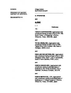
have presented a graph, in which we have plotted the cumulative speeds measured considering the following equation (2) for values of j=1, 2,3,4,5 at any instant (i). 𝑆𝑐𝑢𝑚 (𝑖) = Speed (km/h)
The server stores the data in the location reserved for Region R i . The server then carries out analysis of the data collected for the region (discussed later in Section III). It determines the status of the traffic from the analysis for a particular region and stores the status for that region.
𝑘=𝑖−𝑗
∑𝑘=𝑖
𝑉𝑖𝑛𝑠(𝑖)
(2)
𝑗+1
12 10 8 6 4 2 0 2
4
6
8
10
Time elapsed(seconds) j=0 Fig. 3.
The GPS sensor from the smartphone provides the coordinates for the location of the phone and the timestamp for the location. We can measure various parameters required to determine the traffic status from the above data. A. Speed Measurement of Vehicle The distance traversed between two time instances can be used to measure the instantaneous speed of the vehicle. We can measure the speed in two forms: 1) Instantaneous Speed 2) Cumulative Speed If the location at instant t i be given by (X i , Y i ) and for instant t i+1 be given by (X i+1 , Y i+1 ), the instantaneous speed is defined by S ins , mentioned in eq. (1) �(𝑋𝑖+1 −𝑋𝑖 )2 +(𝑌𝑖+1 −𝑌𝑖 )2 𝑡𝑖+1 −𝑡𝑖
j=3
j=4
Graph for cumulative speeds for different values of j
The instant acceleration between 2 time instants can be calculated from the instant speed and is given by eq. 3.
MEASUREMENTS FROM SENSORS
𝑆𝑖𝑛𝑠 (𝑖) =
j=2
From the graph we can deduce that if only instantaneous speed is considered for j=0, we acquire unnecessary positive and negative spikes in measuring the cumulative speed pertaining to abrupt acceleration and braking. The cumulative speed is most accurate for j=3 as we can conclude from the graph.
Fig. 2. Client Server model for data accumulation and dissemination
II.
j=1
(1)
This can be used to detect the acceleration and retardation of the cars at the particular instants. If this data is coupled with data obtained from the accelerometer, we can detect whether the braking or retardation is due to a pothole/bumper or a result of impending traffic congestion. Even though the instantaneous speed is sufficient to detect the traffic scenario, it is not accurate to be considered as the actual speed of the vehicle at that point of time. In Fig. 3 we
𝐴𝑖𝑛𝑠 (𝑖) =
𝑉𝑖+1 −𝑉𝑖 𝑡𝑖+1 −𝑡𝑖
(3)
B. Determination of Direction of Movement The direction of movement can be determined from the coordinates received at two time instances. The latitudes north of the equator is measured as positive and as negative to the south. The longitudes east of the Greenwich Meridian is measured as positive and as negative in the west. Thus from the above conventions we may deduce the following Table I if for any instant i the co-ordinates are given by (Lat(i),Long(i)); TABLE I.
DIRECTION DEDUCTION FROM LOCATION
Co-ordinate Condition Lat(i)>Lat(i-1), Lat(i)Long(i-1) Lat(i)ΔAccl USE for t>t USE, discard accelerometer values for determination of traffic status. Fig. 5 presents multiple accelerometer readings taken over potholes and speed variations while approaching potholes. Speed(km/h), Deviation
Fig. 4. A Simple Normal Distribution Curve for N(μ,σ)
D. Algorithm to map road status Potholes and speed breakers can be detected from the combined values of the accelerometer and the GPS sensor. Through continued experimentation over potholes and speed breakers, a threshold value is set, ΔAccl Th , which defines the accelerometer deviation for movement of a vehicle over them. The following algorithm is used to locate the potholes and mark them corresponding to their co-ordinates.
50 40 30 20 10 0 2
4
6
8
Time Elapsed (secs) Speeds
Accl. Deviation
Fig. 5. Speed Variations for braking due to potholes, plotted along with the cumulative accelerometer deviations
The determination of road status is necessary to deduce whether slowness at a particular instant is due to an impending congestion or due to presence of potholes. This improves the accuracy of deduction of the traffic status for the entire region Ri. IV.
CLIENT SERVER COMMUNICATION MODEL
In this section, we discuss about the storage on the server and communication between the client-server with the message segments used in the communication.
A. Client Server Communication modes The communications from the server involve fetching data from the smartphone sensor networks and entertain requests for traffic status from the smartphone clients. The client server communication can be presented in 2 different modes. 1) Continuous mode In this mode, the smartphone networks are always connected to the server, relaying real time data. The communication between the smartphone network and the server is independent of the status requests sent from the client smartphones. Hence, in this mode the server always holds a status for any region R i . However, this mode results in drainage of smartphone resources due to persistent sharing of GPS and accelerometer data. The server is also held up for carrying out large scale computations at all times even when requests are not made. The advantage of this mode is that the status is available to the client smartphone with minimum delay from the request. 2) Request-Acknowledgement Mode In this mode, the server receives and stores data from smartphone networks at all time. Unlike the continuous mode it does not compute the traffic status for a region R i until it receives a request for the status of region R i . Hence in this mode, the server resources are handled efficiently. However the delivery of the status corresponding to a request is delayed in this mode. Fig. 6 presents the data flow in both modes of Client Server communications.
server will then send another message with the traffic status, named REP_INFO, as the reply of the request for traffic status from a client phone. If the smartphone is moving from one region to another or is initially switching on GPS connectivity, it sends its location with INFO_NET to the server. The boundary conditions and the location of smartphones registered in the network for the region is stored in the tabular format presented in Fig. 7. After receiving the data packet INFO_NET from the smartphone, the server compares the location with the boundary conditions of the regions acquired from the below mentioned format to locate the region in which the smartphone is moving in. The server will acquire the IMEI number of the smartphone sending the data from INFO_NET and store the IMEI number and location for the smartphone in the table for the region. Once registered under a Region R i , the server erases the IMEI number and location for the smartphone from the previous region.
Fig. 7. Data storage format for particular Region
The Region ID defines the unique ID for any Region R i . The following four blocks define the boundary co-ordinates for the region. The IMEI numbers under the region are stored in the IMEI block along with the co-ordinates in the IMEI location block. C. Message Segments for Client Server Communications 1) INFO_NET This message is the one which will be sent by the network, the traffic status of which has been requested for, to the server. The packet format for this is shown in Fig. 8.
Fig. 8. Message Segment INFO_NET
The details about the message segments are discussed here: • Fig. 6. Data flow for Continuous and Request Acknowledgement modes of Client Server communications
B. Client Server Communication Process The client smartphone generates the initial request for the traffic status of a desired place with a message named INFO_REQ. The server will intimate the smartphone that it has received its request and is processing the same by sending an acknowledgement message named INFO_ACK. The server then fetches the data from the desired region by using one of the two modes, Continuous or the Request-Acknowledgment mode as mentioned earlier. For both the modes, the smartphones of the network in the desired region R i will send the data back to the server in a message format named as INFO_NET. The server will then accumulate the data from the entire region and compute the traffic status of the region. The
Direction: The direction of the car as mentioned earlier in Table II is presented in a 4 bit format in Table III.
TABLE III.
BIT PATTERN FOR DIRECTION
Direction
Bit Pattern
North
000
East
001
South
010
West
011
North-East
100
North-West
101
South-East
110
South-West
111
•
Location: This field will contain the Latitude and Longitude of the place where the smart phone is at that particular time instance.
•
IMEI: It will contain the IMEI number of the phone from which the message is sent.
•
Timestamp: This block contains the number of hops a message segment is permitted within the network. It is required to check the freshness of the request. Since a message cannot roam inside a network for infinite time, the maximum number of hops is limited in time.
•
Data: Under this data field, the following data is sent with the message;
•
4) REP_INFO This message segment is sent from the server to requesting client device with the status of traffic in the region requested. The message format is presented in Fig. 11.
Fig. 11. Message Segment for REP_INFO
•
Region ID: The region ID for which the status was requested is stated in the first field.
•
Traffic Status: The traffic status for the region ID mentioned is returned after computer from the server to the requesting smartphone.
•
Accelerometer variation
Data: Under this data field, the following data for the region in the mentioned direction is sent with the message;
Instantaneous Acceleration
Average Speed
Curr_Tm: This field contains the current time obtained from either the inbuilt smartphone clock or from the GPS satellite.
Average Halting Time
Instantaneous speed Cumulative speed Stopping frequency Stopping time
• •
CRC: This field is used for checking error in the message bit. This is used to compare the bits actually sent and the bits received for any discrepancies.
2) INFO_REQ This message is sent by the client smartphone to the server as a request to send the traffic status of a particular region. The message format is depicted in fig. 9.
Fig. 9. Message Segment for INFO_REQ
The details about the message segments are discussed here. •
Ack Reception: Ack Reception is a 1 bit data field, which returns a value 1 from the server to acknowledge the receipt of the message segment for the IMEI number specified in the next field.
Region ID: This field contains the region id whose traffic status has been requested by the client smartphone.
The other fields have been defined earlier in the previous segment. The location, IMEI and Cur_Tm is acquired from the client smartphone are received through this message segment. 3) INFO_ACK Whenever a request is sent by a client, the server would send an acknowledgement in the form of this message. The message format is depicted in Fig. 10.
Fig. 10. Message Segment for INFO_ACK
Curr_Tm here states the time at which the server sends the data to the requesting client phone. The other fields have been defined with the earlier segments. V.
APPLICATIONS & FUTURE PROSPECTS
The model we have proposed can be also used for applications other than traffic status monitoring. In this section we present a different application of the model that we have implemented. We also discuss about future prospects of this model by integrating with other models and by improvising on the proposed model. A. Rented Vehicle Monitoring Rental Car organizations mostly depend on dedicated GPS devices installed in the vehicles to track them. This monitoring process can be made for efficient and cost effective with the use of smartphones. We have developed an Android based application which can monitor the location of the vehicle, cumulative speed, total distance and displacement in a trip. The application can relay the data back to the server which can then be accessed remotely from a computer or another Android device from the parent organization of the rented car to monitor its status. The chauffeur for the car or the passenger may register their IMEI number to monitor the vehicle during a trip. From our proposed model, the server can be used to monitor the chauffeur for over speeding in particular highways or regions. The speed limit for any region R i is stored in the server as S lim . The server compares the cumulative speed it receives from the vehicle with the speed limit(S lim ) if any for the region R i , the vehicle is passing through. Fig. 7 presents the application on the Android device and the monitored status of a vehicle.
to relate traffic status to the status of the road and hence making the status deduction process furthermore accurate. Another significant contribution we have made through this paper is the proposal of the server client communication model for the process. The prospect of the proposed model is not limited to deduction of traffic status. The model can also be used for vehicle monitoring by the use of the same server and at a cheaper cost from current vehicle monitoring devices.
Fig. 12. Android Application and Vehicle Monitoring Application
B. Integration with VANET Vehicular Ad Hoc Network is a decentralized and self organizing system for vehicles communicating over the internet with each other through dedicated short range communications (DSRC) medium via Road Side Units. The VANET model is used to share traffic data, vehicle parameters and location [8] among neighboring vehicles to provide real time traffic updates, alternate routing as well as warnings for traffic mishaps. However unlike our proposed model, VANET requires on board units (OBU) to be installed on vehicles and also requires the presence of Road Side Units. VANET has been practically implemented in the western world but is still a theoretical concept in developing countries. In regions with infrastructure for VANET, mobile applications can be developed for the vehicles [9], which can then share their data with smartphone sensors acting as on board units for vehicles lacking support for VANET. With smartphone sensors, many features of on board units can be simulated using our proposed model. With the advent of VANET, modern vehicles are equipped with operating systems, which can store vehicle parameters collected from embedded vehicle sensors. Even in the absence of VANET architecture, this data can be collected through smartphones directly from the vehicles over Bluetooth or internet. This will allow more accuracy in data collected and also will allow smarter deduction of traffic status with more number of parameters. C. Power efficient Android application for the clients It is well known that accelerometer, GPS hardware and network operations consume high power in smart devices [10]. Since the client Android application makes significant the above components, power consumption has to be taken into consideration. The authors of [11] have put forward several strategies power optimized Android application development. The best practices for reducing power consumption in network operations, location information and efficient use of sensor data are discussed in details. We intend to follow the guidelines to produce power optimized application which then can be published in Google Play Store. VI.
DISCUSSION
This paper integrates the use of accelerometer as mentioned in [3], [5] and the use of GPS sensor data to efficiently determine status of traffic. We have defined various parameters and proposed an algorithm to determine traffic status from the accumulated parameters. We have proposed another algorithm
We have developed the software for the collection of data based on the Android platform. A major factor in the accuracy of the traffic status deduction is the availability of a large number of participating smartphones. Hence, the model can further be made more accurate with cross platform smartphone networks i.e. collection of data from all forms of smart devices (Android, iOS and Windows). Our current research is based on implementation of the Client Server communication model and developing an integrated model with VANET. REFERENCES [1]
Zhong-Xian Li, Xiao-Ming Yang; and Zongjin Li. “Application of cement-based piezoelectric sensors for monitoring traffic flows” Journal of Transportation Engineering, Volume 132, Issue 7 (July 2006). [2] Beresford, A.R., Bacon J "Intelligent Transportation Systems", Pervasive Computing, IEEE, Oct.-Dec. 2006, Volume: 5, Issue: 4 pp: 63- 67. [3] P. Mohan, V. Padmanabhan, and R. Ramjee, "Nericell: Using Mobile Smartphones For Rich Monitoring Of Road And Traffic Conditions." In Proceedings of the 6th ACM conference on Embedded network sensor systems, SenSys ’08, pp 357–358, New York, NY, USA, 2008. ACM. [4] L. Sahabandu, L.Samarkoon, D.Fernando, P.Chanthirasegaran, S.Udana, D.Asanga, "A sustainable mechanism for gathering road traffic data using smart-phones", 2012 International Conference on Advances in ICT for Emerging Regions (ICTer), 12-15 Dec. 2012, p. 224. [5] G. Strazdins, A. Mednis, G. Kanonirs, R. Zviedris, and L. Selavo, “Towards Vehicular Sensor Networks with Android Smartphones for Road Surface Monitoring,” 2nd International Workshop on Networks of Cooperating Objects (CONET’11), Electronic Proceedings of CPS Week'11, 2011. [6] Dey, P., Chandra, S., and Gangopadhaya, S. . ”Speed Distribution Curves under Mixed Traffic Conditions.”, Journal of Transportation Engineering, Volume 132, Issue 6 (June 2006) 475–481. [7] G. Marfia, G. Pau,E. Giordano, S.Eugenio, E.D.Sena, M.Gerla, "VANET: On Mobility Scenarios and Urban Infrastructure. A Case Study", 2007 Mobile Networking for Vehicular Environments, 11 May 2007, pp 31-36. [8] T. Nadeem, P.Shankar, L.Iftode, “A Comparative Study of Data Dissemination Models for VANETs”, 3rd Annual International Conference on Mobile and Ubiquitous Systems - Workshops, 17-21 July 2006, pp 1-10. [9] Ho Ting Cheng , Hangguan Shan , Weihua Zhuang, "Infotainment and road safety service support in vehicular networking: From a communication perspective", Mechanical Systems and Signal Processing, Volume 25, Issue 6, August 2011, Pages 2020–2038. [10] Datta, S.K.; Bonnet, C.; Nikaein, N.; , "Android power management: Current and future trends," Enabling Technologies for Smartphone and Internet of Things (ETSIoT), 2012 First IEEE Workshop on , vol., no., pp.48-53, 18-18 June 2012. [11] Datta, S.K.; Bonnet, C.; Nikaein, N.; , " Minimizing Energy Expenditure in Smart Devices," 2013 IEEE Conference on Information and Communication Technologies (ICT 2013), 13-14 April 2013, Tamil Nadu, India.