A Statewide Optimal Resource Allocation Tool Using Geographic Information Systems, Spatial Analysis, and Regression Methods FINAL REPORT
Konstadinos G. Goulias Department of Geography & GeoTrans Laboratory University of California Santa Barbara Santa Barbara CA 93106 805-284-1597
[email protected]
Thomas F. Golob Institute of Transportation Studies University of California Irvine
Seo Youn Yoon Department of Geography & GeoTrans Laboratory University of California, Santa Barbara Project: PATH Task Orders 5110 & 6110 A GIS-based Tool for Forecasting the Travel Demands of Demographic Groups within California – An Optimal Resource Allocation Tool October 2008 Santa Barbara, CA
FINAL REPORT – PATH TASK ORDERS 5110 & 6110 - October 2008
Table of Contents Executive Summary ......................................................................................................................................... 2 1. Introduction............................................................................................................................................. 8 2. Background ........................................................................................................................................... 10 3. Optimality Assessment ........................................................................................................................... 15 4. Inequality Assessment ............................................................................................................................ 25 5. Microanalysis (Person Based) Analysis ................................................................................................... 39 6. Microanalysis Using Regression Models.................................................................................................. 45 6.1 Adults Who Do Not Drive ......................................................................................................................... 46 6.1.1 Census Tract Model ........................................................................................................................... 47 6.1.2 Comparison with Block Group Model .............................................................................................. 49 6.2 Transit Usage by Any Household Member ................................................................................................ 51 6.2.1 Census Tract Model ........................................................................................................................... 51 6.2.2 Comparison with Block Group Model .............................................................................................. 54 6.3 Transit Usage by an Adult Driver in the Household .................................................................................. 58 6.3.1 Census Tract Model ........................................................................................................................... 58 6.3.2 Comparison with Block Group Model .............................................................................................. 59 6.4 Nonmotorized Travel by Any Household Member .................................................................................... 64 6.4.1 Census Tract Model ........................................................................................................................... 64 6.4.2 Comparison with Block Group Model .............................................................................................. 65 6.5 Nonmotorized Travel - by an Adult Driver in the Household .................................................................... 71 6.5.1 Census Tract Model ........................................................................................................................... 71 6.5.2 Comparison with Block Group Model .............................................................................................. 75 6.6 High Occupancy Vehicle (HOV) Demand (Driving with Anyone as a Passenger) ................................... 77 6.6.1 Census Tract Model ........................................................................................................................... 78 6.6.2 Comparison with Block Group Model .............................................................................................. 81 6.7 Adult Driver as a Passenger in an HOV ..................................................................................................... 84 6.7.1 Census Tract Model ........................................................................................................................... 84 Comparison with Block Group Model .............................................................................................. 84 6.7.2 6.8 Adult HOV Passenger Travel Time ........................................................................................................... 87 6.8.1 Census Tract Model ........................................................................................................................... 87 6.8.2 Comparison with Block Group Model .............................................................................................. 90 6.9 Solo Driving Demand - Household Solo Driving ...................................................................................... 92 6.9.1 Census Tract Model ........................................................................................................................... 92 6.9.2 Comparison with Block Group Model .............................................................................................. 93 6.10 Adult Solo Driving Time ........................................................................................................................... 97 6.10.1 Census Tract Model ........................................................................................................................... 97 6.10.2 Comparison with Block Group Model .............................................................................................. 98 7. Models Combining Sociodemographics and Spatial Variables from Tracts and Block Groups .................... 102 7.1 Nonmotorized Travel by any Household Member ................................................................................... 102 7.2 Nonmotorized Travel by an Adult Driver in the Household .................................................................... 104 Adult HOV Passenger Travel Time ......................................................................................................... 107 7.3 8. Summary and Conclusions ................................................................................................................... 109 9. Next Steps........................................................................................................................................... 114 References .................................................................................................................................................. 115
1 K. Goulias, T. Golob, and S.Y. Yoon
FINAL REPORT – PATH TASK ORDERS 5110 & 6110 - October 2008
Executive Summary The overall objective of this project is to develop an optimal resource allocation tool for the entire state of California using Geographic Information Systems and widely available data sources. As this tool evolves it will be used to make investment decisions in transportation infrastructure while accounting for their spatial and social distribution of impacts. Tools of this type do not exist due to lack of suitable planning support tools, lack of efforts in assembling data and information from a variety of sources, and lack of coordination in assembling the data. Suitable planning support tools can be created with analytical experimentation to identify the best methods and the first steps are taken in this project. Assembly of widely available data is also demonstrated in this project. Coordination of fragmented jurisdictions remains an elusive task that is left outside the project. When this project begun we confronted some of these issues and embarked in a path of feasibility demonstration in the form of a pilot project that gave us very encouraging results. In spite of this pilot nature aiming at demonstration of technical feasibility, substantive conclusions and findings are also extracted from each analytical step. In this project we have two parallel analytical tracks that are a statewide macroanalysis (called the zonal based approach herein) and an individual and household based microanalysis (called the person based approach herein). In the statewide macroanalysis we study efficiency and equity in resource allocation. Resources are intended as infrastructure availability and access to activity participation offered by the combined effect of transportation infrastructure and land use measured by indicators of accessibility. Stochastic frontiers are used to study efficiency and a particular type of inequality measurement called the Theil fractal inequality index is used to study equity in the macroanalysis. The outcome of this analysis are maps identifying places in California that enjoy higher levels of service when compared to the entire state and places which succeeded in allocating resources in a relatively better way than others. In the individual microanalysis we use the accessibility indicators from the macronalysis and expand them by defining a new set of indicators at a second level of spatial (dis)aggregation. Then we use them as explanatory factors of travel behavior with focus on the use of different travel models (e.g., driving alone, use of public transportation and so forth). As expected infrastructure availability and accessibility to activity opportunities has a significant and substantive effect on the use of different modes. Many resource allocation decisions, then, will impact behavior, which in turn influences the optimality and equity conditions. This implies that decisions about where and 2 K. Goulias, T. Golob, and S.Y. Yoon
FINAL REPORT – PATH TASK ORDERS 5110 & 6110 - October 2008
when to allocate resources in public and private transportation needs to account for changes in behavior in a dynamic fashion, using scenarios of accessibility provision and assessing their impact by studying activity and travel behavior changes. There are four distinct work tasks that we describe in this report. First, we assembled statewide spatial US census data at two levels of nested geographic subdivisions that are the tract level and the block group level and merged them with a highway network of the same vintage (year 2000). Each subdivision is considered as a center and around each center we create travel time and travel distance buffers. Within each buffer we compute the amount of persons working in each industry (retail, education, health, manufacturing, and all other activities) to represent the spatial opportunities to participate in activities available to the residents of each virtual center. We also count the number of facility kilometers to represent the supply of infrastructure. Second, we use the data from the first task to study the ability of each area in providing services to its residents and then we compare all these areas and rank them based on stochastic frontiers, which is a regression method. We named this method the efficiency measurement because it allows to link infrastructure provision (as the input) to the accessibility offered (as the output). Stochastic frontier analysis captures and depicts the complex set of relationships among highways and accessibility showing that providing more roadways is not always better for access to opportunities. This happens either because of competition for space and/or because the spatial distribution of activity opportunities does not follow these roadways but obeys other spatial distribution rules. The regression results also show that the role of roadways depends on the measurement indicator used but also the presence of other surrounding roadways. Overall, however, the presence of primary roadways has a strong positive impact on access. For core access the secondary roadways seem to have a much higher impact and merit attention for investment. Efficiency in the transformation of roadways to access depends on the residents of each tract and depends on the measurement of access (outer ring vs. middle ring). Third, we demonstrate a method that identifies specific locations in the entire state where resource allocation has succeeded in maximizing benefits to the public. Using a derived factor of accessibility for the population residing in each block group an index for the entire state was computed that measures the disparities in accessibility featured by the block groups in regard to their population. This same index can thus constitute a first tool for policy makers who consider equality as a criterion of allocation of infrastructure investment. Then we implement a fractal 3 K. Goulias, T. Golob, and S.Y. Yoon
FINAL REPORT – PATH TASK ORDERS 5110 & 6110 - October 2008
(an index based on the nested spatial structure of counties, tracts, and block groups) inequality index (called the Theil index) that gives us a better understanding of the spatial distribution of inequality throughout different geographical scales. This index gives information about the disparities in accessibility between Counties as well as inside the Counties themselves. The Theil index we implemented here constitutes a tool both easy to understand thanks to its intuitive definition, easy to implement since it relies on data that are largely available, and able to give instructive information about the structure of inequality in providing access to residents. It shows which locations in California fail to be equitable and require their residents to travel excessively to pursue the same amount of activities as residents of other locations where travelling enables better time allocation. Fourth, the wealth of the spatial indicators developed using information from census tracts, census block groups, and the extensive roadway network in California were used as explanatory variables in regression models of travel behavior. Each set of these accessibility capturing variables affects different travel behaviors in different ways. Household density, retail employee density and road infrastructure provided meaningful explanation of the variety in travel behaviors we observe capturing the impact of different dimensions of accessibility such as characteristics of residential area, availability of activity opportunity, and connectivity through road infrastructure. From the model estimation experiments a variety of findings emerge. From the comparisons between the census tract models and the block group models, we see that the variables describing a behavioral aspect can show different levels and patterns of impact on travel behaviors when they are measured using different areal unit sizes. To be more specific, household density measured in census tracts explained better the behavior analyzed here than household density measured using block groups. From the comparisons, we see that census tracts, covering a larger area around a residence, capture the density impact in more informative ways. However, this cannot be the golden rule for every travel behavior indicator. We need to think about the implications that a specific areal unit has on each travel behavior indicator, test its ability to explain behavior, and decide to use the one that is the most informative. In addition, spatial variables involving shortest paths in computation showed better ability of discerning the impacts of each spatial segment and also clearer impact patterns of each variable set when they are computed using smaller unit areas than when they are computed using larger unit areas. Smaller unit areas provide closer approximation of the variables and those variables seem to be 4 K. Goulias, T. Golob, and S.Y. Yoon
FINAL REPORT – PATH TASK ORDERS 5110 & 6110 - October 2008
less susceptible to measurement error than variables computed using larger geographical units. However, the trade-off between obtaining closely approximated explanatory variables and the computational effort required for smaller areal units has to be considered when we decide which areal unit we want to use. In fact, the improvement in the goodness of fit of some regression models was marginal or even totally absent. Moreover, the two aggregation levels used here have their own inherent advantages and disadvantages. Consequently, we also demonstrate building models using spatial variables from both geographic levels with some clear benefits in explanation and goodness of fit. Overall, however, land use density and supply of roadways are strong and significant explanatory sets of variables and they provide a good candidate for linking land use to travel behavior in policy impact assessments. In terms of efficiency and inequality, the regression models show that even when investments are done to improve efficiency and/or inequality they will impact different behaviors in different ways and their overall impact may not necessarily benefit individuals because different impacts in different facets of behavior may counteract each other. The total effect on the overall daily travel patterns of individuals and groups of individuals exceeds the scope of this project. The only tractable existing method to track these impacts is microsimulation (computer-based synthetic generation of activity and travel patterns of individuals), which is gaining popularity among practitioners. We believe this project was an immense success as a feasibility pilot study. Existing data sources can be “mined” to extract general useful indications about efficiency and inequality. The same data sources can also be used to gain informative insights about travel behavior and to begin unraveling the complex relationships between infrastructure investments and behavior. Due to pragmatic considerations in the design of the tool presented here many limitations do not allow this tool to be used immediately as a planning support system for statewide policy and decision making.
Early during the project design phase we discovered there was no
comprehensive clearinghouse of statewide information about transportation projects that tracks them from their inception to the final implementation and impact assessment. Assembly of data from a variety of sources to build a database of all the transportation projects and their impacts would have exceeded the scope and time budget of this project. For this reason we approximated infrastructure supply using an inventory of highways in an existing network database. Similarly, we neglected accounting for public transportation facility and network supply. Moreover, we use as highway speed the reported speed limit for each network link, which we know does not 5 K. Goulias, T. Golob, and S.Y. Yoon
FINAL REPORT – PATH TASK ORDERS 5110 & 6110 - October 2008
represent prevailing speeds and varies throughout the day, days of the week, and many other seasonal rhythms. These considerations point to one of the next steps, which is to create a project that, on the one hand, builds a data warehouse of public and private investments and related projects and, on the other hand, develops a statewide multimodal network that is updated yearly with additions and added documentation about the quality of the infrastructure components represented by the network.
Technology to accomplish both steps exists but
institutional support is not readily available at this time. The entire analysis was done using data from the year 2000. The data are from products such as the Census Transportation Planning Package and a roadway network vintage 2000. The household behavior data span a few months in 2000 and 2001. As a result all the analytical findings are for that period and may not be extendable to other times. This analysis should be expanded to include other years. Opportunities for new data are multiplying due to the American Community Survey, which in 2010 will most likely release its 5-year estimates for areas with a population of less than 20,000, including census tracts and block groups. This may provide an unprecedented opportunity to study the evolution of accessibility in our state and identify the places and their social and demographic groups that benefitted the most by pinpointing geographic areas that increased or decreased residents’ accessibility. Comparisons between the year 2000 and 2010 will reveal changes over time and identify areas in California that benefited the most and areas that benefitted the least. If the project information warehousing activity mentioned above is accomplished, we could also distinguish between successful and unsuccessful projects using the tools and ideas in our project. In the third major area of next steps we can expand the microanalysis to a more comprehensive treatment of travel behavior. This includes activity participation and interactions among household members, trip consolidation in the form of tours, and also the more traditional analysis of trip making. In addition to offering a more detailed picture of the impact that infrastructure and density of opportunities cause on travel behavior, this next step has also the potential to improve the statewide transportation model maintained by Caltrans. This last area of analysis is also a fruitful research direction in developing a next generation of land use transportation integrated models. This is an active area of graduate student and faculty research in the University of California Transportation Center (www.uctc.net).
6 K. Goulias, T. Golob, and S.Y. Yoon
FINAL REPORT – PATH TASK ORDERS 5110 & 6110 - October 2008
The tasks in this report involved researchers from the University of California Santa Barbara (UCSB) and University of California at Irvine (UCI). The overall project principal investigator is Kostas Goulias at UCSB. At Irvine Tom Golob with assistance from James Marca extracted a travel behavior database from the California travel survey of 2000 and estimated the first round of travel behavior equations utilizing US Census tract level accessibility indicators. At UCSB Val Noronha and Bryan Krause converted network and US Census data into usable variables at the tract level, computed a first set of accessibility indicators, and developed maps in GIS. During the first part of the project and based on this work a variety of issues were identified, solutions sketched by Kostas Goulias, presented at a series of presentations, and finalized in the second part of the project. A second set of accessibility indicators based on the US census block group data were then computed by Seo Youn Yoon and Kostas Goulias at UCSB that also estimated a new set of travel behavior models.
They also
estimated the stochastic frontier models used in efficiency measurement. Emmanuel Kemmel, Seo Youn Yoon, and Kostas Goulias also developed the Theil index computations. The first two sections of this report provide a brief presentation of the study background and design. The third section provides a summary efficiency measurement and computations using US census tract level data and a detailed road network as well as stochastic frontiers. In the fourth section we show the inequality assessment using US census block group data and the Theil computations.
This is followed by the fifth section that shows distribution of past
allocation of road infrastructure across a variety of sociodemographic segments. The sixth section is dedicated to a variety of model estimation experiments to show the impact of provision of infrastructure and accessibility on travel behavior. This is followed by a seventh section that demonstrates the use of spatial variables calculated at two different but nested geographic levels and the benefit of using them jointly. In the last two sections we provide a brief summary and an outline of three recommended next steps.
7 K. Goulias, T. Golob, and S.Y. Yoon
FINAL REPORT – PATH TASK ORDERS 5110 & 6110 - October 2008
1. Introduction Optimal allocation of resources for infrastructure facilities is a critical issue in planning for development but it is also a critical consideration for the every day life of travelers. In addition to optimal allocation, equally important is also the distribution of benefits in terms of infrastructure facilities (stock) and related quality of service intended here as the ability to reach desired destinations within an acceptable amount of time (service).
Different regions of
California have received over the years different levels of investment for private or public transportation. The residents at each of these regions are also “investing” time to travel from one location to another. These are inputs to a production system that has many outputs including local gross product (e.g., regional gross product) and time allocated by the residents to activities (e.g., time for paid work, time dedicated to leisure and so forth).
Depending on local
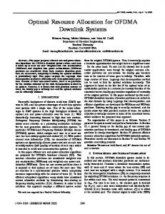
circumstances each region is more or less efficient in maximizing the use of these stock and service resources. Tools exist to judge how efficiently systems work but they focus on economic efficiency and they do not incorporate a comprehensive measure of transportation stock and service offered. Here, we emphasize social efficiency and bring measures of accessibility in the arsenal of resource management and resource allocation to show the degree of efficiency exhibited by different regions in enabling its residents to minimize personal costs and maximize personal benefits. The research findings presented in this report contain a two-component research program as mentioned in the preface above. The state of California is divided into geographical areas and each is treated as a production unit with its inputs represented by the different types of infrastructure (e.g., lane miles of roadways classified in a finite number of types). The outputs are indicators of the service offered to the unit’s residents in terms of the amount of activities the residents of each geographical area can reach. Figure 1 provides a summary of the schema used in this project.
8 K. Goulias, T. Golob, and S.Y. Yoon
FINAL REPORT – PATH TASK ORDERS 5110 & 6110 - October 2008
INPUT
Stock of facilities
- Highways by type Human capital Residents -Persons and households - Household composition
OUTPUT Activity opportunities surrounding each zone Opportunities measured by persons in occupations in rings Consider distance and travel time
Activity and travel behavior
- Car ownership
Figure 1 This project's schema
9 K. Goulias, T. Golob, and S.Y. Yoon
FINAL REPORT – PATH TASK ORDERS 5110 & 6110 - October 2008
2. Background Typical studies of transportation investment and economic development are discussed in Berechman (1994), Buffington et al. (1992), Perera (1990), Seskin (1990), and Weisbrod and Beckwith (1992).
There are also regional studies addressing the impact of transportation
infrastructure on local regional economic development. Assessment of these investments is based on the Gross Domestic (Regional) Product or private output as in Allen et al. (1988) and Wilson et al. (1985), benefit-cost ratios and/or differences as in Buffington et al. (1992) and Weisbrod and Beckwith (1992), property values as in Palmquist (1982) and new business creation or location as in Hummon et al. (1986). Analytical methods in these studies include: a) assessment of the effects of transportation infrastructure investments that compare and contrast the effects of investments among different regions; and b) identification of the important factors that influence and enable economic development. The study here belongs to the first group of analytical methods. Identification of the impacts from transportation infrastructure investment is particularly important when resources are scarce. From the perspective of decision makers, need assessment and accurate measurement of this need allows effective budgeting and financing of projects. It also allows for informed decisions while evaluating individual projects, balanced distribution of resources, and increased efficiency. Considerable research exists in the analysis of investment and optimal allocation of resources. Transportation improvements influence economic development, productivity, and social welfare. “Pure” economic development impacts are usually regional in nature and result from improved access to labor pools or to larger markets. While considering the economic development of different regions of a country, investment in transportation infrastructure as well as in the overall infrastructure system may play significant role in removing regional economic disparities. Within the same country and under the same development policies, significant role for transportation implies that regions with better transportation infrastructure will have better access to the locations of materials and markets making them more productive, competitive and hence more successful than regions with inferior transportation accessibility. Better accessibility and mobility also plays a significant role in human resource development of a region. For a review and an application using Data Envelopment Analysis, see Alam et al. 2004, an example of longitudinal analysis Alam et al. 2005, and a Stochastic Data Envelopment Analysis see Alam et al., 2008, and project by project economic assessment in Gkritza et al., 2008. 10 K. Goulias, T. Golob, and S.Y. Yoon
FINAL REPORT – PATH TASK ORDERS 5110 & 6110 - October 2008
One could make similar arguments when considering the time expenditures of individuals and households to paid and unpaid work as well as free time with family and friends. However, transportation investment from a “social efficiency” viewpoint is absent from transportation practice. This is mainly due to the lack of tools capable to assess the role of transportation investment on the efficient allocation of time by the residents of each locality. The tool we aim with the analysis presented here identifies specific locations in the state where resource allocation has succeeded in maximizing benefits to the public. In addition, we aim to develop maps that show which locations in a state fail to be optimal and require their residents to travel excessively to pursue the same amount of activities as other residents of different localities. More specifically in this report, we answer four key questions:
Using largely available data, can we develop a small number of variables to describe access to activity opportunities for California residents?
Are more roadways improving access to these activity opportunities?
Are these roles different for different types of highways and how?
Can we identify roadways that are prime candidates for investment? In this analysis the state of California is divided in 7049 zones using the US Census 2000
tracts.
The Census tract (unit of analysis here) is selected as a first order geographical
subdivision to make the analysis tractable at the state level and to provide sufficient detail to be meaningful (we will repeat this analysis with a smaller geographic unit and revisit this aspect in the conclusions). We assess each tract in terms of its ability to produce benefits for its residents. Figure 2 provides a schematic representation of the study and Table 1 contains a selection of unit of analysis characteristics.
11 K. Goulias, T. Golob, and S.Y. Yoon
FINAL REPORT – PATH TASK ORDERS 5110 & 6110 - October 2008
Assemble data for the 7049 tracts of California from US Census 2000 and Network of Roadways Compute buffers at 5, 10, and 50 km and 20 and 40 minutes using shortest path Sum the number of jobs within each buffer
Sum the number of lane km within each buffer
Develop optimality functions and perform assessment
Figure 2: Computation Schema of the Study
Envisioning each tract as a production unit and developing for each tract a production function, we measure access to opportunities, treat them as outputs, and correlate them to the presence of roadways within and surrounding the tract. Access to opportunities for activity participation (e.g., leisure) and services (e.g., health) is the benefit (and output) from each tract that we will assess. Using Geographic Information Systems we compute for each tract the amount of activity opportunities reachable within 5 km, 5 to 10 km, and 10 to 50 km. We repeat the same for 20 minutes and 20 to 40 minutes travel time computed using information about speed limits on the roadway network at hand. Computation of these measures is accomplished by developing an origin-destination network with the origins and destinations as centers (population weighted virtual centroids in each tract). Using the same origin-destination network we also count the number of highways within 5 km, 10 km, and 50 km network distance from each centroid.
12 K. Goulias, T. Golob, and S.Y. Yoon
FINAL REPORT – PATH TASK ORDERS 5110 & 6110 - October 2008
Table 1 A selection of Census-tract characteristics Mean
Std.Dev.
Maximum*
Tract Square Km
59.0
453.7
20486.8
Tract Population
4805.2
2143.1
36146.0
Tract Households
1631.8
763.0
8528.0
Workers in Retail (retail)
5031.1
6937.8
54745.0
Workers in Health (health)
2644.0
3524.4
26478.0
28024.4
44497.0
373127.0
Workers in Manufacturing (manufacturing)
3391.0
5547.7
59059.0
Workers in All Other Occupations (other)
5753.4
6805.7
50287.0
284.1
448.6
3244.8
77.9
140.6
958.5
Secondary and connecting roadways (secondary)
1867.8
2711.3
17711.4
Rural, local and neighborhood roadways (local)
8549.4
11256.1
71318.1
Special roadways (special)
342.1
591.3
4612.7
All Other types of roadways (other)
778.6
1618.7
10511.1
Within a 5 Km Buffer from Tract Centroid
Workers in Services but not in Health or Retail (services)
Primary limited access roadways (primary lim) Primary without limited access roadways (primary nolim)
*The minimum is zero for all variables and tracts
Enjoyment of access is also a function of the tract residents’ ability to take advantage of opportunities offered to them. We attempt to capture this by including social and demographic characteristics of the resident population available in the Census tract databases. Transportation investment is often directed to facilities and the striking majority of this investment is allocated to roadways. An indicator of transportation supply (the input in the context of production functions) is the amount of roadways (lane kilometres). Roadways, however, serve different purposes and offer different functions to the users depending on their type (e.g., limited access freeways/motorways, secondary roads connecting limited access roadways, local roads).
13 K. Goulias, T. Golob, and S.Y. Yoon
FINAL REPORT – PATH TASK ORDERS 5110 & 6110 - October 2008
Using Geographic Information Systems, we can identify and count the number of kilometres of each roadway in each tract. Roadways, however, form a complex network and the tracts are interconnected. For this reason, we perform a similar task as for activity opportunities and we count the number of roadways by type in a series of concentric rings of 5km, 5 to 10km, and 10 to 50km. We name these rings the buffers. We repeat the same operation for travel time using 20 minutes and 40 minutes travel time. The types of roadways we count are: primary highways with limited access (primary lim herein), primary roadways without limited access (primary nolim herein), secondary and connecting roadways (secondary herein), local and rural roads (local herein), roads with special characteristics (special herein), all other roadways (other herein). On the one hand, we have as input a detailed accounting of roadways representing all past investment on highways for each origin (tract centroid). On the other hand, we consider as output the number of workers a resident departing from a centroid can reach. The types of workers that are reachable within each of the buffers are classified into: retail, health, services, manufacturing, and all other. These counts are the indicators capturing access to opportunities to participate in activities and enjoy services.
14 K. Goulias, T. Golob, and S.Y. Yoon
FINAL REPORT – PATH TASK ORDERS 5110 & 6110 - October 2008
3. Optimality Assessment The literature on optimal assessment of decision making units is largely populated by Data Envelopment Analysis methods (a review on a related topic can be found in Alam et al. 2004, 2005, and 2008) and Stochastic Frontiers (Greene, 1980). Considering the possible measurement errors in the data used, the presence of outliers, and spatial correlation, we opt for stochastic frontiers that can handle some of these possibly undermining issues. However, an additional step is required in our analysis before estimating stochastic frontier production functions. The output of the number of workers that a resident departing from a centroid can reach is depicted by 25 indicators (number of workers in retail, health, services, manufacturing, and other within 5km, within the ring of 5 to 10 km, within the ring of 10 to 50 km, within 20 minutes of travel time, and within the ring of 20 to 40 minutes travel time). To reduce the data into a few variables we use factor analysis using the principal components method, extraction based on correlations, and the varimax method. This yields three components explaining 93% of the variation in the output variables used here. Each component captures a different aspect of access to opportunities surrounding each centroid and the three components are derived in such a way to be uncorrelated. Table 2 provides a summary of the component scores (high scores indicate high correlation between the output variable and the component extracted). The first component represents access of opportunities in the outermost ring between the radius of 50 km and the radius of 10 km but also within the ring defined by the radii of 20 and 40 minutes and for this named the outer ring access in this study. One variable, the number of workers in manufacturing within 20 minutes travel time, is more correlated with the first component than the second reflecting the predominant location of manufacturing in the outskirts of cities and closer to high speed roadways. The second component represents access to opportunities in the second ring and it is most correlated with variables defined in the ring between a radius of 5 km and a radius of 10 km (named middle ring access herein) and variables of within 20 minutes of travel time. Access to opportunities that are the closest to the centroid is represented by the third component (named core access herein), which is most correlated with the remaining variables.
For each
California tract we compute each of the three components (corresponding to three concentric regions around each centroid – core, middle ring, outer ring) using the scores of Table 2 and the value for each variable used to extract them. These three components replace the 25 variables and are used as the dependent variables in stochastic frontier analysis. 15 K. Goulias, T. Golob, and S.Y. Yoon
FINAL REPORT – PATH TASK ORDERS 5110 & 6110 - October 2008
Table 2 The three principal components extracted from 25 output variables and their scores Components Outer Middle Core Ring Ring Access Access Access Number of Workers in Retail (20 to 40 min) Number of Workers in Services (20 to 40 min) Number of Workers in Other (20 to 40 min) Number of Workers in Manufacturing (20 to 40 min) Number of Workers in Health (20 to 40 min) Number of Workers in Retail (10 to 50 km) Number of Workers in Manufacturing (10 to 50 km) Number of Workers in Other (10 to 50 km) Number of Workers in Services (10 to 50 km) Number of Workers in Health (10 to 50 km) Number of Workers in Manufacturing (0 to 20 min)
0.945 0.941 0.941 0.939 0.936 0.927 0.926 0.925 0.924 0.919 0.665
0.276 0.250 0.275 0.245 0.287 0.330 0.311 0.329 0.326 0.343 0.625
0.139 0.128 0.150 0.130 0.140 0.159 0.129 0.157 0.163 0.169 0.265
Number of Workers in Services (5 to 10 km) Number of Workers in Retail (5 to 10 km) Number of Workers in Other (5 to 10 km) Number of Workers in Health (5 to 10 km) Number of Manufacturing in Services (5 to 10 km) Number of Workers in Services (0 to 20 minutes) Number of Workers in Health (0 to 20 minutes) Number of Workers in Retail (0 to 20 minutes) Number of Workers in Other (0 to 20 minutes)
0.234 0.322 0.380 0.267 0.438 0.504 0.532 0.585 0.605
0.878 0.868 0.841 0.817 0.766 0.703 0.688 0.680 0.672
0.296 0.275 0.289 0.350 0.220 0.430 0.421 0.389 0.345
Number of Workers in Services (0 to 5 km) Number of Workers in Retail (0 to 5 km) Number of Workers in Other (0 to 5 km) Number of Workers in Health (0 to 5 km) Number of Workers in Manufacturing (0 to 5 km)
0.071 0.139 0.190 0.075 0.289
0.198 0.226 0.325 0.308 0.354
0.955 0.942 0.871 0.839 0.699
Stochastic frontiers were developed for models of production. A production function is the ideal amount a unit can produce for a given set of inputs. In empirical settings observed outputs are not ideal (maximum) for reasons that are due to unknown random factors and measurement error (v) that are specific to each observed unit and due to productive inefficiency that also varies with each observed unit (u).
To examine the relationship between output 16
K. Goulias, T. Golob, and S.Y. Yoon
FINAL REPORT – PATH TASK ORDERS 5110 & 6110 - October 2008
variables (access to opportunities) and input variables (highways) a regression model is created with dependent variable (y) the indicator of output and independent variables the highway lane kilometers (x). The model we use here takes the following form:
yi
= α + x'i β + vi − ui
Index i represents each tract, i=1,…, 7049. We estimate three regression equations that are one for each of the three components of Table 2 (core access, middle ring access, outer ring access). In each equation y is the logarithm of the component values for each tract. The xs are number of highways of each type in each geographic subdivision. The vector β contains the regression coefficients we seek. Variable v is the usual random error term capturing measurement error and variable u is a positive valued offset between observed access and the ideal maximum possible given the input combination of roadways within each tract. The random error term v is assumed to be normally distributed with zero mean and constant variance across observations. The random positive valued term u is specified as a function of other explanatory variables.
In the terminology of production
functions the values ui are the measures of inefficiency for each tract i in transforming lane kilometers of roadways into access to opportunities. Creating the exp(-ui ) we obtain a measure of tract specific efficiency. Estimation of the three models presented here is carried out using LIMDEP (Greene, 2002). Table 3 shows the regression coefficients associated with each input variable (number of lane kilometers of roadway types in the core, the middle ring, and the outer ring).
The
correlation between the y variable and its predicted values using the estimated model coefficients is 0.895 for the outer ring, 0.731 for the middle ring, and 0.744 for the core, representing excellent goodness of fit between data and the production function derived here.
17 K. Goulias, T. Golob, and S.Y. Yoon
FINAL REPORT – PATH TASK ORDERS 5110 & 6110 - October 2008
Table 3 Stochastic Frontier Regression Coefficients Constant Log(primary lim in core) Log(primary lim in core) 2 Log(primary nolim in core) Log(primary nolim in core) 2 Log(secondary in core) Log(secondary in core) 2 Log(local in core) Log(local in core) 2 Log(special in core) Log(special in core) 2 Log(other in core) Log(other in core) 2 Log(primary lim in middle ring) Log(primary lim in middle ring) 2 Log(primary nolim in middle ring) Log(primary nolim in middle ring) 2 Log(secondary in middle ring) Log(secondary in middle ring) 2 Log(local in middle ring) Log(local in middle ring) 2 Log(special in middle ring) Log(special in middle ring) 2 Log(other in middle ring) Log(other in middle ring) 2 Log(primary lim in outer ring) Log(primary lim in outer ring) 2 Log(primary nolim in outer ring) Log(primary nolim in outer ring) 2 Log(secondary in outer ring) Log(secondary in outer ring) 2 Log(local in outer ring) Log(local in outer ring) 2 Log(special in outer ring) Log(special in outer ring) 2 Log(other in outer ring) Log(other in outer ring) 2 Constant for u Household density Tract perimeter (km)
σ u /σ v
σ = σ 2 + σ v2
Outer Ring Coeff. t ratio -0.413 -3.13 -0.094 -1.71 -0.053 -2.29 0.016 0.23 0.001 0.05 0.035 0.94 -0.072 -5.71 -0.101 -3.75 0.021 2.89 0.068 1.21 0.045 2.02 -0.004 -0.22 -0.003 -0.47 0.098 2.33 0.077 5.83 0.048 3.44 0.028 5.13 -0.155 -3.18 -0.065 -6.13 0.025 0.63 0.015 2.14 -0.083 -1.78 -0.071 -5.22 0.034 1.76 0.021 4.80 0.077 1.47 -0.051 -2.56 -0.071 -2.18 0.007 0.75 -0.041 -0.66 0.030 2.27 0.066 1.40 0.007 0.90 -0.090 -1.80 0.093 6.18 0.012 0.47 -0.025 -5.63 -0.718 -8.06 -0.578 -69.66
Middle Ring Coeff. t ratio 0.857 13.80 0.203 11.17 0.070 8.48 -0.181 -8.11 -0.039 -5.26 -0.195 -13.96 -0.011 -2.07 0.091 8.28 0.020 6.55 -0.190 -10.05 -0.050 -5.91 -0.010 -1.53 -0.001 -0.59 -0.020 -1.07 -0.036 -6.60 0.039 9.50 0.003 1.69 0.146 6.08 0.044 9.09 -0.014 -0.69 -0.020 -6.01 0.085 4.37 0.061 11.10 -0.005 -0.69 0.006 3.93 -0.012 -0.36 0.025 2.71 0.045 3.16 -0.018 -3.85 0.006 0.17 -0.019 -2.65 -0.062 -1.73 0.003 0.62 0.058 1.97 -0.019 -2.72 0.005 0.42 0.002 0.74 -17.693 -14.36 1.059 10.34
Core Coeff. t ratio 1.685 17.89 0.443 13.01 0.135 8.95 0.477 10.25 0.137 9.17 0.748 25.71 0.172 19.97 -0.160 -7.86 -0.100 -20.05 -0.145 -4.59 -0.103 -6.92 -0.058 -5.36 -0.024 -6.66 -0.115 -3.70 -0.055 -6.56 -0.082 -9.54 -0.047 -13.76 -0.249 -6.01 -0.062 -7.06 0.059 1.69 0.058 10.11 -0.009 -0.25 0.012 1.28 0.042 3.13 0.023 8.69 0.002 0.03 -0.003 -0.20 0.041 1.70 0.000 -0.06 -0.008 -0.13 0.010 0.82 0.006 0.12 -0.010 -1.33 0.009 0.19 0.006 0.51 0.018 0.82 -0.008 -2.18 -0.144 -3.18
3.797
28.05
13.069
17.89
-1.375 2.612
-22.05 45.34
0.680
150.31
1.359
17.65
0.468
77.43
u
18 K. Goulias, T. Golob, and S.Y. Yoon
FINAL REPORT – PATH TASK ORDERS 5110 & 6110 - October 2008
The signs, size, and significance of the regression coefficients show how the presence and amount of different types of roadways impact the ability of each geographical tract to provide access to opportunities. A negative sign associated with roadways in the same region (core, middle ring, outer ring) of the dependent variable is more likely to indicate competition for space with businesses and establishments providing services. A positive coefficient is more likely to indicate a clustering of establishments around those roadway types. Positive coefficients associated with variables in different regions than the dependent variable indicate a supportive relationship with access. For example, access to the outer core may be achieved by driving over local roads in the core, secondary roads in the middle ring, and again local roads in the outer ring. Different establishments however, may be reached by different combinations of roadways. As a result we obtain a variety of significance levels, signs, and sizes of coefficients that may not all correspond to intuition. As expected, access to the outer core is influenced by roadway quantity in the core, the middle ring and the outer core. However, lower speed facilities in the core (local and secondary roadways) seem to have a stronger influence than the higher speed (primary roadways). The middle ring primary roadways have a strong positive impact on access in the outer ring. These two indications are a reflection of the routes leading to the outer core with high presence of opportunities. However, if there are many primary roadways in the outer core they compete for space with the establishments were opportunities locate and this is reflected in a few negative coefficients associated with roadways in the outer ring (primary nolim and secondary). Access to the middle ring is even more heavily influenced by the amount and type of roads in the core (positively by high speed roadways and negatively by lower speed roadways). The core access is not influenced by roadways in the outer ring, i.e., a driver does not need to go into the outer core when reaching places within the 5 km radius around a tract centroid and this is reflected in the lack of significance for most of the outer ring variables. In contrast, primary roadways in the middle ring seem to decrease access to the core in a significant way. This is a reflection of the spatial organization of California’s roadway network and the spatial distribution of activity opportunities adjacent to the network's roadways. Unfortunately, all this is also masked by the use of the summary indicators (i.e., the principal components) as dependent variables that contain variables from all three regions (i.e., core, middle ring, and outer ring). 19 K. Goulias, T. Golob, and S.Y. Yoon
FINAL REPORT – PATH TASK ORDERS 5110 & 6110 - October 2008
When aiming at improving access to opportunities around the core, however, provision of primary and secondary roadways appears to be a worthwhile investment. When we examine the other two components that are heavily influenced by variables that include travel time, the picture is not as clear and may be pointing out to the need for improving travel times in local and secondary roadways in regions that lead to the middle and outer rings. The bottom portion of Table 3 contains the estimates of variables influencing inefficiency. Exp (-ui ) is a measure of technical efficiency and it is the ratio between achieved access over the maximum possible access achieved for the given inputs. The outer ring and middle ring efficiencies (and their opposite inefficiencies) are significantly different among tracts of different household densities (households per square kilometers). The core efficiency is a function of the perimeter of the tract indicating a possible problem with the use of tract as a unit of analysis. In a series of other specifications not shown here we also find that multi-car (>4) households live in tracts with lower efficiency presumably because they are able to combat lack of access with automobility. Other variables considered such as number of households by household size did not exhibit a clear trend. The median efficiency indicators are fairly high at 84%, 92%, and 81% for the outer ring, middle ring, and core respectively. The tenth lower percentiles are 72%, 83% and 62% for the outer ring, middle ring, and core respectively indicating a fairly good efficiency for a system that evolved without a major plan targeting high efficiency. However, considering the large size of many tracts access to opportunities may be quite different among the residents within these tracts (see also the inequality section below). The final examination we perform for these computed efficiencies here is by mapping them for the entire state. Figure 3 shows the three efficiency indicators for Los Angeles, California, using as cutoff points the 10% percentiles. The first quadrant shows the Los Angeles total lane kilometers of roadways. Each efficiency estimate captures a different aspect of access to locations and shows clearly that providing more lane kilometers does not make a geographical area more accessible for any of the three efficiency measures. These same efficiency estimates were also computed for the entire state. Figure 4a shows the core efficiency map at 10% percentile increments.
Figure 4b shows the middle ring
efficiency and Figure 4c shows the outer ring efficiency.
20 K. Goulias, T. Golob, and S.Y. Yoon
FINAL REPORT – PATH TASK ORDERS 5110 & 6110 - October 2008
Total lane kilometers within core
Outer ring efficiency
Core efficiency
Middle ring efficiency
Figure 3: Maps of lane kilometers and efficiency measures in Los Angeles, California
21 K. Goulias, T. Golob, and S.Y. Yoon
FINAL REPORT – PATH TASK ORDERS 5110 & 6110 - October 2008
Core efficiency
Figure 4a Core Efficiency Estimates
22 K. Goulias, T. Golob, and S.Y. Yoon
FINAL REPORT – PATH TASK ORDERS 5110 & 6110 - October 2008
Middle ring efficiency
Figure 4b Middle Ring Efficiency Estimates
23 K. Goulias, T. Golob, and S.Y. Yoon
FINAL REPORT – PATH TASK ORDERS 5110 & 6110 - October 2008
Outer ring efficiency
Figure 4C Outer Ring Efficiency Estimates
24 K. Goulias, T. Golob, and S.Y. Yoon
FINAL REPORT – PATH TASK ORDERS 5110 & 6110 - October 2008
4. Inequality Assessment In this section a method to highlight the mismatch that exists between the distribution of the population and the allocation of roads and activity access in California is presented.
The
tool we aim with the analysis presented here identifies specific locations in the state where resource allocation has succeeded in offering a uniform spatial spread of benefits to the public. In addition, we aim to develop maps that show which locations in a country (a state in our study) fail to be equitable, requiring their residents to travel excessively to pursue the same amount of activities as other residents of different localities. In this section, we answer a few key questions:
Using largely available data, can we develop a small number of variables to describe access to activity opportunities for California residents?
Is it possible to capture the structure of inequality in accessibility through a multi-scale analysis?
Can we identify areas that are prime candidates for investment? To answer these questions the state of California is divided in 22,133 zones using the US
Census 2000 block groups. The Census block group (unit of analysis here) is selected as a first order geographical subdivision to make the analysis tractable at the state level and to provide sufficient detail to be meaningful. We assess each block group in terms of its ability to produce benefits for its residents and compare each block group with other block groups within a census tract. We will repeat the same comparison using tracts within counties, and counties within the state. Figure 5 provides a schematic representation of the study
25 K. Goulias, T. Golob, and S.Y. Yoon
FINAL REPORT – PATH TASK ORDERS 5110 & 6110 - October 2008
Assemble data for the 22,133 block groups of California from US Census 2000 and a 2000 Vintage Network of Roadways Compute buffers at 5, 10, and 50 km and 20, 40, and 60 minutes using shortest path
Sum the number of jobs within each buffer
Sum the number of lane km within each buffer
Develop summary indicators of accessibility
Create THEIL indicators for block groups, tracts, and counties
Figure 5: Computation Schema of the Inequality Study
Table 4 contains a selection of unit of analysis characteristics. Access to opportunities for activity participation (e.g., leisure) and services (e.g., health) is the benefit (and output) from each tract that we will assess. As indicators of available opportunities in a block group, numbers of workers classified according to the North American Industry Classification System (NAICS) were used. The original NAICS classification of fourteen types of industries was aggregated into five types: retail, health, services, manufacturing, and all other considering the types of activity in which people can participate related to the industries. Using Geographic Information Systems (Network Analyst in ArcGIS 9.1), we identified the areas reachable within 20 minutes, 40 minutes, and 60 minutes travel time using information about speed limits on the roadway network at hand. The network data we used for the analyses have information about types of road network, segment length, speed limit, turning restrictions, and one way street enabling a somewhat realistic modeling of the travel environment. Identification of the reachable areas is accomplished by developing two sets of shortest path networks for the origin-destination matrix of the block group centroids using travel time and travel distance as travel cost respectively, and querying the block groups by the travel costs. Combining the reachable areas with the numbers of workers in each block group, accessibility to
26 K. Goulias, T. Golob, and S.Y. Yoon
FINAL REPORT – PATH TASK ORDERS 5110 & 6110 - October 2008
activity participation was calculated as enumeration of workers of each industry within each reachable area. Table 4 A selection of block group characteristics Mean Std.Dev. Maximum* 18.51 179.59 12219.12 1530.3 1008.48 36146
Block Group Square Km Block group Population Block group Households Within a 20 min travel time buffer from block group Centroid Workers in Retail (retail) 56324.49 Workers in Health (health) 96664.34 Workers in Services but not in Health or Retail 23812.89 (services) Workers in Manufacturing (manufacturing) 80640.04 Workers in All Other Occupations (other) 75843.44 Primary limited access roadways (primary lim) 266.53 Primary without limited access roadways (primary 78.4 nolim) Secondary and connecting roadways (secondary) 650.52 Rural, local and neighborhood roadways (local) 2561.13 Special roadways (special) 23.2 All Other types of roadways (other) 223.78 *The minimum is zero for all variables and tracts
48926.91 89718.16 23757.93
202513 389816 87798
88937.65 68947.56 206.05 82.01
339848 270979 885.86 552.42
425.51 1782.39 39.44 275.34
2333.31 12545.59 483.4 1984.31
In a similar way as was done for the tract level, transportation supply is represented by the amount of roadways (lane kilometers) by type (e.g., limited access freeways/motorways, secondary roads connecting limited access roadways, local roads) but this time measured at the level of a US census block group. Using Geographic Information Systems, we can identify and count the number of kilometers of each roadway type in each block group. Roadways, however, form a complex network interconnecting the block groups and through the roadway network the block groups provide activity opportunities to others and also get benefits from others. For this reason, we perform a similar task as for activity opportunities and we sum up the length of roadway segments by type in a series of concentric areas that are accessible in 20 minutes, 40 minutes, and 60 minutes of travel time to quantify roadways that are available from an origin that is considered here as a virtual center of the block group (named centroid). We name these areas the buffers (similarly to the process followed in the previous section). The types of roadways we count are: primary highways with limited access (primary lim herein), primary roadways without limited access (primary nolim herein), secondary and connecting roadways (secondary herein), 27 K. Goulias, T. Golob, and S.Y. Yoon
FINAL REPORT – PATH TASK ORDERS 5110 & 6110 - October 2008
local and rural roads (local herein), roads with special characteristics (special herein), all other roadways (other herein). On one hand, we have as input a detailed accounting of roadways representing all past investment on highways for each origin and the number of workers a resident departing from a centroid can reach.
These counts are the indicators capturing access to opportunities to
participate in activities and enjoy services.
On the other hand, the main beneficiaries of
transportation policies are the number of persons residing in an origin block group. objective in transportation is to maximize accessibility for most persons.
One
However, some
segments of the population receive lower benefits than others. Inequality assessments are needed then to make comparisons. The assessment of inequality is very often limited to a few disadvantaged population segments (Blumenberg, 2008 - http://www.opportunitycars.com/articles/documents/ 20051205_Blumenberg.pdf) and they do not encompass an entire state or country in their assessment. In contrast, inequality is a very popular subject in other fields (Krugman and Venables, 1995, Schneider et al., 2002, Ghose, 2004). Considering the strong spatial correlation among accessibility indicators (due to the connectivity of highway network and the agglomeration of businesses) we opt for an index of inequality that has a "fractal" nature (i.e., decomposable geographically) and that can handle multiple output variables. The output of the number of workers that a resident departing from a centroid can reach is depicted by 25 indicators that are: number of workers in retail, health, services, manufacturing, and other employment within 5km, within 10 km, within 50 km, within 20 minutes of travel time, within 40 minutes of travel time, and within 60 minutes of travel time. To reduce the data into a few variables we use factor analysis using the principal components method and extraction based on correlations in the same manner we did for the tracts in the efficiency analysis. During a first stage using all the variables this method produced a few variables that were only marginally informative (as expected due to the strong relationship among the 25 variables considered here) and they were eliminated from further analysis. The reduced set of variables considered in this analysis produced only one factor that captures 90.03% of the variation in the variables used here. Table 5 provides a summary of the component scores (high scores indicate high correlation between the output variable and the component extracted). For each California block group we compute this “accessibility “ factor (ai, i=1,…, 22,133). Figure 6 shows the ratio 28 K. Goulias, T. Golob, and S.Y. Yoon
FINAL REPORT – PATH TASK ORDERS 5110 & 6110 - October 2008
ai/ni with ni the resident persons in each block group. These figures show the disparities that exist in providing accessibility at each block group. The figures, however, do not reflect the relationship of accessibilities between block groups and do not provide an indicator that compares them directly with the overall accessibility of the state and its spatial structure.
29 K. Goulias, T. Golob, and S.Y. Yoon
FINAL REPORT – PATH TASK ORDERS 5110 & 6110 - October 2008
Table 5 The factor created using a reduced set of the 25 output variables and their scores Variable NUMBER OF WORKERS IN MANUFACTURING INDUSTRY (WITHIN 20 MINUTE BUFFER) NUMBER OF WORKERS IN RETAIL INDUSTRY (WITHIN 20 MINUTE BUFFER) NUMBER OF WORKERS IN EDUCATION/HEALTH SERVICE INDUSTRY (WITHIN 20 MINUTE BUFFER) NUMBER OF WORKERS IN OTHER INDUSTRY (WITHIN 20 MINUTE BUFFER) NUMBER OF WORKERS IN MANUFACTURING INDUSTRY (WITHIN 40 MINUTE BUFFER) NUMBER OF WORKERS IN RETAIL INDUSTRY (WITHIN 40 MINUTE BUFFER) NUMBER OF WORKERS IN EDUCATION/HEALTH SERVICE INDUSTRY (WITHIN 40 MINUTE BUFFER) NUMBER OF WORKERS IN PUBLIC ADMINISTRATION INDUSTRY (WITHIN 40 MINUTE BUFFER) NUMBER OF WORKERS IN OTHER INDUSTRY (WITHIN 40 MINUTE BUFFER) NUMBER OF WORKERS IN MANUFACTURING INDUSTRY (WITHIN 60 MINUTE BUFFER) NUMBER OF WORKERS IN RETAIL INDUSTRY (WITHIN 60 MINUTE BUFFER) NUMBER OF WORKERS IN EDUCATION/HEALTH SERVICE INDUSTRY (WITHIN 60 MINUTE BUFFER) NUMBER OF WORKERS IN PUBLIC ADMINISTRATION INDUSTRY (WITHIN 60 MINUTE BUFFER) NUMBER OF WORKERS IN OTHER INDUSTRY (WITHIN 60 MINUTE BUFFER) PRIMARY HIGHWAY WITH LIMITED ACCESS(WITHIN 20 MINUTE BUFFER) LOCAL, NEIGHBORHOOD, and RURAL ROAD(WITHIN 20 MINUTE BUFFER) PRIMARY HIGHWAY WITH LIMITED ACCESS(WITHIN 20 MINUTE BUFFER) LOCAL, NEIGHBORHOOD, and RURAL ROAD(WITHIN 20 MINUTE BUFFER) PRIMARY HIGHWAY WITH LIMITED ACCESS(WITHIN 40 MINUTE BUFFER) SECONDARY and CONNECTING ROAD(WITHIN 40 MINUTE BUFFER) LOCAL, NEIGHBORHOOD, and RURAL ROAD(WITHIN 40 MINUTE BUFFER) SECONDARY and CONNECTING ROAD(WITHIN 40 MINUTE BUFFER)
Loading for accessibility factor 0.8669 0.9233 0.8957 0.8595 0.9675 0.9881 0.9828 0.9538 0.9757 0.9640 0.9719 0.9700 0.9490 0.9704 0.9313 0.9000 0.9852 0.9798 0.9570 0.9478 0.9439 0.9760
30 K. Goulias, T. Golob, and S.Y. Yoon
FINAL REPORT – PATH TASK ORDERS 5110 & 6110 - October 2008
Accessibility per capita in each block group
Theil index contribution by each block group
Figure 6 Accessibility and Theil Maps Under ideal data availability we would like to identify every resident of California, compute an accessibility index associated with each resident and then perform a comparative analysis to assess who enjoys higher accessibility and who does not. Although this is not an impossible task with today's modeling and simulation capabilities, it violates one of the initial requirements of this study of using largely available data to explore new techniques. In addition, accessibility of one location is related to the accessibilities of its neighbors. We start with block group subdivisions and compute an indicator that accounts for the distribution of accessibility. We then consider increasingly larger geographical areas to illustrate the use of the Theil index. The following equation shows the Theil index computed using the block group data in California.
31 K. Goulias, T. Golob, and S.Y. Yoon
FINAL REPORT – PATH TASK ORDERS 5110 & 6110 - October 2008
T=
22,133
∑ i =1
⎛ ⎜ ai log ⎜ A ⎜ ⎜ ⎝
ai A ni N
⎞ ⎟ ⎟ ⎟ ⎟ ⎠
Where A is the sum of factor values for the entire state of California (A=Σak) and N the population of the entire state of California (N= Σnk ). For each block group i, we name respectively accessibility share and population share the ratios ai/A and ni/N . An important advantage of this index over other measures of inequality is its composition. Each component of the sum in the equation above is a weighted log ratio of the accessibility over the resident population in the block group. Each component in the Theil index is then a weighted measure of the mismatch between its accessibility share and its population share. Thus, our interest will focus on each term of the sum, which we name contribution of the block group to the Theil index, or Theil contribution. The right hand side of Figure 6 displays these Theil contributions for each block group. This map is more instructive than the left hand side one since the block groups are compared to each other which allows to identify the relative status of each area as compared to the entire state in possible mismatches. The block groups colored in yellow are those that bring little of no contribution the Theil index. That means they can enjoy accessibility to roads and activities opportunities in the right proportion with respect to their population. On the other hand, the green colored areas are those that have an accessibility share higher that their population share offering excess advantage. This "over accessibility" is on the detriment of the red color areas for which the accessibility share is smaller than the population share. Consequently the inhabitants of those block groups may have to spend more travel time to accomplish the same amount of every day activities than their counterparts residents who live in advantaged areas. As far as infrastructure investment is concerned, a public policy aiming at an homogenous development of the state of California should consider the red colored areas as prime candidates for roadway connectivity funding allocation (of course other factors are usually taken into account in allocating resources). Figure 6 shows that major metropolitan areas such as Los Angeles are particularly advantaged in accessibility, but it seems that this over-accessibility was built at the detriment of the block groups that compose their outskirts and the ones that are situated in the
32 K. Goulias, T. Golob, and S.Y. Yoon
FINAL REPORT – PATH TASK ORDERS 5110 & 6110 - October 2008
central part of the State. It should be noted, however, that travel time here is computed based on the speed limit of roadways and therefore does not account for congestion. As a result this "advantage" of the urban core is somewhat exaggerated in this analysis. A fractal version of Theil's index enables assessment of inequality across larger regions as well as within larger regions to account for highway and land use connectivity. This is indeed the main characteristic that made us prefer the Theil index to all the other indexes developed in the economics literature. It is decomposable through different levels (e.g., geographical scales) and considers, for each scale unit, a between unit component and an intra unit component. In this way we can also account for heterogeneity within a larger area. As already mentioned above, a better way to measure inequality would be to consider each resident, but since, as most of analysts, we are dealing with groups, we have to study how inequality emerges between and inside these groups. Moreover this fractal approach gives us a deeper understanding of the spatial structure of inequality through the different levels we study. In our case study, the different geographical units we consider are the following: the County, the Tract and the Block group. Figure 7 displays the tree structure of the recursive calculation here. The state is composed of 58 counties. Each county contains tracts and each tract contains block groups. The general definition of the fractal Theil index is the following (Conceicao and Ferreira, 2000).
Tr =
Branches
∑ i =1
⎛ ⎜ ai . log⎜ A ⎜ ⎜ ⎝
ai A ni N
⎞ ⎟ Branches ai ⎟ + ∑ . T(r, i) A ⎟ i =1 ⎟ ⎠
Where ai is the accessibility of the branch i of the root r, A the total accessibility of the root r, ni the population of the branch i, N the total population of the root and T(r,i), the Theil index of the branch i.
33 K. Goulias, T. Golob, and S.Y. Yoon
FINAL REPORT – PATH TASK ORDERS 5110 & 6110 - October 2008
Applied to our case study, the formula becomes: NC
TCA = ∑ i =1
TCountyi =
⎛ ⎜ ai . log⎜ ACA ⎜ ⎜ ⎝
∑
Tract j of Counntyi
TTract j =
∑
ai ⎞ ⎟ NC ai ACA ⎟ + . TCounty i ∑ ni ⎟ i =1 ACA ⎟ NCA ⎠
Decomposition of the state by each county
⎛ aj ⎞ ⎜ ⎟ aj aj ACoutyi ⎟ ⎜ . log + . TTract j ∑ ⎜ nj ⎟ Tract j of Countyi ACoutyi ACoutyi ⎜ ⎟ ⎝ NCountyi ⎠
Blockgroup k of Tract j
⎛ ak ⎞ ⎜ ⎟ ATract j ⎟ . log⎜ ⎜ nk ⎟ ATract j ⎜ ⎟ ⎝ NTract k ⎠
Decomposition of each county by each tract within the county
Decomposition of each tract by block group within the tract
ak
California
County 1
Tract 1
Bg 1
Bg 2
County 2
Tract 2
County N
Tract M
Bg 3
Figure 7: Tree structure used for the computation of the fractal Theil index.
34 K. Goulias, T. Golob, and S.Y. Yoon
FINAL REPORT – PATH TASK ORDERS 5110 & 6110 - October 2008
Bringing all these components into one equation leads to the following.
NC
TCA = ∑ i =1
⎛ ⎜ ai . log⎜ ACA ⎜ ⎜ ⎝
⎡ ⎛ ⎛ aj ⎞ ⎛ ak ⎞ ⎞⎤ ai ⎞ ⎜ ⎜ ⎟ ⎜ ⎟ ⎟⎥ ⎟ ⎢ NC ai ⎢ aj aj ⎜ ak ACouty i ⎟ ATract j ⎟ ⎟⎥ ACA ⎟ + ⎜ ⎜ + ∑ . ∑ . log . . log ⎜ ∑ ⎜ nj ⎟ Tract ⎜ nk ⎟ ⎟⎥ ni ⎟ ∑ i =1 ACA ⎢ Tract j ACouty i j ACouty i Blockgroupk ATract j ⎟ ⎜ ⎜ ⎟ ⎜ ⎟⎟ ⎢ NCA ⎠ ⎝ NCounty i ⎠ ⎝ NTract k ⎠ ⎠⎥⎦ ⎝ ⎣
TCA = Between Countiescontribution
Intra county contribution Between tracts contribution
Intra-tract contribution
Figures 8, 9 and 10 display the results from this equation. Figure 10 is a statewide summary that displays two kinds of information. First, the contribution of the County to the Theil index, i.e the measure of the mismatch that exists between its accessibility share and its population share toward the other Counties. The other information is an “intra County” contribution that is actually its own Theil index and measures the inequality that exists between and inside its own tracts. Consequently, this map allows us to see, not only how advantaged or disadvantaged a County can be in regard to the others but also if its resources have been equally or unequally allocated showing the main advantage of the Theil index. It allows to understand the structure of inequality and its distribution through different geographic levels, and can thus constitute a decision making tool for public policies. Indeed, this map enables a policy maker to identify both what are the areas that need the most transport infrastructure for an egalitarian development of the State, and which regions have allocated their investments to projects that grant an homogeneous development of their own territory. The map allows to decide if a statewide equality will be emphasized and investments need to be made accordingly or if combating local inequality is more important and investments need to be made at a more local and focused way.
35 K. Goulias, T. Golob, and S.Y. Yoon
FINAL REPORT – PATH TASK ORDERS 5110 & 6110 - October 2008
Decomposition of the Theil contributions for each County 0.45 0.4 0.35 0.3 0.25 0.2 0.15 0.1 0.05 0 -0.05
between county contribution intra county contribution
1
11
21
31
41
51
61
71
81
91 101 111
County
Figure 8 Decomposition of the Theil contribution of each California County 0.015
Decomposition of the Theil contribution for each County
0.01 0.005 0 -0.005 -0.01 -0.015 between
-0.02
intra
-0.025 -0.03 1
9
17
25
33
43
51
61
69
77
85
93 101 109
County
Figure 9 Decomposition of the Theil contribution of each California County without Los Angeles (37) and Orange (59)
36 K. Goulias, T. Golob, and S.Y. Yoon
FINAL REPORT – PATH TASK ORDERS 5110 & 6110 - October 2008
Figure 10 Map of the decomposition of the Theil contribution of each County
37 K. Goulias, T. Golob, and S.Y. Yoon
FINAL REPORT – PATH TASK ORDERS 5110 & 6110 - October 2008
In California the most evident phenomenon that appears is the supremacy of the County of Los Angeles and Orange County in terms of both “over accessibility” (with, for LA, a contribution almost 45 times larger than the one of the third most advantaged County) and intra inequality (an intra inequality index about ten times larger than the one of the third most inhomogeneous County). This illustrates a property of the Theil index, its sensitivity to distributional impacts and disparities among the groups considered and in particular to "wealth" transfers from the disadvantaged to the advantaged. The measure of the mismatch is indeed amplified by the accessibility share weight (Conceicao and Ferreira, 2000, pages 12 and 13). Of course there is also a scale effect in all this. The larger a County is, the more likely it is to have internal heterogeneity. Among the other Counties, there is another trend that is worth noting. Counties that show the most lack of accessibility are also those with the highest intra-county inequality. This points out to the need for a more detailed study to identify those disadvantaged counties that did not benefit from large scale infrastructure investment such that would have allowed them to develop a coherent policy for an homogeneous development of their territory. The findings here show some sort of negative feedback; the less investment a County receives, the more it is likely to suffer from territorial disparities.
38 K. Goulias, T. Golob, and S.Y. Yoon
FINAL REPORT – PATH TASK ORDERS 5110 & 6110 - October 2008
5. Microanalysis (Person Based) Analysis In the development of the microanalysis in this project, we have identified relationships between travel, household sociodemographic characteristics, spatial accessibility, and road infrastructure. When considered separately, sociodemographic characteristics, spatial accessibility, and road infrastructure all influence travel behavior. Dense urban areas make walking trips more feasible; extensive networks of freeways and arterials encourage vehicular trips; large households make more trips per day than small households, and so on. However, in the real world, all of these variables interact simultaneously.
Households consider the costs and benefits of different
locations and feasible travel modes in light of their circumstances, and choose residential locations accordingly. Indeed, one could argue that households are not merely reacting to their circumstances, but rather are actively trying to improve their lot in any way they can. Adjustment strategies include moving residence, changing jobs, choosing different travel destinations, bundling individual single-occupancy vehicle (SOV) trips into high-occupancy vehicle (HOV) trips, and so on.
One cannot merely consider the influence of spatial
infrastructure characteristics in isolation and this motivates the development of regression analyses attempting to take into account multiple factors. One source of information about individuals and their households is the California Statewide Travel Survey, conducted over several months in the years 2000 and 2001. It provides an excellent starting point for disentangling the relationships between space, infrastructure, and sociodemographics. The survey sample, consisting of more than 17,000 households, is a quota sample by county and planning region, rather than a representative sample of California proportional to the population of each county. Each trip destination has been geocoded, usually to the nearest intersection, but sometimes to the approximate census tract centroid. The location (geocodes and census tract) of almost every household can also be determined from the survey data. To this data have been added spatial accessibility variables and roadway infrastructure variables by census tract and block group computed in the efficiency and inequality analysis discussed in previous sections of this report. The relatively even distribution of the sample across all California counties ensures that the data represent a wide variety of spatial environments. The need to account for (control) for sociodemographics when assessing relationships between travel behavior and spatial factors is revealed when we investigate the residential 39 K. Goulias, T. Golob, and S.Y. Yoon
FINAL REPORT – PATH TASK ORDERS 5110 & 6110 - October 2008
location patterns of sociodemographic groups.
Through a series of statistical tests, we
determined that eight categorical sociodemographic variables were paramount in explaining travel behavior. These variables with their categories and distributions by percent of the sample are listed in Table 6. Each of these five variables was strongly related to our spatial variables through residential location.
Table 6 Sociodemographic Variables Used in the Models Variable % Annual Household income