Article
Automatic Labelling and Selection of Training Samples for High-Resolution Remote Sensing Image Classification over Urban Areas Xin Huang 1,2, *, Chunlei Weng 2 , Qikai Lu 2 , Tiantian Feng 3 and Liangpei Zhang 2 Received: 22 June 2015; Accepted: 23 November 2015; Published: 1 December 2015 Academic Editors: Giles M. Foody, Norman Kerle and Prasad S. Thenkabail 1 2
3
*
School of Remote Sensing and Information Engineering, Wuhan University, Wuhan 430079, China The State Key Laboratory of Information Engineering in Surveying, Mapping and Remote Sensing, Wuhan University, Wuhan 430079, China;
[email protected] (C.W.);
[email protected] (Q.L.);
[email protected] (L.Z.) College of Surveying and Geo-Informatics, Tongji University, Shanghai 200092, China;
[email protected] Correspondence:
[email protected]; Tel./Fax: +86-27-6877-8525
Abstract: Supervised classification is the commonly used method for extracting ground information from images. However, for supervised classification, the selection and labelling of training samples is an expensive and time-consuming task. Recently, automatic information indexes have achieved satisfactory results for indicating different land-cover classes, which makes it possible to develop an automatic method for labelling the training samples instead of manual interpretation. In this paper, we propose a method for the automatic selection and labelling of training samples for high-resolution image classification. In this way, the initial candidate training samples can be provided by the information indexes and open-source geographical information system (GIS) data, referring to the representative land-cover classes: buildings, roads, soil, water, shadow, and vegetation. Several operations are then applied to refine the initial samples, including removing overlaps, removing borders, and semantic constraints. The proposed sampling method is evaluated on a series of high-resolution remote sensing images over urban areas, and is compared to classification with manually labeled training samples. It is found that the proposed method is able to provide and label a large number of reliable samples, and can achieve satisfactory results for different classifiers. In addition, our experiments show that active learning can further enhance the classification performance, as active learning is used to choose the most informative samples from the automatically labeled samples. Keywords: image classification; training samples; maximum likelihood classification; support vector machine; active learning
1. Introduction Classification is one of the most vital phases for remote sensing image interpretation, and the classification model learned from the training samples should be extended and transferred in the whole image. To date, many different pattern recognition methods have been successfully applied to remote sensing classification. Maximum likelihood classification (MLC) has proved to be robust for remote sensing images, as long as the data meet the distribution assumption (e.g., a Gaussian distribution) [1]. However, MLC does not achieve satisfactory results when the estimated distribution does not represent the actual distribution of the data [2]. In such cases, a single class may contain more than one component in the feature space, the distribution of which cannot be
Remote Sens. 2015, 7, 16024–16044; doi:10.3390/rs71215819
www.mdpi.com/journal/remotesensing
Remote Sens. 2015, 7, 16024–16044
described well with a single MLC. A Gaussian mixture model therefore deals with such complex situations better than simple MLC [3,4]. In order to avoid the distribution assumption, researchers have introduced non-parametric classifiers, such as the multi-layer perceptron (MLP) and support vector machine (SVM). The MLP has achieved good results in high-resolution image classification [5], pixel unmixing [6], change detection [7], and combination with other classification methods [8]. SVM has proven effective in hyperspectral image classification [9], high spatial resolution image classification [10], and multi-classifier ensemble strategies [11,12]. However, like MLC, SVM also suffers from the Hughes effect with a small-size training set [13]; thus, dimensionality reduction is important when training with limited samples. Meanwhile, the random forest (RF) classifier has received much attention in recent years, due to its robustness in high-dimensional classification problems. RF employs a bagging strategy to enhance the individual decision tree (DT), which is a weak classifier [14]. All the supervised classifiers introduced above need sufficient and efficient training samples, which are usually selected and labeled by visual inspection or field survey. However, collection of representative samples is expensive, both in terms of time and money [15]. Thus, researchers have introduced semi-supervised methods to solve the problem of insufficient sampling, by considering the unlabeled samples in an image. Meanwhile, active learning [16–22] has received increasing attention in recent years, aiming to reduce the cost of training sample selection by only labelling the most uncertain samples. Active learning has been extensively studied in the existing literature, for applications such as diverse sample selection [16], multi-view strategies [17], convergence [18], optimization of field surveying [19], image segmentation [20], and domain adaptation [21]. In general, however, most of the classification algorithms depend on manually labeled samples, even though semi-supervised learning and active learning need fewer labeled samples [15,23]. To the best of our knowledge, there have been few papers discussing machine learning methods that can automatically label training samples from remote sensing images. In this context, we propose to automatically select and label the training samples on the basis of a set of information sources, e.g., the morphological building/shadow index (MBI, MSI) [24,25], the normalized difference water/vegetation index (NDWI, NDVI) [26,27], the HSV color space, and open-source geographical information system (GIS) data, e.g., road lines from OpenStreetMap (OSM) [28]. These information indexes can be automatically obtained from remote sensing images, and hence have the potential to select and label training samples for buildings, shadow, water, vegetation, and soil, respectively. The objective of this study is to automate remote sensing image classification, and alleviate the intensity of manual image interpretation for choosing and labelling samples. Please note that active learning is a tool for selecting the most informative samples, but not for automatically labelling them. However, the proposed method can simultaneously select and label samples, especially for high-resolution images. An interesting point in this paper is that the OSM, which publically provides detailed road lines all around the world, is used to generate the samples of roads. Subsequently, in order to automatically collect reliable training samples, a series of processing steps are proposed to refine the initial samples that are directly extracted from the indexes and OSM, including removing overlaps, removing borders, and semantic constraints. In the experiments, four test datasets, as well as a large-size dataset, were used to evaluate the proposed method, using four state-of-the-art classifiers: MLC, SVM, MLP, and RF. Section 2 introduces the information indexes, the HSV color system, and OSM, based on which the automatic sampling method is proposed in Section 3. The classifiers considered in this study are briefly described in Section 4. The experimental results are provided in Section 5, followed by a detailed analysis and discussion in Section 6. Section 7 concludes the paper. 2. Information Sources for Automatic Sample Collection In this section, the four information indexes used to generate the initial candidate training samples are introduced. MBI, MSI, NDWI, and NDVI can automatically indicate the information
16025
Remote Sens. 2015, 7, 16024–16044
classes of building, shadow, water, and vegetation, respectively [29]. The HSV color space is used to describe the distribution of the soil and road lines are provided by OSM. In [29], these multiple information indexes were integrated and interpreted by a multi-kernel learning approach, aiming to classify high-resolution images. In addition, the MBI has proven effective for building change detection, where the change in the MBI index is considered as the condition for building change in urban areas [30]. Morphological Building Index (MBI): Considering the fact that the relatively high reflectance of roofs and the spatially adjacent shadows lead to the high local contrast of buildings, the MBI aims to build the relationship between the spectral-structural characteristics of buildings and the morphological operators [25]. It is defined as the sum of the differential morphological profiles (DMP) of the white top-hat (W-TH): ÿ (1) MBI= DMPW-THpd,sq d,s
W-THpd, sq=I-γIre pd, sq
(2)
where γIre represents the opening-by-reconstruction of the brightness image (I), and d and s denote the parameters of direction and scale, respectively. The white top-hat DMP is used to represent the local contrast of bright structures, corresponding to the candidate building structures [25]. Morphological Shadow Index (MSI): Considering the low reflectance and the high local contrast of shadow, the MSI can be conveniently extended from the MBI by replacing the white top-hat (W-TH) with the black top-hat (B-TH): ÿ MSI= DMPB-THpd,sq (3) d,s
B-THpd, sq=ϕIre pd, sq-I
(4)
where ϕIre represents the closing-by-reconstruction of the brightness image, and is used to represent the local contrast of shadows [25]. The MBI and the MSI have achieved satisfactory results in terms of accuracies and visual interpretation in experiments [24,25]. In this study, they are used to generate the initial training samples for buildings and shadows, respectively. Normalized Difference Water Index (NDWI): Water has a low reflection in the infrared channel and a high reflection in the green channel [26]. Therefore, the NDWI makes use of this difference to enhance the description of water, and is defined as: NDW I “
BGreen ´ BN IR BGreen ` BN IR
(5)
Normalized Difference Vegetation Index (NDVI): According to the different reflection of vegetation canopies in the NIR and red channels [27], the NDVI is defined as: NDV I “
BN IR ´ BRed BN IR ` BRed
(6)
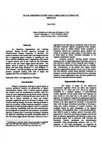
HSV Color System: HSV is a common color system, standing for hue (0~1), saturation (0~1), and value (0~1). The HSV color system is able to quantitatively describe the color space for an image [31]. In this research, HSV transform is used to detect the soil components which present as yellow or yellowish-red in the color space. Open Street Map (OSM): OSM is a free, editable map of the whole world, which contains a large amount of location information, especially abundant and detailed road lines [28]. In this research, the road networks are registered with the corresponding remote sensing images, and the training samples for roads can then be obtained. As shown in Figure 1, accurate and reliable road sample detection consists of four steps: (a) registering the OSM road lines with the image; (b) removing the
16026
Remote Sens. 2015, 7, 16024–16044
samples labeled by other classes; (c) removing short lines; and (d) sample extraction by buffering the Remote Sens. 2015, 7 page–page road lines.
(a)
(b)
(c)
(d)
Figure 1.Figure Detection of road samples: (a)(a)registering OSMroad road lines the image; (b) removing 1. Detection of road samples: registering OSM lines withwith the image; (b) removing samples labeled by other classes; (c) removing short lines; and (d) sample extraction by buffering samples labeled by other classes; (c) removing short lines; and (d) sample extraction by buffering road lines. road lines.
A graphic example of a WorldView-2 image is used to show the effectiveness of the information A graphic example of a WorldView-2 image is used to show the effectiveness of the information indexes, the HSV-based soil detection, as well as the OSM road lines for the automatic sample indexes, the HSV-based soil detection, as well as the OSM road lines for the automatic sample collection (Figure(Figure 2). From the illustrations, it can bebe clearly theseinformation information sources can collection 2). From the illustrations, it can clearlyseen seen that that these sources provide can effective of buildings, shadow, vegetation, and roads. The visual providedescriptions effective descriptions of buildings, shadow,water, water, vegetation, soil,soil, and roads. The visual resultsthat showitthat it is possible to automatically select select candidate training samples. In particular, the results show is possible to automatically candidate training samples. In particular, the soil components are highlighted as dark green in the HSV space, and can be detected as soil. However, soil components are highlighted as dark green in the HSV space, and can be detected as soil. it should be noted that there are overlaps between some similar classes, e.g., water and shadows. However, it should be noted that there are overlaps between some similar classes, e.g., water and This suggests that the samples generated from the information sources cannot be directly used for shadows. This suggests that the samples classification, and refinement processinggenerated is needed. from the information sources cannot be directly used for classification, and refinement processing is needed.
16027
provide effective descriptions of buildings, shadow, water, vegetation, soil, and roads. The visual results show that it is possible to automatically select candidate training samples. In particular, the soil components are highlighted as dark green in the HSV space, and can be detected as soil. However, it should be noted that there are overlaps between some similar classes, e.g., water and shadows. This that the samples generated from the information sources cannot be directly Remote Sens. 2015, 7, suggests 16024–16044 used for classification, and refinement processing is needed.
Remote Sens. 2015, 7 page–page
(a)
(b)
(c)
Figure 2. Cont.
4
(d)
(e)
(f)
Figure Multiple information sources, including (a) Roads OSM; (b) MBI; (c) MSI; (d) Figure 2. 2.Multiple information sources, including (a) Roads fromfrom OSM; (b) MBI; (c) MSI; (d) NDWI; (e) NDVI; the for HSV space, the for initial selecting the set initial samplebuildings, set for roads, (e)NDWI; NDVI; and (f) the and HSV (f) space, selecting sample for roads, shadow, buildings, shadow, water, vegetation, and soil, respectively. water, vegetation, and soil, respectively.
AutomaticSample Sample Selection Selection 3. 3.Automatic This section introduces the proposed method for the automatic selection of training samples for This section introduces the proposed method for the automatic selection of training samples buildings, shadow, water, vegetation, roads and soil, as illustrated in Figure 3, including the for buildings, shadow, water, vegetation, roads and soil, as illustrated in Figure 3, including the following steps. following steps. (1) Select initial training samples of buildings, shadow, water, vegetation, soil, and roads, (1) Select respectively, initial training of buildings, fromsamples the multiple information shadow, sources. water, vegetation, soil, and roads, respectively, from the multiple information (2) Samples located at the border areas aresources. likely to be mixed pixels, and, thus, it is difficult to (2) Samples located at the border areas are likely tolabel. be mixed pixels, and,introducing thus, it is incorrect difficult to automatically assign these pixels to a certain In order to avoid automatically these pixels to a samples certain label. In orderwith to avoid introducing incorrect training trainingassign samples, these border are removed an erosion operation. (3) Manual alwaysare prefers homogeneous areas and disregards outliers. Therefore, in samples, these sampling border samples removed with an erosion operation. study, area thresholding is applied to areas the candidate samples, and theTherefore, objects whose (3) Manualthis sampling always prefers homogeneous and disregards outliers. in this areas are smaller than a predefined value are removed. study, area thresholding is applied to the candidate samples, and the objects whose areas are smaller than a predefined value are removed. (4) The obtained samples should be further refined, in order to guarantee the accuracy of the samples. Considering the fact that buildings and shadows are always spatially adjacent, the distance between the buildings and their neighboring shadows should be smaller than a threshold, which is used to remove unreliable buildings and shadows from the sample sets. Meanwhile, the road lines obtained from OSM are widened by several pixels, forming a series of buffer areas, where road samples can be picked out. (5) Considering the difficulty and uncertainty in labelling samples in overlapping regions, the samples that are labeled as more than one class are removed.
16028 (a)
(b)
(2) Samples located at the border areas are likely to be mixed pixels, and, thus, it is difficult to automatically assign these pixels to a certain label. In order to avoid introducing incorrect training samples, these border samples are removed with an erosion operation. (3) Manual sampling always prefers homogeneous areas and disregards outliers. Therefore, in this 7,study, area thresholding is applied to the candidate samples, and the objects whose Remote Sens. 2015, 16024–16044 areas are smaller than a predefined value are removed.
(a)
(b)
Figure3. 3. An An example example ofofaacomparison comparisonbetween betweenthe theinitial initialsamples samplesderived derivedfrom fromthe themultiple multiple Figure information sources and the samples refined proposed method (orange = buildings, magenta information sources and the samples refined byby thethe proposed method (orange = buildings, magenta shadow, blue water, green = vegetation, cyan = roads, and yellow = soil).(a)(a)Initial Initialsamples; samples; = =shadow, blue = =water, green = vegetation, cyan = roads, and yellow = soil). (b)(b) Refined samples. Refined samples.
The whole processing chain for the automatic sample selection is summarized in the following algorithm. Please note that the values of the parameters, mainly referring to the binarization 5 threshold values for the multiple information indexes, and the area threshold values used to remove the small and heterogeneous points, can be conveniently determined and unified in all the test images. The suggested threshold values used in this study are not fixed, and can be appropriately tuned in different image scenes, but rather represent a first empirical approach. Algorithm: Automatic selection of training samples 1: Inputs: 2: Multiple information sources (MBI, MSI, NDWI, NDVI, HSV, OSM). 3: Manually selected thresholds (TB , TS , TW , TV ). 4: Step1: Select initial training samples from the information sources. 5: Step2: Erosion (SE=diamond, radius = 1) is used to remove samples from borders. 6: Step3: Minimal area (m2 ): ABuild = 160, AShadow = 20, AWater = 400, AVege = 200, and Asoil = 400. 7: Step4: Semantic processing: 8: (1) The distance between buildings and their adjacent shadows is smaller than 10 m (about 9: five pixels in this study). 10: (2) Road lines are widened for buffer areas. 11: Step5: Remove overlapping samples. In Figure 3, the initial samples extracted by the multiple information sources and the samples refined by the proposed algorithm are compared, from which it can be seen that the pure samples for the land-cover classes are correctly labeled in an automatic manner. 4. Classifiers Considered in This Study In this paper, four classifiers MLC, SVM, RF, and MLP are used to implement the proposed automatic training sample selection method. The chosen classifiers have proven effective in many remote sensing applications [32]. (1) Maximum Likelihood Classification: MLC is a statistical approach for pattern recognition. For a given pixel, the probability of it belonging to each class is calculated, and it is assigned to the class
16029
Remote Sens. 2015, 7, 16024–16044
with the highest probability [14]. Normally, the distribution of each class in the multi-dimension space is assumed to be a Gaussian distribution. The mean and covariance matrix of MLC are obtained from the training samples, and used to effectively model the classes. If the training set is biased compared to the normal distribution, the estimated parameters will not be very accurate. (2) Support Vector Machine: SVM is a binary classification method based on minimal structural risk, and it can be extended to multi-class classification with multi-class strategies. When dealing with linearly separable datasets, the optimal decision line is obtained by maximizing the margin between the two parallel hyperplanes. This type of SVM ensuring that all the samples are classified correctly is called hard-margin SVM. On the other hand, allowing the existence of misclassified training samples, soft-margin SVM introduces slack variables for each sample. SVM generates nonlinear decision boundaries by mapping the samples from a low-dimension space to a high-dimension one, and the kernel trick is used to avoid the definition of the mapping function [33]. An SVM model is constructed by support vectors, which usually locate in the decision boundary region between the class pairs. The most representative and informative samples will be close to the boundary of the class pair [15,34]. A better sample set for training an SVM model is not to accurately describe the classes, but to provide information about the decision boundary between the class pairs in the feature space [35]. Meanwhile, in the case of a small-size sample set, the outliers have an obvious influence on the decision boundary. (3) Neural Networks: NNs can be viewed as a parallel computing system consisting of an extremely large number of simple processors with interconnections [32]. NNs are able to learn complex nonlinear input-output relationships, use sequential training procedures, and adapt themselves to the data [32]. The MLP is one of the most commonly used NNs. It consists of input, hidden, and output layers, where all the neurons in each layer are fully connected to the neurons in the adjacent layers. These interconnections are associated with numerical weights, which are adjusted iteratively during the training process [36]. Each hidden neuron performs a mapping of the input feature space by a transform function. After an appropriate mapping by the previous layer, the next layer can learn the classification model as a linearly separable problem in the mapped feature space, and thus NNs are able to deal with nonlinearly separable datasets [8]. In this study, the conjugate gradient method (e.g., scaled conjugate gradient, SCG), is used for training of the MLP, since it can avoid the line search at each learning iteration by using a Levenberg-Marquardt approach to scale the step size [36]. (4) Decision Tree: A hierarchical DT classifier is an algorithm for labelling an unknown pattern by the use of a decision sequence. The tree is conducted from the roof node to the terminal leaf, and the feature for each interior node is selected by information gain or the Gini impurity index. A pruning operation is employed in simplifying the DT without increasing errors [14]. Due to the unsatisfactory performance, an ensemble of DTs, such as RF, is more commonly used than the simple DT [37]. RF combines predictors from trees, and the final result of a sample is the most popular class among the trees. Each tree is conducted via a sub-randomly selected sample set and a sub-randomly selected feature space [38]. Each tree in RF is grown to the maximum depth, and not pruned. RF is relatively robust to outliers and noise, and it is insensitive to over-fitting [14]. 5. Experiments and Results A series of test images were used to validate the proposed method for the automatic selection of training samples. In the experiments, the proposed method was compared with the traditional method (i.e., manually collected samples), in order to verify the feasibility of the automatically selected samples.
16030
Remote Sens. 2015, 7, 16024–16044
5.1. Datasets and Parameters Figure 4 shows the four test datasets, as well as the manually selected samples (the ground truth). The study areas are located in Hangzhou, Shenzhen, Hong Kong, and Hainan, respectively, with a size of 640 ˆ 594, 818 ˆ 770, 646 ˆ 640, and 600 ˆ 520 in pixels, as well as a resolution of 2 m, Remote 2.4 m,Sens. 2 m, 2 m. These datasets were acquired by WorldView-2, GeoEye-1, WorldView-2, 2015,and 7 page–page and WorldView-2, respectively, with eight, four, four, and eight spectral bands, respectively The Theexhibit parameters the linear structuring (SE) for the MBI and the in MSI, including study areas the of characteristics of a setelement of typical urban landscapes China, andthe mainly minimal value, maximal value, and the interval, {Smin, Smax, ΔS,}, can be determined according to the consist of six classes: buildings, shadow, water, vegetation, roads, and bare soil. The six classes spatial size of the buildings and the spatial resolution of the images used. These parameters were can be automatically extracted by the proposed method, the effectiveness of which was tested in the unified in this study as: Smin = 8 m, Smax = 70 m, and ΔS = 2 m, respectively. In addition, the binarization experiments. the for manually collected samples, 40% the labeled samples wereofrandomly selected thresholdFor values the information indexes were set of according to the suggestions our previous from study the ground truth as the training sample set (named ROI in the following text), while the rest [25]. Please note that these thresholds can be simply and conveniently determined since we were used merely for theaim testing (Table 1). and reliable samples for the further consideration. to choose pure
(a)
(b)
Figure 4. Cont. Figure 4. Cont.
16031 8
Remote Sens. 2015, 7, 16024–16044 Remote Sens. 2015, 7 page–page
(c)
(d) Figure 4. The images (left) and ground truth (right) used in the experiments: (a) Hangzhou; (b)
Figure 4. The images (left) and ground truth (right) used in the experiments: (a) Hangzhou; Shenzhen; (c) Hong Kong; and (d) Hainan (orange = buildings, magenta = shadow, blue = water, (b) Shenzhen; (c) Hong Kong; and (d) = buildings, magenta = shadow, blue = water, green = vegetation, cyan = roads, andHainan yellow =(orange soil). green = vegetation, cyan = roads, and yellow = soil). Table 1. Numbers of training samples (ROI) and test samples, which were manually generated (in pixels).
Hangzhou Shenzhen Hong Kong Table 1. Numbers of training samples (ROI) and test samples, which wereHainan manually generated ROI Test ROI Test ROI Test ROI Test (in pixels).
Building Shadow Water Vegetation Road Soil
Building 13,004 Shadow 5742 Hangzhou Water 6186 ROI Test Vegetation 7118 13,004 19,507 Road 3784 5742 8614 Soil 400 6186 9279 7118 3784 400
10,678 5678 601
19,507 16,598 24,897 8614 9774 14,661 Shenzhen 9279ROI13,759 Test 20,639 10,678 12,829 19,244 16,598 24,897 5678 5185 7778 9774 14,661 60113,759 256 20,639 385 12,829 5185 256
19,244 7778 9 385
12,388 18,583 4631 3788 5682 570 Hong Kong 11,725 17,588 4,483 ROI Test 6042 9063 8601 12,388 18,583 1264 1898 2142 3788 5682 496 74617,5888875 11,725 6042 1264 496
9063 1898 746
6947 857 Hainan 6726 ROI Test 12,902 4631 6947 3214 570 857 13,314 4,483 6726 8601 2142 8875
12,902 3214 13,314
The parameters of the linear structuring element (SE) for the MBI and the MSI, including the minimal value, maximal value, and the interval, {Smin , Smax , ∆S,}, can be determined according to the spatial size of the buildings and the spatial resolution of the images used. These parameters 16032
Remote Sens. 2015, 7, 16024–16044
were unified in this study as: Smin = 8 m, Smax = 70 m, and ∆S = 2 m, respectively. In addition, the binarization threshold values for the information indexes were set according to the suggestions of our previous study [25]. Please note that these thresholds can be simply and conveniently determined since we merely aim to choose pure and reliable samples for the further consideration. For the SVM classifier, the radial basis function (RBF) kernel was selected, and the regularization Remote Sens. 2015, 7 page–page parameter and kernel bandwidth was optimized by five-fold cross-validation. For the RF classifier, 500 trees were The classifier was carried with two layers, and the Forconstructed. the SVM classifier, theMLP radial basis function (RBF) kernel out was selected, andhidden the regularization number of neurons inkernel each layer was was alsooptimized optimized five-fold cross-validation. parameter and bandwidth by by five-fold cross-validation. For the RF classifier, 500experiments, trees were constructed. MLP classifier wasmeans carriedthat out with two hidden layers, andwas the trained In the trainingThe with ROI or Auto the classification model number labeled of neurons in each layer was also optimized by five-fold cross-validation. with manually samples or automatically labeled samples, respectively. Each classification In the experiments, training with ROI or Auto means that the classification model was trained was conducted 10 times with different initial training samples that were randomly chosen from the with manually labeled samples or automatically labeled samples, respectively. Each classification candidatewas training sample set,with anddifferent the average werethat recorded as the classification conducted 10 times initialaccuracies training samples were randomly chosen from theaccuracy. For each candidate classification experiment, 100 training samples per class were used for training. training sample set, and the average accuracies were recorded as thethe classification accuracy. For each classification experiment, 100 training samples per class were used for the training.
5.2. Results 5.2. Results
The automatically selected training samples of the four datasets are displayed in Figure 5, and The automatically selected training samples of the four datasets are displayed in Figure 5, and their numbers are provided in Table 2. 2.ItItcan clearlyobserved observed the automatically their numbers are provided in Table can be be clearly thatthat the automatically labeled labeled samples are correct, pure, pure, and representative, distributed inwhole the whole samples are correct, and representative,and andare are uniformly uniformly distributed in the image. image.
(a)
(b)
(c)
(d)
Figure 5. Automatically labeled samples from the four datasets (orange = buildings,
Figure 5. Automatically labeled from the cyan four = datasets buildings, magenta = shadow, blue = water,samples green = vegetation, roads, and(orange yellow = =soil). magenta (a) = shadow, blue water, green = vegetation, = roads, and yellow = soil). (a) Hangzhou; Hangzhou; (b)=Shenzhen; (c) Hong Kong; (d)cyan Hainan. (b) Shenzhen; (c) Hong Kong; (d) Hainan. 10
16033
Remote Sens. 2015, 7, 16024–16044
Table 2. Numbers of automatically selected training samples (in pixels).
Buildings Shadow Water Vegetation Roads Soil
Hangzhou
Shenzhen
Hong Kong
Hainan
10,686 7282 17,418 29,801 8210 269
24,177 10,306 34,307 83,425 2938 852
12,287 7126 41,569 44,571 2211 2263
3208 1419 13,572 85,022 6170 27,369
In general, from Table 3, the Auto samples achieve satisfactory accuracies, which are close to the accuracies achieved by the ROI samples. In particular, for the Shenzhen and Hong Kong datasets, the classification results obtained by the Auto samples are very similar and comparable to the manually selected ones, for all the classifiers. With respect to the Hangzhou and Hainan datasets, the accuracy achieved by the proposed automatic sampling is also acceptable (80%~90%), although their accuracy scores are slightly lower than the ROI samples by an average of 4%~7%. Considering the fact that the proposed method is able to automatically select samples from the images, it can be stated that the method is effective, making it possible to avoid time-consuming manual sample selection. Table 3. The overall classification accuracies for the four datasets.
Hangzhou Shenzhen Hong Kong Hainan
Auto ROI Auto ROI Auto ROI Auto ROI
MLC (%)
SVM (%)
RF (%)
MLP (%)
79.3 ˘ 1.7 83.1 ˘ 1.7 81.8 ˘ 0.7 82.8 ˘ 0.9 91.3 ˘ 0.6 92.2 ˘ 0.7 88.3 ˘ 0.9 94.1 ˘ 0.5
80.4 ˘ 2.0 85.6 ˘ 0.8 84.4 ˘ 1.0 85.0 ˘ 0.9 90.2 ˘ 0.9 90.3 ˘ 1.6 86.5 ˘ 1.9 92.4 ˘ 0.7
82.1 ˘ 1.2 86.8 ˘ 0.9 84.0 ˘ 1.1 85.1 ˘ 0.4 91.2 ˘ 0.5 90.4 ˘ 1.1 85.4 ˘ 0.8 90.2 ˘ 0.6
82.6 ˘ 1.2 86.4 ˘ 1.2 83.1 ˘ 2.0 85.1 ˘ 0.8 91.0 ˘ 0.7 91.1 ˘ 0.9 86.1 ˘ 0.9 93.4 ˘ 0.5
When comparing the performances of the different classifiers with the Auto sampling, MLC achieves the highest accuracies in two test datasets (Hong Kong and Hainan). However, generally speaking, all the classifiers perform equally in the four test images, showing the robustness of the proposed automatic sampling method in different scenes. 5.3. Large-Size Image Testing The previous experiments verified that the proposed automatic sampling strategy is able to achieve satisfactory classification results over the four urban images. We also tested the practicability of the automatic method by the use of a large-size image from the Shenzhen city center, which is China’s first and most successful Special Economic Zone. The dataset was acquired on 25 March 2012, by the WorldView-2 satellite, covering 92 km2 with a 2-m spatial resolution, consisting of eight spectral bands. As shown in Figure 6, the dataset (named WV-2 in the following text) covers the city center of Shenzhen, and three sub-regions are manually labeled as the source of the training samples (ROI). Please note that the whole image was manually labeled as the ground truth for testing, in order to guarantee the reliability of the experimental conclusions. The numbers of available samples for ROI, Auto, and test are provided in Table 4. The parameters used in this experiment were the same as the previous ones. The classification results, including the quantitative accuracy scores and the classification maps, are shown in Table 5 and Figure 7, respectively. The experimental results convey the following observations:
16034
Remote Sens. 2015, 7, 16024–16044
‚ InRemote general, the classification accuracies obtained by the automatic sampling are very promising Sens. 2015, 7 page–page (80%~85%), which shows that it is fully possible to automatically classify large-size remote • images In general, the classification accuracies obtained by the automatic sampling are very sensing over urban areas. promising (80%~85%), which shows that it classifiers, is fully possible to automatically large- the ‚ By comparing the performances of the different it can be seen that classify MLC achieves size remote sensing images over urban areas. highest accuracy for the Auto samples, while SVM and the MLP give the best results for the • By comparing the performances of the different classifiers, it can be seen that MLC achieves ROI samples. the highest accuracy for the Auto samples, while SVM and the MLP give the best results for ‚ It is interesting see that in the case of MLC, the automatic sampling strategy significantly the ROIto samples. outperforms manualtosampling overall accuracy. • It isthe interesting see that inby the8% caseinofthe MLC, the automatic sampling strategy significantly outperforms the manual sampling by 8% in the overall accuracy.
MLC performs better than the other classifiers with the automatic sampling. This phenomenon MLC performs better than the other classifiers with the automatic sampling. This phenomenon can be explained by: (1) the difference in the properties between the Auto and ROI samples; can be explained by: (1) the difference in the properties between the Auto and ROI samples; and (2) and (2) the difference in the decision rules between the classifiers. the difference in the decision rules between the classifiers.
(a)
(b)
(c)
Figure 6. WV-2 Shenzhen image, as well as the three sub-regions as the source of the training sample
Figure 6. WV-2 Shenzhen image, as well as the three sub-regions as the source of the training set (ROI): ground truth of the whole image; automatically selected training sample set (Auto) sample set (ROI): ground truth of the whole image; automatically selected training sample set (Auto) (orange = buildings, magenta = shadow, blue = water, green = vegetation, cyan = roads, yellow = soil). (orange buildings, magenta shadow, = water, green = vegetation, cyanset. = roads, yellow = soil). (a)=WV-2 urban image and = training set;blue (b) Ground truth; (c) Automatic training (a) WV-2 urban image and training set; (b) Ground truth; (c) Automatic training set. 12
16035
Remote Sens. 2015, 7, 16024–16044
Table 4. Numbers of samples for ROI, Auto, and test (in pixels).
Remote Sens. 2015, 7 page–page
Land Cover Test and test (in pixels). Auto Table 4. Numbers ofROI samples for ROI, Auto,
Land Cover ROI Test Auto Buildings 118,130 1,313,843 191,811 Shadow 14,446 185,650 76,723 Buildings 118,130 1,313,843 191,811 Water 140,823 865,113 683,317 Shadow 14,446 185,650 76,723 Vegetation 98,225 1,542,442 6,667,588 Water 140,823 865,113 683,317 Roads 32,942 313,572 171,312 Vegetation 98,225 1,542,442 6,667,588 Soil 52,944 391,949 100,707 Roads 32,942 313,572 171,312 Soil 52,944 391,949 100,707 Table 5. The overall accuracy of the classification for the WV-2 large-size image. Table 5. The overall accuracy of the classification for the WV-2 large-size image.
Strategy Strategy Auto Auto ROI ROI
MLC (%) MLC (%) 84.2±˘ 84.2 1.01.0 76.9 ˘ 2.2 76.9 ± 2.2
SVM (%) SVM (%) 81.8 1.7 81.8 ˘ ± 1.7 84.0 ˘ 1.5 84.0 ± 1.5
RF (%) RF (%) 80.9 ˘±1.2 80.9 1.2 82.6 ˘ 1.2 82.6 ± 1.2
MLP (%) MLP (%) 82.582.5 ˘ 0.9 ± 0.9 84.9 ˘ 1.3 84.9 ± 1.3
(a)
(b) Figure 7. Classification maps of the large-size WV-2 image with the Auto and ROI training samples.
Figure 7. Classification maps of the large-size WV-2 image with the Auto and ROI training (a) Classification maps using the Auto training samples with MLC (left) and SVM (right); samples. (a) Classification maps using the Auto training samples with MLC (left) and SVM (right); (b) Classification maps using the ROI training samples with MLC (left) and SVM (right). (b) Classification maps using the ROI training samples with MLC (left) and SVM (right).
13
16036
Remote Sens. 2015, 7 page–page Remote Sens. 2015, 7, 16024–16044
1. It should be noted that the Auto samples are purer than ROI, since the automatic selection prefers homogeneous andsamples reliable are samples in order to avoid errors and uncertainties. 1. It should be noted that the Auto purer than ROI, since the automatic selection prefers Specifically, described in Algorithm pixels which are uncertain and mixed homogeneous andasreliable samples in order1,toboundary avoid errors and uncertainties. Specifically, as have been removed, and the area thresholding further reduces the isolated and described in Algorithm 1, boundary pixels which are uncertain and mixed have been removed, heterogeneous pixels.further reduces the isolated and heterogeneous pixels. and the area thresholding 2. The four classifiers considered this study be separated into parametric classifiers 2. The four classifiers considered in thisinstudy can becan separated into parametric classifiers (MLC), (MLC), and non-parametric classifiers (SVM, RF,The andprinciple MLP). The principle MLC isthe to and non-parametric classifiers (SVM, RF, and MLP). of MLC is to of construct constructforthe distributions classes, butmethods the non-parametric tend to distributions different classes,for butdifferent the non-parametric tend to definemethods the classification define the classification decision boundaries between differentpure land-cover classes. decision boundaries between different land-cover classes. Consequently, samples are more Consequently, pure samples are more appropriate for non-parametric MLC, but an effective sampling for appropriate for MLC, but an effective sampling for the classifiers is highly the non-parametric classifiers is highly reliant on the samples near the decision boundaries reliant on the samples near the decision boundaries so that they can be used to separate the so that they can be used to separate the different classes. different classes. 6. 6. Discussions Discussions In issues regarding thethe proposed automatic sampling method are In this thissection, section,several severalimportant important issues regarding proposed automatic sampling method discussed, including the the influence of of thethe number of oftraining are discussed, including influence number trainingsamples, samples,the theeffectiveness effectiveness of of the the classifiers classifiers for for the automatic training samples, and the limitations of the proposed approach. 6.1. Number Number of of Training Training Samples Samples 6.1. In this this experiment, experiment, the the classification classification was was conducted conducted with with different different numbers numbers of of training training samples samples In extracted by ROI and Auto, respectively. The large-size WV-2 image of Shenzhen city was taken as extracted by ROI and Auto, respectively. The large-size WV-2 image of Shenzhen city was taken as an example. example. The The results results are are demonstrated demonstrated in in Figure Figure 8, 8, where where the the general general conclusion conclusion is is that, that, for for both both an ROI and Auto sampling, increasing the number of training samples does not significantly increase ROI and Auto sampling, increasing the number of training samples does not significantly increase the classification classificationaccuracy accuracyafter after500~1000 500~1000samples samples per class chosen. In addition, it be canseen be seen the per class areare chosen. In addition, it can that that Auto-MLC can provide much higher accuracies than ROI-MLC, which shows that the proposed Auto-MLC can provide much higher accuracies than ROI-MLC, which shows that the proposed automatic sampling sampling method method is is aa satisfactory satisfactory sampling sampling strategy strategy for for the the MLC MLC classifier. classifier. The The CPU CPU time time automatic for the thevarious variousclassifiers classifierswith withdifferent differenttraining training samples is recorded in Figure 8b. Here, can be for samples is recorded in Figure 8b. Here, it canitbe seen seen that MLP and SVM are more sensitive to the number of training samples, and a large number of that MLP and SVM are more sensitive to the number of training samples, and a large number of samples lead to more computational time. RF is less sensitive to the training sample number, as the samples lead to more computational time. RF is less sensitive to the training sample number, as the CPU time time tends tends to to be be invariant invariant when when the the number number of of samples samples is is larger larger than than 1500 1500 pixels It CPU pixels per per class. class. It should be noted that MLC, which aims to describe the probability of the class distribution, is totally should be noted that MLC, which aims to describe the probability of the class distribution, is totally insensitive to to the the number number of of training training samples. samples. insensitive
(a) Figure Figure 8. 8. Cont. Cont.
14 16037
Remote Sens. 2015, 7, 16024–16044 Remote Sens. 2015, 7 page–page Remote Sens. 2015, 7 page–page
(b) (b) Figure 8. 8. The accuracies (a) and computational times; times; (b) with with different numbers numbers of training training samples. Figure Figure 8.The Theaccuracies accuracies(a) (a)and andcomputational computational times;(b) (b) withdifferent different numbersof of trainingsamples. samples. Auto-MLC and ROI-MLC represent the results achieved by the use of the Auto and ROI samples with with Auto-MLC Auto-MLCand andROI-MLC ROI-MLCrepresent representthe theresults resultsachieved achievedby bythe theuse useofofthe theAuto Autoand andROI ROIsamples samples with MLC, respectively. MLC, MLC,respectively. respectively.
6.2. Further Comparison Between Between Auto and and ROI Sampling Sampling 6.2. 6.2.Further FurtherComparison Comparison BetweenAuto Auto andROI ROI Sampling In order order to further further analyze and and understand the the automatic training training samples, in in this subsection, subsection, In In orderto to furtheranalyze analyze andunderstand understand theautomatic automatic trainingsamples, samples, inthis this subsection, the class class distributions derived derived from the the ROI, Auto, Auto, and test test samples are are demonstrated and and compared. the the classdistributions distributions derivedfrom from theROI, ROI, Auto,and and testsamples samples aredemonstrated demonstrated andcompared. compared. In this analysis, MLC (Figure 9) and SVM (Figure 10) are taken as a representative example for the the In Inthis thisanalysis, analysis,MLC MLC(Figure (Figure9) 9)and andSVM SVM(Figure (Figure10) 10)are aretaken takenas asaarepresentative representativeexample examplefor for the parametric and and non-parametric classifiers, classifiers, respectively. In In the figures, figures, the distributions distributions are illustrated illustrated parametric parametric andnon-parametric non-parametric classifiers,respectively. respectively. Inthe the figures,the the distributionsare are illustrated with a two-dimensional feature space (first and second principal components, namely, PCA1 and with with aa two-dimensional two-dimensional feature feature space space (first (first and and second second principal principal components, components, namely, namely,PCA1 PCA1and and PCA2). From Figure 9, in the case of MLC, it can be clearly observed that the shape of the decision PCA2). From Figure 9, in the case of MLC, it can be clearly observed that the shape of the decision PCA2). From Figure 9, in the case of MLC, it can be clearly observed that the shape of the decision boundaries for for the Auto Auto and reference reference samples are are quite similar. similar. This reveals reveals that the the automatically boundaries boundaries forthe the Autoand and referencesamples samples arequite quite similar.This This revealsthat that theautomatically automatically selected samples are effective for modelling the probabilistic distributions of land-cover classes. selected selectedsamples samplesare areeffective effectivefor formodelling modellingthe theprobabilistic probabilisticdistributions distributionsofofland-cover land-coverclasses. classes.
(a) (a) Figure 9. Cont. Figure9.9.Cont. Cont. Figure
16038 15 15
Remote Sens. 2015, 7 page–page Remote Sens. 2015, 7, 16024–16044 Remote Sens. 2015, 7 page–page
(b)
(b)
(c)
(c) and (c) reference samples for the MLC classifier. Figure 9. Decision boundaries of (a) ROI; (b) Auto;
Figure 9. Decision boundaries of (a) ROI; (b) Auto; and (c) reference samples for the MLC classifier. Figure 9. Decision boundaries of (a) ROI; (b) Auto; and (c) reference samples for the MLC classifier.
(a) Figure 10. Cont.
16 (a) Figure10. 10.Cont. Cont. Figure
16 16039
Remote Sens.2015, 2015,7,716024–16044 page–page Remote Sens.
(b)
(c) Figure10. 10.Decision Decisionboundaries boundariesofof(a) (a)ROI; ROI;(b) (b)Auto; Auto;and and(c) (c)reference referencesamples samplesfor forthe theSVM SVMclassifier. classifier. Figure
In addition, it can be seen that the decision boundaries derived from the Auto samples are more In addition, it can be seen that the decision boundaries derived from the Auto samples are more similar to those derived from the reference samples than those from the ROI samples, which can be similar to those derived from the reference samples than those from the ROI samples, which can be used to explain and support the conclusion in Table 5. used to explain and support the conclusion in Table 5. On the other hand, in the case of the SVM classifier, as demonstrated in Figure 10, it can be seen On the other hand, in the case of the SVM classifier, as demonstrated in Figure 10, it can be seen that the boundaries derived from ROI are closer to the boundaries of the reference samples than the that the boundaries derived from ROI are closer to the boundaries of the reference samples than the Auto sampling, which is reflected in the classification accuracy, i.e., 81.8% for Auto-SVM and 84.0% Auto sampling, which is reflected in the classification accuracy, i.e., 81.8% for Auto-SVM and 84.0% for ROI-SVM, respectively. As explained previously, the accuracy of the non-parametric classifiers is for ROI-SVM, respectively. As explained previously, the accuracy of the non-parametric classifiers is highly reliant on the samples near the decision boundaries (for instance, the so-called support vectors highly reliant on the samples near the decision boundaries (for instance, the so-called support vectors for the SVM classification), but automatic sampling is more capable of identifying the homogeneous for the SVM classification), but automatic sampling is more capable of identifying the homogeneous and pure samples which are far from the decision boundaries. Therefore, in the case of SVM, the and pure samples which are far from the decision boundaries. Therefore, in the case of SVM, the manually labeled samples seem more suitable than the automatically selected ones. This analysis is manually labeled samples seem more suitable than the automatically selected ones. This analysis is also consistent with the accuracies reported in Table 5. also consistent with the accuracies reported in Table 5. 6.3.Active ActiveLearning Learningfor forthe theAutomatic AutomaticSampling Sampling 6.3. Aspreviously previouslyshown, shown,the theproposed proposedapproach approachisisable abletotoautomatically automaticallyand andeffectively effectivelylabel label As samplesfor fordifferent differentland-cover land-coverclasses. classes. On Onthe theother otherhand, hand,active activelearning learningcan canselect selectthe themost most samples informative samples from the available sample set by considering the contribution of each sample to 17 16040
Remote Sens. 2015, 7, 16024–16044
Remote Sens. 2015, 7 page–page
informative samples from the available sample set by considering the contribution of each sample to classifier. regard, is interesting to integrate proposed automatic sample labelling thethe classifier. In In thisthis regard, it isitinteresting to integrate the the proposed automatic sample labelling and and active learning for sample selection optimization. processing chain is straightforward: active learning for sample selection andand optimization. The The processing chain is straightforward: The The candidate sample various land-coverclasses classesare areselected selectedand and labeled labeled by the proposed candidate sample setssets forfor various land-cover proposed automatic and these samples are then by activeby learning terms of in their contribution automaticstrategy, strategy, and these samples areranked then ranked active inlearning terms of their to the classifier. In classifier. this study,Inthe classifier is classifier considered, and the commonly used breaking contribution to the thisSVM study, the SVM is considered, and the commonly used ties (BT) method is adopted the sample Note thatNote the that SVMthe parameters (kernel breaking ties (BT)[39] method [39] is for adopted for theselection. sample selection. SVM parameters parameter and penalty are retunedare during the active learning iterations. Theiterations. experimental (kernel parameter andcoefficient) penalty coefficient) retuned during the active learning The results for the active with the automatically labeled samples labeled are presented in Figure 11 for the experimental resultslearning for the active learning with the automatically samples are presented in four test datasets. It can be clearly seen that in the Shenzhen, Hong Kong, and Hainan experiments, Figure 11 for the four test datasets. It can be clearly seen that in the Shenzhen, Hong Kong, and active (Auto-AL) can learning provide additional increments compared to the original Hainanlearning experiments, active (Auto-AL) accuracy can provide additional accuracy increments automatic approach (Auto-SVM). In approach the case of(Auto-SVM). Hangzhou, active outperforms the comparedsampling to the original automatic sampling In thelearning case of Hangzhou, active original algorithm in the early stage, but does not perform as well after about 300 samples are chosen. learning outperforms the original algorithm in the early stage, but does not perform as well after However, general, difference is not in significant. Therefore, it is can besignificant. stated thatTherefore, active learning about 300 in samples arethe chosen. However, general, the difference not it can can further optimize the proposed sample labellingthe method, since it canlabelling select the most informative be stated that active learning can further optimize proposed sample method, since it can samples bymost considering theirsamples importance in the classification. select the informative by considering their importance in the classification.
(a)
(b)
(c)
(d)
Figure11. 11. Accuracy Accuracy curves curves of of the the active active learning learning by by using using the the automatically automatically labeled labeled samplesfor samplesforthe the Figure four test images: (a) Hangzhou; (b) Shenzhen; (c) Hong Kong; (d) Hainan, respectively. Auto-AL and four test images: (a) Hangzhou; (b) Shenzhen; (c) Hong Kong; (d) Hainan, respectively. Auto-AL and Auto-SVMdenote denoteSVM SVMclassification classificationwith withand andwithout withoutactive activelearning, learning,respectively. respectively. Auto-SVM
7. Conclusions and Future Scope 7. Conclusions and Future Scope In this paper, a novel method for automatic sample selection and labelling for image In this paper, a novel method for automatic sample selection and labelling for image classification in urban areas is proposed. The training sample sets are obtained from multiple classification in urban areas is proposed. The training sample sets are obtained from multiple information sources, such as soil from the HSV color space, roads from OSM, and automatic information indexes referring to buildings, shadow, vegetation, and water. A series of processing 16041
18
Remote Sens. 2015, 7, 16024–16044
information sources, such as soil from the HSV color space, roads from OSM, and automatic information indexes referring to buildings, shadow, vegetation, and water. A series of processing steps are further used to refine the samples that are initially chosen, e.g., removing overlaps, removing borders, and semantic filtering. The experiments with four test datasets showed that the proposed automatic training sample labelling method (Auto) is able to achieve satisfactory classification accuracies, which are very close to the results obtained by the manually selected samples (ROI), with four commonly used classifiers. Furthermore, the experiments with a large-size image (WorldView-2 image from Shenzhen city, 92 km2 ) showed that the proposed method is able to achieve automatic image classification with a promising accuracy (84%). It was also found that the automatic sampling strategy is more suitable for maximum likelihood classification (MLC), which aims to describe the probabilistic distribution of each land-cover class. In particular, in the experiments, active learning [40] was jointly used with the proposed Auto sampling method, in order to select the most informative samples from the automatically labeled samples. The results were interesting and promising, as active learning could further improve the classification accuracies by about 2%~4% in most of the test sets. The significance of this study lies in the fact that it has showed that automatic sample selection and labelling from remote sensing images is feasible and can achieve promising results. Our future research will address the mixing of manually and automatically selected samples. In this way, the decision boundaries generated by the Auto method could be further enhanced by adding new samples and removing wrong ones. It will also be possible to evaluate and compare the importance of manual and automatic samples for classification. In addition, the samples used for the accuracy assessment will be generated randomly, in order to avoid any bias in the results [41]. Acknowledgments: The authors would like to thank the editor and the anonymous reviewers for their comments and suggestions. This work was supported by the National Natural Science Foundation of China under Grant 91338111, the China National Science Fund for Excellent Young Scholars under Grant 41522110, and the Foundation for the Author of National Excellent Doctoral Dissertation of PR China (FANEDD) under Grant 201348. Author Contributions: Xin Huang and Chunlei Weng proposed the idea of the automatic selection of training samples, undertook the experiments, and organized the writing and revision of the paper. Tiantian Feng, Qikai Lu, and Liangpei Zhang provided advice on the preparation of the experiments and the revision of the paper. Conflicts of Interest: The authors declare no conflict of interest.
References 1. 2.
3. 4. 5. 6.
7.
Wang, L.; Sousa, W.P.; Gong, P.; Biging, G.S. Comparison of IKONOS and QuickBird images for mapping mangrove species on the caribbean coast of panama. Remote Sens. Environ. 2004, 91, 432–440. [CrossRef] Zhang, L.; Huang, X.; Huang, B.; Li, P. A pixel shape index coupled with spectral information for classification of high spatial resolution remotely sensed imagery. IEEE Trans. Geosci. Remote Sens. 2006, 44, 2950–2961. [CrossRef] Dundar, M.M.; Landgrebe, D. A model-based mixture-supervised classification approach in hyperspectral data analysis. IEEE Trans. Geosci. Remote Sens. 2002, 40, 2692–2699. [CrossRef] Richards, J.A.; Kingsbury, N.G. Is there a preferred classifier for operational thematic mapping? IEEE Trans. Geosci. Remote Sens. 2014, 52, 2715–2725. [CrossRef] Del Frate, F.; Pacifici, F.; Schiavon, G.; Solimini, C. Use of neural networks for automatic classification from high-resolution images. IEEE Trans. Geosci. Remote Sens. 2007, 45, 800–809. [CrossRef] Licciardi, G.; Del Frate, F. A neural network approach for pixel unmixing in hyperspectral data. In Proceedings of the 2nd Workshop on Hyperspectral Image and Signal Processing: Evolution in Remote Sensing, Reykjavik, Iceland, 14–16 June 2010. Roy, M.; Routaray, D.; Ghosh, S.; Ghosh, A. Ensemble of multilayer perceptrons for change detection in remotely sensed images. IEEE Geosci. Remote Sens. 2014, 11, 49–53. [CrossRef]
16042
Remote Sens. 2015, 7, 16024–16044
8.
9. 10. 11.
12. 13. 14. 15. 16. 17. 18. 19.
20. 21. 22. 23. 24.
25. 26. 27.
28. 29. 30. 31. 32.
Santos, A.B.; de Albuquerque Araújo, A.; Menotti, D. Combining multiple classification methods for hyperspectral data interpretation. IEEE J. Sel. Top. Appl. Earth Observ. Remote Sens. 2013, 6, 1450–1459. [CrossRef] Melgani, F.; Bruzzone, L. Classification of hyperspectral remote sensing images with support vector machines. IEEE Trans. Geosci. Remote Sens. 2004, 42, 1778–1790. [CrossRef] Bruzzone, L.; Carlin, L. A multilevel context-based system for classification of very high spatial resolution images. IEEE Trans. Geosci. Remote Sens. 2006, 44, 2587–2600. [CrossRef] Huang, X.; Zhang, L. An SVM ensemble approach combining spectral, structural, and semantic features for the classification of high-resolution remotely sensed imagery. IEEE Trans. Geosci. Remote Sens. 2013, 51, 257–272. [CrossRef] Huang, X.; Zhang, L. Comparison of vector stacking, multi-SVMs fuzzy output, and multi-svms voting methods for multiscale vhr urban mapping. IEEE Geosci. Remote Sens. Lett. 2010, 7, 261–265. [CrossRef] Pal, M.; Foody, G.M. Feature selection for classification of hyperspectral data by SVM. IEEE Trans. Geosci. Remote Sens. 2010, 48, 2297–2307. [CrossRef] Mather, P.; Tso, B. Classification Methods for Remotely Sensed Data, 2nd ed.; Taylor and Francis: Abingdon, UK, 2004. Tuia, D.; Volpi, M.; Copa, L.; Kanevski, M.; Munoz-Mari, J. A survey of active learning algorithms for supervised remote sensing image classification. IEEE J. Sel. Top. Signal Process. 2011, 5, 606–617. [CrossRef] Demir, B.; Persello, C.; Bruzzone, L. Batch-mode active-learning methods for the interactive classification of remote sensing images. IEEE Trans. Geosci. Remote Sens. 2011, 49, 1014–1031. [CrossRef] Di, W.; Crawford, M.M. View generation for multiview maximum disagreement based active learning for hyperspectral image classification. IEEE Trans. Geosci. Remote Sens. 2012, 50, 1942–1954. [CrossRef] Patra, S.; Bruzzone, L. A novel SOM-SVM-Based active learning technique for remote sensing image classification. IEEE Trans. Geosci. Remote Sens. 2014, 52, 6899–6910. [CrossRef] Persello, C.; Boularias, A.; Dalponte, M.; Gobakken, T.; Naesset, E.; Scholkopf, B. Cost-sensitive active learning with lookahead: Optimizing field surveys for remote sensing data classification. IEEE Trans. Geosci. Remote Sens. 2014, 52, 6652–6664. [CrossRef] Mitra, P.; Shankar, B.U.; Pal, S.K. Segmentation of multispectral remote sensing images using active support vector machines. Pattern Recognit. Lett. 2004, 25, 1067–1074. [CrossRef] Persello, C.; Bruzzone, L. Active learning for domain adaptation in the supervised classification of remote sensing images. IEEE Trans. Geosci. Remote Sens. 2012, 50, 4468–4483. [CrossRef] Rajan, S.; Ghosh, J.; Crawford, M.M. An active learning approach to hyperspectral data classification. IEEE Trans. Geosci. Remote Sens. 2008, 46, 1231–1242. [CrossRef] Sinno Jialin, P.; Qiang, Y. A survey on transfer learning. IEEE Trans. Knowl. Data Eng. 2010, 22, 1345–1359. Huang, X.; Zhang, L. A multidirectional and multiscale morphological index for automatic building extraction from multispectral GeoEye-1 imagery. Photogramm. Eng. Remote Sens. 2011, 77, 721–732. [CrossRef] Huang, X.; Zhang, L. Morphological building/shadow index for building extraction from high-resolution imagery over urban areas. IEEE J. Sel. Top. Appl. Earth Observ. Remote Sens. 2012, 5, 161–172. [CrossRef] Gao, B.-C. NDWI—A normalized difference water index for remote sensing of vegetation liquid water from space. Remote Sens. Environ. 1996, 58, 257–266. [CrossRef] Goward, S.N.; Markham, B.; Dye, D.G.; Dulaney, W.; Yang, J. Normalized difference vegetation index measurements from the advanced very high resolution radiometer. Remote Sens. Environ. 1991, 35, 257–277. [CrossRef] Bennett, J. Openstreetmap: Be Your Own Cartographer; Packt Publishing: Birmingham, UK, 2010. Huang, X.; Lu, Q.; Zhang, L. A multi-index learning approach for classification of high-resolution remotely sensed images over urban areas. ISPRS J. Photogramm. Remote Sens. 2014, 90, 36–48. [CrossRef] Tang, Y.; Huang, X.; Zhang, L. Fault-tolerant building change detection from urban high-resolution remote sensing imagery. IEEE Geosci. Remote Sens Lett. 2013, 10, 1060–1064. [CrossRef] Wikipedia. Available online: https://en.wikipedia.org/wiki/HSL_and_HSV (accessed on 25 November 2015). Jain, A.K.; Duin, R.P.W.; Mao, J. Statistical pattern recognition: A review. IEEE Trans. Pattern Anal Mach. Intell. 2000, 22, 4–37. [CrossRef]
16043
Remote Sens. 2015, 7, 16024–16044
33. 34. 35.
36. 37. 38. 39.
40. 41.
Abe, S. Support Vector Machines for Pattern Classification; Springer: Berlin, Germany, 2010. Zadrozny, B. Learning and evaluating classifiers under sample selection bias. In Proceedings of the 21th International Conference on Machine Learning, Banff, AB, Canada, 4–8 June 2004. Foody, G.M.; Mathur, A. The use of small training sets containing mixed pixels for accurate hard image classification: Training on mixed spectral responses for classification by a svm. Remote Sens. Environ. 2006, 103, 179–189. [CrossRef] Møller, M.F. A scaled conjugate gradient algorithm for fast supervised learning. Neural Netw. 1993, 6, 525–533. [CrossRef] Breiman, L. Random forests. Mach. Learn. 2001, 45, 5–32. [CrossRef] Pal, M. Random forest classifier for remote sensing classification. Int. J. Remote Sens. 2005, 26, 217–222. [CrossRef] Luo, T.; Kramer, K.; Samson, S.; Remsen, A.; Goldgof, D.B.; Hall, L.O.; Hopkins, T. In Active learning to recognize multiple types of plankton. In Proceedings of the 17th International Conference on Pattern Recognition, Cambridge, UK, 23–26 August 2004; Volume 473, pp. 478–481. Persello, C.; Bruzzone, L. Active and semisupervised learning for the classification of remote sensing images. IEEE Trans. Geosci. Remote Sens. 2014, 52, 6937–6956. [CrossRef] Olofsson, P.; Foody, G.M.; Herold, M.; Stehman, S.V.; Woodcock, C.E.; Wulder, M.A. Good practices for estimating area and assessing accuracy of land change. Remote Sens. Environ. 2014, 148, 42–57. [CrossRef] © 2015 by the authors; licensee MDPI, Basel, Switzerland. This article is an open access article distributed under the terms and conditions of the Creative Commons by Attribution (CC-BY) license (http://creativecommons.org/licenses/by/4.0/).
16044