Conveying Route Information On Mobile Devices Using Communicative Acts William A Mackaness Department of Geography University of Edinburgh Drummond St, Edinburgh EH8 9XP
[email protected] Introduction Simply displaying a map is far from sufficient when conveying route information on a mobile device. Specifically the form of portrayal and mix of media used will vary according to a number of key factors: - Affordance of device and precision of presence technology Devices will increasingly combine a virtual compass, GPS receiver, stylus sensitive screen, keypad and voice activation and wireless technology. The technology directly influences which navigational strategies the device can support. - Preferred navigational strategy of user Hunt and Waller (1999) present four different navigational strategies: Dead Reckoning, Tracking, Piloting and Navigating – that can be used to convey route information. - User’s local geographical knowledge A user’s familiarity with an area, and map skills will govern the most appropriate form of portrayal. - Nature of the Journey The length, urgency, and complexity of the journey, the importance of completing the journey within time constraints govern the form of information. For example superfluous, confirmatory information can be provided where it is important not to get lost en route. - Psychological state of the user The mode of delivery and form will depend on the user’s ability to memorise route information, and the nature of simultaneous tasks (such as avoiding being seen). Bonarini (1993) attempts to model the link between the form and timing of directional instructions and the user’s degree of attentiveness, agitation/worry, and irritation. Given that mobile devices support a variety of media (non-linguistic auditory acts, spoken descriptions, text, and graphics typically including charts, maps, images, iconic forms, and video), the challenge is in deciding how we select and apportion content to different media. Certainly the task requires co-ordination between language and graphics (Roth and Hefley 1993) and we need to ensure our communicative goals are achieved. The basic tenet of this paper then, is that these various factors can be modelled as constraints and preconditions associated with a set of communicative acts, hierarchically linked in a plan library (based on the ideas of Sacerdoti (1977) and Maybury (1993)). Before expanding on ideas of communicative acts, we begin with a brief review of navigational strategies for conveying route information as background to the problem. Navigational Strategies Navigational strategies vary from the simple to the complex, from the directed form, to one in which the user chooses the route based on map information. Following the ideas of Hunt and Waller (1999) four approaches are summarised below: Dead Reckoning,
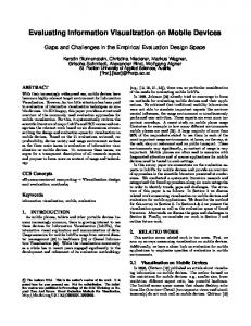
Tracking, Piloting and Navigating. Dead reckoning is where simple bearing and distance information is provided by the device, and followed using egocentric senses (for example internal kinaesthetic sense of distance moved). The information is of a very simple form, easy to memorise and follow, and requires little knowledge of the environment (Figure 1a), though of course it is error prone. In terms of completeness of information, the next approach is one of tracking – an allocentric approach whereby the information is taken from the environment, therefore requiring the user to identify features in the landscape. The task becomes more complex: perhaps to draw the user’s attention to signposts and turns, and includes a descriptive and confirmatory role (‘you should be at x’). The description of the route may be formed of a connected set of strip maps, connected at nodes of interest, or way-points (building on the city wayfinding model proposed by Lynch). A form of hypermapping would enable the user to move to finer levels of detail at key waypoints in the journey. Piloting, the third navigational strategy is a mix of egocentric (dead reckoning), and allocentric (tracking) strategies, and includes the presentation of information sufficient for the user to orientate themselves (Figure 1b). It can include text instructions such as ‘facing east, head to your left..’. The movement from landmark to landmark can also be combined with cardinal information.
2 Min to Hotel
3 N
S
5 mins Target
E
Main St.
2 3 mins
W
1 O
N
Turn right at the street intersection off Brooke St and onto Mitre Road. You will pass a church just after turning into Mitre Road.
6 mins
Tonal variation in sound conveys cardinal orientation
Band: 1/2 Mi, 15mins
(a) (b) (c) Figure 1 a) Dead reckoning information in the form of a ‘scope’ which conveys distance to target, and bearing to be walked to reach the centre.b) Piloting Bearing relative to a baseline feature and heading direction. c) A mix of communicative acts taking advantage of auditory and visual modalities.
The fourth strategy is a navigational strategy. In this instance it is the user who is empowered with information from which to select a route. In these instances the device must support high quality graphics, capable of zooming, panning, and rotation. Navigation requires the user to perform a set of key subtasks (namely alignment, positioning, and distance estimation) in order to navigate effectively. It is easy to imagine a mix of portrayals, strategies and media being used according to factors listed earlier. For example a tonal non-linguistic auditory act could be used to orientate the device, whilst a spoken description of the next key landmark could be given, during which the user reviewers how much further it is to travel (Figure 1c).
Communicative Acts Given the choice of strategies, richness of communicative acts (table 1) and other influencing factors it is necessary to devise a framework in which we can optimally combine different acts (graphical and auditory), in a co-ordinated manner, in order to convey specific information effectively. It is argued that conveying journey plan information can be conveyed as a set of hierarchically based communicative acts (similar to Maybury’s TEXPLAN system in which high level actions can be described in terms of more primitive illocutionary acts, which in turn can be described in terms of simple or ‘surface’ speech acts (Maybury 1992)). In following a prescribed route, it may be necessary for the device to perform a number of linguistic and graphical acts (table 1). LINGUISTIC GRAPHICAL NON-LINGUISITC AUDITORY ACTS Warn/exclaim highlight, blink, circle sound variation Inform indicate direction Assert display (zoom, pan) Recommend sequence, associate Table 1: A subset of communicative acts relevant to mobile devices (Maybury 1993). Navigating a route can be broken down into more primitive acts, each form of portrayal forming a piece of puzzle that forms a particular task within a set of constraints (ease of memorability, general affordance of device, user preferences). In broad terms the process of content planning through to actual presentation requires knowledge about the user (such as navigational preference), the task (such as time constraints), characteristics of the data (for example navigation in urban, or rural regions) and the media (such as the constraints of the device) – Figure 2. User characteristics
Content planning
Task characteristics
Presentation technique selection
Data characteristics
Presentation layout & coordination
Presentation
Media choice & Presentation Technique
Figure 2: Various knowledge sources providing input to content planning, and presentation (adapted from Roth and Hefley 1993). Maybury argues that the conceptual stages of content planning through to presentation can be formalised as plans, based on the ideas of Sacerdoti (1977) in which each plan operator defines constraints and preconditions, its intended effect and the decomposition of the acts into sub-acts. The example plan operator (Figure 3) could be one of several methods for performing the communicative action inform-location-visually. In the HEADER of the operator, the Identify act takes three arguments, device, user, and an entity. In essence the plan operator reads: Provided the third argument is a cartographic entity, and that the user wants to know the location of the entity from the device, and that
the device is capable of supporting graphic display, then the entity is made visible (the intended effect) by graphical display of the entity within the context of its local region. NAME inform-location-visually HEADER identify (device, user, entity) CONSTRAINTS cartographic-entity? (entity) PRECONDITIONS graphic-display (device) ^ wants(device, know(user, location (entity))) EFFECTS visible (entity) DECOMPOSITION display-region (entity) Figure 3: Plan operator for graphical display of current location When requesting location information, a unification program is required to identify all plan operators whose header portion matches the goal ‘request (device, user, entity). This is because there may be two or more plans with the same header. Because there may be more than one plan operator, it is necessary to have mechanisms that prioritise the plans (preference metrics). In this way we can model the preferences of the user. The order in which the plans are executed can minimise the number of steps taken by the user; this is important in a device of limited affordance. In essence the decomposition process shows the sub-tasks executed as part of plan instantiation. Conclusion Given the availability of mixed media in mobile devices, a framework is required for the optimal combination of communicative acts in order to efficiently support navigation/ execution of a given route. Using a combination of plans, and preference metrics, it is possible to combine a mix of visual and auditory acts in the presentation process (Figure 2). The constraints and preconditions of each plan can be used to model many of the factors listed at the outset, and form a framework in which we can select the most appropriate graphical forms in the knowledge that the stated goals will be achieved. References Maybury, M. T., 1992, Communicative Acts for Explanation Generation: International Journal of Man Machine Studies, v. 37, p. 135-172. Roth, S. F., and W. E. Hefley, 1993, Intelligent Multimedia Presentation Systems: research and principles, in M. T. Maybury, ed., Intelligent Multi Media Interfaces, Cambridge, Mass: AAAI Press/ MIT Press, p. 13-59. Sacerdoti, E. D., 1977, A Structure for Plans and Behaviors: New York, Elsevier NorthHolland. Maybury, M. T., 1993, Planning Multimedia Explanations Using Communicative Acts, in M. T. Maybury, ed., Intelligent Multi media Interfaces, California, AAAI Press/ MIT Press, p. 59-774. Hunt, E., and D. Waller, 1999, Orientation and wayfinding: A review ONR technical report N00014-96-0380, Arlington, VA: Office of Naval Research.