Developing a Decision Support System to Improve Transportation Planning in Landslide Prone Terrain Michael G. Wing Assistant Professor, Forest Engineering Department, Oregon State University, Corvallis, OR 97331, 541.737.4009,
[email protected], Fax: 541.737.4009 Elizabeth D. Coulter Graduate Student, Forest Engineering Department, Oregon State University, Corvallis, OR 97331, 541.737.3090,
[email protected] John Sessions Stewart Professor of Forest Operations, Forest Engineering Department, Oregon State University, Corvallis, OR 97331, 541.737.2818,
[email protected] ABSTRACT - Within the past decade, several transportation planning decision support systems that combine heuristic programming techniques with geographic information systems (GIS) technology have been developed to meet forest operation challenges. These decision support systems, however, have not directly addressed the upslope influences of landslides in choosing routes from road networks. This paper provides an overview of an on-going research project that seeks to develop a decision support system that takes slope stability into account when selecting transportation routes. The advancement of GIS and heuristic tools to assist planners in the location of transportation corridors may yield significant benefits in reducing short and long term costs associated with route selection and transportation networks. INTRODUCTION Transporting wood products from the forest to the mill is among the largest costs associated with wood production. Costs are usually divided between activities that are associated with forest roads including road construction, costs affiliated with operating and maintaining vehicles, and fixed and variable maintenance costs (Sessions 1986). Other influential factors include road network design and construction, network efficiency in meeting operation goals, and road maintenance. Usually, transportation planning methods have required forest engineers to use contour maps to identify combinations of route alternatives. These alternatives are then ranked on construction, transport, and maintenance requirements. While this method presents a feasible, yet labor intensive, method for smaller forested landscapes, larger areas pose significant challenges. These challenges may limit the ability of planners to develop a full set of alternatives and to choose from a set of alternatives in an efficient and timely manner. Past research efforts in forest operations and transportation planning have concentrated on individual route projection and evaluation. While these efforts have addressed gradients in locating road networks and optimal routes, they have typically not addressed whether routes on landslide prone terrain are being selected and they do not consider risk of slope failure. This paper describes an on-going project that is investigating the use of heuristic programming techniques and a GIS to create a decision support system for optimizing route selection based on topographic constraints. Our objective in this preliminary description of project efforts is to characterize the relative stability of a road network in steep terrain while accounting for the impacts of culverts and roads on hydrologic flow paths. In our initial tests, we have used a The International Mountain Logging and 11th Pacific Northwest Skyline Symposium 2001
56
formula that incorporates a topographic index to rate slope stability. We also discuss the potential for incorporating other constraints in the route selection process including road construction, transportation, and maintenance costs. When multiple constraints are considered, the use of optimization techniques in the creation of the decision support system could yield significant benefits in reducing short and long term costs associated with route selection and transportation networks. METHODS Our study area is the Elliott State Forest, located in the southern Oregon Coast Range and covering portions of Coos and Douglas counties. The Elliott is managed by the Oregon Department of Forestry (ODF), is approximately 376 km2 in size, and is an actively managed forest with an extensive road system of approximately 885 km. Major tree species include Western Hemlock (Tsuga heterophylla) and Douglas Fir (Pseudotsuga menziesii). Topography in the Elliott is typical of that found throughout the Coast Range; steep dissected terrain underlain by sedimentary geologies. The average slope in the Elliott, as developed from the digital terrain model described later in this paper, is 54 degrees with a standard deviation of 18 degrees. Elevations reach 640 m in portions of the forest. We obtained ArcInfo spatial data layers from the Elliott State Forest representing roads, streams, culverts, and a digital terrain model (DTM). These layers were created through a variety of methods. The road and stream data were originally derived from aerial photography. Culverts were located by Elliott State Forest staff who used the existing road and stream layers to reference culvert locations. Data for the DTM was originally derived from photogrammetric interpretation of stereo aerial photography. One artifact of this process is that locations free of canopy cover, such as roads, water bodies, and clearings were more heavily relied upon than other areas to create elevation points since ground elevations were visible to photo interpreters in these areas. This bias resulted in a set of elevation points that were non-uniformly distributed across the landscape. Elevation data for areas between photo-interpreted elevation points were interpolated by a kriging algorithm that mathematically attempted to create a uniformly distributed set of elevation points. This final product in this process is an elevation surface that has varying degrees of accuracy in its representation of elevation. Since many forms of elevation data are created from aerial photo interpretation, this outcome is typical for many DTMs. We transferred all vector data layers (roads, streams, and culverts) into a raster format so that all spatial data layers were in the same format and resolution as our raster-based DTM. A raster data structure involves dividing a landscape into equally sized square or rectangular blocks, called grid cells. The spatial resolution of our DTM was approximately 9 meters, meaning that each side of the raster-based DTM cells represented 9 m on the ground. We used a topographic index to represent the potential for soil saturation for each road grid cell in our study area. Although there were several indices that we could have employed, we used a topographic index that has been widely applied for hydrological and geomorphology modeling and that serves as the basis for the TOPMODEL catchment model (Beven and Kirkby 1979). The formula for calculating the topographic index is a / sin β where a represents a grid cell’s upslope contributing area per contour length, and β is the local slope of the grid cell. The topographic index is designed to predict the potential hydrologic flow The International Mountain Logging and 11th Pacific Northwest Skyline Symposium 2001
57
into each grid cell and to evaluate the potential of the grid cell’s surface to store or further transport flow. Through this index, areas of high saturation and potential source areas for runoff can be identified. The topographic index for each grid cell tends to increase as upslope contributing area increases. In contrast, the topographic index decreases as local slope increases. Grid cells that have the same value or range of values for a / sin β are expected to be similar hydrologically. Although index results cannot be directly linked to slope stability ratings without including additional parameters for precipitation and soil transmissivity, the index does provide a relative measure of soil saturation potential. We created the topographic index from the Elliott State Forest’s DTM after using a GIS to fill all sinks and create a continuous hydrologic surface. This procedure ensures that water is able to flow continuously and does not become trapped in a raster cell from which it can’t emerge. Upslope contributing areas for each raster cell were also calculated using a GIS. We used the spatial layer for roads and added a model constraint so that hydrologic flow paths could not cross over road locations. An exception to this constraint was that we did allow hydrologic flow to cross through roads if culverts (as indicated by our spatial layer for culverts) were present. We incorporated the topographic index into a factor of safety (FS) equation for roads in the Elliott Forest. The FS is based on the infinite slope stability model in which topographic, soil, and vegetative conditions of a landscape are assessed in determining the likelihood that a hillslope might fail. A FS value less than 0.5 indicates a slope that is more likely to fail, a FS value more than 0.5 signifies slopes that are less likely to fail. Our FS was calculated using a formula from Pack et al. (2000):
é æT a C + cosθ ê1 − minçç è R sin β ë FS = sin θ
ù ö ,1÷÷ wsr ú tan φ ø û
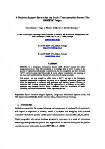
Where: C = soil cohesion θ = slope T/R = transmissivity ratio A/sin β = topographic index wsr = water/soil density ratio φ = internal soil friction angle In applying this equation, we assumed that soil cohesion, T/R, wsr, and the internal friction angle were uniform throughout the Elliott. The slope and topographic index parameter values varied according to local and upslope topography. RESULTS The factor of safety analysis was conducted for the roads within the Elliott State Forest. The magnitude of factor of safety results ranged between 0.26 and 3 with 3.5% of all roads having values in excess of 3. The places where FS values exceeded 3 were ridge locations and areas near shallow slopes. When these large FS values (> 3) were removed from the analysis results, an average FS of approximately 0.88 with a standard deviation of 0.47 resulted. The distribution of FS values is shown in Figure 1. The International Mountain Logging and 11th Pacific Northwest Skyline Symposium 2001
58
Distribution of Factor of Safety 120% 100% 15000 80% 60%
10000
40% 5000 20% 0 0
0.25 0.5 0.75
1 1.25 1.5 1.75 Factor of Safety
Cumulative Percentage of Road Cells
Number of Road Cells
20000
0% 2 2.25 2.5 2.75 Number of Cells Cumulative Percentage
Figure 1. Distribution of Factor of Safety values for road cells within the Elliott State Forest The FS values varied as expected, with road segments on ridge tops and in areas of mild slopes showing higher factors of safety (more stable). Combinations of large upslope contributing areas and high local slopes created the lower factors of safety (less stable), with the lowest value being equal to 0.26. DISCUSSION Our initial approach in assessing stability of a forested road system addressed upslope contributing areas and the potential influence of culverts and roads in intercepting hydrologic flow. Taking these considerations into account, we were able to assess the relative stability of roads within the Elliott Forest by calculating a FS value. Our results showed that the Elliott road network is relatively susceptible to slope failure. The most failure prone road segments appear to be mid-slope roads in steep terrain. The generation and distribution of FS values can act as a decision support system to assist transportation planning in forested landscapes by identifying network segments that are at higher probabilities of slope failure. By indicating those road segments that are most prone to failure, planners might seek to lessen or avoid road use in those areas, or justify research into developing additional networks. Goals in forest transportation planning typically include addressing road network design and construction, network efficiency in meeting operation goals, and road maintenance. Through heuristic programming, we plan to broaden our initial approach by incorporating additional constraints into our modeling process and expanding the ways in which variable parameters can be selected and adjusted to fit these planning goals. We envision two scenarios in which this approach might be employed. First, transportation planners might want to examine an existing road network to determine the relative stability of road surfaces and how to minimize costs that are associated with using the network for transporting timber. These costs could include maintenance activities, such as regrading or resurfacing. Costs might also be evaluated in terms The International Mountain Logging and 11th Pacific Northwest Skyline Symposium 2001
59
of potential impacts on other resources within the forest, such as aquatic habitat. This could involve minimizing road use in areas that are directly upslope of streams and have the potential to introduce sediment from road use or road failure directly into streams. Second, planners may want to consider the design of new road segments by using heuristics to identify potential road corridors that minimize travel distances and susceptibility to slope failure. In this approach, the entire forest landscape could be considered for potential road network development. Corridor alternatives could be evaluated based on their travel costs and road maintenance needs. Trade-offs in this process might involve developing road networks that don’t always feature the shortest travel distances between landings and mills, but might avoid potentially unstable terrain at the cost of travel efficiency. As road location and construction practices have been linked to increased landslide occurrences, some planners may choose to establish networks that minimize road length over the attainment of all other goals. ACKNOWLEDGMENTS The authors wish to acknowledge the support of the Center for Wood Product Utilization. REFERENCES Beven, K. J. and M.J. Kirkby. 1979. A physically based variable contributing area model of basin hydrology. Hydrological Sciences Bulletin 24(1):43-69. Pack, R.T., D.G. Tarboton, and C.N. Goodwin. 2001. Assessing terrain stability in a GIS using SINMAP. In proceedings: GIS 2001, February 19-22, Vancouver, British Columbia. Sessions, J. 1986. Can income tax rules affect management strategies for forest roads? Western Journal of Applied Forestry. 1(1):26-28. Sessions, J., J. C. Balcom, and K. Boston. 1987. Road location and construction practices: Effects on landslide frequency and size in the Oregon Coast Range. Western Journal of Applied Forestry, Vol. 2, No. 4. pp. 119-124. Swanson, F. J, L. E. Benda, S. H. Duncan, G. G. Grant, W. F. Megahan, L M. Reid, and R. R. Ziemer. 1987. Mass failures and other processes of sediment production in Pacific Northwest Forest Landscapes. In: Streamside management: Forestry and fishery interactions. E. O. Salo and T. W. Cundy, Editors. University of Washington Institute of Forest Resources Contribution No. 57, Seattle, Washington. P. 9-38.
The International Mountain Logging and 11th Pacific Northwest Skyline Symposium 2001
60