Applied Mechanics and Materials Vols. 519-520 (2014) pp 353-356 © (2014) Trans Tech Publications, Switzerland doi:10.4028/www.scientific.net/AMM.519-520.353
Differences in visual programming for GIS Zdena Dobesova1, a, Petr Dobes2,b 1, 2
Department of Geoinformatics, Faculty of Science Palacký University, Olomouc, Czech Republic
a
[email protected], b
[email protected]
Keywords: GIS, visual programming languages, ModelBuilder, ArcGIS, AutoCAD Map, data flow.
Abstract. ArcGIS and AutoCAD Map 3D are both geographic information system (GIS) software. Both are used worldwide in many countries and companies. The dataflow design in visual editors is suitable for daily work. Visual languages are valuable for wide user community. Dataflow design automatizes typical GIS tasks and makes the processes universal. It is possible to construct simple or complex workflows with a visual editor in both software. The concept of visual programming is highly acceptable for GIS users because they think spatially and graphically. The article presented practical example for automatic finding of suitable area for construction of new hotel. Two data flow diagrams for the same task demonstrate the differences between graphical notations in ArcGIS and AutoCAD Map. Introduction Graphical data flow diagrams are used for the expression of the data flow processing in geographic information systems (GIS). Data flow diagrams belong to the sort of visual programming languages. The dataflow diagrams in GIS are primarily focused in this article. The first is ArcGIS software from Esri Company. It offers a possibility to design the steps of data processing in the graphic editor ModelBuilder. This editor is an embedded base component of ArcGIS for Desktop. The philosophy is an easy way to draw data flow diagram. ModelBuilder belongs to the family knows as visual programming languages or a diagrammatic programming or dataflow programming. Many students and experienced users of ArcGIS can assemble data flow diagram in ModelBuilder for repetitive processing [1]. The second experience is AutoCAD Map 3D by Autodesk company in the field of visual programming for GIS. This software also offers an embedded component named Workflow Designer. Both visual components are given lessons at learning of the study program “Geoinformatics” at Palacký University. Finally, the visual programming is used for realization of practical projects in diploma theses and research projects. Both graphical components, ModelBuilder and Workflow Designer, are based on ideas of visual programming. The core programming paradigm is that a visual program is a directed graph where the data flowing between operations. Basic graphic symbols are boxes and arrows. Data flow is designed graphically based on connecting boxes and arrows. Boxes represent spatial functions and arrows indicate the orientation of data flow. All graphical elements can be manipulated by users in an interactive way. New elements are simply dragged and dropped from basic container. The beginning of using of both components is quick for users. Comparison example Next part of article present example of the same spatial analysis and its realisation as data flow chart in two previously presented components for visual programming. The aim is to find a suitable area for building a new hotel. The first condition is that the distance from main roads must be smaller than 2 500 metres. The second condition is that the existing hotels of the same owner must be far away than 2 500 metres. All rights reserved. No part of contents of this paper may be reproduced or transmitted in any form or by any means without the written permission of TTP, www.ttp.net. (ID: 158.194.94.39-31/01/14,18:24:43)
354
Computer and Information Technology
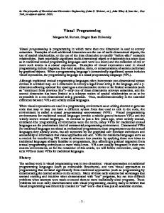
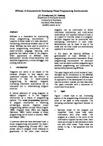
The example operates with two input feature classes (existing hotels and Roads). Buffer zones are created for both feature classes. Overlay operation - Erase of both buffers finished task. Final compound polygon can be displayed as a result of analysis (Fig. 1). These partial steps (buffer of roads, buffer of hotels and overlay - erase) are better consisting as data flow diagram then execute them manually by separate function. The advantage is also repetitive using of the diagram for another data for the same task – finding suitable area for new hotels. Next two figures show two data flow chart. Fig. 2 shows data flow chart in ModelBuilder. Two horizontal lines for processing two input feature classes can be seen. Final yellow Erase box connects two lines and produces one green output feature layer. Fig. 3 shows data flow chart in Dataflow Designer. Data flow consists from nine boxes. The last grey box contents the picture that explains the operation of Erase.
Figure 1. Result map for finding a suitable area
Figure 2. Model for finding suitable area for building a new hotel (ModelBuilder) Main Differences There is the first big difference between ModelBuilder and Workflow Designer. The green start sign and the red end sign are in the Workflow Designer. These signs are missing in ModelBuilder. The process starts on the left side from the top. It is partially evidence from oriented arrows. The next difference is in a predominant orientation. Workflow Designer allows only top-down orientation. The ModelBuilder allows both orientations: top-down and left-right orientation. Left – right orientations are preferred. User sketch can be drawn quickly with skewed arrows in different angles without aligning graphical elements. Automatic arrange of graphic element is set by clicking on Auto Layout button. By this automatic align, the main orientation is remake to the left- right orientation. From the point of graphical elements, the ModelBuilder in ArcGIS uses the different shapes and colors and different color for graphical elements (yellow rectangles for functions, blue/green ovals for data). Detailed descriptions of notation are in [2, 3, 4]. The Workflow Designer uses only rectangles. Rectangles express the input, output data and function in one rectangle. All information are listed in
Applied Mechanics and Materials Vols. 519-520
355
rectangle graphical element by text and sometimes by illustrative graphics. The elements of graphic notations differ evidently for that two GIS software.
Figure 3. Workflow for finding suitable area for building a new hotel (Workflow Designer) Principles of Physics of Notation The principles of “Physics of Notation” by Daniel Moody can be applied for evaluation of the graphical notation for visual languages [5]. Moody suggested nine principles: Semiotic Clarity, Perceptual Discriminability, Visual Expressiveness, Semantic Transparency, Dual Coding, Graphic Economy, Cognitive Integration, Complexity Management and Cognitive Fit. Evaluation of notation for ModelBuilder according to the Moody`s “Physics of Notation principles is presented in the article by Dobesova [6]. Semiotic Clarity is the base principle. The ModelBuilder is better from the point of Semiotic Clarity. The rectangle symbol in the Workflow Designer is overloaded. Only one symbol – rectangles used for more constructs (semantics). The same shape rectangle is used for function Add Feature Layer, Create Buffer, Perform Overlay etc (Fig. 3). Next principle is Perceptual Discriminability. The discriminability of graphical elements is better in ModelBuilder than in Workflow Designer. Graphical elements differ in shapes and colors (yellow, green, blue). The small icon in left upper corner helps for the discriminability in ModelBuilder (Fig. 4).
356
Computer and Information Technology
Figure 4. Example of graphical element in Workflow Designer The next Moody`s principle is the principle of Dual Coding. This principle recommends using text to complement graphics. The comparison of ModelBuilder and Workflow Designer results better evaluation for Workflow Designer from that point. The description of performed function is in several text rows (Fig. 4). The first is bold text with the name of the operation. Next lines of text contain e.g. name of data, parameters and its values (Distance: 2500), type of operation. In same cases, the rectangle contains the small graphic at the bottom that explains the type of operation (e.g. Erase in Fig.4). All these inner information can be considered as dual coding. The information is listed automatically by graphic editor. The dual coding by text in ModelBuilder is weaker. The text is changeable by the user. User manually added information about the distance as the label of yellow tools Buffer Road (Distance 2500). The dual text notation in ModelBuilder must be created manually and depend on skills of users and his knowledge how improve graphical notation by dual coding. Conclusions The ArcGIS ModelBuilder is free in graphical design and more powerful in functionality. The graphical notation partially follows some principles of “Physics of Notation”, especially Semiotic Clarity. The AutoCAD Map Workflow Designer remarkably fulfills the principle of Dual Coding. This text dual coding prevents errors in diagrams and human perception. Acknowledgement Work was supported by the project CZ.1.07/2.3.00/20.0166. References [1] Dobesova, Z. Programming Language Python for Data Processing. Proceedings of International Conference on Electrical and Control Engineering (ICECE), Yichang, China, 2011, IEEE, CFP 1173J-PRT, Volume 6, pp. 4866-4869. ISBN 978-1-4244-8163-7. [2] Dobesova, Z. Visual programming for novice programmers in geoinformatics, in 12th International Multidisciplinary Scientific GeoConference. 2012: Bulgaria, Albena. p. 433- 440. [3] Dobesova, Z., Dobes, P. Comparison of visual languages in Geographic Information Systems. In IEEE Symposium on Visual Languages and Human-Centric Computing. Innsbruck. 2012. [4] Dobesova, Z. Visual programming language in geographic information systems. In Recent Researches in Applied Informatics, 2nd International Conference on Applied Informatics and Computing Theory, AICT 11. 2011. Prague: NAUN/IEEE, WSEAS Press. [5] Moody, D.L., The "Physics" of Notations: Toward a Scientific Basis for Constructing Visual Notations in Software Engineering. IEEE Transactions on Software Engineering, 2009. 35(6): p. 756-779. [6] Dobesova Z. Using the “Physics” of Notation to Analyse ModelBuilder Diagrams. SGEM 2013 13th International Multidisciplinary Scientific GeoConference, Proceedings Volume I STEF92 Technology Ltd. Sofia, Bulgaria, 2013, p. 595–602.