Embedding Google Maps APIs into WebRatio for the Automatic Generation of Web GIS Applications Giuseppe Avagliano1, Sergio Di Martino2, Filomena Ferrucci1, Luca Paolino1, Monica Sebillo1, Genoveffa Tortora1, and Giuliana Vitiello1 1
Dipartimento di Matematica e Informatica (DMI), University of Salerno, Via Ponte Don Melillo, I-84084 Fisciano (SA), Italy {fferrucci,lpaolino,msebillo,tortora,gvitiello}@unisa.it 2 University of Naples “Federico II”, via Cinthia, I-80126 Napoli, Italy
[email protected]
Abstract. The success of WebML (Web Modeling Language) and of the supporting tool WebRatio for designing and generating data-intensive web applications suggested us to extend the approach to the Web GIS context. The proposal was based on Geo Server and Map Server, two standard, open solutions, to handle spatial data. In the present paper, we propose an alternative approach based on Google Maps, a freely available web mapping application provided by Google, which allows for the search and the visualization of geographic information. This solution is so diffuse that many Internet users are identifying it as a “standard” way for the presentation of geographical information. Moreover, Google Maps can be integrated into a Web application by exploiting Google Maps APIs. In the paper, we describe the proposed WebMLbased visual language to design Web GIS applications and how it has been embedded into WebRatio to generate Web GIS applications by exploiting the potentialities of the Google Maps APIs. We also illustrate the architecture of the generated Web GIS applications together with the employed technologies and provide a sample example of design and generation of a Web GIS application.
1 Introduction Recently, the increasing popularity of Rich Internet Applications has led to the development of Web applications, known as Web GIS, intended for dissemination and manipulation of spatial knowledge in specific domains. Compared with traditional Geographic Information Systems (GIS) [9, 10], Web GIS hold the potential to make geographic information available to a worldwide audience, allows Internet users to access GIS applications from their browsers without purchasing proprietary GIS software, and makes it possible to add GIS features to a wide range of network-based applications in business, government, education, etc. [12, 13]. However, software environments supporting the development of Web GIS applications are very hard to use and require specialized skill. Moreover, with the increased time-to-market pressure, it is no longer possible to deal with low-level issues, and create Web GIS applications from scratch. Thus, there is a growing need M. Sebillo, G. Vitiello, and G. Schaefer (Eds.): VISUAL 2008, LNCS 5188, pp. 259–270, 2008. © Springer-Verlag Berlin Heidelberg 2008
260
G. Avagliano et al.
for tools that allow developers to rapidly create this kind of Web applications and to rapidly modify them to meet the ever-changing business needs. For traditional Web applications, many solutions are currently available. Among them, the WebML (Web Modeling Language) approach is based on a high-level, formal visual language specifically conceived to design “data-intensive” Web applications [1, 2, 13], which rely mainly on data management and movements. The approach is effectively supported by a CASE tool, WebRatio [1], which allows for the automatic generation of Web applications starting from a WebML visual specification. The approach has been successfully applied in many different contexts, from industry to academia, with positive results. The observation that Web GIS can be considered as a particular class of dataintensive Web applications, being mainly devoted to handle (spatial) information, suggested us to extend the WebML methodology to deal with the Web GIS context. Indeed, the aim is to realize a visual environment that allows designers to model the required Web GIS application by spatially manipulating visual metaphors and then translates such visual schema into a self-contained application. Preliminary results were introduced in [3-6]. The main contribution was a set of customized visual elements (units) specifically conceived to model relevant interaction and navigation operations, which usually characterize Web GIS (known as web mapping functionality). Moreover, the WebRatio CASE tool was enhanced to generate Web GIS applications by implementing the introduced units for the GISspecific functionalities, and by exploiting the two standard open solutions Geo Server and Map Server for spatial data management. In the present paper, we propose an alternative WebML-based approach to the generation of Web GIS applications. The new solution leverages on Google Maps [8] (GM in the following), a freely available Web mapping application, which allows the search and the visualization of geographic information, by seamlessly interacting with a smart user interface. Some of the most important advantages coming from the adoption of GM are the constant update of the geographical data (e.g.: roads), the appealing user interfaces, which exploits the most advanced Web technologies and counterbalances typical browser limitations, such as the use of a contextual right click, the use of the scroll wheel to zoom in/out, etc… Another advantage derives from the diffusion of GM. In fact, its widespread adoption by Internet users has made GM a de facto standard for presenting geographic information. This spreading is also due to the Google licensing policy which allows developers to freely integrate GM in their applications, through the Google Maps APIs [7]. These APIs provide a number of utilities for manipulating maps and adding content to them through a variety of services. These observations motivate the approach we propose in this paper. The WebMLbased visual language has been enriched by introducing new customized units devoted to handle properties and components specific of GM, such as the GM viewer and the map type, which can be map, satellite or hybrid. Moreover, by exploiting potentialities of GM APIs the new customized units have been embedded into WebRatio, thus obtaining the automatic generation of the modeled Web GIS application. The remainder of the paper is organized as follows. Section 2 recalls the main concepts of WebML and GM. In Section 3 we describe the proposed modeling concepts and notations which extend WebML for Web GIS applications. The architecture of the WebGIS applications generated by the WebRatio tool and the
Embedding Google Maps APIs into WebRatio
261
employed technologies are described in Section 4. In Section 5 we present an example of use of the proposed approach, while some final remarks conclude the paper.
2 Preliminaries The solution we propose exploits both the expressiveness of WebML in describing a development process and the exhaustiveness of the GM APIs in realizing a WebGIS application. By integrating such capability within a homogeneous framework, we have extended WebRatio, obtaining a CASE tool able to provide developers with a visual environment to design and implement Web GIS applications. In the following we recall some basic notions of WebML and GM APIs useful to describe the extension we propose. 2.1 WebML: A Modeling Language for Web Applications WebML is a modeling language suited to support users in designing data-intensive Web applications [2], by providing them with a set of visual notations to model the content structure, data, and navigational aspects of a Web application. The design of a Web application is based on two orthogonal perspectives: data and navigation. The former is usually described by means of the well-known ER data model, which characterizes all the relevant entities and relationships. The latter is specified by the WebML Hypertext Model, which describes how the previously defined contents should be arranged and provided within the Web application. In particular, the application structure and appearance are defined through four main levels of abstraction: site views, areas, pages and units. Moreover, semantics and syntax of notations allowed WebML creators to propose a specifically conceived commercial CASE tool, WebRatio, which automatically generates a J2EE-based Web application starting from the corresponding design models, thus effectively reducing time and costs of software development. In [3-6] we proposed an extension of both WebML and WebRatio meant to support designers in generating Web-based GIS applications, which deal with complex, expensive and voluminous geographic data. In particular, recognizing Web GIS applications as a special case of data-intensive Web systems suggested us to employ the WebML approach to define a development process which took into account the complex nature of geographic data. Moreover, we introduced new ad hoc units, capable to model functionality, which characterizes those applications. 2.2 Google Maps and Its APIs Google Maps [8] is a freely available web mapping application provided by Google that allows the search and visualization of geographic information. It provides both geo-referenced satellite images and vector maps, enhanced by a number of additional informative layers, related to points of interest such as restaurants, monuments and hotels. Moreover, GM can generate driving directions between any pair of locations. The integration of many state-of-the-art web technologies, like Ajax, within the GM user interface has led to a smart and easy interaction, which involves the drag&drop mechanism for moving/selecting items, the scroll wheel to zoom in/out,
262
G. Avagliano et al.
the drag of a map for panning, and the double click to zoom and center the viewpoint. It is worth noting that all these metaphors are widely accepted for traditional desktop applications, but their diffusion in Web applications is very limited, due to wellknown technical difficulties. Finally, in order to improve the reactivity of the application to the user panning, GM splits a map into a set of tiles that are smartly pre-cached. From a development point of view, Google licensing policy allows web application developers to integrate GM in their sites, through the GM APIs [7]. These APIs provide a set of utilities for manipulating maps and adding content to them through a variety of services.
3 Extending WebML for Web GIS Applications Exploiting WebML for modeling Web GIS applications first implies the extension of the underlying visual language by defining new visual metaphors. In fact, besides the common interactions users may perform when navigating and executing a web application, it is necessary to take into account actions users may perform when interacting with a map, such as zooming, panning and spatial selection. Those actions are peculiar and characterize Web GIS applications. The WebML extension we propose provides a new set of units, specifically conceived to model users’ interaction with a map browser, where basic functionality for navigating and searching within a GM viewer is supplied. In the following, we describe those units and illustrate their main properties.
Fig. 1. The Icon we choose to represent a MultiMap Unit within WebRatio
The MultiMap Unit Basically, the MultiMap Unit is a unit meant to represent the GM viewer, i.e. a graphic component within a Web browser able to render geographical data arranged
Embedding Google Maps APIs into WebRatio
263
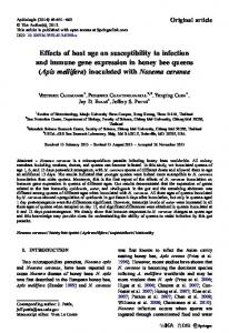
Fig. 2. How a MultiMap (Left), a MapControl (Right), appear within a Web browser
in layers. Fig. 1 illustrates the icon of a MultiMap Unit instance, namely TheMap, while its representation resulting in a Web browser is shown in Fig. 3 (Left). This unit is characterized by the following properties: -
-
-
-
-
-
-
-
Name: The name chosen by the WebGIS designer for the MultiMap Unit instance; o Type: STRING; o Mandatory: YES; CenterX: The X coordinate of central point of the map; o Type: INT; o Mandatory: YES; CenterY: The Y coordinate of central point of the map; o Type: INT; o Mandatory: YES; Width: The width of the map control within the web page, in pixels; o Type: INT; o Mandatory: YES; Height: The height of the map control within the web page, in pixels; o Type: INT; o Mandatory: YES; ZoomFactor: The zoom level used the first time the map is rendered. It can be set in a range of values, from 0 (World View) to 16 (Street View). o Type: INT in [0..16]; o Mandatory: NO; Scale: A parameter the developer can use to show a Scale Unit onto the map; o Type: Boolean; o Mandatory: NO; Default = OFF MapControl: A parameter the designer can use to add a control onto the map to zoom in, zoom out, move and re-center the initial map. Its representation in the web browser is shown in Fig. 3 (Right).
264
G. Avagliano et al.
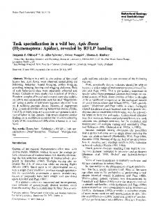
Type: Enumeration with the following values: OFF (Default), Small, Large; o Mandatory: NO; MapType: A parameter the designer can use to add a selection of the map type, i.e. it can be used to set the kind of map view, such as Satellite, Terrain, Streets, and so on. The default configuration results in a set of three buttons, as shown in Fig. 3 (Left). o Type: STRING. The various types must be concatenated by means of a semicolon (e.g.: Satellite; Streets;). o Mandatory: NO; Overview: A parameter the designer can use to add an overview map within the main GM viewer. It is meant to orient users by showing the location of the current view in the context of a larger area. Its representation in the web browser is shown in Fig. 3 (Right). o Type: Boolean; o Mandatory: NO; Default = OFF Scroll Wheel Zoom: A parameter the developer can use to enable or less the Zoom via mouse scroll wheel; o Type: Boolean; o Mandatory: NO; Default = OFF Google Key: The licensing key associated with the domain. It can be freely available, once activated a Google account. o Type: STRING; o Mandatory: YES; o
-
-
-
-
Fig. 3. How a MapType (Left) and an Overview (Right) appear within a Web browser
The Marker Unit This Unit is meant to highlight onto the map one or more locations, starting from their real address. To this aim, it generates a web form, allowing the user to input the address. Once submitted, if such address exists, it is evidenced onto the map via a pinpoint. Thus, starting from a toponym, the Marker Unit allows converting it into a geographic reference and locates it on the map.
Embedding Google Maps APIs into WebRatio
265
Fig. 4. An instance of a Marker Unit (Top) and its representation in a Web browser (Bottom)
In WebML, this unit requires a web form which allows the user to enter the address of the point of interest that may be possibly stored in the database. Fig. 4 (Top) shows how an instance of the Marker unit is specified within WebRatio, while the visual representation of the generated HTML code is depicted in Fig. 4 (bottom). Please note both the Form the user can exploit to specify the address (in the upper right corner), both the marker highlighting it onto the map. The GetDirection Unit The GetDirection Unit (see Fig. 5(Top)) allows us to calculate a route path between two addresses, and to highlight it onto the map. To this aim, it generates a web form to allow the user to input the two addresses required for the path. In order to improve its flexibility, we have contemplated also the possibility that the designer can set one of the two points. For instance, a developer of a Hotel web site could specify as destination point the lodge address, to generate a web page like “Insert your address to reach us”. The GetDirection Unit is characterized by the following parameters: -
Name: The name chosen by the WebGIS designer for the GetDirection Unit instance; o Type: STRING; o Mandatory: YES;
266
G. Avagliano et al.
-
-
-
-
Departure: The address of the starting point. o Type: STRING; o Mandatory: NO; Arrival: The address of the destination point. o Type: STRING; o Mandatory: NO; Unit: It specifies whether distances are shown in the imperial or in the metric scale unit. If not specified, distances will be indicated according to the system adopted by the starting country. o Type: Enumeration with the following values: KM, Miles; o Mandatory: NO; Avoid Highways: It specifies whether considering toll roads in the route calculation or not; o Type: Boolean; o Mandatory: NO;
The calculated path is overlapped to the map, as depicted in Fig. 5 (Bottom), while the set of turn-by-turn indications to follow is reported in a separated DIV of the web page.
Fig. 5. The GetDirection Unit (Top) and its representation in a Web browser (Bottom)
Embedding Google Maps APIs into WebRatio
267
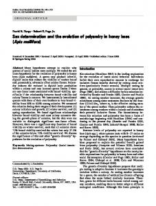
4 The Generated Web GIS Applications: The Architecture and the Underlying Technologies Once basic WebML units necessary for developing Web GIS applications have been designed, they have been implemented in WebRatio to support designers in the automatic code generation and delivering phases of Web applications. In particular, the tool generates the server side code, which handles and solves requests submitted via the Internet trough the Web browser. Fig. 6 depicts the employed technologies and the architecture of a Web GIS application generated through WebRatio. The application is based on a three-tiered architecture and on a set of protocols and open technologies, such as Apache/Tomcat, Ajax and GM APIs, which guarantee the integration and interoperability between server modules and the client browser. Basically, the WebML units are translated into JSP pages and/or Servlet modules and successively mounted as a Tomcat/Apache web application. When users connect to a Web GIS, an automatic request is forwarded to the GM Server in order to receive maps to be displayed. This specific task will be automatically performed by the JavaScript code integrated within the downloaded web application. As for navigation and searches, users’ actions are translated into Ajax requests and then sent to the GM servers. They select data satisfying the request and sent back client HTML and JavaScript code, as well as new raster data to update the displayed map. Finally, in order to manage markers, a database is included on the Web GIS server side which stores both coordinates and description associated with them.
Fig. 6. WebRatio visual environment and the architecture of a generated Web GIS application
268
G. Avagliano et al.
5 An Example In order to prove the effectiveness of the proposed solution, in this Section we describe the design accomplished to realize a Map feature of our department Web site. In particular, we illustrate the WebML-based schema which contains both units provided by original WebRatio version and new units implemented through the extended version. As for the Hypertext & Web Mapping design, the specific section of the web site is made up of two pages, as shown in Fig. 7: -
-
A Home page that contains the External Link instance of the Index unit meant to specify the external link to the other pages of the web site. Among them, one is pointing to the Map Page. A Map Page containing the TheMap instance of the MultiMap Unit, the Marker instance of the Marker Unit and, finally, GetDirection1 instance of the GetDirection Unit.
Once generated, the Web GIS application provides the panning and zooming functionality, the map control buttons, the button for the visualization of the map type and the overview of the map. Moreover, users may insert and fix markers on the map through the Insert Marker link. Once a marker is attached, it is possible to click on it and visualize a dynamic form, as shown in Fig. 8. Finally, through the GetDirections button, it is possible to calculate the route path connecting any arbitrary address (the city of Salerno in our example) and the campus of the University of the Salerno or vice versa. The result of this operation is visualized as both a polyline on the map and a list of turn-by-turn indications.
Fig. 7. The WebML-based schema for the proposed example
Embedding Google Maps APIs into WebRatio
269
Fig. 8. The UI of the generated WebGIS application
6 Conclusions In the present paper, we described an approach for designing and generating Web GIS applications that synergically combines the advantages of WebML/WebRatio and GM. In particular, we defined some visual notations to deal with web mapping functionalities and we embedded them into WebRatio by exploiting the potentialities of the GM APIs. The effectiveness of the proposed approach has been shown by exemplifying the modeling and construction of a Web GIS application. As future work we plan to extend this solution by allowing developers both to select the required mapping service during the automatic generation task and to embed users own data to visualize. Indeed, it is worth to noting that currently other mapping services, such as Yahoo Maps [14], Microsoft Live Search Maps [11], are available over the Web, which share the same GM advantages. On the other side, it could be very useful for designer to show their own geographical data onto the map.
Acknowledgements The authors wish to thank Dott. Giacomo Petillo for his support in the development of the solution proposed in this paper.
References 1. Ceri, S., Fraternali, P., Bongio, A., Brambilla, M., Comai, S., Matera, M.: Designing DataIntensive Web Applications. Morgan-Kaufmann Publishers, San Francisco (2002) 2. Ceri, S., Fraternali, P., Bongio, A.: Web Modeling Language (WebML): a Modeling Language for Designing Web Sites. Computer Networks. The International Journal of Computer and Telecommunications Networking 33(1-6), 137–157 (2000)
270
G. Avagliano et al.
3. Di Martino, S., Ferrucci, F., Paolino, L., Sebillo, M., Tortora, G., Vitiello, G., Avagliano, G.: Towards the Automatic Generation of Web GIS. In: Proc. of the 15th International Symposium on Advances in Geographic Information Systems (ACMGIS 2007), Seattle USA, pp. 7–9 (November 2007) 4. Di Martino, S., Ferrucci, F., Paolino, L., Sebillo, M., Vitiello, G., Avagliano, G.: A WebML-based visual language for the development of Web GIS Applications. In: IEEE Proceedings of the 2007 Symposium on Visual Languages and Human-Centric Computing (VL/HCC 2007) IEEE Press. Coeur d’Alene, Idaho, USA, pp. 23–27, 209–212 (September 2007) 5. Di Martino, S., Ferrucci, F., Ginige, A., Paolino, L., Sebillo, M., Vitiello, G., Avagliano, G.: A method to develop Web GIS. In: Proceedings of the International Workshop on Visual Languages and Computing (VLC 2007), San Francisco, California, USA, pp. 6–8, 229–234 (September 2007) 6. Di Martino, S., Ferrucci, F., Paolino, L., Sebillo, M., Vitiello, G., Avagliano, G.: A WebML-based Approach for the Development of Web GIS Applications. In: Benatallah, B., Casati, F., Georgakopoulos, D., Bartolini, C., Sadiq, W., Godart, C. (eds.) WISE 2007. LNCS, vol. 4831, pp. 385–397. Springer, Heidelberg (2007) 7. Google Maps APIs website, http://code.google.com/apis/maps/ 8. Google Maps website, http://maps.google.com 9. Longley, P.A., Goodchild, M.F., Maguire, D.J., Rhind, D.W.: Geographic Information Systems and Science, p. 472. Wiley, Chichester (2001) 10. Longley, P.A., Goodchild, M.F., Maguire, D.J., Rhind, D.W.: Geographical Information System Principles, 2nd edn. Wiley, Chichester (2001) 11. Microsoft Maps Live, http://maps.live.com 12. Peng, Z., Tsou, M.: Internet GIS – Distributed GIServices for the Internet and wireless networks. Wiley, Chichester (2003) 13. WebML site, http://www.Webml.org 14. Yahoo Maps, http://maps.yahoo.com/om