Purves, D., Lotto, R.B.: Why we see what we do: An empirical theory of vision. ... hot pink pale green lilac beige lavender olive light green light blue sky blue red.
MapSets: Visualizing Embedded and Clustered Graphs Alon Efrat, Yifan Hu, Stephen G. Kobourov, and Sergey Pupyrev Department of Computer Science, University of Arizona, Tucson, AZ, USA Abstract. We describe MapSets, a method for visualizing embedded and clustered graphs. The proposed method relies on a theoretically sound geometric algorithm which guarantees the contiguity and disjointness of the regions representing the clusters, and also optimizes the convexity of the regions. A fully functional implementation is available online and is used in a comparison with related earlier methods.
1
Introduction
In many real-world examples of relational datasets, groups of objects (clusters) are an inherent and important part of the input. For example, scientists belong to specific research communities, politicians are affiliated with specific parties, and living organisms are divided into biological species in the tree of life. Such clusters are often visualized with regions in the plane that enclose related objects. By explicitly defining the boundary and coloring the regions, the cluster information becomes evident. In many instances the data objects are often associated with fixed or relative positions in the plane. In geo-referenced data, for example, the positions of the objects might be based on their geographic coordinates. Thus a natural problem arises: how to best visualize graphs in which vertices are divided into clusters and embedded with fixed positions in the plane? Several existing visualization approaches seem suitable. For example, methods for visualizing set relations over existing embedded pointsets, such as BubbleSets [7] and LineSets [2] use colored shapes to connect objects that belong to the same set. Alternatively, a geographic map metaphor can be used to represent such data. With selforganizing maps [22] or geometry-based GMaps [11], objects become cities and cluster information is captured by uniquely colored countries. While both approaches can produce compelling visualizations, we argue that neither is perfectly suited to the problem of visualizing embedded and clustered graphs. As the number of sets increases, set-based methods generate very complex and sometimes ambiguous results. More recent methods such as KelpDiagrams [8] and KelpFusion [16] reduce visual clutter and guarantee unambiguous visualization. But more importantly, all of these methods result in overlapping regions for the sets, even when the input sets are disjoint. This unnecessarily increases visual complexity and might mislead the viewer about the disjointness of the sets. The geographic map approach suffers from a different problem. A country in the map, that represents a given cluster of vertices, might not be a contiguous region in the plane. Even though each cluster is colored with a unique color, such fragmented maps are difficult to read as human perception of color changes based on surrounding colors [19] and can be misinterpreted [13].
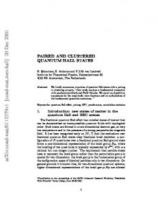
(a)
(b)
(c)
Fig. 1: (a) An embedded and clustered (red/blue) pointset. (b-c) Two different ways to construct contiguous shapes bounding points of the same color.
We want to combine the advantages of both methods, while attempting to avoid their problems. That is, we are interested in visualizing embedded and clustered graphs with non-fragmented and non-overlapping regions. While constructing such representations is easy in theory, in practice the regions may still have high visual complexity; see Fig. 1. Ideally the regions should be as convex as possible, as the convex hull best captures cohesive grouping according to Gestalt theory [14]. With this in mind, we describe MapSets, method for creating non-fragmented, nonoverlapping regions that are as convex as possible, from a given embedded and clustered graph. We consider several criteria for measuring convexity of a given shape, and propose a novel geometric problem aiming at optimizing convexity. We include a theoretical analysis of the problem in Section 3, including a computational hardness and an approximation algorithm. Next, in Section 4, we provide a practical method for visualizing clustered graphs, which relies on the theoretical algorithm and guarantees contiguity and disjointness of the regions, and also optimizes the convexity of the regions. A fully functional implementation is available in an online system and is used in a comparison with existing techniques, which we present in Section 5.
2
Related Work
We review work related to the practical and theoretical aspects of the problem of visualizing embedded and clustered graphs. Set Visualization: Graph clusters can be viewed as sets over graph vertices. In Venn diagrams and their generalization, Euler diagrams, closed curves correspond to (possibly overlapping) sets, and overlaps between the curves indicate intersections. Simonetto et al. [21] automatically generate Euler-like diagrams, by allowing disconnected regions, which can be complex and non-convex. Riche and Dwyer [20] propose a way to avoid the visual complexity problem by drawing simplified rectangular Euler-like diagrams, that do not depict the intersections between the sets explicitly, by duplicating objects that belong to multiple sets. In a user study, they found that it is beneficial to show intersections using simple set regions and strict containment, enabled by the duplication. For the setting where the positions of the objects is fixed, Collins et al. [7] present BubbleSets, a method based on isocontours to overlay such an arrangement with enclosing set regions. The readability of these visualizations suffer when they are many overlapping regions. LineSets [2] aim to improve the readability of complex set intersections and to minimize the overall visual clutter by reducing set regions to simple curved lines drawn through set elements. KelpDiagrams [8] incorporate classic graphdrawing “bubble and stick” style graph or tree spanners over the member points in a 2
set. KelpFusion [16] adds filled-in regions to provide a stronger sense of grouping for close elements. A significant limitation of all these set visualization techniques is that they produce overlapping regions even when the sets are disjoint. Visualizing Graphs as Maps: The geographic map metaphor is utilized as visual interface for relational data, where objects, relations between objects, and clustering are captured by cities, roads, and countries. Using maps to visualize non-cartographic data has been considered in the context of spatialization by Fabrikant et al. [10]. Self-organizing maps, coupled with geographic information systems, render 2D maps of textual documents [23], which provide an adaptable set of tools for spatial visualization of large document collections. Maps of science showing groups of scientific disciplines are used by a wide range of professionals to grasp developments in science and technology [5]. One drawback is that self-organizing maps are very computationally expensive. The geographic map metaphor is used in the Graph-to-Map approach (GMap) [11]. GMap combines graph layout and graph clustering, together with appropriate coloring of the clusters and creating boundaries based on clusters and connectivity in the original graph. However, since layout and clustering are two separate steps, a region representing a cluster may often be fragmented; see Fig. 7(b). Such fragmentation makes it difficult to identify the correct regions and can result in misinterpretation of the map [13]. Colored Spanning Trees: From an algorithmic perspective, our geometric approach of optimizing convexity of regions that cover points in the plane is related to several computational geometry problems. In many problems the input is a multicolored point set, like red-blue intersection, separation, and connection problems [1,3]. Also related is the group Steiner tree problem where, for a graph with colored vertices, the objective is to find a minimum weight subtree covering all colors [17]. Also related is the problem of computing spanning graphs for multicolored point set [12]. The problem is motivated by optimizing the amount of “ink” needed to connect monochromatic points that arise when visualizing sets using the KelpFusion technique. These trees cannot be directly used as “skeletons” of regions in the plane as they can result in overlapping regions.
3
Constructing Contiguous Non-Overlapping Regions
We assume that the input instance consists of a set of objects P with fixed positions pi ∈ R2 for all i ∈ P , for example, cities and their geographic locations. In practical applications labels are often associated with the objects. In this case, we assume that non-overlapping bounding boxes for every label are given. The input also specifies a clustering C = {C1 , . . . , Ck } of the objects with ∪ki=1 Ci = P and Ci ∩ Cj = ∅ for i 6= j. We wish to enclose all objects of the same cluster by a single contiguous region so that regions corresponding to different clusters do not overlap. On one hand, simply overlaying each cluster with a convex region (e.g., bounding box or convex hull) is not always a valid solution, as it might cover elements in other clusters. On the other hand, representing clusters by some minimal regions (e.g., spanning or Steiner trees) is also not always valid, as it might result in intersecting regions. We require regions that are contiguous and disjoint, and it is not difficult to see that such regions can be easily computed. We can begin by computing a crossing-free spanning tree of points belonging to some cluster. Once the tree is constructed, its vertices and edges become “obstacles” that should be avoided by subsequent trees. Note that all 3
S CH(S)
(a)
(b)
(c)
(d)
(e)
Fig. 2: Convexity measures for a shape S enclosing red points. (a) Solid segments are within S, while dashed ones are not. (b) A shape and its convex hull (dashed). (c) Area-based measure ignores boundary defects. (d-e) Ink needed to connect the points is much bigger than the length of the minimum spanning tree. The shape is enclosed in solid black, while the tree is dashed red.
the clusters will be processed as the trees do not separate the plane into more than one region. Finally, contiguous non-overlapping regions can be grown, starting from these disjoint trees. However, this procedure often generates “octopus”-like shapes that are neither aesthetically pleasant nor practically useful for visualization; see Fig. 1. Hence, we require a method for creating regions that are as convex as possible. In order to design such a method, a quality criterion for measuring the convexity of regions is needed. Next we review and formalize several convexity measures. 3.1
Convexity Measures
A shape S is said to be convex if it has the following property: If points p, q ∈ R belong to S then all points from the line segment [pq] belong to S as well. The definition allows for many different ways to measure the convexity of non-convex shapes. Point Visibility: For a given shape S, this convexity measure is defined as the probability that for points p and q, chosen uniformly at random from S, all points from the line segment [pq] also belong to S [25]. The result is a real number from [0, 1], with 1 corresponding to convex shapes. A problem with this definition is that it is difficult to compute, even if S is a polygon. Therefore, we consider its discrete variant, taking into account that the input of our problem specifies points in the plane; see Fig. 2(a). Vertex Visibility: This measure takes into account how many segments [pq] are completely in S for pairs of P input points p, q ∈ P of the cluster corresponding to S. δ(p,q) The measure is defined as p,q∈P , where the sum is over all pairs of input points |P |2 P and δ(p, q) = 1 if [pq] lies inside S and δ(p, q) = 0, otherwise. The result is a real number from [0, 1], with 1 corresponding to convex shapes. Convex Hull Area/Perimeter: Recall that the smallest convex set which includes a shape S is called the convex hull CH(S) of S; see Fig. 2(b). The area-based convexity Area(S) ; it is frequently used and appears in textbooks [24]. measure is defined as Area(CH(S)) The result is a real number from [0, 1], with 1 corresponding to convex shapes. Unlike visibility-based measures, the convex hull-based one is very easy to calculate efficiently and is robust with respect to noise. However, the definition does not allow to detect defects on boundary that have a relatively small impact on the shape area; see Fig. 2(c). P erimeter(S) The perimeter-based definition attempts to remedy this: P erimeter(CH(S)) . 4
(a)
(b)
Fig. 3: (a) An input for CST with n = 10 points and k = 3 colors. (b) An optimal solution with minimum ink containing Steiner points.
If a shape S is convex, then there exists a minimum spanning tree on the given point set such that every edge of the tree lies completely in S. On the other hand, non-convex shapes do not necessarily admit such a spanning tree. Hence, the length of a shortest curve that belongs to S and connects all the input points is an indicator of convexity of S. In the following measure, we compare the length of such a curve (or equivalently, the amount of “ink” needed to connect all the points) with the length of a minimum spanning tree on the same point set; see Figs. 2(d)-2(e). Minimum Ink: Let INK(P ) be the length of the shortest curve connecting all vertices of V lying in S, and let MST(P ) be the length of the minimum spanning tree of ) V . The measure is defined as MST(P INK(P ) . Here, 1 indicates the best possible value (though, it does not always correspond to a convex shape), while smaller values are worse. Note that there are advantages and disadvantages of all of the proposed convexity measures, and there are also many other ways to define convexity of shapes or polygons. In an attempt to balance theoretical and practical considerations, we focus on visibility-based and the ink-based measures. Note that similar ink-based criteria are used to measure the “simplicity” of shapes used for constructing LineSets and KelpDiagrams. By minimizing the ink needed for drawing, all of these techniques aim to reduce visual clutter and increase the readability of the representation. 3.2
Algorithm for Ink Minimization
Here we study a problem motivated by computing contiguous regions with minimum ink. The input consists of n points in the plane, and each point is associated with one of k colors. The CST (C OLORED S PANNING T REES) problem is to connect points of the same color by mutually non-intersecting curves of shortest total length. It is easy to see that in an optimal solution each curve forms a tree spanning points of the corresponding color. In general, the trees may use additional (Steiner) points that do not belong to the original pointset; see Fig. 3. Computing an optimal solution for CST is NP-hard. This follows directly from the observation that the known NP-complete M INIMUM S TEINER T REE problem is a special case of CST, in which the input consists of monochromatic points. Next we present a heuristic for CST and prove that it is an approximation algorithm in the theoretical sense, and hence produces solutions guaranteed to be close to the optimum. We refer to the minimum spanning tree of a set of points P as MST(P ). The minimum Steiner tree of the points is referred to as SMT(P ). Slightly abusing notation, the lengths of the trees are also denoted by MST(P ) and SMT(P ). We use the Steiner ratio, denoted by ρ, which is the supremum of the ratio of the total length of a minimum spanning tree to the total length of a minimum Steiner tree. It is conjectured that 5
(a)
(b)
(c)
(d)
Fig. 4: Steps of the algorithm for the CST problem. (a) An input with n = 10 points and k = 3. (b) Computing minimum spanning trees. (c) Bounding the tree having the shortest length, and removing red-green crossings. (d) Merging with the blue tree.
ρ = √23 ≈ 1.15, but the conjecture is still open. Chung and Graham [6] showed a bound of ≈ 1.21, which is the best-known upper bound on ρ. We begin with description of our algorithm in the setting when the input consists of blue and red points. In the first step, we compute a minimum spanning tree of the blue points (ignoring the red ones), and a minimum spanning tree of the red points; see Fig.4(b). If the trees do not intersect, then they form a solution for CST. Otherwise, we create a red “shell” bounding the blue tree; see Fig.4(c). Note that now all red-blue crossings appear inside the constructed shell. To eliminate the crossings, we remove all portions of the red tree inside the shell; the operation clearly keeps the red tree connected. Finally, the red curve, consisting of the original spanning tree and the constructed shell, can be transformed to a tree by disconnecting its cycles; see Fig.4(d). The general algorithm works in the following steps. First, create a minimum tree MST(Ci ) spanning the set of points Ci for 1 ≤ i ≤ k, ignoring points of the other colors. Sort the colors with respect to the length of the corresponding spanning trees. Without loss of generality, we may assume that the resulting order is C1 , . . . , Ck and MST(C1 ) ≤ · · · ≤ MST(Ck ). Then the resulting curve for C1 is the tree MST(C1 ). A curve for each successive color Ci is constructed by adding a “shell” bounding the curve P corresponding to Ci−1 . Note that the length of the shell is exactly 2 j