Modelling residual systematic errors in GPS positioning: Methodologies and comparative studies. C. Satirapod, J. Wang, C. Rizos. School of Surveying and ...
Modelling residual systematic errors in GPS positioning: Methodologies and comparative studies C. Satirapod, J. Wang, C. Rizos School of Surveying and Spatial Information Systems, The University of New South Wales, Sydney, NSW 2052, Australia
Abstract. Since its introduction to civilian users in the early 1980's, the Global Positioning System (GPS) has been playing an increasingly important role in high precision surveying and geodetic applications. Like traditional geodetic network adjustment, data processing for precise GPS static positioning is invariably performed using the least squares method. To employ the least squares method for GPS relative positioning, both the functional and stochastic models of the GPS measurements need to be defined. The functional model describes the mathematical relationship between the GPS observations and the unknown parameters, while the stochastic model describes the statistical characteristics of the GPS observations. The stochastic model is therefore dependent on the choice of the functional model. A doubledifferencing technique is commonly used for constructing the functional model. In current stochastic models, it is usually assumed that all the one-way measurements have equal variance, and that they are statistically independent. The above functional and stochastic models have therefore been used in standard GPS data processing algorithms. However, with the use of such GPS data processing algorithms, systematic errors in GPS measurements cannot be eliminated completely, nor accounted for satisfactorily. These systematic errors can have a significant effect on both the ambiguity resolution process and the GPS positioning results. This is a potentially critical problem for high precision GPS positioning applications. It is therefore necessary to develop an appropriate data processing algorithm, which can effectively deal with systematic errors in a non-deterministic manner. Recently several approaches have been suggested to mitigate the impact of systematic errors on GPS positioning results: the semiparametric model, the use of wavelets and new stochastic modelling methodologies. These approaches use different bases and have different
implications for data processing. This paper aims to compare the above three methods, both theoretically and numerically. Keywords. Iterative stochastic modelling, waveletbased approach, semi-parametric, Precise GPS relative positioning _________________________________________
1. Introduction The classical least squares technique has been widely used in the processing of GPS data. It is well known that the least squares procedure is based on the formulation of a mathematical model, consisting of the functional model and the stochastic model. To achieve optimal results both the functional model and the stochastic model have to be correctly defined. However, it is impossible to model all systematic errors within the functional model due to the lack of knowledge of the phenomena causing these errors. The unmodelled systematic errors (e.g. orbital error, atmospheric errors, multipath error) would still remain in the measurements, and thus have an impact on the accuracy and reliability of positioning results. It is therefore necessary to develop a technique that can satisfactorily take the unmodelled systematic errors into account through the enhancement of either (or both) the functional and stochastic models. Several data processing techniques have been recently developed in an attempt to effectively deal with unmodelled systematic errors. Examples of such techniques include the semi-parametric and penalised lest-square technique introduced by Jia et al. (2000), the iterative stochastic modelling procedure proposed by Wang et al. (2001), and the wavelet-based approach suggested by Satirapod et al. (2001). These techniques use different bases and have different implications for data processing.
In this paper the authors will compare the above three techniques, both theoretically and numerically. In the following sections a brief description of each data processing technique is presented. The results of applying these techniques are presented in section 3, followed by analysis of the results in section 4. Concluding remarks and some recommendations are given in section 5.
2. Methodologies The three data processing techniques considered in this section include the semi-parametric and penalised least squares technique, the iterative stochastic modelling procedure, and the waveletbased approach. 2.1 Semi-parametric and penalised least squares technique The semi-parametric model treats the estimated parameters in two parts, the parametric part and the non-parametric part. The non-parametric part is defined by a set of smoothing functions varying slowly with time. Since the number of the unknown parameters is larger than the number of the GPS observations, these unknown parameters cannot be solved by the standard least squares technique. Therefore, the penalised least squares technique is employed. This technique uses a natural cubic spline to fit the non-parametric part, and hence the equation system becomes solvable. The unknown parameters are estimated not only by the goodnessof-fit to the data but also by the roughness of functions. The Generalised Cross Validation (GCV) term is used to determine the best fit to the data as well as the smoothness of the functions. Details of this technique and some experimental results can be found in Jia et al. (2000) and Jia (2000). In subsequent sections this technique is simply referred to as the semi-parametric method for the sake of brevity. 2.2 Iterative stochastic modelling procedure The basic idea behind the iterative stochastic modelling procedure is that the double-differenced (DD) carrier phase measurements are first transformed into a set of new measurements using estimated temporal correlation coefficients. The transformed measurements can then be considered to be free of temporal correlations, and thus have a
block diagonal variance-covariance matrix. Consequently, the immense memory usage and computational load for the inversion of a fully populated variance-covariance matrix can be avoided, and the variance-covariance matrix for the transformed measurements can be estimated using a rigorous statistical method such as the MINQUE method (Rao, 1971). An iterative process is performed until sufficient accuracy is achieved. Details of this technique and some experimental results can be found in Wang et al. (2001). 2.3 Wavelet-based approach In the wavelet-based approach, the DD residuals are first decomposed into a low-frequency bias and high-frequency noise terms using a wavelet decomposition technique. The extracted bias component is then applied directly to the GPS measurements to correct for the trend introduced by the error component. The remaining terms, largely characterised by the GPS range measurements and high-frequency measurement noise, are expected to give the best linear unbiased solutions from a least squares process. The simplified MINQUE (Satirapod et al, 2001a) is applied in order to formulate the stochastic model. Details of this approach and some experimental results can be found in Satirapod et al. (2001b).
3. Numerical Example In this section, results derived from real GPS data are presented to demonstrate the effectiveness of the three methods. 3.1 Data acquisition The data set used in this example was collected on 18 December 1996 using two Trimble 4000SSE receivers at a sampling interval of 1 second. A 40minute span of data was extracted from the original data set and resampled every 15 seconds. Six satellites (PRNs 7, 14, 15, 16, 18, and 29) were selected, as they were visible during the entire span. The reference values of each baseline component derived from the 40-minute session would be used to verify the accuracy of the results. The data were first processed using the standard GPS data processing technique in order to check the data quality. In the data processing step, PRN15, with the highest elevation angle, was selected as a reference
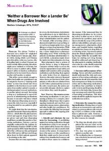
satellite to form the double-differenced observables. The DD residuals for various satellite pairs are as shown in Figure 1. They indicate the presence of systematic errors for most of the satellite pairs.
D. The wavelet-based method. Note that only L1 data was used here. The results obtained from all methods are discussed in the next section.
4. Analysis of Results Residuals(cycle)
0.1
0
PRN15-7 -0.1 20
40
60
80
100
120
140
160
Residuals(cycle)
0.1
0
PRN15-14 -0.1 20
40
60
80
100
120
140
160
Residuals(cycle)
0.1
0
PRN15-16 -0.1 20
40
60
80
100
120
140
160
Residuals(cycle)
0.1
0
PRN15-18 -0.1 20
40
60
80
100
120
140
160
0.1
Residuals(cycle)
Results obtained from the processing procedures described in section 2 have been analysed from two points of view: ambiguity resolution and the estimation of baseline components. For reliable ambiguity resolution, the difference between the best and second-best ambiguity combination is crucial for the ambiguity discrimination step. The F-ratio is commonly used as the ambiguity discrimination statistic and the larger the F-ratio value, the more reliable is the ambiguity resolution. The critical value of the Fratio is normally (arbitrarily) chosen to be 2.0 (e.g. Euler & Landau, 1992). The ambiguity validation test can also be based on an alternative statistic, the so-called W-ratio (Wang et al., 1998). In a similar fashion, the larger the W-ratio value, the more reliable the ambiguity resolution is assumed. The values of these statistics as obtained from the data processing step are shown in Table 1.
0
PRN15-29 -0.1 20
40
60
80
100
120
140
160
Epoch Number
Figure 1: DD residuals obtained for the Trimble data set of 18.12.1996. 3.2 Data processing step For convenience the data set was divided into four batches, each of ten minutes. Each batch was treated as an individual session and processed using the following four methodologies: A. The standard GPS processing method with the simplified stochastic model (which includes only mathematical correlation), and assuming that temporal correlations are absent. B. The semi-parametric method C. The iterative stochastic modelling method
Table 1: Comparison of the F-ratio and W-ratio statistics in ambiguity validation tests Method Session F-ratio W-ratio A I 3.84 13.52 II 21.37 34.03 III 18.64 34.30 IV 6.34 20.18 B I 10.86 69.54 II 66.93 124.71 III 42.83 117.04 IV 11.79 101.96 C I 2.07 6.61 II 6.89 16.85 III 7.58 17.78 IV 2.26 7.55 D I 9.92 85.47 II 64.14 156.42 III 41.35 131.53 IV 20.88 106.91 The F-ratio and W-ratio values obtained from the semi-parametric and the wavelet-based methods are larger compared to those obtained from the standard method. This is mainly due to the removal of nonlinear trends from the data. On the other hand, the iterative stochastic modelling method produces smaller F-ratio and W-ratio values.
In the case of the estimated baseline components, the results are compared with the reference values. The differences between the estimated values and the reference values are presented in Table 2. The results show that the iterative stochastic modelling and the wavelet-based methods produce more reliable estimated baseline components than the standard and the semiparametric methods. It can also be seen that the semi-parametric method produces results which are essentially identical to those obtained from the standard method. Table 2: The differences between estimated baseline components and the reference values Method Session Difference in each component dN (mm) dE(mm) dH(mm) A I -4.5 8.1 8.7 II 0.5 0.0 4.5 III 2.0 -5.4 -8.5 IV 2.7 -8.6 -18.9 B I -4.5 8.1 8.7 II 0.5 0.0 4.5 III 2.0 -5.4 -8.5 IV 2.7 -8.6 -18.9 C I 0.3 2.3 -4.5 II 0.5 -0.5 3.8 III 1.7 -5.0 -7.7 IV 5.2 -3.5 -9.9 D I -0.4 1.8 -2.0 II 3.0 -2.1 0.6 III 1.8 -2.6 -3.7 IV 1.3 -1.2 -5.3 In addition, the maximum difference in the height component between sessions is up to 27.6 mm when the standard and the semi-parametric methods are used. This is reduced to 13.7 mm when the iterative stochastic modelling method is applied, and to 5.9 mm in the case of the wavelet-based approach.
5. Concluding Remarks Recommendations
and
some
In this paper different GPS data processing algorithms used to account for systematic errors have been reviewed. A numerical example was used to compare the results obtained from these different algorithms. From this limited investigation, the following comments and recommendations can be made: • The semi-parametric method has shown significant improvement in ambiguity resolution. It is recommended that this method
should be used for applications where reliable ambiguity resolution is crucial. • The iterative stochastic modelling method has shown improvement in the accuracy of the estimated baseline results. However, this method gave a relatively poor performance for ambiguity resolution. The method is therefore suitable for high accuracy applications with long observation periods. • The wavelet-based approach seems to give the best performance, both in terms of ambiguity resolution and the achievable baseline accuracy. These methods are being investigated further in order to establish the degree of their effectiveness.
Acknowledgements The first author is supported in his Ph.D. studies by the scholarship from Chulalongkorn University, Thailand. The second author is the holder of an Australian Research Council (ARC) Postdoctoral Fellowship. Much gratitude to Mr. Minghai Jia for his suggestions on implementation of the semiparametric method. Special thanks also to Mr. Clement Ogaja and Mr. Michael Moore for helpful discussions with the authors.
References Euler, H.J. & H. Landau (1992) Fast GPS ambiguity resolution on-the-fly for real-time applications. 6th Int. Symp. on Satellite Positioning, Columbus, Ohio, 17-20 March, 650659. Jia, M., M. Tsakiri & M.P. Stewart (2000) Mitigating multipath errors using semiparametric models for high precision static positioning. Geodesy Beyond 2000 - The Challenges of the First Decade, IAG Symposia, 121, 393-398. Jia, M. (2000) Mitigation of systematic errors of GPS positioning using vector semiparametric models. 13th Int. Tech. Meeting of the Satellite Division of the U.S. Inst. of Navigation, Salt Lake City, Utah, 11-14 September, 1938-1947. Rao, C.R. (1971) Estimation of variance and covariance components- MINQUE, Journal of Multivariate Analysis, 1, 257-275. Satirapod, C. (2001) Improving the accuracy of static GPS positioning with a new stochastic modelling procedure. 14th Int. Tech. Meeting of the Satellite Division of the U.S. Inst. of
Navigation, Salt Lake City, Utah, 11-14 September. Satirapod, C., J. Wang & C. Rizos (2001a) A simplified MINQUE procedure for the estimation of variance-covariance components of GPS observables. Submitted to the Geomatics Journal of Hong Kong. Satirapod, C., C. Ogaja, J. Wang & C. Rizos (2001b) GPS analysis with the aid of wavelets. 5th Int. Symp. on Satellite Navigation Technology & Applications, Canberra, Australia, 24-27 July, paper 39, CD-ROM Proc. Wang, J., M.P. Stewart & M. Tsakiri (1998) A discrimination test procedure for ambiguity resolution on-the-fly. Journal of Geodesy, 72, 644-653. Wang, J., C. Satirapod & C. Rizos (2001) Stochastic assessment of GPS carrier phase measurements for precise static relative positioning. Accepted for publication in Journal of Geodesy.