Progress In Electromagnetics Research, PIER 102, 49–64, 2010
POSITIONING ACCURACY ENHANCEMENT USING ERROR MODELING VIA A POLYNOMIAL APPROXIMATION APPROACH S. A. Mitilineos and S. C. A. Thomopoulos National Center for Scientific Research “Demokritos” Institute of Informatics and Telecommunications Patriarchou Grigoriou Kai Neapoleos Str. Agia Paraskevi, Athens 15310, Greece Abstract—Location information is critical for the development of value-added location-based services, such as fraud protection, locationaware network access, person/asset tracking etc. Herein, a method for the enhancement of localization systems in terms of achieved accuracy is proposed, which can be applied to new as well as existing systems regardless the underlying localization technique. The method is based on modeling the position measurement error introduced by the localization algorithm using a polynomial approximation approach. Measurements results demonstrate the applicability of the proposed technique in enhancing accuracy in a low cost and efficient manner.
1. INTRODUCTION Localization of wireless units has received considerable attention during the past decade, while market forecasts raise high revenues on location-based services [1]. Location information is considered to add many potential applications to telecommunications systems, such as fraud protection, location-aware network access, person/asset tracking etc. At the same time, commercial as well as security localization accuracy requirements are becoming more rigorous, among others due to regulations enforced by governmental authorities [2, 3]. Several RF localization techniques have been proposed in the literature besides GPS, which may provide global coverage but requires specialized equipment and fails to operate indoors [4]. RF position Corresponding author: S. A. Mitilineos (
[email protected]).
50
Mitilineos and Thomopoulos
location techniques are classified to Direction-Finding (DF), RangeBased (RB) and Scene Analysis (SA) techniques [5, 6]. DF systems utilize antenna arrays and Angle-of-Arrival (AoA) estimation in order to localize a Mobile Station (MS). On the other hand, RB systems estimate the distance between the MS and a number of Base Stations (BSs), and then the MS’s position is calculated by the intersection point of the corresponding circles. Range estimation may be based on either the Time-of-Arrival (ToA) or the Received Signal Strength (RSS) of the incoming RF signal. Both DF and RB systems suffer from inherent propagation channel characteristics, such as large or small-scale fading [6]; therefore, inaccuracies on position location always appear regardless of the underlying localization algorithm. Nevertheless, there have been reported techniques for leveraging DoA and ToA measurements to improve accuracy in Non-Line-of-Sight (NLOS) environments [7–9], yet, both DoA and ToA measuringcapable equipment is expensive due to the need for antenna arrays and synchronization respectively. On the other hand, in the case where SA techniques are employed, the accuracy improvement with respect to traditional RSS-based techniques is significant, but with a high cost due to insitu measurements. In this paper, a new technique for improving the achieved accuracy of localization systems is proposed, by modelling the position measurement error using a polynomial approximation of its a posteriori pdf. The order and the coefficients of the approximating polynomials are optimized using a Genetic Algorithm (GA) as a method of choice. The proposed method is a batch processing method but with fixed complexity. It is a general method for improving localization accuracy irrespective of the underlying statistics of the observed process and the measurements. To that extent, the method can be applied to new or existing localization infrastructures regardless of the underlying localization method (DF, RB, SA or other). Furthermore, the accuracy improvement is made possible with only a fraction of insitu measurements compared to SA techniques. In the following, the proposed technique’s theoretical background is discussed in Section 2, while its efficiency is strongly supported by measurements results presented in Sections 3 and 4. 2. ACCURACY ENHANCEMENT METHODOLOGY 2.1. Theoretical Background As discussed in the introduction, most position estimation techniques rely on measurements of RSS, DoA or ToA or combinations of the three. The specific signal attributes are space and time-dependent, and
Progress In Electromagnetics Research, PIER 102, 2010
51
are referred to herein as location attributes. No matter what attributes the underlying localization technique is based on, in a practical mobile radio channel the signal experiences propagation attenuation, large scale fading (shadowing) and small scale fading [10]. Due to small scale fading, the signal attributes (strength, direction and time of arrival) will fluctuate in space and time [11]. Therefore, a location ~ n,i,j (di , tj ), i.e., the attribute which attribute may be denoted by Att is measured by the n-th Base Station (BS), when the MS is located at di := d~i (xi , yi ) at time tj (herein, i denotes a spatial and j denotes ~ n,i,j (di , tj ) is in general a a temporal index). More specifically, Att vector measurement from the n-th BS, whose elements can be either the received power Pn,i,j (di , tj ) from the MS, or the direction of arrival DoAn,i,j (di , tj ) from which the signal transmitted by the MS reaches the BS, or the time T oAn,i,j (di , tj ) in which the signal transmitted by the MS reaches the BS, or any combination of the three. In all cases, the underlying localization system will apply an operator on the measured attributes, in order to estimate the MS position. Let the position estimate be defined by ~ 1,i,j (di , tj ) Att Att ~ 2,i,j (di , tj ) , dˆi,j := F (1) ... ~ N,i,j (di , tj ) Att where F (.) is the position estimation operator, and N is the number of BSs participating in the position estimation procedure. We define the position estimation error by Di,j := dˆi,j − di . (2) Assuming that multiple measurements are available for any given spatial position, small-scale fading, and therefore time-dependence, may be smoothed out by averaging over an adequately large number of instantaneous measurements [12]. In that case, Equation (2) becomes T ´ 1 X³ˆ Di = di,j − di = dˆi − di , (3) T j=1
where dˆi =
1 T
T P j=1
³ ´ dˆi,j denotes the temporal average of the position
estimate. Assuming that an estimate of the error Di is available, the accuracy of the position estimate can improve by modeling the underlying localization error function using polynomials as described in the following subsection.
52
Mitilineos and Thomopoulos
2.2. Position Estimation Error Modeling The proposed technique is based on measuring the position estimation error of the underlying localization system at a relatively small number of points and using these points to determine the coefficients of the approximating polynomials. Let (xi , yi ), i = 1, . . . , K, designate the points from the coverage area selected to determine the coefficients of the approximating polynomials, where K is the total number of selected points. Let the localization error at a point (xi , yi ) along the x and y axes of the underlying coordinates system at time tj be denoted by Dx(xi , yi , tj ) and Dy(xi , yi , tj ) respectively. In the sequel, we use the reduced notations Dxi (tj ) and Dyi (tj ), where the explicit spatial dependence of the error functions Dx(xi , yi , tj ) and Dy(xi , yi , tj ) on (xi , yi ) is supressed for simplicity. In case multiple measurements are used to estimate a given location over a size T time window along Eq. (3), the average values of Dxi (tj ) and Dyi (tj ) over this time window are denoted by Dxi and Dyi respectively. Using Dxi and Dyi , i = 1, . . . , K, the error functions Dx(x, y) and Dy(x, y) (or better, a time averaged version of them) are approximated by the polynomials P (x, y) and Q(x, y) respectively, using a GA as a means of minimization of the approximating error. In other words, using only a small number of in-situ measurements at K points in space, estimates of the mean localization error functions are obtained for the entire coverage area using the GA to estimate the coefficients of the approximating polynomials by minimizing the difference norm between Dxi , Dyi and P (x, y), Q(x, y) respectively at the K sampling points. The new error estimates obtained through the use of the two approximating polynomials are used subsequently to calculate a more accurate localization estimate.
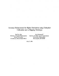
Figure 1. Functionality of the proposed technique.
Progress In Electromagnetics Research, PIER 102, 2010
53
The functionality of the proposed method is illustrated in Fig. 1, where the vertical axis corresponds to the error function polynomial estimation P (x) (a one-dimensional case is presented for clarity). The wireless unit is considered to lie at xi , while the location estimate of the underlying method at time tj is denoted by x ˆi,j . The respective localization error, Dxi,j , is calculated by Dxi,j = x ˆi,j − xi .
(4)
Using the location estimate x ˆi,j in the approximating polynomial P (x), an error estimate P (ˆ xi,j ) is obtained for x ˆi,j . This error estimate may then be used in order to obtain a new location estimate, as denoted by x ˆ+ i,j . We then have that x ˆ+ ˆi,j − P (ˆ xi,j ) . i,j = x
(5)
and the new localization error, Dx+ i,j , is given by Dx+ ˆ+ i,j = x i,j − xi .
(6)
Instead of |Dxi,j |, the achieved error is now |Dx+ i,j |. Thus, a new, more accurate estimate of the MS position is calculated. The application of the described method in 2D cases is straightforward. Measurements results presented in Section 4 demonstrate a significant accuracy enhancement in the case where the proposed technique is used. Furthermore, the implementation and computational complexity of the proposed technique is low and fixed, since it depends mainly on the number K of the selected points and the degree of the polynomial approximation functions. 2.3. Optimization of the Error Modeling Polynomial Functions Using a GA The approximation of the error functions is performed by a customdeveloped GA tool. GAs are a widely used stochastic optimization class due to their flexibility and suitability for multi-dimensional and multi-objective optimization problems [13]. GAs do not impose certain restrictions on the solution space, such as continuity or differentiation, while at the same time they converge to global optima more often compared to deterministc methods. Furthermore, GAs are considered to converge faster compared to other stochastic optimizationt techniques [13, 14]. The GA algorithm implemented herein is binary, while the selection, crossover and mutation functions used are roulette, simple and binary respectively. The objective functions of the utilized GA
54
Mitilineos and Thomopoulos
is calculated as follows: the functions Dx(x, y) and Dy(x, y) are approximated by Dx (x, y) ≈ P (x, y) =an xn + an−1 xn−1 + . . . + a1 x + bm y m + bm−1 y m−1 + . . . + b1 y + c1 Dy (x, y) ≈ Q(x, y) =dr xr + dr−1 xr−1 + . . . + d1 x + es y s
(7)
+ es−1 y s−1 + . . . + e1 y + c2 . For each (xi , yi ), two norms are calculated using ¯ ¯ N1 (xi , yi ) = ¯¯Dxi − P (xi , yi )¯¯ . N2 (xi , yi ) = ¯Dyi − Q (xi , yi )¯
(8)
Then, the norms are summed over all measurements points, using o Pn Σ1 = [N1 (xi , yi )]2 K n o . (9) P Σ2 = [N2 (xi , yi )]2 Kι
Finally, two GA objective functions are defined in order to separately optimize the coefficients of P (x, y) and Q (x, y), using f1 =
1 √ , 1 + Σ1
f2 =
1 √ , 1 + Σ2
(10)
respectively, where f1 , f2 ∈ [0, 1]. Using the objective functions of Eq. (10), the polynomial coefficients of P (x, y) and Q (x, y) are optimized independently by the GA such that the norm sums, Σ1 and Σ2 , respectively, are minimized. 3. MEASUREMENTS TESTBED SETUP In order to evaluate the performance of the proposed technique, a number of localization systems have been setup, based on various widespread techniques. More specifically, we have set up a SA (fingerprinting) system, a hybrid DoA-ToA system and an ultrasoundToA system. It should be noted that, during measurements and evaluation of the proposed technique, the area around the hereinafter discussed localization systems was used by personnel and visitors, thereby consisting a dynamic rather than a static environment. 3.1. SA-based Localization System Testbed A scene analysis (fingerprinting) localization system has been set up on the third floor of the Electrical and Computer Engineering School of the
Progress In Electromagnetics Research, PIER 102, 2010
55
Figure 2. Layout of the SA-based localization system deployed over the 3rd floor of the ECE-NTUA school. National Technical University of Athens, Greece, (ECE-NTUA) [15], building on the technique developed in [16]. More specifically, a Wireless Local Area Network (WLAN) was deployed at the specified area and a localization tool was implemented using MATLAB. The WLAN consists of six Access Points (APs) and a standard IBM laptop equipped with a PCMCIA WiFi card [16]. In Fig. 2, a layout of the measurements area is illustrated. Based on the methodology discussed in [17, 18], a grid of 70 points with a resolution of 3 m × 4 m is configured over the measurements area during the offline phase. Then, a set of Received Signal Strength (RSS) measurements from each AP was taken at each grid point, while separate measurements are taken with respect to the orientation of the user, as dictated by [17]. Finally, a two-dimensional matrix containing the average RSS values was built. During the on-line phase of the reference fingerprinting system, the user’s position is estimated by sampling the RSS received by the MS from each AP. The Euclidean distance in signal space between the on-line and off-line phase RSS vectors is calculated for each grid point.
56
Mitilineos and Thomopoulos
The three most eligible grid points are selected (those with minimum Euclidean distance) and the user’s position is estimated by a weighted average of these three points, as discussed in [16]. 3.2. Hybrid RF DoA-ToA Based Localization System Testbed. A hybrid DoA-ToA localization system has been set up within the premises of the Institute of Informatics and Telecommunications, National Center for Scientific Research “Demokritos”, Greece (IITNCSR) [19]. It is based on the commercial solution of Ubisense [20], and consists of four anchored reference sensors (Ubisensors), deployed on the ceiling of a typical office layout, configuring a cell which covers a typical office room, a meeting room and a corridor, as illustrated in Fig. 3. Furthermore, miniature mobile nodes (Ubitags) are attached to the objects that are to be localized. Each Ubitag periodically sends a beacon, which is captured by the four Ubisensors. Then, the Ubisensors calculate the DoA and ToA of each received beacon and transmit it to the Master Ubisensor. Finally, the Master Ubisensor uses a hybrid DoA-ToA localization algorithm in order to calculate the position of each Ubitag.
Figure 3. Layout of the hybrid RF DoA-ToA based localization system deployed over the IIT-NCSR.
3.3. Ultrasound-ToA Based Localization System Testbed Finally, an ultrasound-ToA localization system has been set up within the IIT-NCSR premises [21], based on the Cricket nodes developed by Bodhi [22]. A Cricket node is a mote able of operating in Beacon or Listener mode. While in Beacon mode, the Cricket node periodically
Progress In Electromagnetics Research, PIER 102, 2010
57
Figure 4. Layout of the ultrasound-ToA based localization system deployed over the IITNCSR. transmits an ultrasound pulse together with an RF pulse bearing identifying information. Nearby Listeners capture the RF pulse and launch a process which measures the time needed for the ultrasound pulse to arrive. If a sufficient number of Beacons is nearby, a Listener may be localized using triangulation techniques. In order to develop a Cricket-based localization system, we used six Beacons, which were attached on the ceiling of a typical office room, as illustrated in Fig. 4. A localization server is used in order to communicate with Listeners and launch the triangulation process. Since Cricket nodes are equipped with a serial RS232 interface, we used a Bluetooth-to-RS232 adapter in order to communicate with Listeners. Each time a Listener is to be localized, the localization server is connected to it and collects the respective ultrasound ToA measurements from nearby Beacons. Then, the range of the nearby Beacons is calculated and a triangulation procedure is launched in order to localize the Listener, as discussed in [21]. 4. MEASUREMENTS RESULTS 4.1. SA-based Localization System The performance of the SA-based localization system has been evaluated in terms of the Cumulative Distribution Function (CDF) of the achieved localization accuracy [15], and the results are presented herein in order to demonstrate the applicability of the proposed technique. A number of 50 MS positions (different than those used during the offline phase) are estimated and the corresponding accuracy
58
Mitilineos and Thomopoulos
Figure 5. Accuracy enhancement using the proposed technique with a SA-based localization system. Table 1. Accuracy enhancement using the proposed technique with a SA-based localization system. Using Using Improvement SA-based Proposed Technique [15] Technique [15] 99th-percentile 5.54 m 4.98 m 17.3% 90th-percentile 5.00 m 3.95 m 21.0% 67th-percentile 3.87 m 2.96 m 23.5% Mean Accuracy 3.27 m 2.06 m 37.0% CDF is illustrated in Fig. 5. The 99-th, 90-th and 67-th percentiles of the displayed CDF are 5.54 m, 5.00 m and 3.87 m respectively, while the respective mean accuracy is 3.27 m, as tabulated in Table 1. Then, the proposed technique is implemented by selecting a number of 10 points, in order to calculate the approximation of Dx(x, y) and Dy(x, y) via the polynomials P (x, y) and Q(x, y) respectively. It should be noted that the number of points used for polynomial approximation is only a small fraction of the number of points used during the offline phase (i.e., 70). The average error is calculated for each point and then the polynomial approximation functions are generated using the proposed GA. The “rank” of a bidimensional polynomial is herein defined by (a, b), where a is the rank of the x-dimension and is the rank of the y-dimension. The GA is
Progress In Electromagnetics Research, PIER 102, 2010
59
executed for various polynomial ranks (ai , bi ), ai = 0, 1, . . . , 5, bi = 0, 1, . . . , 5, and the optimal rank is selected. The ranks of the resulting polynomials are equal to (3, 0) and (2, 2) for P (x, y) and Q(x, y) respectively. More specifically, the polynomials P (x, y) and Q(x, y) are given by P (x, y) = 0.022 · x3 − 0.078 · x2 − 0.63 · x + 0.93 Q(x, y) = 0.03 · x2 + 0.23 · x + 0.021 · y 2 − 0.12 · y − 2.89
(11)
The proposed technique is evaluated with respect to achieved accuracy for another 50 points (other than those used during the fingerprinting online phase). The corresponding CDF of the accuracy error in the case where the proposed technique is used is also illustrated in Fig. 5. The 99-th, 90-th and 67-th percentile of the achieved accuracy are 4.98 m, 3.95 m and 2.96 m respectively, while the mean accuracy is 2.06 m, as tabulated in Table 1. It is noted that the accuracy enhancement when using the proposed technique varies from about 17% up to 37% for certain statistics. As deducted by Fig. 5 and Table 1, the percentiles as well as the mean accuracy are significantly improved in the case where the proposed method is used, relative to the localization accuracy provided by the SA-based algorithm alone. It is noted that the SA-based class of techniques is considered to provide more accurate localization results compared to plain RSSI techniques, but with a high cost of in-situ measurements. However, the proposed technique offers an even more accurate localization, with only a small fraction of required in-situ measurements. 4.2. Hybrid RF DoA-ToA Based Localization System In order to evaluate the performance of the proposed technique in the case where it is used with the hybrid DoA-ToA localization system, a Ubitag was attached on a tripod, at a height of 1 m, and position measurements were collected at 84 different points, which form a grid of dimensions 1 m × 1 m as illustrated in Fig. 3. The CDF of the achieved accuracy is displayed in Fig. 6. The 99-th, 90-th and 67-th percentiles of the displayed CDF are 1.08 m, 0.91 m and 0.48 m respectively, while the respective mean accuracy is 0.48 m, as tabulated in Table 2. Then, a number of 18 points are selected in order to implement the herein proposed technique. This time, the optimal polynomials given by the GA for the approximation of Dx (x, y) and Dy (x, y) are equal to P (x, y) = −0.08 · x − 0.20 · y + 0.27 , (12) Q(x, y) = 0.01 · x − 0.32 · y + 0.79
60
Mitilineos and Thomopoulos
respectively. The CDF of the localization error in the case where the proposed technique is combined with the hybrid DoA-ToA system is also illustrated in Fig. 6. The 99-th, 90-th and 67-th percentile of the achieved accuracy are 0.71 m, 0.52 m and 0.26 m respectively, while the mean accuracy is 0.27 m, as tabulated in Table 2. Again, it is deducted that the performance statistics of the localization system are significantly improved when using the proposed technique. Indeed, the accuracy statistics enhancement when using the proposed technique varies from about 34% up to 45% for certain statistics.
Figure 6. Accuracy enhancement using the proposed technique with a hybrid DoA-ToA localization system. Table 2. Accuracy enhancement using the proposed technique with a hybrid DoA-ToA localization system.
99th-percentile 90th-percentile 67th-percentile Mean Accuracy
Using Hybrid Using DoA-ToA Proposed Improvement System [19] Technique 1.08 m 0.71 m 34.2% 0.91 m 0.52 m 42.8% 0.48 m 0.26 m 45.8% 0.48 m 0.27 m 43.8%
Progress In Electromagnetics Research, PIER 102, 2010
61
4.3. Ultrasound-ToA Based Localization System Finally, the performance of the proposed technique when used with the ultrasound-ToA system is evaluated. Position measurements were collected at 30 different points, which form a grid of dimensions, as illustrated in Fig. 4. The CDF of the accuracy of the Cricket-based system is illustrated in Fig. 7. The 99-th, 90-th and 67-th percentiles of the displayed CDF are 1.20 m, 0.91 m and 0.33 m respectively, while the respective mean accuracy is 0.44 m, as tabulated in Table 3. Then, a number of 8 points are selected in order to implement the proposed technique. The optimal polynomials given by the GA for the approximation of Dx(x, y) and Dy(x, y) are now equal to P (x, y) = −0.07 · x + 0.03 · y + 0.27 , Q(x, y) = 0.02 · x − 0.28 · y + 0.69
(13)
respectively. The CDF of the accuracy in the case where the proposed method is used on top of the Cricket system is also illustrated in Fig. 7. The 99-th, 90-th and 67-th percentile of the achieved accuracy are 0.93 m, 0.51 m and 0.28 m respectively, while the mean accuracy is 0.30 m, as tabulated in Table 2. Once more, the statistics of the underlying localization system are significantly improved, since the accuracy statistics enhancement varies from 15.2% up to 43.9%.
Figure 7. Accuracy enhancement using the proposed technique with an ultrasound-ToA localization system.
62
Mitilineos and Thomopoulos
Table 3. Accuracy enhancement using the proposed technique with an ultrasound-ToA localization system.
99th-percentile 90th-percentile 67th-percentile Mean Accuracy
Using Cricket-based System [21] 1.20 m 0.91 m 0.33 m 0.44m
Using Proposed Improvement Technique 0.93 m 22.5% 0.51 m 43.9% 0.28 m 15.2% 0.30m 31.8%
5. CONCLUSION A new technique for accuracy improvement of localization systems is proposed herein, based on localization error modeling of the underlying positioning system using a polynomial approximation and a GA. The proposed technique is a post-processing method and may be used in order to improve the localization accuracy irrespective of the underlying statistics of the observed process and the measurements. Moreover, it imposes a low and fixed complexity computational cost compared to other batch processing methods. Measurements results denoted a significant accuracy improvement with respect to various well-established localization techniques, at the cost of only a small number of in-situ measurements. More specifically, the proposed technique was evaluated in a mixed indoor/outdoor as well as two indoor environments, using SA, hybrid DoA/ToA and plain ToA localization platforms. In all cases, the accuracy of the underlying systems was significantly improved, regardless the frequency of the RF equipment or the size of the covered area. ACKNOWLEDGMENT This work is supported in part by a Post-doctoral Fellowship of NCSR Demokritos and the Ministry of Development, Greece, and in part by the “EMERGE” (EMERGE-IST-FP6-2006-045056) and “HMFM” EU research projects. REFERENCES 1. Sayed, A. H., A. Tarighat, and N. Khajehnouri, “Network-based wireless location,” IEEE Signal Processing Magazine, Vol. 22,
Progress In Electromagnetics Research, PIER 102, 2010
2. 3.
4. 5.
6. 7. 8. 9.
10. 11. 12.
13.
63
No. 4, 24–40, July 2005. FCC Docket No. 94–102, “Revision of the commission’s rules to ensure compatibility with enhanced 911 emergency callin systems,” RM-8143, July 26, 1996. “Commission recommendation of 25 July 2003, on the processing of caller location information in electronic communication networks for the purpose of location-enhanced emergency call services,” Official Journal of the European Union, July 27, 2003. Hana, P. H., “Global positioning system overview,” ITRuniversity of Texas at Austin, available at: http://www.colorado.e du/geography/gcraft/notes/gps/gps f.html. Tayebi, A., J. G´omez, F. S. Saez de Adana, and O. Gutierrez, “The application of ray-tracing to mobile localization using the direction of arrival and received signal strength in multipath indoor environments,” Progress In Electromagnetic Research, PIER 91, 1–15, 2009. Liberti, J. and T. S. Rappaport, Smart Antennas for Wireless Communications: IS-95 and Third Generation CDMA Application, Prentice Hall PTR, April 1999. Seow, C. K. and S. Y. Tan, “Non-line-of-sight localization in multipath environments,” IEEE Transactions on Mobile Computing, Vol. 7, No. 5, 647–660, May 2008. Seow, C. K. and S. Y. Tan, “Localization of omni-directional mobile in multipath environments,” Progess In Electromagnetics Research, PIER 85, 323–348, 2008. Conan, J. L. J. and S. Pierre, “Mobile station location estimation for MIMO communication systems,” The 3rd International Symposium on Wireless Communication Systems, ISWCS 2006, 561–564, September 6–8, 2006. Stuber, G. L., Principles of Mobile Communication, Kluwer Academic Publishers, Norwell, MA, 1996. Paulraj, A., R. Nabar, and D. Gore, Introduction to Spacetime Wireless Communications, Cambridge University Press, Cambridge, UK, 2003. Liu, B. C., K. H. Lin, and J. C. Wu, “Analysis of hyperbolic and circular positioning algorithms using stationary signal-strength difference measurements in wireless communications,” IEEE Transactions on Vehicular Technology, Vol. 55, No. 2, 499–509, March 2006. Rostami, A. and A. Yazdanpanah-Goharrizi, “Hybridization of neural networks and genetic algorithms for identification of
64
14.
15.
16.
17.
18.
19.
20. 21.
22.
Mitilineos and Thomopoulos
complex Bragg gratings,” Journal of Electromagnetic Waves and Applications, Vol. 22, No. 5–6, 643–664, 2008. Kouveliotis, N. K., S. C. Panagiotou, P. K. Varlamos, T. D. Dimousios, and C. N. Capsalis, “Optimizing a PIFA using a genetic algorithm approach,” Journal of Electromagnetic Waves and Applications, Vol. 22, No. 2–3, 453–461, 2008. Mitilineos, S. A., G. K. Roumeliotis, C. N. Capsalis, and S. C. A. Thomopoulos, “Position accuracy enhancement using localization error modelling,” Proceedings of the 10th IEEE International Symposium on a World of Wireless Mobile and Multimedia Communications, 1–5, Kos, Greece, June 15–19, 2009. Mitilineos, S. A., S. C. A. Thomopoulos, D. K. Bougoulias, and C. N. Capsalis, “Position location using a minimum square error method: An indoor environment implementation,” Proceedings of the 4th International Conference on Telecommunications and Informatics, Vol. 1, 210–215, Prague, CZ, March 13–15, 2005. Bahl, P. and V. N. Padmanabhan, “RADAR: An in-building RFbased user location and tracking system,” Proccedings of the IEEE INFOCOM 2000: 19th Annual Joint Conference of the IEEE Computer and Communications Societies, Vol. 2, 775–784, 2000. Prasithsangaree, P., P. Krishnamurthy, and P. K. Chrysanthis, “On indoor position location with wireless LANS,” The 13th IEEE International Symposium on Personal, Indoor and Mobile Radio Communications, Vol. 2, 15–18, September 2000. Mitilineos, S. A., N. D. Argyreas, E. T. Makri, D. M. Kyriazanos, and S. C. A. Thomopoulos, “An indoor localization platform for ambient assisted living using UWB,” Proceedings of the 6th International Conference on Advances in Mobile Computing and Multimedia, Vol. 1, 178–182, Linz, Austria, November 24–26, 2008. Ubisense Solutions, http://www.ubisense.net/. Mitilineos, S. A., N. D. Argyreas, and S. C. A. Thomopoulos, “A near-optimal low complexity sensor fusion technique for accurate indoor localization based on ultrasound time-of-arrival measurements from low-quality sensors,” Proceedings of the XVIII Signal Processing, Sensor Fusion and Target Recognition Conference, SPIE Defense Security and Sensing 2009 Symposium, to appear, Orlando, FL, USA, April 13–17, 2009. Bodhi, N. P., “The cricket indoor location system,” Ph.D. Thesis, Massachusetts Institute of Technology, June 2005.