Prototype GIS application in Delta morphometry C.N. Chalkias, E.T. Karymbalis Department of Geography, Harokopio University, El. Venizelou 70, Athens, Greece. Telephone: +30 210 9549347 FAX: +30 210 9514759 Email:
[email protected]
Abstract The main purpose of this study is to demonstrate a method for the evaluation of deltaic region conditions extending Geographical Information System technology. The geomorphological characteristics of river deltas reflect dominant natural processes. The quantitative expression of these features, using morphometric indices, can upgrade delta configuration research. A prototype system was developed with main aim the extension of GIS analytical functions for delta morphometry computations. For this purpose the core of a GIS has been used and customized in order to produce useful indices through computations based mainly on the hypsography and the geometric characteristics of the river delta. The rapid and accurate computation of these indices is of fundamental significance for the integral study of any deltaic region.
1. Introduction Digital spatial datasets and satellite data are mainly conducted by Geographical Information System (GIS) and Remote Sensing (RS) experts while earth scientists, experts in field techniques, normally undertake the monitoring of deltaic regions. Therefore, despite the potential uses of various digital spatial data, such data are used rarely in delta monitoring studies, most times only for cartographic representations. The change of this status is strongly related with the development of tools incorporating a knowledge base. This base - developed to automate computational tasks – supports the process of information extraction about this significant, fragile and dynamic physical environment. River deltas are the most sensitive and complex ecosystems at the land - water interface due to many physical factors leading to their formation and evolution. They are of fundamental socioeconomic significance attracting agricultural, rural, fishing as well as tourism activities. The lack of extended plains suitable for cultivation in mountainous countries like Greece enhances the important role of the low-lying deltaic areas for economic development (Karymbalis et al, 2001). Furthermore, deltaic environments comprise significant wetlands. Nevertheless, deltas like other low-lying coastal areas are extremely sensitive in near future anticipated rapid sea level rise due to the melting of continental glaciers and the expansion of the oceanic water masses, the so-called steric effect, triggered by a rise in air temperature (IPCC, 2001).
It is estimated that 37.96 km2 of the low-lying deltaic areas in Greece are to be inundated by the sea until the year 2100 (Gaki Papanastassiou et al., 1997). Delta morphometric analysis is a quantitative way to relate fluvial and marine processes to the morphology of the delta (Stournaras 1990, 1999). As noticed by Longley (1998) geocomputation has become integral to our understanding of spatial structures. The applied method attempted in the present paper constitutes an upgrade of the methodology proposed in the early 1970's by Wright and Coleman (1973). This method can be adapted to any delta taking into consideration individual characteristics and geomorphological irregularities. In addition, the present application is a contribution in proposing delta classification. This classification reflects process regimes ranging from fluvial-dominated to wave dominated deltas. Quantitative estimations using geocomputation techniques in association with qualitative geomorphological field observations, especially in the vicinity of the land water interaction coastal zone, can significantly help the interpretation of the recent geomorphological evolution of the delta. Similarly, the configuration of the deltaic coastline can be investigated quantitatively, defining retreating and prograding regions. Evinos river delta, located at the central and western part of Greece, was chosen as a test area, because of its representative construction as a Greek delta and the availability of a large amount of data from previous studies (Karymbalis, 1996). The discussion is organized as follows. After this introduction, section 2 presents the datasets used in this study and the general organisation of the system. Section 3 presents the conceptual framework of the whole methodology. In section 4 we give details about the morphometric calculations, and finally section 5 concludes with the discussion of the study, the final results and the future expansion of the research.
2. System - Data Structure Nowadays the main GIS software vendors have created integrated software packages to meet the need of a diverse user community (Longley et al 2001). The dominant trend is to develop systems for “general use”. Modern GIS software packages have limited intelligence in handling and modeling specific geographical phenomena, although they have rich toolboxes and remarkable analytical potential. Thereby, these systems do not provide specific operations for computing explicitly special parameters related to delta features. However, GIS offers several functions and analytical procedures, which might be useful in an effort to develop a prototype system for computing delta characteristics and supporting delta classification. Specifically a GIS provides – among other capabilities - functions for terrain modeling and analysis (Digital Elevation Model creation from various sources, slope calculation, generation of topographic sections, etc.) as well as for geometric and spatial statistical calculations (Chalkias and Stefanakis 2002). Thereby, a prototype Integrated GIS for river delta analysis has been created. The main concept is the expansion of GIS functionality in order to support delta morphometry computations and involve bi-directional connections between GIS and spatial analysis (Fotheringham 2000). The first phase of this work – after the conceptual design – was dedicated to the data acquisition and integration as well as to the construction of the spatial datasets of the system. These datasets distinguished in two main categories. The first one comprises data concerning
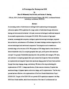
the overall related geographical features of the study area (topography, land use, geology, road network) while the second one includes information about delta as a physical system (river channels, current deltaic protrusion, delta axes). Collections of spatial entities were organized in a number of thematic layers. The data model adopted in this study treats both single and related collections of spatial entities and can be used to define spatial operations independently on the fundamental raster and vector models. Datasets and metadata for each river delta are organized and stored in specific data folders of the system. The key point of the data structure concept is the potential use of both raster and vector data models providing at the same time conversion functions from the former to the latter and vice versa. One of the most significant datasets used in this work is the Digital Elevation Model (DEM) of the area. The DEM of the test area (figure 1) was created using appropriate vector data (contour lines, elevation spots, river channels) and specialized procedures (ANUDEM algorithm, Hutchinson, 1989) in the framework of the GIS used. Alternatively the DEM can be created by proper satellite data. This latter approach will ensure fast acquisition of updated elevation data for every place on earth. A number of secondary geographical variables, which are very significant in morphometric analysis, were derived from the DEM. These variables are related to elevation measurements, slope, volumetric computations, and curvature.
Figure 1. Digital Elevation Model of the test area. It must be noted that the digital modeling of hypsography was implemented not only with DEM but also with contour lines. Thereby, alternative computational methods - elevation data - were supported. The conceptual framework of the developed system is described in the next section.
3. Conceptual framework of the System - Methodology As mentioned above the developed method extends utilities offered by a standard commercial GIS. As an outcome, a prototype system has been developed. The core system consists of a commercial GIS software package (ArcGIS) supporting both
vector and raster spatial data sets. This software is extended with special external functions (developed in a third generation programming language) implemented for the morphometric analysis. The architecture of the prototype is illustrated in Figure 2. The general concept is as follows. The core is a standard GIS. This system was enriched with functions developed especially for the geomorphometric analysis of the river delta. These functions are operating in relevant spatial datasets incorporated in the system and originated from analogue maps, previous digital datasets, satellite imagery or fieldwork. River morphometry is estimated through special computational procedures using mainly the DEM of the deltaic protrusion and the delta geometry. The DEM - which is the main digital model used for the computations - is created by using the internal GIS functionality of the prototype. Features corresponding to delta geometry cannot only manually be input but can also be calculated through semiautomated procedures of the system. The final outputs could be arithmetic features corresponding to specific morphometric indices - ratios, reports presenting morphometry of a river delta, or advanced visualization.
Subaerial and Sub aqeous topography
Analogue maps
Digital Data
River channels
RS Data
Field work
DEM Data derived from DEM Slope, curvature Vegetation, land use, etc
Semi - automatic calculation
Active channel
User interaction Calculation methods Output definition
Elevation Bathymetric isolines
G.I.S
Output Morphometric indices Reports
Special developed functions
Visualization (cross sections diagrams)
Delta geometric features
Figure 2. Architecture of the prototype system. Notice the extensibility of the system. Many special applications can be developed to support various computational processes using different layers (vegetation, land use, geology etc). Another characteristic of the system is that different data sources can be supported. Although digitized data were used for the tests, it is rather significant to ensure the potential use of remotely sensed data (e.g. precise elevation data from radar altimetry, or river channels from multispectral images) as the latter can provide detailed and up to date geographical information frequently via automated procedures. The end user interacts with the system in many ways, by defining river delta geometric features or providing inputs for their automatic determination and by determining the calculation methods (DEM or contour line based approach) and some of the variables that are
necessary for the computations (e.g. number of slices for contour length computation). Finally, different types of the output can be defined (indices as numbers, reports, cross sections, diagrams, maps). The system created provides an advanced method to organize, analyze, compute and visualize spatial information and morphometric features for a river delta. It also provides appropriate tools and procedures for delta comparisons and classification as well as for the dynamic evaluation of a river delta using time series of spatial data. These indices are described in detail in the following section.
4. Geomorphometric computations River Delta configuration can be described quantitatively through morphometric parameters (indices and ratios). River deltas around the world present a protrusion formed by fluvial sediment deposition. Delta morphometry focuses on deltaic protrusion area. The subaerial part of the protrusion is defined by the delta coastline and the width axis which is the maximum width of the deltaic plain (CD in figure 3 represents width axis of the Evinos delta). The subaqeous part of the protrusion is the submarine continuity of the deltaic plain and extends seaward down to the depth that a steep slope is developed. Figure 3 illustrates the deltaic protrusion of the Evinos river located in Western Greece. In order to express numerically the seaward extension of the deltaic protrusion various morphometric parameters have been developed such as Rp and Rc presented and explained in table 1.
Figure 3. Measured terms of delta morphometric analysis. CD: maximum delta width axis, AB: delta length, n = 16, ri: right segments, li: left segments. Evinos delta, western Greece. In order to relate the morphology of the delta to the fluvial and marine processes interaction, the numerical expression of the clastic sediments distribution for each side (left and right) of the central length axis of the protrusion is necessary (AB in figure 3 corresponds to the length
of the deltaic protrusion for the Evinos river). For this purpose the deltaic protrusion has been divided in a number of segments (n) of equal lateral width (x) as shown in figure 3 and sediment volume for each segment has been estimated. Cumulative sediment volume for each side of the deltaic protrusion is another useful parameter in delta configuration interpretation. The volume distribution as well as the dominance of fluvio-torrential or marine processes can also be numerically expressed by parameters such as protrusion distribution indices (ßl, ßr, ß). Obviously, the profile and shape of the subaqeous part of the protrusion demonstrates the discharge - wave power interaction. The general slope and curvature of the subaqeous delta is indexed by the subaqeous hypsometric interval (HI), which constitutes an important parameter in delta morphometry. River delta morphometric parameters used in quantitative geomorphological analysis can be grouped in two main categories: direct measures and calculations (indices, ratios). Direct measured parameters included in Table 1, derived from digital cartographic representations. These parameters can be inserted by the end-user manually. This approach can be adapted to meet the special needs of each case study. For example, increasing the number of segments (n), more detailed data are extracted. Some of these parameters are automatically defined. For example, basal threshold line, which is the limit of clastic river borne delta sediments and is expressed by an abrupt breaking in subaqeous slope, can be precisely selected by the DEM. Table 1. Direct measured delta morphometric parameters. Symbol
Explanation - Remarks
unit
W
Maximum width of the delta protrusion.
Km
L
Length of the deltaic protrusion measured perpendicular to the width.
Km
Ls
Shoreline length. This parameter is scale depended.
Km
n
Number of segments of equal lateral width. The user can insert alternative number of segments.
x
Width of each segment. The user can insert alternative x width.
Km
as
Area between any given depth contour around the deltaic protrusion and the shoreline.
Km3
As
Area between the basal threshold line and the shoreline. Threshold line definition can be computed using DEM.
Km3
z
Vertical distance above the basal threshold line. Input of reference elevation.
M
Z
Total vertical distance from the basal threshold line to the shoreline.
M
A0-h
Area between shoreline (0 m) and the h meters of elevation. User can insert various elevations (usually 0.5 m, 1 m and 4 m) depending on the scale of the delta under investigation. Area calculation is resulted using DEM.
Km3
-
Calculated parameters showing in table 2 constitute the main output data. Most calculated parameters are automatically computed using DEM. Qualitative interpretation of these parameters defines dominant geomorphological processes affecting delta evolution. Table 2. Calculated delta morphometic parameters. Symbol
Explanation – Remarks
Rp
Ratio revealing the seaward extension of the deltaic protrusion
Rp =
L W
-
Rc
Crenulation ratio of the delta shoreline expressing the delta coastline irregularity. This ratio is scale depended.
Rc =
Ls W
-
vj
Sediment volume of each segment, extracted from DEM.
Formula
h
v j = ∫ adz
unit
Km3
bc
Vj
Cumulative volume of deltaic clastic sediments from the axis to the jth interval. This parameter is extracted from DEM.
Km3
j
∑v j =1
j
Cumulative dimensionless volume. Vn corresponds to the total volume.
V j' =
Vj
Sk
Skewness ratio. Expresses the degree of the skewness of the deltaic protrusion, automatically calculated using DEM.
Sk =
Vr Vl
-
ßl
Protrusion distribution index for the left half of the deltaic protrusion corresponding to the dimensionless long shore distance xj’ at which Vj’ cumulative dimensionless sediment volume attains a value of 0.5. This index is calculated automatically.
xjl’ if
-
Vj?
ßr
ß HI
Rv
Protrusion distribution index for the right half of the deltaic protrusion corresponding to the dimensionless long shore distance xj’ at which Vj’ cumulative dimensionless sediment volume attains a value of 0.5. This index is calculated automatically. Mean protrusion distribution index. Expresses numerically the sediment volume distribution.
-
Vn
Vjl = Vjl’/2
xjr’ if
-
Vjr = Vjr’/2
β =
(β l + β r ) 2
-
0 Subaqeous hypsometric interval revealing the general slope as z d HI = ∫ and curvature of the subaqeous delta profile. Z A bc s
-
Vulnerability ratio expressing the area that will face significant problems due to the anticipated sea level rise. Elevation h expresses the anticipated sea level rise and is inserted by the user. Ad represents the area of the deltaic prominence defined as the area between the shoreline and the delta Width axis.
-
Rv =
A0−h Ad
The overall data flow in the system is as following. The user interacts with the system by defining the folder containing thematic layers of the river delta. After the visualization of these layers the maximum width length is pointed. It must be noticed that the evaluation of the layers corresponding to the topography, geology, and geomorphology of the broader area supports this identification. The next step is the definition of the delta length. This might be done either manually or by identifying abrupt slope changes in the subaqeous area. Finally, the computational method and the type of outputs are defined. The processing of large amount elevation data is conducted via special developed geocomputational processes. The computation of basic indices and ratios is rather simple. On the contrary, the calculation of complex indices requires advanced geocomputational techniques for surface analysis (area, volume and curvature) calculations. For example, the calculation of protrusion distribution indices (ßl and ßr) for each side of the delta requires iterative volume computations, until the cumulative volume is the half of the total. The comparative advantage of the methods that use DEM and a large number of segments is the potential identification of slight local topography changes which indicate topic conditions.
5. Discussion As an outcome of this study a prototype system has been developed. This approach provides researchers examining physical processes with a method for advanced computation of information on river delta conditions. It can also be considered as a paradigm of modeling natural phenomena using Geocomputation techniques and extending GIS functionality. Referring strictly to the application domain, it can be mentioned that the use of DEM upgrades the whole analytical approach and accommodates quantitative morphometric estimations, providing therefore, more accurate estimations compared with conventional methods. Although data from analogue maps have been used – at this first phase of the research – representing a rather ‘static’ situation, the future use of real time satellite data will enhance the accuracy of the results and permit monitoring of changes. One of the most significant extensions of this study is the application of the methodologies described above in major river deltas of Eastern Mediterranean. The future work also includes the development of computational tools for spatio-temporal analysis of river deltas, and the incorporation of other geographical factors (oceanographic and climate element) and indices reflecting the dynamic relationship between delta as a changing physical system and human activities and presence. The basic future intent is to build an integrated system for advanced geo-modeling of river deltas.
6. References CHALKIAS, C. and STEFANAKIS, E., 2002, Modeling Insolation in the application domain of GIS. 6th Pan-Hellenic Geographical Conference, Vol II, 281 – 287. GAKI-PAPANASTASSIOU, K., MAROUKIAN, H., PAVLOPOULOS, K. AND ZAMANI, A., 1997: The implications of the expected sea level rise on the low-lying areas of continental Greece in the next century, in Proc. International Symposium On Engineering Geology and the Environment, Athens: 121-126. HUTCHINSON, M.F., 1989, A new procedure for gridding elevation and stream line data with automatic removal of spurious pits, Journal of Hydrology: 106 : 211 – 232.
FOTHERINGHAM, S.A., 2000, Geocomputation analysis and modern spatial data, in Geocomputation ed. by Opanshaw S. and Abrahart J., Taylor and Francis, London, 33-47 . IPCC, 2001, Climate Change, Synthesis Report. - Watson, R.T. and the Core Writing Team (eds.), Geneva, 184 pp (Stand-alone edition). KARYMBALIS, E., 1996: Geomorphological observations in the drainage basin of Evinos river. Unpublished Ph.D. Thesis, University of Athens, 244 pp. (in Greek). KARYMBALIS, E.. TEGOU, M., and TSALKITZI, O., 2001, Study of delta formation factors at Central Greece. Bulletin of the Geological Society of Greece 34(1): 381388. LONGLEY, P.A., 1998, Developments in Geocomputation, Computers, Environment and Urban Systems, 22, pp.81-83. LONGLEY, P.A., GOODCHILD, M., MAGUIRE, D.J., and RHIND, D., 2001, Geographic Information Systems and Science, John Wiley & Sons, Chichester, 454pp. STOURNARAS G., 1990. Etude géet morphométric du delta du Mornos (Grèce centrale). Possibilités de prévision du régime hydrogéologique. Besançon: Ann Sci Univ France-Compté 4:59-67. STOURNARAS, G. 1999 Assessment of morphometric parameters of Greek Rhone-type deltas. Hydrogeologic and environmental aspects. Environmental Geology 38 (1): 5358. WRIGHT, L. D. and COLEMAN, J. M., 1973, Variations in morphology of major river deltas as functions of ocean wave and river discharge regimes, The American Association of Petroleum Geologists Bulletin 57 (2), 370-398.