Landsat TM/ETM+ (Thematic Mapper, and Enhanced Thematic Mapper) ... Forest Change (GFC) annual tree cover loss dataset is based on Landsat 7 ETM+.
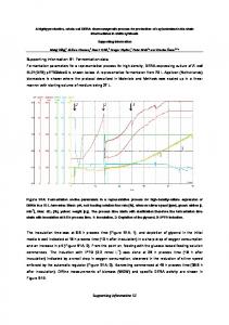
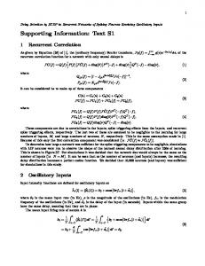
S1 Appendix. Supporting information to “Can global datasets be used to support fine-scale assessments of deforestation causes in Latin America?” Additional information on datasets and methods GlobeLand30 The GlobeLand30-2010 dataset is a global, multi-class land cover dataset provided at 30-m resolution by the National Geomatics Center of China (NGCC) [1]. It is based primarily on Landsat TM/ETM+ (Thematic Mapper, and Enhanced Thematic Mapper) supplemented by HJ1 data, that are classified into 10 land cover classes using a combination of pixel- and objectbased classification, along with manual verification [1]. We use the 2010 version of GlobeLand30, for which the input data varies from 2006 to 2012 in Latin America (Fig A). There is also a GlobeLand30 product for the year 2000, which was not used in this study.
Fig A. Map showing the year of the Landsat data used for the GlobeLand30-2010 classification. Data set provided by the National Geomatics Center of China (DOI10.11769/GlobeLand30.2010.db) [1, 2].
1
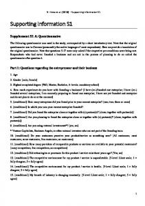
Table A. Previous accuracy assessments of GlobeLand30.
Study Overall accuracy Chen et al. [1] 80%
Coverage Global
Brovelli et al. [3]
Italy
Jokar Arsanjani et al. [4] Jokar Arsanjani et al. [5]
81 – 92% (5 CORINE classes; ~3–4 % better outside buffer.) 74% (OSM) –92% (CORINE) agreement. Urban Atlas and ATKIS (best reference sources) > 85%. 78%
Class specific results User’s accuracies for Cultivated land (83%), Grassland (72%), Forest (84%). (Table 9 in [1].)
Germany
CORINE, Urban Wetland poor Atlas, OpenStreetMap and ATKIS
Iran
GoogleEarth Confusion matrix sample points, available OpenStreetMap, Flickr Based on validation dataset from Zhao et al. [7], and 7 high resolution images. GoogleEarth sample units
Lambert et al. 88% [6]
Sahelian and Sudanian agrosystems
Yang et al. [8]
China
83%
Reference data Based on 150 000+ test samples (GoogleEarth, TM images, etc.) CORINE, Italian regional datasets (DUSAF)
GFC The Global Forest Change (GFC) annual tree cover loss dataset is based on Landsat 7 ETM+ growing season data [9]. The commission error for GFC loss to 13% and 21% in the tropics and sub-tropics respectively, and omission errors of 17–21% in the tropics/subtropics [9]. In a more recent accuracy assessment (using multi-temporal Landsat and GoogleEarth imagery for 1200 30x30 m reference pixels) Tyukavina et al. [10] found even lower commission and omission errors for Latin America.
PRODES Deforestation in the Brazilian Legal Amazon (BLA) has been monitored within the PRODES program by the Brazilian National Institute for Space Research (INPE) since 1988 [11]. We used this dataset on annual deforestation for 2001 to 2014. PRODES is primarily based on Landsat data July–September [12]. The PRODES data includes attributes on the year that deforestation was detected, as well as on when the area was last observed (e.g. if the area was covered by clouds in the preceding years). For example, d2001_4 is used for deforestation detected in 2001, in an area which had not been observed for four years prior. In our analysis we ascribe the deforestation to the earliest year of these (e.g. for d2001_4, we treat this as deforestation in 1997), to ensure that only pixels deforested within the analysis time period were included in the main analysis.
2
TerraClass TerraClass is based primarily on the same Landsat imagery as PRODES, focused on the time period July–September [12].
TerraClass and GlobeLand aggregated classes look-up table For some of the analyses, we use aggregated classes for GlobeLand30 and TerraClass. Tables A and B detail how the original classes were aggregated. Table B. Look-up table of aggregated GlobeLand30 classes used in this study. Aggregated GlobeLand30 classes
Grassland Cultivated land Forest Shrubland Other
Original GlobeLand30 classes
Grassland Cultivated land Forest Shrubland Artificial surfaces, Bareland, Snow and ice, Water bodies, Wetland, (Shrubland – for comparison to TerraClass only)
Table C. Look-up table of aggregated TerraClass-2010 classes used in this study. Aggregated TerraClass classes
Pasture Annual crops Forest Other Non-forest/ Secondary veg.
Original TerraClass classes
PASTO_LIMPO, PASTO_COM_SOLO_EXPOSTO, PASTO_SUJO, REGENERACAO_COM_PASTO AGRICULTURA_ANUAL FLORESTA OUTROS, AREA_NAO_OBSERVADA, AREA_URBANA, DESFLORESTAMENTO_2010, HIDROGRAFIA, MINERACAO, MOSAICO_DE_OCUPACOES, REFLORESTAMENTO NAO_FLORESTA, VEGETACAO_SECUNDARIA
Administrative and biome boundaries Country boundaries were retrieved from the GADM database of Global Administrative Areas via DIVA-GIS at http://www.diva-gis.org/Data/ (on 2015-08-21). Biome boundaries for Brazil were obtained from the Brazilian Ministry of Environment (http://mapas.mma.gov.br/i3geo/datadownload.htm).
Data access and processing Data processing and analysis was primarily carried out using Safe Software’s FME Desktop (2015.1.1 Build 15515). Some reprojections were done in QGIS 2.16.0, as was the creation of an (equal size/area, approx. 3 200 km2) hexagonal grid (using the mmqis plugin). Most figures were created in R with ggplot, and Excel, except the maps, which were created in Environmental Systems Research Institute’s (Esri) ArcMap 10.2. As we here use data that were are available online, data were downloaded from their respective online locations and reprojected as needed.
3
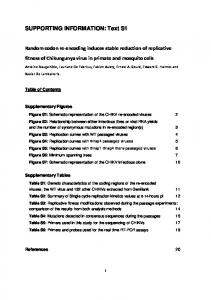
The Global Forest Change data version 1.2 were downloaded (on 18 December 2015) via http://earthenginepartners.appspot.com/science-2013-global-forest. The part of the dataset used here was the “year of gross forest cover loss event (lossyear)”, provided in tiff format. The forest loss data were masked to where canopy cover in the year 2000 exceeded 30% (based on GFC treecover2000, downloaded on 20170112 using the R package gfcanalysis, 2015 version (v.1.2) of data). The GlobeLand30-2010 data set is provided by National Geomatics Center of China (DOI10.11769/GlobeLand30.2010.db) and was ordered via http://www.globallandcover.com and subsequently downloaded (between November 2015 and March 2016). In addition to the geotiff files containing the land cover classification, the data were supplemented by a shapefile with information on the source Landsat tile used, which we use to gain information on the actual year the land cover classification was valid for. The PRODES data were accessed via http://www.dpi.inpe.br/prodesdigital/prodes.php (in February 2016). The version used here was the 2014 version of the state mosaics in shape (vector) format. Only polygons marked (in “mainclass”) as “desflorestamento” or “residuo” were used. The full set of TerraClass data for 2010 were downloaded from http://www.inpe.br/cra/projetos_pesquisas/terraclass2010.php (except tiles 231/61 and 231/68, which were not available at the time of download on 2016-01-16). In a visual examination of the datasets, PRODES and TerraClass align well with each other, as do GFC and GlobeLand30 (Fig B), but PRODES / TerraClass seemed somewhat offset relative to GFC / GlobeLand30. Therefore, PRODES and TerraClass data were offset by -0.001 degrees in longitude and 0.001 degrees in latitude. This improved the correspondence between PRODES and GFC, seen in the number of pixels classified as deforested by both datasets.
Fig B. Example of alignment between GlobeLand30 and GFC (in Mato Grosso, Brazil). Shown in simple overlay. Left: GlobeLand30 (based on 2006-data). Right: Same area with GFC forest loss 2001– 2005 overlaid (in grey/black) on GlobeLand30 (Forest is shown in dark green, Grassland in bright green). GlobeLand30 dataset provided by the NGCC (DOI10.11769/GlobeLand30.2010.db) [1, 2], GFC forest loss data source: Hansen/UMD/Google/USGS/NASA.
To combine the datasets pixel-by-pixel, all datasets were aligned to the GlobeLand30 grid. To reduce the consequences of shifting when aligning raster pixels for the pixel-by-pixel comparisons, the GlobeLand30 data were rescaled to a third of their input pixel size (i.e. from c. 30 m to c. 10 m; this does of course not improve the actual resolution of data). PRODES and TerraClass were then rasterized to directly match this grid, and the GFC data slightly resampled (all resampling done using nearest neighbour) and/or offset, and the analysis performed at this
4
finer resolution. Pixel cell sizes were calculated in a Lambert Azimuthal Equal Area projection for each tile. The map comparing overlap and differences between PRODES and GFC (S1 Fig) was created by reclassifying the pixels into three classes: PRODES only; GFC only; and “Both” for pixels labelled as deforested by both datasets at some point during the years 2001–2012. For this map, the comparison was made for the full time period, and any differences in timing between forest loss in the two datasets were not taken into account. For visualisation only, data were resampled to approx. 60-m resolution.
Shares of GFC forest loss that could be attributed a post-loss GlobeLand30 land cover The amount and share of GFC forest loss that could be attributed a post-loss GlobeLand30 land cover per forest loss year are shown in Fig C and S2 Table. Amounts and shares are per country are shown in S3 Table, and per hexagon in Fig D.
Fig C. GFC forest loss that could be attributed to a post-loss GlobeLand30 land cover class per year (as the GlobeLand30 land cover data post-dated the forest loss).
5
Fig D. Map of GFC forest loss percentage that could be attributed to a post-loss GlobeLand30 land cover class (as the GlobeLand30 land cover data post-dated the forest loss), per hexagon.
6
PRODES – GFC inter-comparison Many pixels are marked as deforested by only one of GFC and PRODES, but for the pixels classified as forest loss by both datasets, the timing is in many cases within a few years of each other (Fig E and S4 Table). As Richards et al. [13] note, this can in part be due to the different time of year that the datasets are based on. A quarter of the additional GFC forest loss was found by Richards et al. [13] to be in areas smaller than PRODES minimum mapping unit (6.25 ha). Similar comparisons between PRODES and GFC have been done by Fanin et al. [14] and Richards et al. [13]. Fanin et al. [14] perform their analysis at a coarser resolution (500 m). The analysis by Richards et al. [13] differ slightly from what is done here in that they use a 90-m raster version of PRODES (whereas we use the vector version) and also do not include deforestation for 2001.
Fig E. Visualisation of the cross-tabulation between the forest loss years in GFC and PRODES. Table D. Land cover 1–2 years prior to forest loss (NB: only for where land cover data for the relevant time period was available, so the area expressed in Mha does not cover all of the deforestation).
GlobeLand GFC Forest 58% (1.8 Mha) Grassland 25% (0.8 Mha) Cultivated 3% (0.1 Mha) land Other 14% (0.4 Mha)
PRODES 71% (1.1 Mha) 19% (0.3 Mha)