It was found that Darjiling, Hooghly, Howrah, North 24 Parganas are most developed districts; Jalpaiguri, Dakshin Dinajpur,. Murshidabad, Burdwan, Birbhum ...
International Journal of Academic Research and Development
International Journal of Academic Research and Development ISSN: 2455-4197, Impact Factor: RJIF 5.22 www.academicsjournal.com Volume 2; Issue 3; May 2017; Page No. 138-143
Spatial variation in demographic development in West Bengal: A district level analysis *1 1
Mithun Ray, 2 Mijanur Rahaman
Junior Research Fellow, Department of Geography, North-Eastern Hill University, Shillong, Meghalaya, India 2 Guest Faculty, Department of Geography, Dewanhat Mahavidyalaya, Cooch Behar, West Bengal, India
Abstract Development is a multi faced process by which a nation improves the economic, political, and social well-being of its people and it has spatio-temporal dimension. Inter-regional disparity has been an integral feature of the history of India’s socio-economic development. The present paper analysed district level disparity in West Bengal, India in terms of demographic development using fourteen indicators related to level of urbanisation, literacy, sex ratio and diversification of rural economy. Data of Census of India (2011) was analysed using Z score and Composite Standard Score to determine the relative level of disparity among the districts. It was found that Darjiling, Hooghly, Howrah, North 24 Parganas are most developed districts; Jalpaiguri, Dakshin Dinajpur, Murshidabad, Burdwan, Birbhum, Purba and Paschim Medinipur, Nadia and South 24 Parganas are moderately developed; and Puruliya, Bankura, Cooch Behar, Maldah, Uttar Dinajpur are least developed. Decentralised distribution of infrastructural investment can minimize regional imbalances. Keywords: demography, regional disparity, composite standard score, decentralisation 1. Introduction Population is the key resource for the overall development of any nation. Man is one of the three resource creating factors. Man plays the dual role of a producer or creator and a consumer or destroyer of resources. Man offers his labour primarily mental and secondarily physical when he creates a resource. On the other hand, they are sole beneficiary of the entire process of development and advancement of civilization [1-3]. Therefore, all development should address the people. But when fruits of development are not equally distributed that creates hindrances towards even and equal progress of a nation [4]. Inter-regional disparity has been an integral feature of the history of India’s socioeconomic development. The magnitude of regional disparity became wide during the British colonial period. Disparity in demographic development has not only found in state level but also in block and district level. After independence in 1947, a considerable emphasis was given to eliminate regional disparity [5, 6]. Again, since the economic liberalization in the early 1990s, the evidence suggests increasing inequality (in both spatial and vertical terms) as well as persistent poverty [7, 8]. An unchanged and uncontrolled process of growth leading to regional economic disparities results in numerous economic, social and cultural problems, and also lead to underutilization or even to non-utilization of economic resources, both natural and human and in that process individual are discriminated [9,10] . Despite multiple efforts being undertaken, India has still been experiencing a wide inter as well as intra-regional disparities, both at macro and micro level in socio-economic and infrastructural development. A number of study had been carried out in India to identify regional disparities and inequalities in terms of agricultural development [11, 12], social development [13, 14] , economic development [15, 16],
demographic development [17, 18]. Study related to regional disparity helps planners to take proper initiative to minimize regional inequality. In this paper an attempt is made to analyse the levels of demographic development in the state of West Bengal. The levels of demographic development has been measured in terms of urbanisation, literacy, sex ratio and diversification of rural economy etc. 2. Study Area West Bengal is located in the eastern part of India lying between 21° 25ʹ 24ʺ N and 27°13ʹ15ʺ N latitudes and 85°48ʹ20ʺE and 89°53ʹ04ʺ E longitudes. According to the Census of India (2011), West Bengal is the fourth most populous state in India with a population of 91,347,736 (7.55% of India's population).It is bounded on its north by Bhutan and the state of Sikkim, on its east by Bangladesh, on its northeast by the state of Assam, on its south by the Bay of Bengal, on its southwest by the state of Odisha, on its northwest by Nepal, and on its west by the state of Bihar. The topography of the state also varies from region to region. The northern part of West Bengal touches the Himalayan range. The topography of West Bengal alters as the Indo-Gangetic plain begins. The Gangetic plain is rich in alluvial soil and thus is very fertile. This kind of soil is suitable for agriculture. Further south, the deltaic plain or the Sunderban region is a very important spot for tourism in West Bengal. West Bengal's climate varies from tropical savanna in the southern portions to humid subtropical in the north. Agriculture plays a pivotal role in the state's income, and nearly three out of four persons in the state are directly or indirectly involved in agriculture. Out of 19 districts 11 were identified as backward region by the Ministry of Panchayati Raj in 2006. These are Bankura, Birbhum, Dakshin Dinajpur, Jalpaiguri, Malda, Purba Medinipur,
138
International Journal of Academic Research and Development
Paschim Medinipur, Murshidabad, Puruliya, South 24 Parganas and Uttar Dinajpur.
Zij = Z-score of an indicator j in block i, N = Number of indicators.
3. Methodology The present study was carried out entirely based on secondary data collected from District Census Report, 2011 (http://censusindia.gov.in ). We have taken districts as a unit at micro level under study. For the identification of the level of development, we have used 12 indicators related to urbanisation, literacy, sex ratio and diversification of rural economy presented in table 1. Although West Bengals consists of 19 districts as on 2011 census, the capital district i.e. Kolkata was intentionally excluded as such it is not comparable with other districts for its ultimate facilities. To determine the overall levels of demographic development and its uneven distribution in the study area the data of the all indicators have been transformed into indices using Zscore technique [19]. The formula is:
Lastly, In order to classify the blocks according to their levels of agricultural development the composite Z-score have been divided into three classes that are high, medium and low.
Where, Zi = Standard score of the ith observation, Xi = Actual value of the ith observation, X̅ = Mean of the value of X variable, SD = Standard deviation of X variable. Furthermore, the results of the standard score obtained for different indicators, were aggregated by composite standard score (CSS) so that regional disparities in the levels of agricultural development of blocks are obtained on a mean and standard deviation scale [20] . The composite score may be algebraically expressed as:
Where, CSS= Composite Standard Score,
4. Results and Discussion Demographic development of an area may be defined as the demographic performance of an area in terms of pattern of life, as reflected in rural-urban component, quality of life as manifested in its literacy rates, vital rates, sex ratio and level of economic dynamism as suggested by its occupational structure [18]. Table 1 presents a brief description of the selected indicators in the study. The 1 st indicator is the level of urbanisation. Of all the primary characteristics that are attributed to the creation of a state, urbanization to be of chief importance. As it plays crucial role in the transition of society, it changes attitude of people towards social life and modernization leading to transformation of land for residential, commercial, and industrial purposes. Maximum urbanisation is found in Howrah (63.38 percent) district while minimum in Bankura (8.33 percent) and average urbanisation rate is only 24.82 percent which is below the country level (31.16 percent). Overall literacy, female literacy and rural literacy rates are also accounted in the present study. Because Literacy is critical to economic development as well as individual and community well-being. A huge gap found between maximum and minimum rates of literacy among the districts; Purba Medinipur (87 percent) ranked first while Uttar Dinajpur (59.1 percent) ranked last. If we look at female literacy, a significant variation at district level also found. Maximum female literacy found in North 24 Parganas (72.64 percent) and minimum found in Puruliya (43.36 percent). According to rural literacy, Purba Medinipur (76.7 percent) ranked first and Uttar Dinajpur (46.63) ranked last among 18 districts while the average rural literacy rate is 62.64 percent which about 12 percent less than the overall literacy rate.
Table 1: Description of indicators representing Demographic development Symbol
Description
Urban population as percent of total population Literates as percent of total population Female literates as percent of total female population Rural literates as percent of total rural population. Rural non-agricultural workers as percent of total rural workers Rural male non-agricultural workers X6 as percent of total rural male worker Rural female non-agricultural workers as percent of total rural X7 female workers Females per thousand males. X8 Rural sex Ratio X9 Urban Sex Ratio X10 Child Sex Ratio X11 Percentage of main worker to total worker X12 Source: Computed by the authors from District Census Handbook, 2011 X1 X2 X3 X4 X5
Maximum
Minimum
Mean
63.38 87 72.64 76.7 53.35
8.33 59.1 43.46 46.63 17.37
24.82 74.24 59.83 62.64 29.20
Standard Deviation 16.67 7.78 8.89 7.50 10.87
55.09
18.91
30.60
10.91
49.88
9.85
25.01
12.93
970 973 979 968 86.6
938 939 913 946 49.1
952.17 953.22 952.22 955.44 72.56
9.44 9.66 20.60 6.02 9.97
139
International Journal of Academic Research and Development
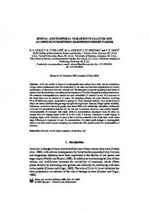
Diversification of rural economy in terms of percentage of overall rural non-agricultural worker, rural male and female non-agricultural workers are also important demographic indicators of any region. Because with the process of development, the share of non-farm income and employment in the total income and employment of the rural households increases. Rural non-agricultural workers as percent of total rural workers is maximum in Darjiling district (53.35 percent) and minimum in Dakshin Dinajpur (17.37). The next indicator is sex ratio which is an important structural aspect of population and is the relative numbers of males and females. Generally, slightly more males are born than females (a typical ratio would be 105 or 106 males for every 100 females). On the other hand, it is quite common for males to experience higher mortality at virtually all ages after birth. This difference is apparently of biological origin. Exceptions occur in countries such as India, where the mortality of females may be higher than that of males in childhood and at the ages of childbearing because of unequal allocation of resources within the family and the poor quality of maternal health care. Highest sex ratio is found in Darjiling district (970) and lowest found in Purba Medinipur (938). Rural sex ratio is also maximum in Darjiling district (973) and minimum in both Cooch Behar and Purba Medinipur districts (939). Child sex ratio reflects both, pre-birth discrimination manifested through gender biased sex selection, and post birth discrimination against girls. The maximum child sex ratio is found in Murshidabad (968) and minimum in Purba Medinipur (946). The last indicator is percentage of main worker to total worker, higher the percentage of main worker means more stability in economic and social life. The district of Nadia (86.6 percent) has the highest percentage of main worker while Puruliya has minimum percentage of main worker i.e. only 49.1 percent. After calculating Composite Standard Score (CSS), the 18 districts were categorized in three levels to identify disparity in demographic development. Figure 1 shows the spatial dimension of demographic development in West Bengal (2011). It is found that only 4 districts are lies in high category. These are Darjiling (1.04), Howrah (0.81), North 24 Parganas (0.71) and Hooghly (0.55). This group covers 22.22 percent of total districts. The main reasons behind the development of Darjeeling hill area are tea production, horticulture, forestry and tourism. Since its beginning, the tea industry has played a pivotal role in the socio-economic lives of people of the
region by providing direct employment to thousands of households and ancillary jobs to many more thousands in chest-tea, plywood, tea packaging and other tea-related trades. Tourism is also an important economic activity of hill areas of Darjeeling District generating incomes and employment for the local population. Darjeeling receives around 3.5 Lakhs domestic tourists and 50,000 foreign tourists per year that generates near 30 percent of total tourism business of the region worth around Rs 350 crore per annum. Everybody right from a chaiwala up to the hotel owner benefits from the tourism. Apart from an increase in the income and the demand for local products, tourism also results in a multiplier effect. Moreover, the a larger part of Siliguri, the second largest city in west Bengal lies within this district [21]. Howrah is the second most developed district in the state. About 64 percent of its population live in urban areas. The economy of Howrah is predominantly industry dependent. Recently Howrah witnesses a lot of industrial proposals in its core. The district is making economic progress with the mushrooming of both the small & large- scale industries. Salkia, in Howrah is the abode of the ship making industry in India. Hooghly Docking and Engineering Works (Salkia), Shalimar Works (Shibpur), Port Engineering Works (near to the Botanical Garden) etc are the traditional industries in the districts, established in the British regime. These industries supports the domestic economy and at the same time accounts for the large quantity of export while enhancing the overall economy of Howrah. The reason for the development of Hoogly is that About 70 percent of the population derives their living from the agriculture and therefore Hooghly holds one of the remarkable positions in the arena of agriculture. The regional topography, with an average elevation of about 200 meters, drained by river Hugli and Damodar offers a favorable landscape for agriculture. Similarly, agriculture is the main stay of the people of North 24 Parganas. The regional homogeneity with the sufficient rainfall is conducive for the prosperity of Agriculture. Agriculture supports the economy of North 24 Parganas, on a large scale. Rice, jute, coconuts, potatoes, wheat and rapeseed are the principal crops produce here. Lastly, close proximity with the metropolitan city Kolkata, supports the economy of Howrah, Hooghly and North 24 Parganas to a large extent. A bulk of people of these districts draw their living from the industrial sectors in the core of Kolkata.
Table 2: Levels of Demographic development in West Bengal CSS Range
No of District
Percentage of the Total District
High
Above +0.35
4
22.22
Darjiling, Hooghly, Howrah and North 24 Parganas
Moderate
Between 0.35 and -0.34
50
Jalpaiguri, Dakshin Dinajpur, Murshidabad, Burdwan, Birbhum, Purba and Paschim Medinipur, Nadia and South 24 Parganas
27.78
Cooch Behar, Puruliya, Bankura, Maldah and Uttar Dinajpur
Category
9
Low Below -0.34 5 Source: Computed by the Authors
Name of the Districts
140
International Journal of Academic Research and Development
Out of 18 districts 9 districts lie in Moderate category of demographic development which CSS value varies from +0.35 to -0.34. These districts are South 24 Parganas (0.31), Nadia (0.24), Murshidabad (0.25), Jalpaiguri (0.17), Paschim Medinipur (0.15), Dakshin Dinajpur (0.11), Burdwan (-0.13), Birbhum (-0.20), Purba Medinipur (-0.31). Burdwan is one of the district of West Bengal that is privileged in both agriculture & industry. Hence both supplement the economy of the district. On a whole about 58 percent of the population draw their living from agriculture and remaining 42 percent of the district's economy is supported by the non-agricultural sector. Agriculture, Industry and Pisciculture are all at their peak in South 24 Parganas. The economy of Jalpaiguri is essentially agriculture-based. Moreover the staple resources of the tea industries are tealeaves, which are also cultivated. The physical homogeneity of the central and the southern part of the district is formed of alluvium and the silt carried by the rivers like Teesta, Mahananda, Torsha, etc. All these are originated from the northern glacier- hence perennial; they provide continuous water to the region for the growth of agriculture. The conducive landscape with the continuous supply of water is favorable for the cultivation of rice. Rice is the principal crop of the district, though the major part of its production is meant to serve the domestic requirement. Wheat also shares a position in serving the local economy of Jalpaiguri. Birbhum is also primarily an agricultural district with around 75 percent of the people dependent on agriculture and it is a major centre of cottage industries in India.
There are five districts in the category of low development in terms of demography. The least developed districts are Uttar Dinajpur (-1.03), Maldah (0.83), Puruliya (-0.79), Bankura (-0.44) and (-0.39). Uttar Dinajpur is placed among the least developed districts in West Bengal as well as in India, with high levels of illiteracy, low health-care and livelihood access and wide-spread rural poverty. Although it is a predominantly agricultural district, rapid population escalation restricts the absorption of new rural workers into farm-based employment, while low levels of urbanisation restrain the growth of the non-farm sector. The economy of Cooch Behar district is solely agriculture-dependent. In spite of having a huge raw materials, due to the lack of proper infrastructure the industrial sector is not well developed here. The literacy rates (74.8 percent) of males and females are 80.71 percent and 68.49 percent respectively. The rate of work participation is 40.01percent (58.24 percent male and 20.67 percent female) and in this case Cooch Behar ranks 5th in the State. Due to the rough weather and soil, Puruliya lags behind in agricultural arena from the other districts of West Bengal. However cultivation of silk and lac are the main agricultural products. Bankura is economically underdeveloped and is mostly dependent on agriculture. Almost 70 percent of the district's income is generated through agriculture where 80 percent of the farmers are small & marginal in nature. Bankura is one of the most draught prone district of West Bengal.
Table 3: Composite Standard Score (CSS) of the variables for the Demographic development in West Bengal Districts
Indicators X1
X2
X3
X4
X5
X6
X7
X8
X9
X10
X11
X12
CSS
Darjiling
0.88
0.69
0.66
0.43
2.22
0.94
1.92
1.89
2.05
0.67
-0.41
0.54
1.04
Jalpaiguri
0.15
-0.12
-0.17
-0.22
0.90
0.38
0.80
0.09
0.39
-0.45
-0.07
0.37
0.17
Coochbehar
-0.87
0.07
0.03
0.17
-0.76
-0.26
-0.94
-1.08
-1.47
1.06
-1.24
0.61
-0.39
Uttar Dinajpur
-0.77
-1.92
-1.82
-2.13
-0.74
-0.33
-0.44
-1.40
-1.27
-1.52
-0.41
0.41
-1.03
Dakshin Dinajpur
-0.64
-0.18
-0.04
-0.11
-1.09
-0.45
-0.87
0.41
-0.13
1.30
0.26
0.23
-0.11
Maldah
-0.67
-1.59
-1.31
-1.65
-0.23
-0.17
0.16
-0.87
-0.44
-1.90
-0.90
-0.43
-0.83
Murshidabad
-0.31
-0.97
-0.65
-0.89
0.04
-0.16
1.41
0.62
0.18
1.06
2.09
0.56
0.25
Burdwan
0.90
0.25
0.26
0.27
-0.36
-0.13
-0.48
-0.76
0.08
-0.98
-0.74
0.18
-0.13
Birbhum
-0.72
-0.45
-0.44
-0.35
-0.79
-0.34
-0.62
0.41
0.18
0.52
0.59
-0.40
-0.20
Bankura
-0.99
-0.50
-0.76
-0.25
-0.88
-0.28
-1.12
0.51
0.29
0.77
-1.07
-1.01
-0.44
Puruliya
-0.72
-1.23
-1.84
-1.18
-0.84
-0.19
-1.11
0.51
0.70
-0.79
-0.41
-2.35
-0.79
Nadia
0.18
0.10
0.44
0.07
0.07
-0.27
1.38
-0.55
-1.27
0.57
0.76
1.41
0.24
Howrah
2.31
1.15
1.23
1.08
2.14
0.92
1.28
-1.40
-0.02
-0.98
1.09
0.97
0.81
Hoogly
0.83
0.96
1.03
1.04
0.35
0.23
-0.37
0.94
1.53
-0.11
-0.57
0.71
0.55
Paschim Medinipur
-0.76
0.48
0.28
0.68
-1.08
-0.37
-1.17
1.47
1.22
1.06
1.26
-1.24
0.15
Purba Medinipur
-0.79
1.62
1.36
1.87
-0.17
-0.03
-0.50
-1.50
-1.47
-1.13
-1.57
-1.36
-0.31
North 24 Paragans
1.95
1.25
1.44
0.78
0.68
0.25
0.64
0.30
-0.64
0.43
0.09
1.31
0.71
South 24 Parganas 0.05 0.41 Source: Computed by the authors
0.29
0.40
0.55
0.27
0.04
0.41
0.08
0.43
1.26
-0.50
0.31
141
International Journal of Academic Research and Development
Fig 1: District wise Levels of Demographic Development based on Composite Standard Score
5. Conclusion Development is a multi-faced process by which a nation improves the economic, political, and social well-being of its people and it has spatio-temporal dimension. In this paper, district level disparity in West Bengal in terms of demographic development has been analysed taking into account 12 indicators related to urbanisation, liter acy, sex ratio and diversification of rural economy. The 18 districts were categorized in three levels of development. The most developed districts are Darjiling, Howrah, Hooghly and North 24 Parganas while the least developed districts are north Dinajpur, Maldah, Puruliya, Cooch Behar and Bankura; the remaining 9 districts are in moderate category. So, significant disparity found among the districts of West Bengal in the level of demographic development. This imbalances are causes due to improper distribution of different infrastructural facilities for the common people. the disparities create the forces of discontent and disintegration in the society. Reducing regional disparities and achieving balanced regional development, is the core content of contemporary regional policy. Decentralized distribution of infrastructural investment can minimize regional imbalances. Therefore, planners have to give much importance upon decentralized planning process based upon intensive study of micro level region in assessing the gap of planning strategy and promote balanced regional development.
6. References 1. Chandana RC. Geography of population: Concepts, Determinants and Patterns, Kalyani Publication, New Delhi, 2002. 2. Mitchell B. Geography and resource analysis (No. Ed. 2). Longman Group Limited, Longman Scientific & Technical, 1989. 3. Barbier EB. The concept of sustainable economic development. Environmental conservation. 1987; 14(02):101-110. 4. Bhattacharya BB, Sakthivel S. Regional growth and disparity in India: Comparison of pre-and postreform decades. Economic and Political Weekly, 2004, 1071-1077. 5. Sam K, Chakma N. An Inter-Block Level Analysis of Regional Disparity in the Youngest Alipurduar District of West Bengal. Space and Culture, India, 2016; 3(3):10-20. 6. Dholakia RH. Regional disparity in economic and human development in India. Economic and Political Weekly, 2003; 4166-4172. http://www.mimts.org/journal_income/39Regional%20Disparity%20in%20Economic%20and% 20Human%20Development%20in%20India.pdf 7. Pal P, Ghosh J. Inequality in India: A survey of recent trends. Economic and Social Affairs Working Paper, 2007.
142
International Journal of Academic Research and Development
8.
9.
10.
11.
12.
13.
14.
15.
16.
17.
18.
19.
20.
21.
http://www.chereum.umontreal.ca/activites_pdf/Sessi on%201/Inequality%20in%20India%20(1).pdf Das SK, Barua A. Regional inequalities, economic growth and liberalisation: A study of the Indian economy. The Journal of Development Studies. 1996; 32(3):364-390. Sachs JD, Bajpai N, Ramiah A. Understanding regional economic growth in India. Asian Economic Papers. 2002; 1(3):32-62. Jha R. Reducing poverty and inequality in India: Has liberalization helped?. United Nations University, World Institute for Development Economics Research, 2000. https://ccep.crawford.anu.edu.au/acde/publications/p ublish/papers/wp2002/wp-econ-2002-04.pdf Sharma R. Regional Disparities in the Levels of Agricultural Development in Aligarh District of Western Uttar Pradesh. International Journal of Scientific and Research Publications, 2014; 4(8):1-8. Singh G, Ashraf SWA. Spatial variation in level of agricultural development in Bulandshahr district of western Uttar Pradesh (India). International Journal of Development and Sustainability. 2012; 1(1):47-56. Ohlan R. Pattern of regional disparities in socio economic development in India: District level analysis. Social Indicators Research. 2013; 114(3):841-873. Sarkar BC. Role of socio-economic factors on imbalanced regional development in West Bengal, India. Journal of Geography and Regional Planning. 2013; 6(1):10-18. Cherodian R, Thirlwall AP. Regional disparities in per capita income in India: convergence or divergence?. Journal of Post Keynesian Economics. 2015; 37(3):384-407. Reddy AA, Bantilan MCS. Regional disparities in Andhra Pradesh, India. Local Economy. 2013; 28(1):123-135. Caldwell JC, Reddy PH, Caldwell P. The causes of demographic change: experimental research in south India, 1988. Yadav SJ, Sharma U. Regional Disparities in the Levels of Demographic Development in Haryana2001. Shodh, Samiksha aur Mulyankan- International Research Journal. 2009; 2(6):5-9. Bohrnstedt GW. A quick method for determining the reliability andvalidity of multiple-item scales. American Sociological Review, 1969, 542-548. Heise DR, Bohrnstedt GW. Validity, invalidity, and reliability. Sociological methodology. 1970; 2:104129. Bhutia S. Economic development and environmental issues in Darjeeling Himalaya of West Bengal, India: a theoretical perspective. Int J Hum Soc Sci Invest. 2014; 3(7):42-47.
143