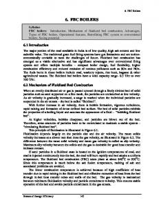
(Smart Code. Version 9.2). Figure 2. Transect diagram with six normative Transect Zones (T- zones) used for the zoning of urban areas as well as natural lands.
Form-based Code (FBC) Modelling for Urban Design of High-dense Cities Yingyi Zhang and Marc Aurel Schnabel Victoria University of Wellington Wellington, New Zealand {yingyi.zhang, marcaurel.schnabel}@vuw.ac.nz ABSTRACT
This research explores Form-Based Code (FBC) modelling and its impact on urban design of high-dense cities. Our paper consists of three parts. First, we discuss the context and components of FBC methodology. Although originating from zoning, FBC is totally a new approach in urban planning and design, which mainly lays emphasis on “form” instead of “land-use”. Second, we present the process of creating FBC models. There are five elements in FBC implementation, Regulating Plan, Public Standards, Building Standards, Administration and Definitions. Modelling FBC has three phases, documenting, visioning and assembling. Last, we end with a pilot study in Hong Kong. There is no real practice of FBC in high-dense cities, however, we argue the potential and challenges of FBC application in high-dense cities through the hypothesis of FBC model making in the case of Hong Kong. Author Keywords
Form-based Code; modelling; urban design; high-dense; Hong Kong. ACM Classification Keywords
I.6.5 MODEL DEVELOPMENT (modelling methodologies). 1
INTRODUCTION: FBC, “A NEW APPROACH"
Rigid segregation zoning was a predominant way of creating urban planning in America in past century. It regulated the structural framework and space typologies in both urban and rural areas. Zoning generally became a practical tool assisting governments and planners to avoid ‘inappropriate’ building-scale and urban construction. Following after the zoning theory, form-based codes developed into an innovative design reform basing on Smart Growth, New Urbanism and Transect. Form-based Code, FBC for short, is a land development regulation that fosters predictable built results and a high-quality public realm by using physical form (rather than separation of uses) as the organizing principle for the code [3]. Compared with zoning, FBC advocates to take land use, pedestrian space, streetscape and neighbourhoods into code-making parameter system. In conventional zoning, land use is primary consideration; while in FBC, physical SimAUD 2016 May 16-18 London, UK © 2016 Society for Modeling & Simulation International (SCS)
147
form and character are primary considerations [4]. In 2008, Parolek et al raised the relationship and differences between zoning and FBC (Table 1). The main purpose of FBC creating is to suggest unique ways to preserve or shape urban form, especially in public realm, for each specific planning site. Form-based code works as a regulation adopted into city, town, or county law, which offers a powerful alternative to conventional zoning regulation [3]. To some extent, FBC can be regarded as a valid approach to resist the urban assimilation under the unrestrained globalization. Conventional zoning
Form-based Codes (FBCs)
Land use is primary consideration.
Physical form and character are primary, with secondary consideration to use.
Segregated land-use planning principles.
Mixed use, walkable, compact development oriented principles.
Districts
Neighbourhoods/streets.
Organized around land use zone.
Used spatial organizing principles to reinforce urban hierarchy.
Reactive to individual development proposals.
Proactive community visioning.
Proscriptive, regulating by numeric parameters E.g. Plot ratio, setbacks, parking ratios. Regulate to create buildings Focus on sites, right-ofway. Uniformity in neighbourhoods.
Prescriptive, describe the requirement.
Regulate to create places Attention on street and streetscape. Diversity in neighbourhoods.
Table 1. Comparison of conventional zoning and FBCs [8].
The core of FBC modelling is the so called “Smart Code”, which addresses all scales of planning, from the region to the community to the block and building [9]. In form-based coding procedure, transect code always represents form
code. Because transects show actual development requirements such as building location, set back lines, or allowable building heights [6]. Basing on transect investigation and environment analysis, Smart Code was developed in the 20th century. A transect of natural landform is intended to express a sequence of environment (Figure 1), analogously, humans also need a system that (re-)create portions in their habitat conditions (Figure 2). In this way, the basic of Smart Code is developed. The ruralto-urban transect is composed of six zones (T1-T6), and these zones are various in different physical and social characters. After FBC makers’ analysis of site contexts, Smart Code modelling is manipulated, aiming to control urban spaces, patterns and frameworks, as well as simulate future urban forms and developments.
on, form-basing takes up the vital coding principle in the whole planning and design process. FBC has been used in the down town mixed use master plan in Benicia, 23rd Street corridor design in Richmond, Hercules waterfront TOD master plan and Loma Rica ranch specific plan and other hundreds of projects. In general, making FBC needs five main elements and three phases. 2.1 Five Main Elements in FBC
Layouts in FBC are expressed by words, diagrams, models and other visuals in multi-scale and transect-based regulation. FBC is established mainly by five elements. They are Regulating Plan, Public Standards, Building standards, Administration and Definitions. Besides, there are some additional optional elements, such as Block Standards, Landscaping Standards, Signage Standards, Environment Resource Standards and Annotation. Regulating Plan
Following the transect classification, regulating plan delimits the geographic areas and designates the locations where various building form standards should be applied. Regulating plan is vital in the whole FBC making process.
Figure 1. Typical Transect of Natural Landform. (Smart Code Version 9.2)
Figure 2. Transect diagram with six normative Transect Zones (Tzones) used for the zoning of urban areas as well as natural lands [1]. 2
ELEMENTS AND PROCESSES OF FBC
The original intention of FBC is to be used in the redevelopment of design scenarios. Some scholars also equal “form-based” to “design-based” [12]. Through a series of applications and implementations by architectural praxis, urban designers and planners in the USA, FBC began to be seen as a place-making plan methodology, such as renewal in neighbourhoods, regulating urban constructions, creating road networks and shaping high quality public realm. The Seaside Urban Code in Florida (1986) [10] is one of the most typical projects using “code” concept in urban planning in the early stage of urban coding practice. It’s a courtesy of Duany Plater-Zyberk & Company (DPZ). The seaside code included setbacks, lots lines, yards, porches and balconies, and parking. From then
The regulating Plan has three goals. First is Administration. Interfaces of the regulating plan assign different developing standards, meanwhile provide an appropriate commencement for people to recognize and use FBC tests and imageries. Second is Direct Regulation. Regulating plan has the responsibility to present practical developing demands, like special architecture design or atypical façade. Third is Planning. Making regulations for development or redevelopment contribute towards the master plan vision. It is an inevitable portion of urban design research. These regulations describe the characteristics and forms of regions, which is important to ensure the urban growth matches the goals outlined in communities. Regulating plan becomes the cornerstone of public realm construction in FBC. Public Standards
The quality of urban space is largely influenced by public streets, parks, squares, sidewalks and other public spaces. Public standards are the core elements of FBCs. There are two portions in public standards, thoroughfare and civic spaces. Thoroughfare controls the standards of circulation space interface. Road facilities, including road green belts and transport functional squares, contribute 20%-40% in gross urban constructed land. So thoroughfare design is a key element in FBC. Most of FBC making procedures tend to create road standard system to approve qualified urban road network. Besides, the intersections between physical place-making and social activities are also important to public standards. Civic spaces act as a role of this kind of “intersection”. Civic spaces contain parks, squares, markets and playgrounds. They enhance to the characteristics of civic realm visually and emotionally. Public standards contribute
148
to the framework for civic communication and social activities, which is meaningful for community healthy both economically, culturally and environmentally.
spaces; signage standards set the signage sizes and placement. 2.2 FBC Making Process
Building Standards
Building standards mainly describe the physical form of buildings and building environments, like features, configurations and functions of buildings which define and regulate public spaces. Typical building standards specifically contain building’s position and form, function, car parking, land-use and frontage type, as well as building typologies and styles. Through FBC regulating, most buildings of communities have corresponding guides for design and construction. Building standards are benefit to reconcile the complicated relationships between public and private spaces.
The process of creating FBC is a key point in controlling practice and implementation. It is fundamentally differ from traditional zoning methodology. FBC processes contribute to the public participant no matter in urban design scenarios or community policies development. The processes can be divided into three phases, documenting, visioning and assembling (Figure 3).
In FBC methodology, the forms of buildings are the most important basis for classification rather than building function. Form takes priority over all other urban design contents. In conventional zoning era, the pursuit of density and plot ratio makes developers to fill buildings simply into regions to meet the required value of number. Blindness filling urban space gives into economic demands at the cost of form context and urban fabric. On the contrary, building standards regulate a series of building types to create lively, humanly, form-based urban space. Figure 3. FBC creating processes [8]. Administration
Public and private institutions are necessary to collaborate and implement a community FBC plan together, especially in administrative procedures of examining and authorizing. As a new design and plan method, FBC formulate form standard, not just advising, to fulfil the development requirements in different communities. It needs a clearly defined application and examination mechanism. David Walters considered the inability of design standards to take hold bears witness to the fact that guidance was not enough. As in America, the detailed rules, or codes, that govern urban development is supposed to be changed. Unfortunately, good design needs to be mandated, not simply encouraged [12]. After making the regulating plan, FBC has to contain some compulsory measures, under the legal force and local policies, to guarantee the cogent implementation in community development.
Documenting
Definitions
By gathering the physical environment data, designers can create an existing conditions map to summary physical form and patterns. In a smaller scale, designers need to collect more details in the existing conditions map. Basic elements are varieties depended on different communities, like buildings (types, functions, placements and forms), public spaces (parks, gardens and plazas), architecture and landscaping. Once the documenting is completed, designers value these collected forms and determine which are most representative of typical conditions. The basic forms are the measurements for practical FBC system.
Definitions work as appendices of a FBC version. They help to ensure the technical terms are used precisely in practice. Besides the main five elements, there are some other relevant aspects also important. They are not so dispensable in FBC model making, however, they are part of enhancing the success of implementation. For example, architectural standards regulate the façade of buildings, windows and doors, details and materials; landscaping standards describe the plant materials on private property as they impact public
149
Before creating FBCs, designers need to identify the unique characteristics of a community from existing form. This phase is documenting. Data collected during documenting phase is analysed to support the creation of FBC. In a subareas scale, designers may begin with the neighbourhoods, districts and corridors. Neighbourhoods are always unified in character and have clearly centre, edge and style tendency. These help designers know more about the composition of the target community. Districts are considered as specified functional areas where human’s public activates happened, such as industrial districts, commercial districts and residential districts. Corridors contain roads, railways, highways, even rivers. They are always acting as boundaries in one neighbourhood unit or between different neighbourhoods.
Vision
In the second phase, the vision of target community should be defined in details by FBC. The main coding purpose is to predict outcomes of the built environment, “vision” is required for setting a clear goal for the desired outcomes. There are two ways to understand a community’s vision. One is through gathering background plans or comprehensive maps. Communities may already made their vision clear in them. The other is through public participation – talking to residents and community council to come up with a specific vision for their future. After knowing the community vision, designers proceed to create the FBC system with the reliable foundation. Vision phase contains three steps. First is illustrative plan and imagery. Illustrative plan shows the imagery distributions in future, including neighbourhood, districts and corridors. The models of public space, buildings and road lines also can be included in it, which depend on the required scope and research depth. Designers are supposed to put some unique or characteristic elements into vision sheet by valuing these data. Second is coding. Once the vison sheet is placed in, transect, micro-scale matrixes and administration review process constitute the regulation plans. Last but not least, administrative review help to define the follow-up procedures and make community know more about future environment. In this phase, designers adjust or refine the program and coding grammar continuously to fulfil the urban development goals.
dense” is one of the most typical form characteristics of the fast developing processes. Some researchers propose it is a social problem that high-dense cities lead to high crime rate, traffic problems and the lower quality of living environment. For most high-dense cities, the limitation of topographic condition makes high-dense form become an inevitable choice. The gross area of Hong Kong is more than one thousand km2, the average population density is about six thousand or more per kilometres. Because of the natural environment condition, Hong Kong only has about 15% gross area can be constructed [2]. As mentioned above, FBC modelling provides the possibility to rethink the urban form and planning in a rational way that allows for more flexibility and adjustment “on the go” that is more suitable for dynamic and rapidly developing cities. Can we employ FBC as a pilot tool to controlling and (re)coding high-dense cities’ development? Applying the FBC methodology into the intrinsic urban planning mechanism of Hong Kong is not just a simple replacement. Government and planners have to engage in a variety of demonstrations, discussions, and even improper attempts. We argue the opportunities of making FBC in Hong Kong and present specific ways to guide implementation. Before making FBCs, a rural-to-urban transect has to be prepared, which describes basic information of neighbourhood features and architecture diversity. Hong Kong does not have a common pattern that can be summarized in a single district. Figure 4 shows a rough territorial-wide transect from rural to central area.
Assembling
Different from 2D outcomes of conventional zoning, FBC is more conciseness and understandable. In the last phase, designers translate FBC layouts into visual 3D models to offer interfaces for public participations, which is userfriendly and interactive to space users of a community. Nowadays, developing Parametric models to support FBC expression gains increasing attentions. Digital tools, like BIM, GIS and CityEngine, provide smart platform for both designers and space users. Because of the flexibility of the FBC digital models, designers can renew or alter programs, layouts and typologies based on the public comments. The final formatting layouts usually contains content, acknowledge, regulating plan, building standards, street standards, public space model, administration, definitions and other appendixes. 3
A STUDY OF HONG KONG
FBC theory is still developing. There is nearly no attempts in high-dense urban areas. Yet, high-dense cities are in much greater need of efficient, interactive and smart approaches to analyse, predict and guide urban development. Subsequently, the FBC methodology has great potentials of making a contribution in high-dense built environments.
Figure 4. Territorial-wide Transect of Hong Kong [4].
The development situation in the core of Hong Kong Island differs from the suburbs, irregular small scale figure ground of Sai Ying Pun region and regular big scale figure ground of Sham Shui Po are totally different (Figure 5). It is a challenge to generalize the six transect zones as Parolek et al mentioned in Form-based Code: A Guide for Planners, Urban Designers, Municipalities, and Developers.
For our research, we choose Hong Kong as a study case. Hong Kong has been built in a very short time [12], “high-
150
Compared with the loose form towns and cities, sustainable, connective and pedestrian friendly urban forms are more important standards for concentrated cities. Sustainability is defined as meets the needs of the present without compromising the ability of future generations to meet their own needs [12]. FBC helps to set standards of urban forms which meet the sustainable community visions, and in this way, avoids aimless construction and unsustainable development. In the next research step, coding in a specific street region in new town of Hong Kong by using form and making a criteria system for the implementation of FBC in Hong Kong are necessary. Besides, connectivity and pedestrian friendly are both elements in transportation. Road system is skeleton and transportation is blood of a crowded city. High-dense city will not operate organically without well-organized road system. In Hong Kong, FBC is also expected to improve road standards, not only for motor vehicles and public transportations, but especially for bike riders and pedestrians.
Figure 5. High-dense neighbourhoods in Hong Kong. Row by row from top, left: Tsuen King, Tai Koo, Sham Shui Po and Chi Kiang Street; Right: North Point, Sai Ying Pun, Tai Po and Fuk Loi [5].
Minimizing the research scope to specific streets, designers are able to create more accurate transect figures than in region scale. The FBCs work well for community development if the six transect zones is coincident with existing physical forms accurately. There are some attempts of making FBC standards basing on existing streets and buildings in Wanchai and Shatin showed in Figure 6. They are the only attempt of FBC in Hong Kong, which designed by Kan at the Hong Kong University in 2012 [4]. In Alvin’s research, complicated streetscape was simplified into a few types. There is no practical assessments for the design hypothesis. Coding in high-dense cites like Hong Kong needs more consideration about people’s impressions and experiences of a specific street space and the behaviours to environment. As a super city with especial historical background and developing time, Hong Kong is unable to avoid urban expansion with its growing population, followed by the construction of new towns and renewal of old centres of city. Urban coding based form is appropriate to be used into new town’s urban plan procedure, which not mentioned by Alvin, for FBC modelling is a rational way to regulate communities’ growth and control development of this metropolis. Through the classification of urban form, the street space has the opportunity to be simplified as regular cubes. That’s benefit to control developing tendency and predict maximum capacity of the population. Although in the last decade, population growth in Hong Kong began to slow down, the requirements of urban facilities, high quality public space, and the use of mountain areas, parks and wetlands have never receded in neighbourhood’s wish list.
151
Figure 6. Graphical Presentations of Streets of Wanchai and Shatin, Hong Kong [4].
4
CONCLUSION
FBC is an alternative approach and new angle to create design standards, evaluate community development and regulate urban extension through existing forms. Different from conventional zoning mechanism, which is simply place emphasis on land-use, FBC aims to collect data about physical form and characters with secondary consideration to use. Also, FBC modelling provides intuitive platform to designers and publics by using text, imagery and 3D scenarios instead of 2D zoning layouts. FBC’s consistent basing form towards to (re-)create diversity urban spaces. Under the force of globalization, urban contexts and form characteristics, especially in Asian cities, are becoming crucial applications of FBC in order to generate sustainable and liveable city areas. FBC modelling has the potentials to (re-)create well-founded, executable urban space. To some extent, that’s an effective way to keep features of historical segments of a city. As a new methodology, the implementation of FBC is still at the early stage of development. There is no mature practice in high-dense cities until now. Different designers and investigators have different understandings of transects and building forms. How to compromise the divergences and optimize FBC standards need a more comprehensive FBC modelling mechanism. That will be challenging in future study.
3. Form-based Codes Institute (FBIC). http://www.formbasedcodes.org/. As of 15 September 2015. 4. Kan, A.C.H. From-based urban planning code and implications in Hong Kong. Master’s thesis of the University of Hong Kong, 2012, 100-106, 122-132. 5. Kandt, J. Hong Kong’s spatial DNA. Cities, health and well-being, Hong Kong Urban Age Conference, LES Cities, UK, 2011. 6. Kim J.B. and Clayton, M.J. Support Form-based Codes with Building Information Modelling – The Parametric Urban Model Case Study. ACADIA 10: LIFE in:formation, On Responsive Information and Variations, 2010, 133-137. 7. Marshall, S. Urban Coding and Planning. Routledge, Oxfordshire, UK, 2011. 8. Parolek, D.G., Parolek, K. and Crawford, P.C. Formbased Codes: A Guide for Planners, Urban Designers, Municipalities, and Developers. Wiley, USA, 2008. 9. Smart Code Central. http://smartcodecentral.com. As of 15 February 2016. 10. The Codes Project. http://codesproject.asu.edu/node/115. As of 15 February 2016. 11. UCLA Sustainability, What is sustainability. http://www.sustain.ucla.edu/about-us/what-issustainability/. As of 15 September 2015.
REFERENCES
1. Duany, A. and Plater-Zyberk, E. (DPZ). Smart Code 9.2, The Town Paper Publisher. http://www.dpz.com/uploads/Books/SmartCodev9.2.pdf. As of 15 September 2015.
12. Walker, A. and Rowlinson, S.M. The Building of Hong Kong. Hong Kong University Press, Hong Kong, 1990. 13. Walters, D. Designing Community: Charrettes, Masterplans and Form-based Codes. Oxford, UK, 2007.
2. Fei, Y.S. and Wang, J.G. Urban form and transportation in a high-density city – take the development of Hong Kong as an example. New Architecture, 4(2004), 4-6.
14.Zhang, Y. and Schnabel, M.A. Form-Based Code in Parametric Modelling for Continuous Urban Design, Proc. Living Systems and Micro-Utopias: Towards Continuous Designing, CAADRIA, (2016)
152