From Automatic Sign Detection To Space Usage Rules Mining For Autonomous Driving Pavel Samsonov
Abstract
Expertise Centre for Digital Media
While there is a large body of related work on the automatic detecting of road signs for (semi-) autonomous vehicles, we believe that these vehicles should also be aware of so-called “space usage rules” (SURs) more generally. Vehicles that understand SURs – e.g. “no swimming”, “no drone flying”, - could provide a novel set of context-aware services for autonomous driving. For instance, an autonomous car navigation system could provide directions to the nearest beach, where swimming is allowed, or the system itself could know if it is allowed to send out its drone to get an overview on the current traffic situation ahead. In this workshop paper, we outline two techniques to mine these SURs. We present a visionbased technique and a technique utilizing user interfaces for encoding SUR expressed in natural language into a machine-readable format.
Hasselt University - tUL - iMinds
[email protected] Brent Hecht Computer Science and Engineering University of Minnesota
[email protected] Johannes Schöning Expertise Centre for Digital Media Hasselt University - tUL – iMinds
[email protected]
Copyright held by authors, 2015
Author Keywords Space usage rules; Context-aware applications; Map applications; (Semi-) autonomous vehicles.
ACM Classification Keywords H.5.m. Information interfaces and presentation (e.g., HCI): Miscellaneous. User interfaces; Graphical user
interfaces (GUI); Interaction styles.
Input
devices
and
strategies;
Introduction & Motivation SURs, which are broadly defined to be rules and regulations that are spatially-constrained in nature, range from everyday restrictions like “no parking between 8pm and 8am” to less common restrictions like “do not use the horn” [9]. Besides “traditional” traffic sign detection, which has been extensively researched in the field of computer vision ([1], [2], [7]), we believe that future (semi-) autonomous vehicles should incorporate SURs beyond traffic sign information in their systems to provide a safe and enjoyable travel experience. By incorporating SURs into automobile navigation systems, various other novel context-aware services for autonomous driving could also be easily implemented. The car itself could figure out “routes with nearby beaches to swim or surf” or “the next park, where I can walk my dog”. As space usage restrictions like “no swimming” or “no dogs” could also be posted on signs, we briefly describe our vision-based technique [9] below. For example, Renault recently announced a new car concept with a drone companion on-board 1. The drone can be used to observe and monitor the traffic situation ahead and feed the data from its patrols back to the navigation system. However, in order for its drone to be used, the car system needs to know if in its current position it is legal to fly a drone. In the U.S., the use of 1
http://www.theverge.com/2014/2/7/5389114/renault-kwiddrone-car-concept
drones is currently forbidden nearby airports and national monuments. Other and more complex dronerelated SURs apply in different countries and municipalities around the globe. As such, information about drone-related SURs needs to be included in such car’s navigation system. As it is unlikely that visual signs indicating dronerelated SURs will be posted next to the road, we propose a technique utilizing a system for encoding SURs expressed in natural language (in legal documents) into a machine-readable format. We are developing an “if-this-then-that”-style interface described later in this paper that allows people without programming experience to create these machine readable SURs, with the goal of enabling the crowdsourcing of SURs around the world. By applying both, we believe that it is possible to mine a large dataset of SURs that could be incorporated into car navigation systems to exploit novel context aware services and improve the driving experience.
Related Work In our previous work [10] we pointed out the lack of space usage rule (SUR) data in today’s online and mobile map services. While the vector geographical information in OpenStreetMap (OSM) has extensive coverage and high quality in many places (e.g. [4] and [8]), space usage rule OSM tag data such as “no smoking” and “no dogs” is very sparse. Less wellknown rules have even lower coverage. For instance, only 57 features in the whole world in OSM are tagged as “no-fishing”. Gathering SUR information represents a hard and very expensive task, and the information needs to be updated relatively often.
Two methods how to gather SUR In this workshop paper, we propose two ways to collect SURs: a vision-based technique and a technique utilizing user interface for encoding SURs expressed in natural language into a machine-readable format. The vision-based technique will be also presented at the main CHI conference [9]. A vision-based approach to gather SUR As noted in the introduction, modern car navigation systems should be aware not just of the limitations on the roads, but also of the limitations in the destination points and the surrounding areas. The more information is available, the better the services that can be provided to the user. Examples include limitations in the entertainment or leisure facilities as noted above (e.g. no swimming, no dogs in certain parks) as well as information about parking places and so on. All this information can be retrieved from signs in the environment. Our vision-based approach identifies SUR signs data in geotagged photos published on public image sharing resources such as Flickr 2 and assigns them to geographical features. This SUR mining approach is fully automatic. First, geotagged images are crawled from the Internet and processed to find SUR signs in them. Then, the extracted SUR signs are mapped to a geographical feature in OSM. For a detailed overview on this technique we please refer to [9].
2
http.flickr.com
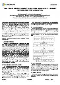
Figure 1. The if-this-then-that interface.
A user interface for encoding SUR expressed in natural language into a machine-readable format. In the introduction, we discuss that some signs, such as “no drones allowed”, are not posted, so they cannot be extracted from images. Therefore, we are developing a user interface to support the semiautomatic encoding of SURs expressed in natural language in documents such as laws, city ordinances, park rules, and institution FAQ pages. With the help of this “if-this-then-that”-style interface (see Figure 1) the conversion of a SUR expressed in natural language can be directly done by people not familiar with programming. We hope to deploy this interface to crowdworkers on Mechanical Turk in the near future. Our system works by converting user-entered SURs into Lua code. The system then maps the rules expressed in Lua to the appropriate geographic regions (using geographic data from OpenStreetMap). This information is then written into a database, which could then be easily imported into a car navigation system. We are also working to partially automate this process
using lightweight natural language processing and geoparsing (e.g. [3], [5]). As car navigation systems require highly accurate data, the data gathered with both methods needs verification before it can be used. Also, the data needs to be regularly checked for outdated rules and needs to be updated alongside the map data. We plan to assign each rule in the database a “trust level” mark, based on how many signs and rules state it to be true and the date of last modification. In the crowdsourcing case, several workers will be given the same natural language rule to check if they complete it in the same way.
Conclusion In this paper, we discussed why space usage rules could become an important component for automatic car navigation systems. Incorporating SURs in the databases of future (semi-) autonomous vehicles will provide a rich set of novel context-aware services for autonomous driving that will improve travel experiences. We have presented an automatic and a semi-automatic approach for gathering SUR data. We believe that combination of both techniques provides a good step forward for making SURs accessible for future autonomous vehicles.
References [1] Bahlmann, C., Zhu, Y., Ramesh, V., Pellkofer, M., & Koehler, T. (2005, June). A system for traffic sign detection, tracking, and recognition using color, shape, and motion information. Intelligent Vehicles Symposium, 2005. Proc. IEEE (pp. 255-260). [2] De La Escalera, A., Moreno, L. E., Salichs, M. A., & Armingol, J. M. (1997). Road traffic sign detection and
classification. Industrial Electronics, IEEE Transactions on, 44(6), 848-859. [3] Gelernter, J., and Mushegian, N. Geo-parsing Messages from Microtext. Transactions in GIS 15.6 (2011): 753-773. [4] Haklay, M. How good is volunteered geographical information? A comparative study of OpenStreetMap and Ordnance Survey datasets. Environment and planning. B, Planning & design 37.4 (2010): 682. [5] Hoffart, J., Yosef, M., Bordino, I., Fürstenau, H., Pinkal, M., Spaniol, M., Taneva, B., Thater, S. and Weikum, G. Robust disambiguation of named entities in text. Proc of EMNLP (2011). [6] Ierusalimschy, R., Henrique de Figueiredo, L., Celes, W. The Evolution of Lua. Proceedings of the Third ACM SIGPLAN Conference on History of Programming Languages, HOPL III, pp. 2-1-2-26. ACM, New York (2007). [7] Lopez, L. D., & Fuentes, O. (2007). Color-based road sign detection and tracking. Image analysis and recognition (pp. 1138-1147). Springer Berlin Heidelberg. [8] Mooney, P., Corcoran, P., Wistanley, A.C. Towards Quality Metrics for OpenStreetMap. Proceedings of the 18th SIGSPATIAL International Conference on Advances in Geographic Information Systems, ACM (2010) 514–517. [9] Samsonov, P., Tang, X., Schöning, J., Kuhn, W. and Brent, H. You Can’t Smoke Here: Towards Support for Space Usage Rules in Location-aware Technologies. Proc. CHI, ACM Press (2015). [10] Schöning, J., Hecht, B. and Kuhn, W. 2014. Informing Online and Mobile Map Design with the Collective Wisdom of Cartographers. DIS ’14.