Implementation of Geospatial Product Virtualization in Grid Environment Liping Di, Aijun Chen, Yuqi Bai, and Yaxing Wei Center for Spatial Information Science and Systems (CSISS) George Mason University 6301 Ivy Lane, Suite 620 Greenbelt, MD 20770
[email protected] Abstract- This paper presents the work performed for the implementation of the geospatial product virtualization in the Grid environment. A virtual geospatial product is a product that does not exist in a geospatial data system but the system knows how to create such a product when a user requests the product. We use a two-step approach to the implementation. The first step is to represent a virtual geospatial product by a geospatial processing model and the second step is to convert the model into an executable Grid service workflow and execute the workflow in Grid environment. A geospatial processing model tells conceptually how a type of geospatial products can be produced from raw geospatial data. The conversion from a geospatial processing model to an executable Grid workflow will incorporate the user specifications on the requested product into the workflow. This paper discusses the conceptual model for implementing product virtualization in the Grid environment, the overall architecture of the Grid virtual geospatial product system, service components developed and Globus components extended for the system, and operational considerations of the system. I.
INTRODUCTION
Significant progress has been made for the Earth science research and applications involving in collecting, analyzing and modeling with a huge amount of diverse distributed geospatial data. However, it remains a big issue for how to utilize domain experts’ knowledge to effectively and knowledgeably process those volumes of data step-by-step in geospatial analysis systems to extract information and knowledge products for applications and decision-makings. In concept, the step-by-step processes from the raw data to a user-specific product form an abstract geospatial processing model. The model represents the knowledge of geospatial domain experts on how to produce an application-specific product from available raw data sources. The processing model can be referred as Virtual Geospatial Product (VGP) that does not really exist, but is available when users request it [1]. When users request virtual geospatial product, the abstract processing model has to be firstly converted into concrete workflow that consists of concrete services and data distributed on the Internet, then, execute the workflow to get the application-specific product. During this procedure, many
services and huge volumes of data have to be involved to conduct computing- and data-intensive processing with the high-performance and high-throughout. In recent years, the Grid computing has become the prevailing information infrastructure to facilitate the efficient and effective utilization and sharing of the computing, storage, data, services and other resources dispersed on the Internet. The Grid technology enables the construction of computer networks that can function as a virtual supercomputer with great arithmetic capacities [2]. In a Grid, computers or clusters of computers are integrated using a completely new concept of data processing that leads to more transparent access to all kinds of new data and services. This development is about as important as the development of the World Wide Web: the invention has resulted in a mass of new research and has boosted worldwide integration of data, experiments and researchers. This is the way in which data is gathered and processed both in scientific experiments and in daily life. Therefore, Grid is an ideal platform for computingand data-intensive Earth science research and applications which involves many services and huge volumes of data [3]. Grid also has been widely used in bioinformatics, highenergy physics, astronomy, and other scientific disciplines. The Open Geospatial Consortium (OGC) is a non-profit international membership-based organization for promoting geospatial interoperability. It has developed a set of widely accepted web-based interoperability standards and protocols for processing and sharing geospatial resources in Earth science communities. The fundamental specifications for interoperable data discovery and access include Catalogue Service for Web (CS/W), Web Coverage Service (WCS), and Web Map Service (WMS). In the previous papers, we discussed the implementation of these services in the Globusbased Grid environment [4, 5]. These services provide fundamental catalog and data servings necessary for the construction, registration, instantiation, and execution of the abstract processing models discussed in this paper. The main focus of this paper is to discuss the concept, architecture, and implementation of the geospatial product virtualization in a Globus-based Grid system. Firstly, the concept of abstract geospatial processing models, which represents a VGP, is devised and expressed. Secondly, how a domain expert constructs an abstract processing model and registers the model in a catalog is detailed. Thirdly, a Business Process Execution Language (BPEL)-compliant instantiation service and Grid workflow engine are devised
and implemented for converting the abstract processing model into the concrete workflow and execute it in the Grid environment. Finally, the whole system architecture and its implementation are presented.
the output of the APM is Virtual Data Product, which belong to one of the DataTypes defined in the data ontology.
II. GEOSPATIAL ABSTRACT INFORMATION MODEL
We summarize the relationships between any two ServiceTypes as following: 1. Sequence: the output of ServiceType A is the input of ServiceType B. 2. Parallel: ServiceType A and B is parallel, both of their output are the input of the ServiceType C. We have designed an OGC-standard compliant Grid catalog system to register this abstract information model [6]. Experts retrieve ServiceTypes and DataTypes from the catalog for constructing APMs and register the APMs as virtual geospatial products. The catalog also registers the ServiceInstances and DataInstances. When a data user requests a product that is a virtual one, the instantiation service of the VGP system retrieves ServiceInstances and DataInstances from the catalog to convert the APM associated with the requested VPG to a concrete workflow. To general users who query the catalog to discover the availability of their requested products, there is no difference between real and virtual data products in terms of the behavior of the catalog.
A virtual data product is a product that does not exist in a geospatial data system but the system knows how to create such a product when a user requests the product. Therefore, the system can advertise the existence of the product without actually producing the product first. The product virtualization effectively allows a capable geospatial data system to offer unlimited numbers of products with a little effort. But how a virtual data product can be expressed with the domain experts’ knowledge? Here we adopt serviceoriented concept and propose a geospatial Abstract Information Model (AIM) for experts to express their knowledge for constructing geospatial Abstract Processing Models (APM). The AIM consists of the definition of DataType, ServiceType, DataInstance, and ServiceInstance, their registration to the catalog, and the possible logical relationships among ServiceTypes and between DataTypes and ServiceTypes. A. Definition of DataType
D. Logical relationships among ServiceTypes
III. THE CONSTRUCTION OF ABSTRACT PROCESSING MODELS
It only and must be defined according to the scientific terminology of a disciplinary domain, pointing out its scientific meanings of this kind of data, e.g. Digital Elevation Model (dtDEM), dtSlope, dtAspect, dtLandslide. The relationship among the data types is defined in the data ontology. B. Definition of ServiceType It only and must be defined by Input, Output and Operation. ServiceType’s Name, Input, Output and Operation are all defined within a disciplinary taxonomy so that the scientific meanings of this kind of services can be welled understood by the discipline. ServiceType’s Name is the Operation Name, e.g. stSlope, stAspect. The relationship between ServiceTypes is defined in the service ontology. We follow the rules: 1. Different Operation decides different scientific meanings. 2. Different Input results in different ServiceType. 3. Different Output results in different ServiceType. C. Definition of relationship between ServiceType and DataType The Input and Output of ServiceType are DataType. Because the output of any ServiceType is a DataType, and
Based on the above abstract information model, domain experts can create virtual geospatial products through construction of geospatial abstract processing models. A geospatial processing model tells conceptually how a type of geospatial products can be produced from raw geospatial data. It is an expression of geospatial processing knowledge possessed by a domain expert. Defining a virtual product by a geospatial processing model allows a virtual product system to quickly capture the domain knowledge of experts and convert the knowledge to available products. There are two steps for experts to construct the abstract processing model through a user-friendly web-based modeling graphic user interface (GUI) that we have designed and implemented. Firstly, experts construct the processing model with their domain knowledge. Secondly, experts register the model as a virtual geospatial product in the catalog of the VGP system for general user to retrieve in the future. The model, in fact, is a new service type that also can be used to construct new processing models in the future. The modeling GUI is designed based on the system catalog where the abstract information model, such as DataType, ServiceType, and their relationships, are registered. When an expert opens the GUI to start the modeling process, the interface retrieves all available DataTypes and ServiceTypes from the catalog and lists them on the interface. Now, experts select a DataType that their to-be-constructed model can generate. Then, they select a ServiceType that can produce
the DataType. Further more, they select new ServiceType whose output can be the input of the former ServiceType. Experts repeat the last step until they find the input of the last ServiceType is an elementary DataType who cannot be generated by a service (e.g., the raw remote sensing data), or a DataType whose corresponding DataInstances already exist. The above process creates a ServiceType chain, which is an abstract processing model. It represents domain experts’ knowledge on how to produce a specific geospatial product. Experts have to register this new model as a virtual geospatial product into the system catalog. It means that experts have to describe this new product with geospatial metadata by following the international geospatial metadata standard--ISO 19115. The metadata elements used to describe the virtual geospatial product include the name, applicable spatial and temporal range, basic attributes, etc. IV. GRID-BASED CONCRETE WORKFLOW AND ITS EXECUTION
Now, the virtual geospatial products are developed and registered. The next issue is how to materialize them in the Grid environment when users request instances of such virtual products. In order to materialize (produce) a virtual product defined by an APM based on users’ requirements, the APM has to be instantiated to become an executable concrete workflow, and execute the workflow by a workflow engine [7]. In this project, a Business Process Execution Language (BPEL)-compliant instantiation service and workflow engine service are devised in the Grid environment for converting the abstract processing model to a concrete BPEL workflow and executing the workflow through the workflow engine to generate the user-specific product. The concrete BPEL workflow is a Grid-service chain that consists of available optimized ServiceInstances and DataInstances. In the following subsections, we will introduce some Grid-enabled OGC Web services and extended Grid services since these services are fundamental and necessary for the abstractmodel instantiation and workflow execution. A. Grid-enabled OGC Web Services In this project, Grid-enabled OGC Catalog Service for Web (GCS/W), Grid-enabled Web Coverage Service (GWCS) and Grid-enabled Web Map Service (GWMS) were designed, implemented and deployed in the Grid environment [4, 5, 6, 8]. Based on the Grid CS/W service and Grid replica location service, we archive, manage, retrieve and optimize service instances and massive geospatial data. A Replica and Optimization Service (ROS) has been designed to improve the efficiency of data management and retrieval. In addition, Grid Security Infrastructure (GSI) based security approaches have been used in the system so that only authorized users can access all resources. GCS/W securely provides Grid-based archiving, publication, management, and discovery of the abstract
information model, virtual geospatial products, raw geospatial data, and service instances. It furnishes the transparent access to the distributed data and services and their replica in the Grid environment. The information model of GCS/W is based on that of OGC CS/W [9]. Any geospatial data/information can be registered with GCS/W and accessed by GWCS/GWMS in the Grid environment [5] [6] [11]. GWCS provides OGC standard interfaces, including getCapabilities, getCoverage, and describeCoverage, for other services to access geospatial coverage data in the Grid environment. It works as a basic service chained automatically into the concrete workflow by the instantiation service for providing geospatial data to other services. Any other Grid services and OGC standards-compliant client can access and interact with GWCS. A Grid-enabled Virtual WCS (GVWCS) is developed with the OGC WCS standard interfaces to accept all data requests from users. It automatically distinguishes the real data request from virtual data request, and sends the request to corresponding Grid services for further processing. GWMS is a geospatial Grid service that dynamically produces static maps from spatially referenced geographic information by filtering and portraying geospatial data based on client’s specifications. It provides the standard getCapabilities and getMap interfaces mandatory in the OGC WMS specification. . B. Other Extended Grid Services In order to implement the virtual geospatial product system in the Grid environment, additional Grid services, including the Grid Workflow Engine Service (GWES), Grid Instantiation Service, the intelligent Grid Service Mediator (iGSM), Replica and Optimized Service (ROS) and Data Transfer Service (DTS), have been developed or extended to work with the above mentioned Grid-enabled OGC services. The collaboration of these services in the Grid computing environment provides fast processing speed, good serving performance and quality, optimization of resources sharing for productions of geospatial products [3]. GWES and Instantiation service will be detailed later. iGSM is a Grid service that receives users’ request from GVWCS and coordinates ROS, GCS/W, GWCS and GWMS to generate the response [8] [10]. iGSM sends the user request, which includes the logical filename for the requested data, to ROS. ROS then use the logical filename to determine the best performing service that serves the requested real data product. Then, the Grid service is invoked by iGSM to retrieve the user-requested data. ROS is used to optimize user requests for data and services based on the Grid technology. It provides mechanisms for data replica management and the best service and data selection. ROS integrates the Globus Toolkit’s IndexService and Replica Location Service (RLS). The IndexService is used to retrieve dynamic information for every machine that hosts GWCS/GWMS. And RLS manages all distributed
replicas of every registered geospatial data. Through RLS, ROS gets the list of all machines that are able to serve userrequested data, and then selects the best machine according to the current situations of available computing resources of individual machines. When data transfer between two machines is required, DTS is invoked with the authentication operation. DTS works as a Grid service to be invoked by other Grid services when secure data transfer between different machines in the Grid environment is needed. This data transfer is highly secured through the use of Grid Security Infrastructure (GSI). Both a User certificate and a Host certificate are involved in identifying the authorization and authentication. GridRLS, Grid-enabled RLS, is based on the Globus RLS and works as a Grid service to enable RLS to orchestrate with any other Grid services. C. BPEL-compliant Grid Instantiation Service(GINS) The instantiation service is used to convert the abstract processing model into a concrete workflow when a user requests the virtual geospatial product. The concrete workflow consists of available Grid service instance and physically existed data in the system. Experts’ knowledge is taken into consideration for making sure the result is correct and meet user’s requirements. The instantiation procedure includes the following steps: 1) Acquiring optimized service instance and its WSDL: GINS takes the abstract processing model in the form of XML document and parses it to get all ServiceTypes in the model. The Instantiation Service queries GCS/W to get all available service instances for individual ServiceType. Then, for each ServiceType, ROS is invoked to select one service instance that can provide the best performance in the whole Grid environment. The WSDL file of the service instance is queried and returned. With the WSDL file, the mapping of parameters between any sequentially connected service instances is determined, which is used to produce the BPEL file of the abstract processing model. 2) Obtaining optimized physically existed data: GWCS is always used for serving the real geospatial data products that meet user’s query conditions. Therefore, GWCS is automatically chained into the workflow for serving the real geospatial data to individual service instances that need the products as an input. Because there are many replicas of the real data in the Grid environment, in principle, we prefer to select the data on a machine where GWCS exists. If there are several machines have both data and GWCS, then ROS is invoked to select the machine with the best performance. If the combination of the GWCS and the desired real data product exist on a machine, the best machine that hosts the GWCS service and the best machine that hosts the desired real data products are selected. Then, DTS is invoked to securely transfer the desired real data product to the GWCS
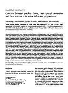
machine for GWCS at the machine to process the raw data for generating the customized data products. 3) Producing the WSDL and BPEL files: With the available service instances, their WSDL files, and the parameter mappings, a BPEL file is produced to express the concrete workflow according to the BPEL standard syntax. Meanwhile, a WSDL file is produced to describe the workflow. Both BPEL and WSDL files are necessary for the execution of the concrete workflow. D. BPEL-compliant Grid Workflow Engine Service A BPEL-compliant Grid workflow engine, named as GridBPELPower, is designed and implemented to execute the Grid service workflow in the Grid environment. The GridBPELPower is unique in the Grid computing world. It is the first BPEL engine that can be run in the Grid environment to process Grid services. It not only works as a Grid services to be invoked by other Grid services for execution of the Grid service workflow, but also be a Grid services container in which any other Grid services can be deployed and run. The GridBPELPower mainly consists of two components: 1) Grid services container: any Grid services can be deployed into GridBPELPower with its WSDL. Any qualified user can execute those deployed Grid services. Users can firstly learn about deployed Grid services through their WSDL, then, input parameters and specify input data (by URL) to run the Grid services for getting back the result data. 2) Grid services workflow executor: with the WSDL and BPEL files, any Grid services workflow can be deployed and run with the engine. In fact, any standard BPEL process with its WSDL can be deployed into the engine and can be executed. With all services discussed above, a geospatial abstract processing model can be instantiated into a BPEL-compliant Grid services workflow through the Instantiation Service. And the concrete workflow is executed by the BPELcompliant Grid Workflow Engine Service to provide users their requested data through the use of domain experts’ geospatial knowledge expressed in the model. Currently, only a few trained people posses such knowledge. As the result, the use of geospatial data is heavily limited by the availability of such professionals. This situation has significantly hampered the wide use of geospatial data for societal benefits. The approach of Virtual Geospatial Products is a perfect solution to this situation. V. SYSTEM ARCHITECTURE AND ITS IMPLEMENTATION Figure 1 is the system architecture for implementing the Virtual Geospatial Products in the Grid environment, which is based on the Globus technology with the Grid Security Infrastructure (GSI). A big Virtual Organization (VO) is established among the CSISS, NASA Ames Research Center
(ARC) and Lawrence Livermore National Laboratory (LLNL). The VO now consists of the GMU CSISS VO, the NASA ARC VO, and the LLNL Earth System Grid (ESG) VO, each of which has its own Certificate Authority (CA) issuing host, user and services certificates for qualified users in the big VO. We set the authorization and authentication up between any two VOs and any two machines in the big VO. Thus, any Grid services in the big VO can invoke or be invoked by other Grid services of this VO or any other authenticated Grid services from another authorized VO. So, the Instantiation Service and the Grid Workflow Engine Service can chain and execute any Grid services in the big VO [3] [11]. The system architecture enables Earth science experts and users to utilize Grid-managed distributed geospatial resources to produce more valuable geospatial products through the OGC standard interfaces without needs to either know or interface with underlying Grid technologies. It consists of three tiers. The first tier is the experts and general user tier that includes modeling interface for experts and data query and retrieval interface for experts and general users. The second tier is the OGC web service interface tier that mainly consists of OGC CS/W portal and WCS portal for providing OGC web service standards-compliant interface for any OGC users to transparently access Grid computing resources and Grid-based geospatial resources. The third tier is the Grid services tier that mainly includes Grid-enabled OGC geospatial services, extended Grid services, Grid geospatial services etc. The former two tiers provide the user-friendly and standards-compliant access interfaces for experts to
Modeling Interface
conveniently construct geoprocessing models and for general users to easily access geospatial resources. The last tier provides the foundation and component blocks for experts to easily and effectively express their specific knowledge and for general users to obtain the geospatial products they want through effective utilization of the foundation and experts’ knowledge in the Grid. Experts construct the abstract processing model through the modeling interface and register it into the system catalog through the GCS/W interface. General users submit their requests for geospatial products through the CS/W portal. A list of all qualified geospatial products, no matter real or virtual, is returned to the user interface with a simple metadata attached. Users can select from the list the geospatial products they want to retrieve. The request for data product retrieval is sent automatically to GVWCS, which forwards the request to iGSM for real data and the Instantiation service for virtual products. Instantiation service parses the abstract processing model to get a list of all ServiceTypes in the model. Then, it queries GCS/W and invokes ROS to obtain available best service instance and its WSDL description for every ServiceType. Based on these information, Instantiation service produces the BPEL and WSDL files and returns them to GVWCS. GVWCS sends both files to Grid Workflow Engine Service (GWES) – GridBPELPower. GWES executes the BPEL workflow to invoke various Grid service instance distributed in the Grid environment for producing the result data and returns the data URL to GVWCS. GVWCS returns the URL to user. User can get the requested data by the URL.
Retrieving & Acquiring Interface
WCS Portal CS/W Portal
GVWCS
GridCS/W
Virtual data request Real data request
Other Database
Legend: GVWCS: Grid-enabled Virtual Web Coverage Service iGSM: intelligent Grid Service Mediator ROS: Replica and Optimization Service GWES: Grid Workflow Engine Service GridWCS: Grid-enabled Web Coverage Service GridCS/W: Grid-enabled Catalog Service for Web GridWICS: Grid-enabled Web Image Classification Service GridWCTS: Grid-enabled Web Coordinate Transfer Service GRLS: Grid-enabled Replica Location Service IndexServie: Globus Monitoring and Discovery Service DTS: Data Transfer Service A,mes: NASA Ames Research Center LLNL: Lawrence Livermore National Laboratory
Instantiation Service GWES
iGSM Database for ServiceType, DataType ServiceInstance, DataInsance, Virtual geospatial products CSISS GridWCS
ROS GridWCS Ames GridWCS
LLNL GridWCS
Real geospatial data warehouse
Other Grid Services
GridWCTS GridWICS GRLS
IndexService
DTS
Globus Toolkit 4 0 1 with Grid Security Infrastructure
Fig. 1. System architecture for implementing the Virtual Geospatial Products in the Grid environment
VI. CONCLUSION A promising approach for implementing the virtual geospatial products in the Grid environment is discussed in this paper. The approach widely and repeatedly utilizes domain experts’ knowledge for Earth science research and applications. The approach is based on an abstract information model that can be used by domain experts to construct the abstract geoprocessing model. A BPELcompliant instantiation service is designed and implemented for instantiating the abstract geoprocessing model to a Grid service-oriented concrete workflow. Finally, a Grid workflow engine is devised to execute the concrete workflow in the Grid environment. The approach for virtual geospatial products discussed in this paper provides a mechanism to let not only domain experts expose their specific knowledge to benefit general users, but also general users transparently utilize the Grid resources. General users can benefit from the experts’ knowledge when they request the virtual geospatial products. This research project extends not only the application of Grid technologies to the Earth Science community, but also OGC standard Web services to the Grid environment. Two core Grid-enabled OGC Web services – GCS/W and GWCS are designed and implemented to play very important roles in registering, managing, retrieving, and serving abstract geoprocessing model, geospatial and non-geospatial Grid services, and geospatial data in the Grid environment. Other pure Grid services, such as, ROS, RLS, and DTS are proposed and designed to coordinate with other Grid services and provide optimized service instance and real geospatial data products. The orchestration of all geospatial and nongeospatial Grid services yields much better performance for the virtual geospatial product implementation. ACKNOWLEDGEMENT This research was supported by grants from NASA Earth Science Technology Office (ESTO) (NAG-13409, PI: Dr. Liping Di) and NASA REASoN program (NNG04GE61A, PI: Dr. Liping Di). REFERENCES [1] L. Di, “Geospatial Grids, geospatial modeling, and virtual geospatial products”, EOGEO’ 2004 (Earth Observation and GEOgraphic Information and
Communication Technologies), Jun. 23 – 25, 2004, London, UK. [2] I. Foster, C. Kesselman and S. Tuecke, “The Anatomy of the Grid – Enabling Scalable Virtual Organizations”, Intl. J. of High Performance Computing Applications, 15(3), 200-222, 2001. [3] A. Chen, L. Di, Y. Wei, and Y. Bai, “An optimized Gridbased, OGC standards-compliant collaborative software system for serving NASA geospatial data,” 2nd IEEE Systems and Software Week (SASW 2006), 30th Annual Software Engineering Workshop, Loyola College Graduate Center, April 25-27, 2006, Columbia, MD, USA. [4] L. Di, A. Chen, W. Yang and P. Zhao, “The Integration of Grid Technology with OGC Web Services (OWS) in NWGISS for NASA EOS Data”, HPDC12 & GGF8, Jun. 24 - 27, 2003, Seattle, USA. [5] L. Di, et al., 2006. “The Development of a Geospatial Data Grid by Integrating OGC Web Services with Globus-based Grid Technology.” Jounral of Concurrency. (Submitted). [6] Y. Wei, L. Di, B. Zhao, G. Liao, A. Chen, Y. Bai, Y. Liu, 2005. “The Design and Implementation of a Gridenabled Catalogue Service.” Proceedings of IGARSS 2005. July 25-29, Seoul, South Korea. 4p. (Invited). [7] L. Di, 2005. “Customizable Virtual Geospatial Products at Web/Grid Service Environment.” Proceedings of IGARSS 2005. July 25-29, Seoul, South Korea. 4p. (Invited). [8] L. Di, 2004. The Development of Geospatially-enabled Grid Technology for Earth Science Applications. Proceedings of NASA Earth Science Technology Conference 2004. June 22-24, 2004. Palo Alto, CA, USA. (8 pages. CD-ROM). [9] OGC, “OpenGIS Catalogue Service Specifications 2.0 – ISO19115/ISO19119 Application Profile for CSW2.0”, Open Geospatial Consortium Inc., Jun. 15, 2004. [10] I. Zaslavsky, C. Baru, K. Bhatia, A. Memon, et al. “Gridenabled Mediation Services for Geospatial Information”, Next Generation Geospatial Information – 2003, Oct. 19 - 21, 2003, Cambridge, Massachusetts, USA. [11] A. Chen, L. Di, Y. Wei, Y. Liu, Y. Bai, C. Hu and P. Mehrotra, “Grid Computing enabled geospatial catalogue web service”, American Society for Photogrammetry and Remote Sensing 2005, Mar. 7-11, 2005, Baltimore, USA.