vol. 160, no. 4
the american naturalist
october 2002
Notes and Comments Self-Organization of Vegetation in Arid Ecosystems
Max Rietkerk,1,2,* Maarten C. Boerlijst,3,† Frank van Langevelde,2,4,‡ Reinier HilleRisLambers,3,§ Johan van de Koppel,5,6,k Lalit Kumar,7,# Herbert H. T. Prins,2,** and Andre´ M. de Roos3,††
1. Department of Environmental Sciences, Utrecht University, P.O. Box 80115, 3508 TC Utrecht, The Netherlands; Erosion and Soil and Water Conservation Group, Wageningen University, Nieuwe Kanaal 11, 6709 PA Wageningen, The Netherlands; and Department of Plant Sciences, Wageningen University, Postbus 9101, 6700 HB Wageningen, The Netherlands; 2. Tropical Nature Conservation and Vertebrate Ecology Group, Wageningen University, Bornsesteeg 69, 6708 PD Wageningen, The Netherlands; 3. Section Population Biology, Institute for Biodiversity and Ecosystem Dynamics, University of Amsterdam, Kruislaan 320, 1098 SM Amsterdam, The Netherlands; 4. School of Mathematics, University of Natal, P/Bag X01, 3209 Scottsville, Pietermaritzburg, South Africa; 5. Spatial Ecology Department, Netherlands Institute of Ecology, P.O. Box 140, 4400 AC Yerseke, The Netherlands; 6. Department of Plant Biology, University of Groningen, P.O. Box 14, 9750 AA Haren, The Netherlands; 7. ITC International Institute of Aerospace Survey and Earth Sciences, Agriculture, Conservation and Environment Division, P.O. Box 6, 7500 AA, Enschede, The Netherlands Submitted January 15, 2002; Accepted March 26, 2002
Keywords: nonlinear dynamics, self-organization, spatial scale, Turing patterns, vegetation patterns.
Vegetation in arid regions of Africa, America, Australia, and Asia reveals remarkable patterns, such as spotted vegetation, labyrinths, gap patterns, and regular bands (Brom* Corresponding author; e-mail:
[email protected]. †
E-mail:
[email protected].
‡
E-mail:
[email protected].
§
E-mail:
[email protected].
k
E-mail:
[email protected].
#
E-mail:
[email protected].
** E-mail:
[email protected]. ††
E-mail:
[email protected].
Am. Nat. 2002. Vol. 160, pp. 524–530. 䉷 2002 by The University of Chicago. 0003-0147/2002/16004-0009$15.00. All rights reserved.
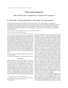
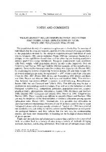
ley et al. 1997; Aguiar and Sala 1999; Klausmeier 1999; Leprun 1999; Couteron and Lejeune 2001; Von Hardenberg et al. 2001). Here, the term “arid” refers to environments characterized by an extended dry season, where yearly potential evaporation exceeds yearly rainfall, and where plant growth is limited by water availability. The two-phase mosaics of vegetation alternating with bare soil as observed in arid ecosystems differ in scale and shape, depending on slope gradient and rainfall. When slope gradient is !0.2% and mean annual rainfall ranges from 200 to 550 mm yr⫺1, observed vegetation patterns include spots with a diameter of 5–20 m, labyrinths with a vegetated band width of 10–50 m (fig. 1a), and gap patterns with bare spots in the vegetation with a diameter of 5–20 m (fig. 1b; Bromley et al. 1997; Aguiar and Sala 1999; Ludwig et al. 1999b; Valentin et al. 1999; Couteron and Lejeune 2001). On slopes steeper than 0.2% in arid regions, typical regular-banded vegetation patterns with a band width in the range of a few tens of meters are observed (Klausmeier 1999; Leprun 1999; Valentin et al. 1999; d’Herbes et al. 2001). Scientists are still searching for possible unifying mechanisms to explain this range of spatial patterns (Tongway and Ludwig 2001), and an important question of this research is whether this range is the result of preexisting environmental heterogeneity, the result of spatial selforganization, or both (Klausmeier 1999; Couteron and Lejeune 2001; HilleRisLambers et al. 2001; Von Hardenberg et al. 2001). Here, we contribute to the ongoing debate about vegetation pattern formation in arid ecosystems by presenting novel, spatially explicit model analyses and results, extending on the work of HilleRisLambers et al. (2001). Our results show that these different vegetation patterns observed in arid ecosystems might all be the result of spatial self-organization, caused by one single mechanism: water infiltrates faster into vegetated ground than into bare soil, leading to net displacement of surface water to vegetated patches. This model differs from earlier model results (Klausmeier 1999; Couteron and Lejeune 2001; HilleRisLambers et al. 2001; Von Hardenberg et al. 2001)
Notes and Comments 525 primarily in two ways: it is fully mechanistic, and it treats the lateral flow of water above and below the soil as separate, not independent, variables. Although the current model greatly simplifies the biophysics of arid systems, it can reproduce the whole range of distinctive vegetation patterns as observed in arid ecosystems, indicating that the proposed mechanism might be generally applicable. We further show that self-organized vegetation patterns can persist far into regions of high aridity, where plants would become extinct if homogeneously distributed, pointing to the importance of this mechanism for maintaining productivity of arid ecosystems (Noy-Meir 1973). Our analyses are based on the model first developed in HilleRisLambers et al. (2001), which we now briefly review. Vegetation patterning is generally linked to the mechanism by which plants increase surface-water infiltration into the soil, in combination with low annual rainfall conditions (Bromley et al. 1997; Klausmeier 1999; Leprun 1999; Ludwig et al. 1999a; HilleRisLambers et al. 2001). During rain showers, some rainwater will infiltrate into the soil, while the remainder will run off as surface water to other areas. With increasing plant density, the rate of infiltration of surface water into the soil will asymptotically approach a maximum (Rietkerk and van de Koppel 1997). Lateral flow of surface water is due to pressure differences measured by the slope of the thickness of the surface-water layer and can be described with a single diffusion term (Bear and Verruyt 1990; HilleRisLambers et al. 2001). Part of the infiltrated soil water subsequently evaporates or moves out of reach of plant roots by drainage and lateral subsurface flow due to capillary forces (Hills 1971; Lawrence Dingman 1994). Soil water uptake and plant growth are both assumed to be saturation functions of soil-water availability (de Wit 1958; Rietkerk et al. 1997). Plant dispersal, through seed or vegetative propagation, is approximated by a diffusion term (Okubo 1989; Cain 1990; HilleRisLambers et al. 2001). The model is a set of three partial differential equations describing the dynamics of three state variables: plant density (P ; g m⫺2), soil water (W; mm), and surface water (O; mm). The full model reads ⭸P W p c # g max # # P ⫺ d # P ⫹ Dp DP, ⭸t W ⫹ k1
where c (g mm⫺1 m⫺2) is the conversion of water uptake by plants to plant growth, gmax (mm g⫺1 m⫺2 d⫺1) is the maximum specific water uptake, k1 (mm) is a half-saturation constant of specific plant growth and water uptake, d (d⫺1) is the specific loss of plant density due to mortality, Dp (m2 d⫺1) is plant dispersal, a (d⫺1) is the maximum infiltration rate, k2 (g m⫺2) is the saturation constant of water infiltration, W0 (—) is the water infiltration rate in the absence of plants, rw (d⫺1) is the specific soil water loss due to evaporation and drainage, Dw (m2 d⫺1) is the diffusion coefficient for soil water, R (mm d⫺1) is rainfall, and Do (m2 d⫺1) is the diffusion coefficient for surface water (HilleRisLambers et al. 2001). Plausible parameters were obtained from the literature and were set as follows: c p 10, g max p 0.05, k 1 p 5, Dp p 0.1, a p 0.2, k 2 p 5, Wo p 0.2, rw p 0.2, Dw p 0.1, Do p 100, d ranges between 0 and 0.5, and R ranges between 0 and 3 (Hills 1971; Oborny and Cain 1997; Rietkerk et al. 1997; Klausmeier 1999; HilleRisLambers et al. 2001). A Laplacian operator was added for diffusion. We extended the original model in case of a slope by replacing the diffusion term DoDO with v dO/dx (eq. [1c]), in which v is the downhill
(1a)
⭸W P ⫹ k 2 # W0 W pa#O ⫺ g max # ⭸t P ⫹ k2 W ⫹ k1 # P ⫺ rw # W ⫹ Dw DW, ⭸O P ⫹ k 2 # W0 pR⫺a#O ⫹ Do DO, ⭸t P ⫹ k2
(1b) Figure 1: Aerial photographs from patterned vegetation in Niger (S.
(1c)
Prince, personal communication). Scale is 400 # 400 m. a, Labyrinths with spots; b, gap pattern.
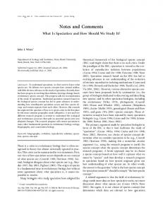
526 The American Naturalist flow that is set to 10 m d⫺1. The two-dimensional numerical simulations were forward Euler integrations of the finite-difference equations resulting from discretization of the diffusion operator. The spatial mesh consisted of a rectangular grid of 200 # 200 elements with reflecting boundary conditions. Simulations were started by introducing random plant peaks in 1% of the grid elements, which were all set in the plantless equilibrium of W p R/rw and O p R/(aW0). For the one-dimensional analysis, the bifurcation analysis program Content (Kuznetsov and Levitin 1997) was used. The typical spatial patterns on flat ground that are generated by our model are revealed in a two-dimensional domain representing 400 # 400 m for different amounts of rainfall. For R p 0.75 mm d⫺1, a spotted pattern is formed (fig. 2a), changing into labyrinths with spots for R p 1.0 (fig. 2b); a gap pattern is generated for R p 1.25 (fig. 2c). In the long run, both spots and gaps arrange themselves in a regular hexagonal pattern. On slopes, where surface water flows in one direction, the model generates regular vegetation bands, moving slowly uphill (fig. 2d). In a one-dimensional analysis, we now demonstrate how the various patterns are interlinked and how they originate from the spatially homogeneous equilibrium. We also illustrate that self-organized vegetation patterns can persist far into regions of high aridity, where plants would become extinct if homogeneously distributed. The model allows for a homogeneous equilibrium of plant density, soil water, and surface water. With decreasing rainfall, the homogeneous plant equilibrium decreases until plants become extinct for R ≤ 1.0 (fig. 3a). Close to this extinction threshold, the homogeneous plant equilibrium is unstable against small spatial perturbations. This is indicative of the principle of pattern formation as first outlined by Turing (Turing 1952): pattern formation can occur if an equilibrium is stable to spatially homogeneous perturbations but unstable to heterogeneous perturbations. From the Turing instability points unstable nonhomogeneous equilibria originate which link up to a stable nonhomogeneous equilibrium. This stable nonhomogeneous equilibrium, which is characterized by a single plant peak (fig. 3b), exists for a wide range of rainfall rates, and
Figure 2: Spatial patterns for different amounts of rainfall (R) after t p 3,000 d. Scale is 400 # 400 m. Plant mortality, d, is 0.25, with other parameters set at default values (see text). Plants are represented by dark green and bare soil by light brown. An animation of this model output is available on the on-line edition of The American Naturalist as an appendix. a, Spotted pattern, R p 0.75; b, labyrinths with spots, R p 1.0; c, gap pattern, R p 1.25; d, regular bands on slope (top on righthand side; periodic boundary conditions), R p 1.0.
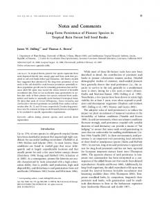
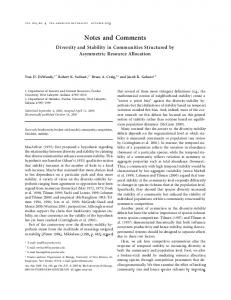
Notes and Comments 527 extends far into the region where homogeneous plant cover would go extinct (R ≤ 1.0). In general, the pattern formation leads to higher average plant productivity as compared to the homogeneous situation (cf. green and blue lines in fig. 3a). For a small rainfall range on the right-hand side of the Turing instability, the opposite is true. Here, a local gap in the plant cover is amplified (fig. 3c), leading to lower average plant productivity as compared with the homogeneous situation. The predicted Turing instability region and limit points of spatial patterns can be plotted as a function of rainfall and plant mortality (fig. 4). The rainfall range for which spatial patterns are predicted widens with increasing plant mortality. The predicted patterns in the two-dimensional domain correspond to these distinct regions. Toward the upper limit of spatial patterns, a spotted pattern is formed (fig. 2a). A profile through a single spot closely resembles figure 3b. Moving away from the upper limit of spatial patterns toward the Turing instability region, labyrinths with spots are formed (fig. 2b). Within the Turing instability region and moving toward its lower limit, this pattern gradually changes into labyrinths with gaps. Beyond the lower limit of Turing instability, a gap pattern is generated (fig. 2c). A profile through a single gap closely resembles figure 3c. We have demonstrated that the current model can adequately reproduce the whole range of distinctive vegetation patterns as observed in arid ecosystems, based on the net displacement of surface water to vegetated patches. In case of flat ground, the forms of the patterns generated by our model coincide with those found by Von Hardenberg et al. (2001); however, the scale of the patterns as well as the mechanism generating the patterns are different. The scale of the vegetation patterns generated by the current model is in the range of meters or a few tens of meters, while the scale of the patterns found by Von Hardenberg et al. (2001) is of the order of centimeters. This is due to the fact that our model takes the lateral flow of soil water as well as the lateral displacement of surface water into account, while Von Hardenberg et al. (2001) only consider transport of water in the soil, leading to
Figure 3: a, Bifurcation diagram based on a one-dimensional model for a spatial range of 50 m. Plant mortality, d, is 0.25, with other parameters as defaults (see text). Spatially homogeneous equilibria are in blue, nonhomogeneous equilibria are in red (showing maximum local plant densities). Solid lines denote stable equilibria, whereas dotted lines are unstable equilibria. The green line depicts the average plant density in the stable nonhomogeneous equilibrium. T1 (R p 1.001) and T2 (R p 1.259) are Turing instability points, and LP1 (R p 0.557) and LP2 (R p 1.312) are limit points. b, Profile of stable plant peak at R p 0.75. Plant density in red, surface water in blue, and soil water in green. c, Profile of stable plant gap at R p 1.25; lines as for b.
528 The American Naturalist
Figure 4: Region of spatial patterns as a function of rainfall and plant mortality. The points LP1, T1, T2 and LP2 from figure 3a are plotted as a function of R and d. Between LP1 and LP2, spatial pattern formation is possible, whereas between T1 and T2, the homogeneous equilibrium is unstable.
similar vegetation patterns but at a much finer spatial scale. This observation is of fundamental importance, reflecting spatial self-organization with respect to water resources at multiple scales, that is, at the scale of centimeters with respect to soil-water redistribution and at the scale of meters or a few tens of meters with respect to redistribution of surface water. Similar patterns on flat ground on the scale of a few tens of meters were also generated by a generic, single-variable vegetation model, based on the general premise that competitive interactions occur over a larger spatial scale than facilitative ones (Couteron and Lejeune 2001). Unlike this phenomenological model, our model explicitly incorporates the water dynamics thought to be responsible for vegetation pattern formation in arid ecosystems. Therefore, our results can be interpreted and evaluated in terms of parameters that have clear biophysical meanings. In case of a slope, our model results of patterns generated coincide with model results earlier reported (Klausmeier 1999) and strongly mimic observed patterns. Our model predictions elucidate how rainfall and plant mortality may affect the types of patterns that are generated (fig. 4). Plant mortality in arid vegetation is greatly affected by shifts in grazing intensity. Grazing by livestock is the principal land use in arid ecosystems. Increased grazing by domestic livestock in the African Sahel and New Mexico, for instance, has led to greater exposure of bare soil, increased soil compaction and erosion by surface water runoff, and asymmetrical distribution of water and
nutrients, creating patterned vegetation structures (Wood et al. 1987; Schlesinger et al. 1996; van de Koppel et al. 1997; Rietkerk et al. 2000). The finding that apparent homogeneous grazing (if the spatial heterogeneity of grazing is weak relative to the spatial heterogeneity of the vegetation) generates patterned vegetation structures appears typical of arid systems characterized by strong plant-soil feedbacks (Adler et al. 2001). Water infiltration in sandy soils is usually higher than in clayey and silty ones, particularly if the latter is crustforming. Thus, a higher water infiltration in the absence of plants (the parameter W0 in our model) corresponds to sandy soils, whereas low water infiltration corresponds to silty and clayey soils. The parameter range for which spatial patterns are predicted narrows for higher values of water infiltration (not shown), so we predict that patterns tend to develop more frequently on fine-textured than on sandy soils. The prevalence of social insect activities in arid ecosystems may also trigger more or less regular gap patterns in vegetation, that is, “termitaria-peppering” (Macfadyen 1950), through competitive interactions among colonies. However, we showed that this type of pattern (fig. 2c) may be the strict outcome of differential water availability. In arid systems, large interannual rainfall fluctuations are strongly associated with the El Nin˜o/Southern Oscillation phenomenon, triggering an increase in plant cover during wet years and a decrease or even desertification during droughts (Holmgren and Scheffer 2001; Holmgren et al. 2001). Vegetation structures may disintegrate and lose their natural water-harvesting function during reoccuring droughts, as the decrease of plant growth leads to overgrazing and vegetation collapse (Rietkerk and van de Koppel 1997; Rietkerk et al. 1997; van de Koppel et al. 2002). This in turn leads to export of water through overland flow or gully formation, resulting in desertification. Preserving the self-organized vegetation patterns during droughts and stimulating their recovery during wet years by adequate grazing management (Rietkerk et al. 1997; Holmgren and Scheffer 2001) might be crucial for maintaining productivity in arid ecosystems. Acknowledgments We thank P. Couteron, H. de Kroon, N. de Ridder, J. W. Hearne, P. Hiernaux, A. K. Skidmore, L. Stroosnijder, J. van Andel, and F. van den Bosch for their contribution and/or useful discussions and P. de Ruiter, J. Harvey, C. A. Klausmeier, J. Ludwig, S. Milton, I. M. M. S. Silva, and M. Stafford Smith for comments that significantly improved the manuscript. This study was supported by the Netherlands Foundation for the Advancement of Tropical Research, residing under the Netherlands Organization for
Notes and Comments 529 Scientific Research, and by a fellowship from the Royal Netherlands Academy of Arts and Sciences to M.C.B.
Literature Cited Adler, P. B., D. A. Raff, and W. K. Lauenroth. 2001. The effect of grazing on the spatial heterogeneity of vegetation. Oecologia (Berlin) 128:465–479. Aguiar, M. R., and O. E. Sala. 1999. Patch structure, dynamics and implications for the functioning of arid ecosystems. Trends in Ecology & Evolution 14:273–277. Bear, J., and A. Verruyt. 1990. Modeling groundwater flow and pollution; theory and applications of transport in porous media. D. Reidel, Dordrecht. Bromley, J., J. Brouwer, A. P. Barker, S. R. Gaze, and C. Valentin. 1997. The role of surface water distribution in an area of patterned vegetation in a semi-arid environment, south-west Niger. Journal of Hydrology 198: 1–29. Cain, M. L. 1990. Models of clonal growth in Solidago altissima. Journal of Ecology 78:27–46. Couteron, P., and O. Lejeune. 2001. Periodic spotted patterns in semi-arid vegetation explained by a propagation-inhibition model. Journal of Ecology 89:616–628. de Wit, C. T. 1958. Transpiration and crop yields. Verslagen van Landbouwkundige Onderzoekingen, The Hague. d’Herbes, J. M., C. Valentin, and D. J. Tongway. 2001. Banded vegetation patterns and related structures. Pages 1–19 in D. J. Tongway, C. Valentin, and J. Seghieri, eds. Banded vegetation patterning in arid and semiarid environments; ecological processes and consequences for management. Springer, Heidelberg. HilleRisLambers, R., M. Rietkerk, F. van den Bosch, H. H. T. Prins, and H. de Kroon. 2001. Vegetation pattern formation in semi-arid grazing systems. Ecology 82: 50–61. Hills, R. C. 1971. Lateral flow under cylinder infiltrometers: a graphical correction procedure. Journal of Hydrology 13:153–162. Holmgren, M., and M. Scheffer. 2001. El Nin˜o as a window of opportunity for the restoration of degraded arid ecosystems. Ecosystems 4:151–159. Holmgren, M., M. Scheffer, E. Ezcurra, J. R. Gutierrez, and G. M. J. Mohren. 2001. El Nin˜o effects on the dynamics of terrestrial ecosystems. Trends in Ecology & Evolution 16:89–94. Klausmeier, C. A. 1999. Regular and irregular patterns in semiarid vegetation. Science (Washington, D.C.) 284: 1826–1828. Kuznetsov, Y. A., and V. V. Levitin. 1997. CONTENT: a multiplatform environment for continuation and bifurcation analysis of dynamical systems. Centrum voor
Wiskunde en Informatica, Amsterdam. (Software under development.) Lawrence Dingman, S. 1994. Physical hydrology. PrenticeHall, Englewood Cliffs, N.J. Leprun, J. C. 1999. The influences of ecological factors on tiger bush and dotted bush patterns along a gradient from Mali to northern Burkina Faso. Catena 37:25–44. Ludwig, J. A., D. J. Tongway, R. W. Eager, R. J. Williams, and G. D. Cook. 1999a. Fine-scale vegetation patches decline in size and cover with increasing rainfall in Australian savannas. Landscape Ecology 14:557–566. Ludwig, J. A., D. J. Tongway, and S. G. Marsden. 1999b. Stripes, strands or strippels: modelling the influence of three landscape banding patterns on resource capture and productivity in semi-arid woodlands, Australia. Catena 37:257–273. Macfadyen, W. A. 1950. Vegetation patterns in the semidesert plains of Britisch Somaliland. Geographical Journal 116:199–210. Noy-Meir, I. 1973. Desert ecosystems: environment and producers. Annual Review of Ecology and Systematics 4:25–51. Oborny, B., and M. L. Cain. 1997. Models of spatial spread and foraging in clonal plants. Pages 155–183 in H. de Kroon and J. van Groenendael, eds. The ecology and evolution of clonal plants. Backhuys, Leiden. Okubo, A. 1989. Diffusion and ecological problems: mathematical models. Springer, New York. Rietkerk, M., and J. van de Koppel. 1997. Alternate stable states and threshold effects in semi-arid grazing systems. Oikos 79:69–76. Rietkerk, M., F. van den Bosch, and J. van de Koppel. 1997. Site-specific properties and irreversible vegetation changes in semi-arid grazing systems. Oikos 80: 241–252. Rietkerk, M., P. Ketner, J. Burger, B. Hoorens, and H. Olff. 2000. Multiscale soil and vegetation patchiness along a gradient of herbivore impact in a semi-arid grazing system in West Africa. Plant Ecology 148:207–224. Schlesinger, W. H., J. A. Raikes, A. E. Hartley, and A. F. Cross. 1996. On the spatial pattern of soil nutrients in desert ecosystems. Ecology 77:364–374. Tongway, D. J., and J. A. Ludwig. 2001. Theories on the origins, maintenance, dynamics and functioning of banded landscapes. Pages 20–31 in D. J. Tongway, C. Valentin, and J. Seghieri, eds. Banded vegetation patterning in arid and semiarid environments: ecological processes and consequences for management. Springer, Heidelberg. Turing, A. M. 1952. The chemical basis of morphogenesis. Philosophical Transactions of the Royal Society of London B, Biological Sciences 237:37–72. Valentin, C., J. M. d’Herbes, and J. Poesen. 1999. Soil and
530 The American Naturalist water components of banded vegetation patterns. Catena 37:1–24. van de Koppel, J., M. Rietkerk, and F. J. Weissing. 1997. Catastrophic vegetation shifts and soil degradation in terrestrial grazing systems. Trends in Ecology & Evolution 12:352–356. van de Koppel, J., M. Rietkerk, F. Langevelde, L. Kumar, C. A. Klausmeier, J. M. Fryxell, J. Hearne, et al. 2002. Spatial heterogeneity and irreversible vegetation change in semi-arid grazing systems. American Naturalist 159: 209–218.
Von Hardenberg, J., E. Meron, M. Shachak, and Y. Zarmi. 2001. Diversity of vegetation patterns and desertification. Physical Review Letters 87:19. Wood, J. C., M. K. Wood, and J. M. Tromble. 1987. Important factors influencing water infiltration and sediment production on arid lands in New Mexico. Journal of Arid Environments 12:111–118.
Associate Editor: Mark Westoby