development of a Task Orientated - Application of Spatial Information. Systems ... and custom controls, the HTML standard may be employed to develop a.
Transactions on Ecology and the Environment vol 10, © 1996 WIT Press, www.witpress.com, ISSN 1743-3541
Programming a Task Oriented Application of Spatial Information Systems Toolbox (TOASIST) - an example for the automated extraction of land cover and land use data from satellite imagery N. Rollings Department of Ecosystem Management, University of New
Abstract Spatial information technology has emerged as a major growth industry over the last 5 to 10 years. It is proffered that spatial information technology has much to offer the resource management community but is not widely utilised. It is suggested that current software is confusing to the lay-user, presenting a barrier to its operational use. Such persons invariably turn to system administrators who soon become swamped with data requests. The development of a Task Orientated - Application of Spatial Information Systems Toolbox (TO-ASIST) is offered as a possible solution to this problem. A TO-ASIST is an in-house developed piece of software dedicated to performing one task. Such systems may be developed using scripting languages offered by many vendors. Alternatively, the development of object oriented programming languages such as Visual Basic provide a simple environment which can tap into the rapidly expanding number of software custom controls. Major vendors are starting to release these custom controls providing direct access to their software functionality from within the design environment. Equally as important as demystifying spatial information technology, the TO-ASIST must also raise the technological skills of the layuser via on-line documentation and theory lessons. Again using Visual Basic and custom controls, the HTML standard may be employed to develop a series of on-line instructions that new users may access. The concept of a TOASIST is demonstrated through Land Use Modeller, a system designed to map land use from multi-temporal satellite imagery. An application of Land use Modeller over the Shire of Melton, Victoria, Australia, is presented.
Transactions on Ecology and the Environment vol 10, © 1996 WIT Press, www.witpress.com, ISSN 1743-3541
418
Computer Techniques in Environmental Studies
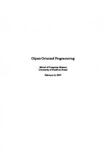
Introduction Spatial Information Technology (SIT) has much to offer the professional and lay-resource manager. SIT includes such technologies as remote sensing and geographic information systems. Despite over 20 years of research and development, there are still surprisingly few true operational uses of SIT and large sectors of the resource management community are not taking advantage of its functionality. Rollings* identified two major technical barriers to the wide-spread use of SIT by resource managers. First the complex nature of most SIT software is a deterrent for users to adopt the technology in an operational sense. Attempts have been made by vendors to overcome this problem For example, Earth Resource Mapping of Australia, developed a new concept of user interface while ESRI, arguably the largest GIS vendor in the world, have developed ARC/VIEW in order to make the technology more accessible. Despite these efforts SIT is still difficult to use for non-experts. Another barrier to the adoption of SIT is the lack of appropriately written technical material for new users to consult. Existing material appears to be overly technical and time consuming to digest. Users of Spatial Information Technology The implementation of a Spatial Information System (SIS) is driven largely from a technological perspective. Additionally, the impetus for such a system often comes from one individual, a section or a department within an organisation. Consequently, these systems are rarely designed with the whole organisation in mind and little attention is paid to end-users of the system. In resource management, the people who will make best use of the spatial database, the decision makers and their immediate staff, are not necessarily SIT literate and their computer skills may be low. Conversely, those who build and run the SIS are not directly involved in decision making, have very high computer literacy and are SIT experts. Naturally, there will be exceptions but to build a link between these two groups can be very difficult and is critical to the successful operation of the SIS, Figure 1 shows a common scenario where a SIS may not perform optimally due to poor access to the system and data by end-users. At the management level the system manager is in constant contact with other managers in order to promote the use of the SIS and gain feedback on management requirements. Similarly, there will be some interaction between the system administrator/technician and the end-users but the majority of queries should be conducted by the users themselves using tools that are
Transactions on Ecology and the Environment vol 10, © 1996 WIT Press, www.witpress.com, ISSN 1743-3541
Computer Techniques in Environmental Studies
419
developed by an applications developer. Unfortunately, end-users are rarely trained to an adequate standard to use the SIS software, even if it has undergone some customising. Often the tools are missing that enable endusers to access the GIS database and users are left to "fend" for themselves. In this situation, as depicted in figure 1, users will invariably request information from the system administrator/technician who soon becomes swamped with requests and is unable to perform their primary task (maintaining the GIS database) and cannot keep up with requests for data. Ultimately the system will collapse and cannot service the needs of its users effectively . A preferable situation is where a communication medium or similar is established for the end-users such that they can access the data they require directly. Under this scenario improved access to end-users can accomplished in one of three ways. 1. Improve technical skills of users such that they are familiar with and competent in the use of the SIS. While attractive to some, others will not want to (nor should they have to) become technically competent in SIS principles. 2. Employ project specialists or consultants to process data requests from end-users. This may be an attractive option for larger organisations who manage their activities on a project-by-project basis. A series of applications specialists may be employed on several projects at once to satisfy the requirements of the end-users. 3. Simplify the technology so that is easy enough for end-users to access it with minimal training. MANAGEMENT LEVEL OTHER MANAGERS
SYSTEM MANAGER SYSTEM LEVEL SYSTEM ADMINSTRATOR
II
OTHER USERS
Figure 1. A common scenario when end-users attempt to access a SIS with little success
Transactions on Ecology and the Environment vol 10, © 1996 WIT Press, www.witpress.com, ISSN 1743-3541
420
Computer Techniques in Environmental Studies
For those organisations who are not large enough to adopt solution 2, the answer lies in a combination of solutions 1 and 3. It is possible to simplify SIT to make it easier to access by end-users provided they have some degree of understanding and training in the use of SIT. In practice, a series of tools can be built to aid the end-user while an organisational, education programme can raise awareness of SIS and its capabilities. In figure 2 a series of tools have been built to allow end-users to access the GIS database directly thus freeing the system administrator to perform their essential role. Rollings and Condurso^ demonstrated the concept of a Task Orientated Image Processing System (TOIPS) that allowed land use information to be extracted from multi-temporal satellite imagery. This concept may be extended to SIS in general to produce the Task Orientated - Application of Spatial Information Systems Toolbox (TO- ASIST). Task Oriented Application of a Spatial Information Systems Toolbox : TO ASIST A TO-ASIST may be defined as a Customised software tool developed for a specific function using spatial information systems principles presented in an environment that promotes the understanding of SIT principles. Notice that a TO-ASIST is dedicated to one function. If a more complex TO-ASIST was developed then we are returning to a user interface menu, the very thing we are trying to avoid. The development of a TO-ASIST must be driven from the end-user rather that a SIT specialist attempting to predict what is needed. From concept to operational product, the following procedure will ensure that a useable TO-ASIST is developed. 1. An information need is established by end-users. It is the end users who are in the position to describe what they need, and ultimately shape the final form of the TO-ASIST. To do otherwise would run the risk of the technology manipulating the process for technological outcomes rather than the management process manipulating the technology to achieve good management and planning decisions. 2. The task is divided into sub-tasks and a flow diagram created to depict each task and where itfitsinto the overall structure of the TO-ASIST. 3. All tasks are undertaken in a pilot project by an SIT expert to test the soundness of the methodology. 4. Technological barriers are identified against each sub-task. 5. Solutions to the technological barriers are devised (if possible). 6. Key SIT concepts are identified next to each task and theory lessons and informative practical tips are written. 7. The structure of the TO-ASIST is developed.
Transactions on Ecology and the Environment vol 10, © 1996 WIT Press, www.witpress.com, ISSN 1743-3541
Computer Techniques in Environmental Studies
421
8. Based on the structure, an automated list of instructions are written for each step of each task. Theory lessons are linked to these steps. 9. Implementation options are considered. The system may be developed under the envelope of an existing system using a scripting language (eg. mapbasic in Mapinfo) or alternatively it may be developed using a lower level programming language such as Visual Basic. lO.The prototype system is developed and tested by the end-users. 11.Necessary modifications are made and the TO-ASIST is commissioned in the field. 12.The system is monitored for performance. MANAGEMENT LEVEL SYSTEM MANAGER
OTHER MANAGERS
f
1 1 | |
[SYSTEM LEVEL SYST EM ADMINSTRATOR
|
OTHER USERS -^
>
TOOLS GIS DATABASE Figure 2. An ideal scenario for end-users to access a SIS. Not all tasks will be suitable for customising into a TO-ASIST, particularly tasks that involved complex processing procedures with a high user-input based on experience. The use of expert systems may overcome this problem and is the focus of current research. Implementation of a TO-ASIST using a low level programming language versus a scripting language is a difficult decision. Tables 1 and 2 highlight some of the advantages and disadvantages of each method. It is apparent that for simple systems such as IDRISI, the low level programming language is a better option while on more complex systems, such as Arc/Info, a scripting language may be the preferred option. This may change as software is implemented under the Windows environment and SIT software functionality may be called via Dynamic Link Libraries and through custom controls.
Transactions on Ecology and the Environment vol 10, © 1996 WIT Press, www.witpress.com, ISSN 1743-3541
422
Computer Techniques in Environmental Studies Table 1 Development Using of Low Level Programming Language. Advantages
Disadvantages
1. Complete control over software 1. All functionality must be programmed from functionality, system can be fully basics "open" 2. Software development costs are high and 2. Distribution is easy, no need for need specialist staff expensive licenses in all offices 3. Many vendors use proprietary data structures which are not accessible to users.
Table 2 Development Using a macro or scripting Language. Advantages
Disadvantages
1. Full power of system is available 1. Functionality may be restricted to software with less programming required. functionality 2. Existing SIT experts can easily learn 2. Interfaces cari be clumsy the language 3. Licenses arcj often needed to run the software
The first signs of this are now evident as ESRI have announced a product called "Map Objects" which allow users to develop their own applications using Arc/Info tools via a custom control, designed for use with Visual Basic, C++, Delphi or a similar object oriented programming language. Development of a TO-ASIST : Land Use Modeller The need to map land use on a routine basis was established during a project concerned with water quality research Land cover and land use may be mapped via remote sensing but to make the application operational it was decided to develop a TO-ASIST to automate the land use extraction. Concept The purpose for which land is used is of interest both for planners and managers at all levels. Additionally, land use history can also be of interest when land use conflict issues arise, to model land degradation potential or when environmental degradation becomes evident. This is well illustrated by the current concern over toxic cyano-bacteria blooms in water storages and rivers whose catchments are dominated by agricultural land use. The extraction of land cover information over extended areas is feasible using satellite imagery. Current satellites can provide timely and repetitive information at a variety of spatial and temporal resolutions. While useful, the
Transactions on Ecology and the Environment vol 10, © 1996 WIT Press, www.witpress.com, ISSN 1743-3541
Computer Techniques in Environmental Studies
423
distribution of land cover is insufficient to provide reliable land use information. The ability to discriminate land use is dependent on resolving a time sequence of land cover types that correspond uniquely to a particular land use, eg a land parcel may be ploughed in month X but may be used for improved pasture, weed control or cropping. Only by observing that same paddock at a later date(s) can the land use be resolved. Hence a temporal database of land cover may be used to extract land use via the recognition of land cover patterns. Development The conceptual model as detailed by Rollings and Condurso^ required several technical barriers to be overcome. The basis of Land Use Modeller (LUM), as the TO-ASIST was termed, was the classification of a sequence of satellite images over a yearly growth cycle. By careful selection of several images, land use may be interpreted from a sequence of land cover images. To facilitate this, each image is classified into one of four simple cover types, forest, active growth, inactive growth and bare. A land cover vs land use calendar can then be constructed for a 12 month period. A sequence of images, local knowledge and common sense were used to construct a land use calendar depicting the sequence of land cover types for each land use. This calendar can then be used to select images that can uniquely resolve the desired land use classes. For example, native pasture, grazing land and crops may exhibit the active growth cover-type during winter. During the spring however, native pasture may appear as inactive growth and in summer much of the vegetation will be grazed and the area may resemble bare ground. Table 3 shows the land use calendar compiled for this study. Table3 Land use calendar as a function of land cover. Land use Improved Pasture Plough/fallow Winter Plough/crop Summer plough/crop Native/Poor Pasture Forest m- Inactive growth
J m mb mb bm mb f
F ml mb mb m mb f
b - Bare
M ml m mb b m f
A 1 m b b 1 f
M 1 m ml ml 1 f
J 1 m 1 1 1 f
J A 1 1 b b 1 1 1 1 1 m f f
1 -Active growth
S 1 b 1m 1m m f
O N D 1 1 ml m m m m m m b b b m m m f f f
f -Forest
Landsat MSS data was chosen for reasons of cost and the availability of archival data. Geometric integrity was assured by purchasing pre-rectified imagery from the data supplier. Once the data is received, LUM imports the data into the IDRISI data structure. The IDRISI structure was selected as it is
Transactions on Ecology and the Environment vol 10, © 1996 WIT Press, www.witpress.com, ISSN 1743-3541
424
Computer Techniques in Environmental Studies
a widely used system, the data structure is very simple and it is easy to manipulate IDRISIfilesusing in-house developed software. In order to make LUM easy to use it was decided that all image classification should be handled automatically with no user input. This required the use of an atmospheric compensation routine and a spectral library to classify the various cover types. Based on the image dates, entered during image import, LUM calibrates the images. Collection of spectral library was undertaken using the corrected imagery. Known cover types were identified in selected paddocks and their brightness values (B.V.) were recorded. This was undertaken over several years of imagery so an indication of variation could be quantified. For thefinalspectral library, averages were taken. These were later refined during an iterative classification of 8 images. In order to make LUM a stand-alone product, a standard minimum distance classification routine was written to apply the spectral library to the images. Classification files are stored in IDRISI format for further processing. To identify land use, the land cover patterns identified during the compilation of the land use calendar are applied. A new database layer of land use can now be extracted. This task is also automated and transparent to the user. The development of LUM made the process of extracting land use from satellite imagery possible by the lay person. In order to raise the level of knowledge of the lay operator it was decided to include a series of help files that guide the user through the various steps in LUM. Further to this, a series of theory lessons are included for those users who wish to investigate the theory behind LUM. Implementation All software development for LUM was undertaken using Visual Basic Professional Version 3.0 (VB) and a series of VB add-ons ( custom controls and DLL's developed by third party software specialists). This enabled full control over the code and its distribution. VB was selected because it uses the familiar BASIC programming language and graphical user interfaces may be built with little or no programming. This represents a considerable time saving. Coding was further simplified by using a third party coding assistant (VB Codemaster, Teltech, USA). VB Codemaster handles all code documentation, some dialogue box creation and all error handling. All image display was handled by a third party VB add-on (VisionTools, Evergreen Technologies, USA). This made image display much quicker than using VB code and will allow enhancement to be made to LUM in the future. All of the help files were created as Microsoft Help Files using a third party add-on (VB Helpwriter, Teltech, USA). VB Helpwriter reads a programmers code to generate the required help topics leaving the programmer to "fill in the
Transactions on Ecology and the Environment vol 10, © 1996 WIT Press, www.witpress.com, ISSN 1743-3541
Computer Techniques in Environmental Studies
425
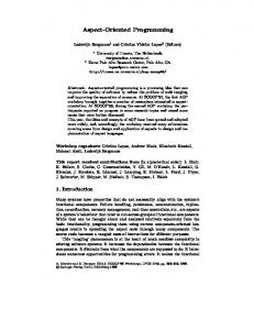
blanks". Microsoft helpfileswere kept to a minimum however in preference to hypertext markup language (HTML) documents. This allows the on-line help to be customised to users requirements at a future date. The additional theory files were developed in HTML within Microsoft Word 6.0 with a 3rd party add-on (Easyhelp, Eon Solution, UK). Easyhelp can generate Microsoft Help Files or HTMLfilesfrom the same document. The HTMLfilesare displayed from within LUM using another 3rd party add-on (Webster HTML OCX beta 914, Trafalmador, USA). The Webster custom control made it possible to write a HTML viewer and programatically change documents according to user input. Some video sequences are included as part of the theory lessons. These video sequences were captured using a video board (Videoblaster, Creative, Singapore). All video sequences were processed and edited on a PC (Adobe Capture and Premiere, Adobe, USA) and then passed to a dedicated video authoring package for hot-spot editing and compilation (MediaShop, Motion Works, USA). New Visual Basic custom controls are appearing on the market everyday. Major vendors of SIT are recognising that 3"* party application development using their custom controls to provide access to sophisticated SIT processing is the way to proliferation of their technology without the need to make systems completely "open". As more of these products become available, the development of a TO-ASIST using programming languages such as Visual Basic will become more practical and attractive. Application of a TO-ASIST : Land Use Modeller The area selected for this study was the Shire of Melton situated 40km West of Melbourne. This area was chosen due to the variation in land use including cereal cropping, grazing of livestock, thoroughbred horse breeding, urban expansion and conservation. In order to test LUM under a variety of conditions, images were selected from years where diverse weather conditions prevailed. Figure 3a shows a Landsat MSS image for October 1987 while figure 3b shows the corresponding classification using LUM. Figure 3c shows one of thefinalland use image as determined by LUM based on 2 Landsat MSS images for 1987. Discussion and Conclusion Spatial information technology has much to offer the resource management community. Many agencies however are not benefiting from this technology. One reason for this is a technological barrier between managers who need information and the complexity of the systems that can provide it. Some vendors have attempted to address this problem by writing generic "front-
Transactions on Ecology and the Environment vol 10, © 1996 WIT Press, www.witpress.com, ISSN 1743-3541
426
Computer Techniques in Environmental Studies
ends" or user interfaces to their products. Unfortunately, these products often fall short of their original objectives and the software is still daunting to some people. The development of a series of Task Orientated - Application of Spatial Information Systems Toolboxes may be a possible solution. A TOASIST may bring the technology to level where lay-users may access it with minimal training. A critical part of a TO-ASIST is comprehensive on-line documentation and "theory lessons" designed to raise the awareness of the lay-user without necessarily expecting them to become SIT experts. Visual Basic and the many 3"* party add-on modules available provide an easy to use environment for development of a TO-ASIST. The development of such a system requires an extensive knowledge of SIT in order to overcome the technical problems that will inevitably be encountered.
Figure 3a Landsat Image 3b 3c
b Land Cover
c Land Use
Dark Grey - Active Growth Black - Bare Light. Grey - Inactive Growth White - Forest White - Forest Light Grey - Marginal Pasture Black - Winter Crops Medium Grey - Summer Crops Dark Grey - Fallow
References 1 Rollings, N.M. Developing a Task Oriented Application of Spatial Information Systems Toolbox (TO-ASIST): Improving Access to Spatial Information Technology for Natural Resources Management. Unpublished PhD Thesis, in prep. 2 Rollings, N.M. and Condurso, C. Automated Land cover and Land use History Mapping from Satellite Imagery. Proceeding ofAURISA 94, Sydney, 1994.