IEEE TRANSACTIONS ON KNOWLEDGE AND DATA ENGINEERING
1
Skyline Processing on Distributed Vertical Decompositions George Trimponias, Ilaria Bartolini, Dimitris Papadias, Yin Yang Abstract—We assume a dataset that is vertically decomposed among several servers, and a client that wishes to compute the skyline by obtaining the minimum number of points. Existing solutions for this problem are restricted to the case where each server maintains exactly one dimension. This paper proposes a general solution for vertical decompositions of arbitrary dimensionality. We first investigate some interesting problem characteristics regarding the pruning power of points. Then, we introduce VPS (vertical partition skyline), an algorithmic framework that includes two steps. Phase 1 searches for an anchor point Panc that dominates, and hence eliminates, a large number of records. Starting with Panc, Phase 2 constructs incrementally a pruning area using an interesting union-intersection property of dominance regions. Servers do not transmit points that fall within the pruning area in their local subspace. Our experiments confirm the effectiveness of the proposed methods under various settings. Keywords—Distributed Skyline, Vertical Partitioning, Query Processing.
—————————— ——————————
1 INTRODUCTION
G
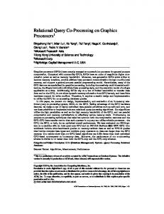
iven a data set DS of d-dimensional records/points, a record P ∈ DS dominates another Q ∈ DS, if P is no worse than Q on all d attributes/dimensions, and it is better than Q on at least one dimension. The skyline SKY ⊆ DS consists of all points that are not dominated. In this paper, we assume that the dataset is vertically distributed among m servers, so that a server Ni stores a subset Di of the dimensions and the ID of each record. For every two servers Ni and Nj (1≤i≠j≤m), Di∩Dj = ∅, i.e., the servers do not have common attributes except for the record ID. As a real-world example, consider that a mobile client wishes to compute the skyline over a restaurant dataset based on the following criteria: quality, value, proximity to cinemas, and distance from the current location. The former two attributes are provided by a restaurant rating service, whereas the rest are obtained from an on-line map server. Similarly in e-commerce applications, product prices may be provided by sites that find the lowest price (e.g., pricegrabber.com), while technical characteristics reside in specialized libraries (e.g., cnet). Fig. 1 shows an instance with two servers N1, N2, and 8 points A-H. N1 (resp. N2) maintains the subspace D1 = {d1, d2} (resp. D2 = {d3, d4}). Without loss of generality, throughout our presentation we consider that smaller values are preferred on all dimensions. The local skyline ————————————————
• G. Trimponias and D. Papadias are with the Dept. of Computer Science and Engineering, Hong Kong University of Science and Technology. E-mail: {trimponias, dimitris}@cse.ust.hk • I. Bartolini is with the Department of Electronics, Computer Science and Systems, University of Bologna. E-mail:
[email protected] • Y. Yang is with the Advanced Digital Sciences Center, Singapore. E-mail:
[email protected]
SKY1 at N1 contains a single point B, which dominates all other records in D1 (Fig. 1a). Similarly, the local skyline SKY2 at N2 consists of B and E (Fig. 1b). The global skyline SKY over all dimensions comprises all points that appear in SKY1 or SKY2 (i.e., B, E), as well as additional records that are not dominated by a single point on all dimensions, i.e., SKY = {B, E, A, C}. For instance, A ∈ SKY since it is dominated by different records (e.g., B and E) in the two subspaces. On the other hand, F, G, H and D are not in SKY because they are dominated by a single point (A, C, C, B, respectively) on all dimensions. d2
d4
E
D B G
D
local skyline
A
B
H
F
local skyline
G
H
C
A
F
E
C
d1
d3
(a) SubspaceD1 at server N1. (b) Subspace D2 at Server N2. Fig. 1. Running example.
In our setting, we assume that there is no central server to materialize SKY. Moreover, the skyline may change when updates occur to one or more servers (e.g., some restaurant ratings are altered), and it may depend on the particular user (e.g., the distance between the restaurant and the client’s location). Hence, SKY must be computed on-demand. The skyline algorithm should minimize the points retrieved from each server because the communication overhead constitutes the dominant factor in battery consumption for mobile clients [7][17]. Moreover, more data increase the amount of computations required to process them.
Manuscript received: June 2011, revised October 2011. xxxx-xxxx/0x/$xx.00 © 200x IEEE
2
A naïve method would transmit all record coordinates (from every server), based on which the client could derive SKY using any centralized skyline algorithm (e.g., [4][5][9]). Clearly, this is very inefficient in terms of both communication and computation overhead. To alleviate this problem, we can take advantage of the points received so far to eliminate records that are guaranteed to be dominated globally. In our example, assume that the client has received point B; then, the transmission of D by N1 and N2 can be avoided, since D is dominated by B in both subspaces D1 and D2. However, F, G and H must still be sent to the client (although they are not in SKY) because they are dominated by B in only one of the subspaces (D1). A natural question is which of the received records to utilize (and how), in order to eliminate the maximum number of false hits (i.e., points such as F, G, H that are not in the global skyline). We propose VPS (short for vertical partition skyline), a general methodology that exploits some interesting skyline properties to maximize pruning in two steps. Phase 1 searches for an anchor point Panc, which has the potential to eliminate a large number of records. Phase 2 uses Panc, possibly in combination with other points encountered during Phase 1, to generate a pruning area for each server; records that fall within this area are excluded from skyline processing. The rest of the paper is organized as follows. Section 2 surveys related work. Section 3 investigates the problem characteristics. Section 4 describes and analyzes the proposed algorithmic framework. Section 5 experimentally confirms the effectiveness of VPS, and Section 6 concludes the paper.
2 RELATED WORK The skyline operator [4] has received considerable attention in the literature of centralized databases [3][5][10][11] and horizontal decompositions, where each server stores a subset of the records [6][13][14][15]. On the other hand, the only work on distributed skyline processing for vertically partitioned data is [2], which aims at minimizing the communication cost considering that the client retrieves m attribute values for a set of records DS from m servers. Specifically, each server Ni (1≤i≤m) (i) maintains the ID and exactly one dimension di of every record in DS, (ii) sorts all objects in ascending order of di at a preprocessing step, and (iii) allows both sorted access (i.e., get the next record with the lowest di), or random access (i.e., given a record ID, obtain di). Balke et al. [2] propose two solutions called basic distributed skyline (BDS) and improved distributed skyline (IDS). In BDS the client first retrieves attribute values from the servers in a round-robin manner, using sorted accesses, until it reaches an anchor point Panc at all servers.
TKDE, 2011-06-0336
Records not encountered in any of the servers are worse than Panc on every dimension, and therefore dominated by Panc. Thus, the skyline is computed using only the points discovered before Panc. Fig. 2a presents BDS on the dataset of Fig. 1, assuming that the four attributes are distributed over four servers and sorted in ascending order. Anchor point A is discovered at the 5th round-robin iteration at server N2 1 . At this time, the client stops the sorted accesses, obtains (using random accesses) the remaining dimensions of all records encountered before A in some server, and computes SKY = {B, E, A, C}. In Fig. 2a, the gray cells (resp. circles) denote sorted (resp. random) accesses. Note that there are no circles for point F, because it is found after A in both N2 and N3, and therefore it is dominated by A, independent of its unseen dimensions. Thus, the transmission of the coordinates of F is avoided for servers N2 and N3. N1 B A E D F C G H
N1 N2 N3 N2 N3 N4 B B B B E B C A E C A E H E D H D F D A G C A G A F C A C H F C G F G G D G F D B F E H H E H D (a) BDS (b) IDS Fig. 2. Examples of BDS and IDS.
N4 E A F C H G B D
As opposed to BDS, which performs round-robin sorted accesses, IDS guides the search towards more promising servers (i.e., where an anchor point is likely to be found early) by interleaving sorted and random accesses. Specifically, whenever an object P is first visited using sorted access at a server Ni, the client asks each remaining server Nj (i≠j) for the attribute value P.dj through a random access. Then, the client estimates the number of additional sorted accesses needed for all servers to reach P, from their respective current positions. Note that this number is continuously updated by taking into account the current positions in all lists, in order to properly reflect the remaining sorted accesses. If the anchor point has not been set, or P needs fewer sorted accesses than the current Panc, then P becomes the new anchor. Servers that have not already found Panc perform sorted accesses in a round-robin fashion. As soon as all servers reach Panc through sorted accesses, the client computes the skyline. In the example of Fig. 2b, at the first iteration, server N1 retrieves point B with a sorted access. Then, N2-N4 perform random accesses to obtain the attribute values of B, as well as calculate the number of sorted accesses to reach B, which are 1 (for N2), 1 (for N3) and 7 (for N4). The
1 In fact, BDS would continue to the next point F, if it has the same coordinate as A on d2; for simplicity of exposition, we assume that all coordinates are different.
TRIMPONIAS ET AL.: SKYLINE PROCESSING ON DISTRIBUTED VERTICAL DECOMPOSITIONS
total number of sorted accesses needed for B is 9. Since the anchor has not been set, B becomes the current anchor. The next two servers N2 and N3 also encounter B with their respective sorted accesses. As B has already been encountered, no further operation is required. Then, N4 retrieves E; N1-N3 send to the client the attribute values of E, as well as the number of sorted accesses to reach it. Since E requires a total of 10 sorted accesses, B (with 6 additional accesses) remains the anchor. Given that N1-N3 have reached B, only N4 continues to perform sorted accesses, retrieving A, F, C, H, G, in this order, all of which necessitate more additional sorted accesses than B. Finally, when N4 reaches B, the client computes the skyline using the 7 points A-C, E-H it has encountered. Note that the transmission of the coordinates of D is avoided for all servers. Similar to BDS and IDS, we exploit a sorted order of points in each server and an anchor point Panc to prune the search space. However, whereas in 1D decompositions there is a single choice of ordering per server (i.e., on the corresponding coordinate), for arbitrary dimensionality there are numerous possible orders, with variable pruning power. Multidimensional sorting functions have been explored in the literature of sort-based algorithms for centralized skyline computation [3][5][9]. In that setting, a single server stores DS ordered on some monotone function fS. The goal is to compute the skyline by scanning the list and terminating as early as possible. While scanning the points in sorted order, the server maintains a stop point Pstop that satisfies an optimization criterion. Search terminates after discovering a point Q such that every point after Q is guaranteed to be dominated by Pstop. Bartolini et al. [3] prove that among all symmetric 2 sorting functions fS, the one leading to the earliest termination is minC, which orders points in increasing order of their minimum coordinate. Moreover, Pstop is the point with the minimum, maximum coordinate. As an example, assume that DS contains 2D points (1,4), (5,1), (2,3), (4,2), (4,4) ..., sorted on fS = minC. When (2,3) is encountered it becomes Pstop. The minimum coordinate (4) of point Q = (4,4) exceeds the maximum coordinate of Pstop = (2,3) and the search terminates because all subsequent points are dominated by Pstop. The skyline is computed using only the points up to Q = (4,4). As opposed to [3], which aims at minimizing the computational cost for a single server, in our setting we wish to minimize the transmission overhead for multiple servers. Furthermore, for vertical decompositions, there are multiple sorted lists (one per server), and Panc serves a different purpose
2 A function f is symmetric if it is invariant under any rearrangement of its variables. This implies that f does not privilege any attribute, which is natural for skyline computation.
compared to Pstop. Consequently, the optimality results of [3] are not applicable in our setting. In addition, our work is related to subspace skyline computation [8][12], which assumes that a single server stores the entire dataset, and returns the skyline in a given subspace of the domain, while minimizing the I/O and CPU costs. The main challenge in subspace skyline processing is that the dataset often has rather high dimensionality; consequently, algorithms using a single index over all dimensions are inefficient. Subsky [12] tackles this problem by first selecting a set of cluster centers, and then mapping each record in the dataset into a single value, which is its L∞-distance to its corresponding center. The server then indexes these values with a B-tree, and processes a subspace skyline query by scanning the leaves of the tree, until reaching certain termination criteria. This methodology is clearly inapplicable to our problem, since it requires a central server to compute the 1D mappings, index the results, and answer all incoming queries. The method of [8], called STA, partitions the data into low-dimensional subspaces, and indexes each such subspace with an individual R-tree. A subspace skyline is computed using the trees that cover the query subspace. To minimize node accesses, STA introduces pruning strategies, using a single point or multiple points. The single point strategy resembles IDS, and selects as anchor the nearest neighbor pNN of the “lower-left” corner with respect to L1-distance (i.e., the point that minimizes the sum of coordinates). Nodes dominated by pNN are eliminated. Regarding multi-point pruning, STA assigns to each subspace Di a set of pruning points DISi, so that index nodes that are dominated by any point in DISi are pruned. Let m be the total number of subspaces. The pruning sets satisfy the common point condition, which states that for any combination of m pruning points P1∈DIS1, P2∈DIS2, … Pm∈DISm, one of these points Pk must dominate all remaining m–1 points, in all subspaces except for its own Dk. To compute the pruning sets, STA examines the m subspaces in a round-robin fashion; each round retrieves a new point with minimum subspace L1distance to the query lower-left corner, and attempts to add it to the corresponding pruning set. Multi-point pruning in STA does not always eliminate more nodes than a single point [8]. Moreover, the CPU cost of verifying the common point condition increases exponentially with the number of subspaces, due to exhaustive verifications of all point combinations. In Section 4.3, we compare in detail the proposed techniques with previous work.
3 PROBLEM CHARACTERISTICS We consider distributed vertical decompositions of arbitrary dimensionality. A client wishes to compute the global skyline SKY by retrieving the minimum number of points from the servers. Since all points in SKY must be transmitted to the client anyway, our goal is to minimize the transmission of false hits, i.e., points received by the
3
4
TKDE, 2011-06-0336
client that do not belong to SKY. These records incur unnecessary communication cost and burden the skyline computation overhead. Section 3.1 defines the decomposition lattice, which represents all possible partitions. Section 3.2 describes pruning with a single point. Section 3.3 utilizes multiple points to further reduce the search space. Table 1 illustrates common symbols used in the rest of the paper. For ease of presentation, we consider that smaller values are preferable on every dimension, but the proposed methods can be used for every combination of minimization and maximization of attribute values on different dimensions. TABLE1 FREQUENT SYMBOLS Symbol m DS, |DS| D SKY Ni Di, |Di| PPJ VS PS IS P.Di PA.Di
Meaning Number of servers Dataset and its cardinality Global space Set of global skyline points The i-th server Subspace at server Ni and its dimensionality Set of pruned points for decomposition J Set of visited points transmitted at phase 1 Set of pruning points Set of incomparable points transmitted at phase 2 Projection of point P in subspace Di Projection of pruning area PA in subspace Di
3.1 Decomposition Lattice We first investigate the possible vertical decompositions and their relationships. Note that in our problem, the decomposition is already given; thus, the discussion regards the link between different settings. Specifically, we use the term Jsingle = ({d1, ...,d|D|}) to denote the special case, where a single server maintains all attributes (i.e., the setting of [3]). On the other side of the spectrum, the special decomposition Jfull = ({d1}, ...,{d|D|}) corresponds to full partitioning, where each server maintains exactly one attribute (i.e., the setting of [2]). In general, we write J = (D1, …,Dm) to denote the decomposition J of the global space D into m servers, where each server Ni (1≤i≤m) maintains the ID and a set Di of attributes for every record in DS. A decomposition J′ = (D1′, …,Dm′) of D into m′ servers (m