Revista Brasileira de Zootecnia © 2011 Sociedade Brasileira de Zootecnia ISSN 1806-9290 www.sbz.org.br
R. Bras. Zootec., v.40, n.10, p.2111-2120, 2011
Spatial variability of forage yield and soil physical attributes of a Brachiaria decumbens pasture in the Brazilian Cerrado Cristiano Magalhães Pariz 1, Morel de Passos e Carvalho1, Carlos Alessandro Chioderoli1, Fernando Takayuki Nakayama1, Marcelo Andreotti1, Rafael Montanari 1 1
Universidade Estadual Paulista “Júlio de Mesquita Filho”, Faculdade de Engenharia, Caixa Postal 31, 15385-000, Ilha Solteira, SP, Brasil.
ABSTRACT - The objective of this study was to analyze variability, linear and spatial correlations of forage dry mass yield (FDM) and dry matter percentage (DM%) of Brachiaria decumbens with the bulk density (BD), gravimetric (GM) and volumetric (VM) moisture, mechanical resistance to penetration (RP) and organic matter content (OM), at depths 1 (0-0.10 m) and 2 (0.10-0.20 m), in a Red Latosol (Oxisol), in order to select an indicator of soil physical quality and identify possible causes of pasture degradation. The geostatistical grid was installed to collect soil and plant data, with 121 sampling points, over an area of 2.56 ha. The linear correlation between FDM × DM% and FDM × BD2 was low, but highly significant. Spatial correlations varied inversely and positively, respectively. Except for DM% and BD, at both depths, the other attributes showed average to high variability, indicating a heterogeneous environment. Thus, geostatistics emerges as an important tool in understanding the interactions in pasture ecosystems, in order to minimize possible causes of degradation and indicate better alternatives for soil-plant-animal management. The decrease in FDM and increased BD1 are indicators of physical degradation (compaction) of Red Latosol (Oxisol), particularly in the places with the highest concentration of animals and excessive trampling, in Cerrado conditions, in the municipality of Selvíria, Mato Grosso do Sul State, Brazil. Key Words: bulk density, geostatistics, gravimetric and volumetric moisture, mechanical resistance to penetration, organic matter
Introduction The importance of pastures in cattle production in Brazil is related, among other factors, to its low production cost (Santos et al., 2009). Nevertheless, the recovery of degraded areas by using adequate management techniques – which depend on a better understanding of the involved mechanisms and the limits for sustainable use – is one of the paths to promoting increased beef production (Páscoa & Costa, 2007). The loads or mechanical pressures exerted by cattle trampling on the ground, particularly on bare soil, can lead to medium and long-term changes in the physical properties of that soil, usually resulting in superficial compaction, characterized mainly by increased bulk density (Bertol et al., 2006). Therefore, bulk density is important in agricultural studies due to its close relationship to water and oxygen storage and movement. It can also indicate possible compaction (Kiehl, 1979; Reichert et al., 2009). High mechanical resistance of soil to penetration
Received October 30, 2009 and accepted February 15, 2011. Corresponding author:
[email protected]
can limit root elongation and endanger root growth, and consequently plant development (Stolf, 1991; Reichert et al., 2009). Thus, characterizing spatial variability of agricultural soil, combined with other statistical decision-making techniques, can contribute to more cost-effective and environmentally sustainable cattle raising. In this context, kriging is a geostatistical method that generates maps of a given attribute for non-sampled soil in unobserved locations (Páscoa & Costa, 2007). The use of this method aims to detail the spatial variability of the soil’s physical and chemical attributes, as well as crop yield (Lima et al., 2007). Thereupon, the objective of the study was to analyze the viability of plant attributes (forage dry matter yield and relative dry matter) and soil attributes (bulk density, gravimetric moisture, volumetric moisture, mechanical resistance to penetration and organic matter), and define the linear and spatial correlations between plant attributes in order to establish a soil physical quality indicator that can reveal the possible causes of degradation of Brachiaria decumbens pastures at the study location.
2112
Pariz et al.
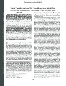
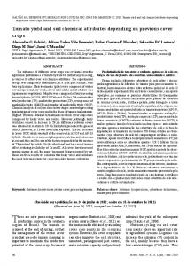
Material and Methods The experiment was carried out in 2008 at Fazenda de Ensino, Pesquisa e Extensão (FEPE), belonging to the Faculdade de Engenharia, Campus of Ilha Solteira (FE/ Unesp), Animal Production area, located in the municipality of Selvíria, state of Mato Grosso do Sul (latitude 20o22' 31"S and longitude 51o25'15"W), with average precipitation of 1.370 mm and average annual temperature of 24.1 o C. Climate type is Aw according to the Köppen classification, characterized as tropical humid, with rainy summers and dry winters (Figure 1). The soil in the area is a typical medium-texture Red Latosol (Oxisol) A moderate, hypodystrophic, alic, caulinitic, hypoferric, very deep, moderately acid, according to the Embrapa (2006) classification, with 410 g/kg of sand, 70 g/kg of silt and 520 g/kg of clay at 0-0.20 m of depth. The initial chemical attributes of the soil, assessed respectively at the depths of 0.0-0.10 and 0.10-0.20 m, were: pH (CaCl2) = 4.9 and 4.7; H+Al = 26 and 22 mmolc/dm3; P (resin) = 10 and 5 mg/dm3; K+ = 0.6 and 0.1; Ca2+ = 9 and 7; Mg2+ = 4 and 3 mmolc/dm3; and V = 34 and 31%. The Brachiaria decumbens pasture was implemented 33 years earlier (1978), and has been managed under continuous stocking (mean stocking rate of 1.5 UA in that period) for Guzerá cattle raising, receiving liming and fertilization during implementation and rehabilitation 23 years earlier (1988). It is currently in a stage of moderate degradation, with losses in productivity and quality, broadleaf weeds and soil compaction. At the time of data collection (March 29, 2008), the pasture had been deferred since February 1, 2008. The directions of the Cartesian axes for the experimental geostatistical grid were defined in an area located at the center of the pasture under study. Thus, the x-axis was set flat, whereas the y-axis was on a slope. Grid consisted of a total of 121 sampling points, distributed over an area of 2.56 ha (160 × 160 m), with average slope of 0.025 m/m.
Sampling points were spaced 20 m apart in the large grid and in the refined grid, with three swaths at the center of the grid (7.5, 5.0 and 7.5 m, respectively), horizontally and vertically. The refined grid was set up in order to detect ranges of spatial dependence for spacings smaller than those of the large grid (Figure 2). The soil attributes obtained around each sampling point were: bulk density (BD), gravimetric moisture (GM), volumetric moisture (VM), mechanical resistance to penetration (RP) and organic matter (OM) level, collected at depths of 0.0-0.10 and 0.10-0.20 m, and identified according to collection depth: a) 0-0.10 m: BD1, GM1, VM1, RP1 and OM1; b) 0.10-0.20 m: BD2, GM2, VM2, RP2 and OM2. The methodology employed to determine soil physical attributes was that given by Embrapa (1997). The samples used to determine gravimetric moisture were removed directly from the pits dug to determine bulk density, using the volumetric ring method. Mechanical resistance to penetration was obtained using an impact penetrometer (model Planalsucar/IAA/Stolf), calculated using the expression given by Stolf (1991): RP = {5.581 + 6.891 × [N / (P – A) × 10]} × 0.0981, in which: RP = soil mechanical resistance to penetration (MPa); N = number of impacts made with the penetrometer hammer to obtain the reading; and A and P = readings before (A) and after (P) the impacts (cm). Volumetric moisture (VM) was calculated according to the following expression: VM = GM × BD in which: VM = volumetric moisture (m3/m3); GM = gravimetric moisture (kg/kg); and BD = bulk density (kg/dm 3).
Rainfall Maximum Tº Minimum Tº Average Tº
Figure 1 - Rainfall and maximum, minimum and average temperatures for the experimental period.
Figure 2 - Scheme of the experimental grid placed on the pasture, representing the 121 sampling points and their respective spacing. R. Bras. Zootec., v.40, n.10, p.2111-2120, 2011
Spatial variability of forage yield and soil physical attributes of a Brachiaria decumbens pasture in the Brazilian Cerrado
The plant attribute collected in the field was the green matter yield of Brachiaria decumbens forage, in the blossoming stage, transformed into forage dry matter (FDM) yield through oven drying at 65oC until reaching constant mass. The useful area for collection of this attribute was 1 m2, assessed with the aid of a metal square placed at the center of the sampling point, and cutting height was 0.15 m. Results were extrapolated to kg/ha. The percentage of dry matter expressed as relative dry matter (rDM) was determined as well. The traditional descriptive analysis was carried out for each attribute studied. To test the hypothesis of normality, or lognormality, the Shapiro-Wilk test (1965) was carried out at 1% significance. The correlation matrix was set up to perform the simple linear correlations for the combinations, two by two, between the attributes studied. Geostatistical analysis was performed using Gamma Design Software 7.0 (GS+, 2004). The semivariogram models were fitted by selecting the lowest value of the sum of squared residuals (SSR) and the decision on the model was made through cross validation analysis. In cases of undefined stationarity of a given attribute, trends were removed from the data by using the polynomial regression technique. Hence, backtransformed attributes were preceded by the # symbol. Spatial dependence analysis (SDA) was performed according to the following expression: SDE = [C / (C + Co)] . 100, in which: SDE = spatial dependence evaluator; C = structural variance; and C + Co = threshold. So, the interpretation proposed for the SDE was the following: SDE ≤ 25% indicates weak spatial variable dependence; 25% < SDA ≤ 75% indicates moderate spatial variable dependence; and SDA > 75% indicates strong spatial variable dependence (GS+, 2004; Lima et al., 2007). Cross validation was used to evaluate alternative simple semivariogram models, for kriging modeling. In that process, each point within the spatial domain is removed individually, with its value estimated as if it did not exist. Thus, it is possible to construct a graph with estimated values versus those observed for all points. The correlation coefficient (r) between these values reflects the efficiency of the fit, given by the SSR technique, representing the linear regression equation in question. A perfect fit would have a regression coefficient equal to 1 and the best-fit line would coincide with the perfect model, with the linear coefficient equal to 0 and the angular coefficient equal to 1 (GS+, 2004). Thus, working to obtain the ideal number of neighbors, kriging maps were obtained through interpolation, for spatial dependence analysis between the attributes.
2113
Results and Discussion The variability of an attribute can be classified according to the magnitude of its coefficient of variation (CV) (Lima et al., 2007). Forage dry matter (FDM) yield and organic matter levels at 0-0.10 m (OM1) and 0.10-0.20 m (OM2) deep were highly variable, while relative dry matter (rDM), bulk density at 0-0.10 m (BD1) and 0.10-0.20 m (BD2) showed low variability (Table 1). The remaining physical attributes of the soil showed medium variability. In general, the coefficients of variation for attributes bulk density (BD) and mechanical resistance to penetration (RP) were in the same range as those described by Lima et al. (2009), Lima et al. (2007) and Colet et al. (2009), whereas the OM level was higher than those reported by Cavalcante et al. (2007) and Cavallini et al. (2010), obtained at the same location. The spatial variability of the soil – horizontal and/or vertical – results from the interaction of the factors and processes involved in its formation (Lima et al., 2007). Thus, the action exerted by animal grazing represents a decisive fact in increasing its spatial heterogeneity (Bertol et al., 2006; Páscoa & Costa, 2007). Therefore, both for bulk density (BD) and mechanical resistance to penetration (RP), combined with the fact of possible superficial soil compaction by animal trampling, the higher coefficients of variation found at the depth of 0-0.10 m attest that over the years grazing increased soil surface heterogeneity. In contrast, whenever a given variable has a normal distribution frequency, the measure of central tendency that best represents it is the mean. Thus, forage dry matter (FDM) yield showed a frequency distribution tending towards normal, with mean, maximum and minimum values of 2,184, 3,800 and 758 kg/ha, respectively (Table 1) – the latter being similar to the mean reported by Santos et al. (2007) in a dark Red Latosol with B. decumbens pasture 20 years after rehabilitation. Therefore, the pasture under study was likely degraded, given the lack of regrowth vigor and natural soil coverage capacity, as it had been deferred for approximately 60 days at the moment of harvest. Additionally, there was a high incidence of weeds (magnoliopsida; broadleaf), which is another indicator of degradation of this pasture. The frequency distribution was normal for bulk density at depth 2 (Table 1), similar to the data found by Lima et al. (2007), and tending towards normal for density at 1 m deep, whereas Lima et al. (2009),Cavallini et al. (2010), Martins et al. (2009) and Rosa Filho et al. (2009) observed normality in these attributes at both depths. The mean values for bulk density at depths 1 and 2 showed a marked difference (1.59 and 1.54 kg/dm 3 , respectively), while maximum values showed a greater interval (1.89 and 1.76 kg/dm3, R. Bras. Zootec., v.40, n.10, p.2111-2120, 2011
2114
Pariz et al.
Table 1 - Initial descriptive statistical analysis of forage dry matter yield for Brachiaria decumbens and attributes of a Red Latosol (Oxisol) Attribute 1
Mean
Median
Valor Minimum
Maximum
Standard deviation Plant attributes 671 2.82
CV (%)
Coefficient
Test Probability 2
Kurtosis
Asymmetry
Pr