Tetsuya Watanabe, Toshimitsu Yamaguchi, Ken Watanabe, Joji Akiyama. Faculty of Engineering/Graduate School of Science and Technology, University of ...
Tactile Map Automated Creation System to enhance the mobility of blind persons---its design concept and evaluation through experiment
Kazunori Minatani National Center for University Entrance Examination
Komaba 2-19-23, Meguro-ku, Tokyo,
153-8501 Japan Tetsuya Watanabe, Toshimitsu Yamaguchi, Ken Watanabe, Joji Akiyama Faculty of Engineering/Graduate School of Science and Technology, University of Niigata Ikarashi-2 8050, Nishi-ku, Niigata 950-2181 Japan Manabi MIYAGI Tsukuba University of Technology Kasuga 4-12-7, Tsukuba, Ibaraki, 305-0821 Japan Susumu OOUCHI National Institute of Special Needs Education Nobi 5-1-1, Yokosuka, Kanagawa, 239-0841 Japan
Abstract. The authors have developed a tactile map creation system (TMACS). It is intended to assist blind persons’ independent mobility. For this purpose, the system was designed to produce tactile maps, to be manipulated by the blind person and to support producing tactile maps of arbitrary locations of Japan. Through group interviews with blind persons, the authors collected information on what kind of strategies are useful for independ walk and what kind of objects can function as landmarks. TMACS is developed to make good use of these information. From the walking experiment, some assumptions which were made by the authors were confirmed. On the other hand, some unexpected or contradicted results were observed on the usefulness of landmarks and the cause of losing right routes.
Keyword: Blind person, Visually Impaired, Tactile Map, Independent Mobility, Orientation and Mobility
1 Introduction Tactile maps are helpful for blind person's mobility. The mobility of blind persons is considerably constrained by the fact that they can not easily understand geographical relationships, in particular, between the start and goal point. Certain degree of this constraint can be alleviated by using tactile maps. For independent mobility of blind persons, tactile maps should be generated by themselves because it is necessary for them to be able to examine their walking route anytime freely. Therefore, tactile map creating systems must be manipulated by blind persons without any assistance of sighted persons.
Up until now, no such system which fulfills above requirements exists in Japan. Geographical Survey Institute of Japan have developed a tactile map production system which works on Microsoft Windows platform. This system was named Shokuchizu Genkou Sakusei System[1]. With that system, arbitrary locations of Japan can be printed on capsule paper as tactile maps. But that system is totally based on a GUI application, a selection of objects to be included in tactile maps are operated with the mouse. Thus, a blind person who manipulates the computer using a screen reader can not use this system. Tactile Map Automated Production system (TMAP) is operated in the United States[2]. With this system, users can print out tactile maps of arbitrary locations in the USA with a braille (graphic) embosser. This system is designed for blind persons to be able to manipulate by themselves. Authors are influenced by the design concept of TMAP, however, this system supports only maps of the USA, so it can not produce tactile maps of locations in Japan. Using Web applications like Google Maps[3], sighted persons can consult the map anytime freely. However such applications can neither produce tactile maps nor be manipulated by the blind person. Therefore, the authors developed a system which satisfies above requirements and named it Tactile Map Automated Creation System (TMACS)[4].
product name
Table 1: Comparison of map creation systems Producible tactile Manipulatable by the maps? blind person?
Compatible in Japan?
Google Maps
no
no
yes
Shokuchizu Genkou Sakusei System
yes
no
yes
TMAP
Yes
Yes
no
TMACS
yes
yes
Yes
It should be noticed that the authors' TMACS is an attempt to assist blind persons’ mobility being based on researches about the readability of tactile graphics and the training of tactile observation. Tessa Wright et. al. reviewed such basic researches published between 1965 and 2008[5]. Then it was affirmed that certain achievement had been accomplished on educational matters of tactile recognition of the (young) blind person. Meanwhile, they claimed to effect on blind persons' practical mobility by achievements of such basic researches. Maps which are generated by TMACS are designed to be highly readable in accordance with prior researches and guidebooks which were compiled with academic insights[6][7][8]. Blind persons in Japan will expand their mobility if the authors' system is fully realized. In Japan, almost all roads in urban areas are paved with asphalt and have few bumps or holes. Guide blocks which can be recognized by the feet even through the soles of shoes are laid around and inside of public buildings and
stations. Therefore, it is probable that in Japan if the blind person can easily understand geographical relationships, he/she can walk comparatively safely without any assistance from sighted persons. TMACS is intended to furnish such geographical information which are necessary for blind persons’ independent mobility. Also TMACS is to be of benefit to blind persons who do not or can not walk out alone. By reading tactile maps generated by TMACS, they can understand routes which they will pass with a guide assistant. Having the knowledge on the route beforehand, they can consider the route on which are now walking. Then, they can acquire confidence on their orientation even when guided by other people. It is expected that a series of such experiences improves their ability of orientation and mobility. Originaly TMACS was developed to be utilized by Japanese blind persons. It was, however, designed to be applicable to any other regions than Japan. TMACS works on Apache 2.2.9 Web server[9] with Mapserver 4.10[10] on Linux (Fedora release 8) operating system[11]. Map data for TMACS is stored as GIS data of Mapserver. Therefore if GIS data of any country are accommodated, TMACS can serve as a tactile map production system for that country with the smallest effort.
2 Information and objects which should be or should not be included in a tactile route map Much information included in maps for sighted person must be omitted positively as the human ability of tactile recognition is considerably restricted compared with the visual recognition. Therefore information which is indicated on usual maps can not be fully included in tactile maps for blind persons. Plus, maps for sighted persons include objects which are only recognized visually (ex. signs hanged out on the roof, and colors of buildings). Intersections and alleyways should appear on a tactile map as exactly as possible, for they are essential to plan a route to the destination[12]. When blind persons plan a course to walk referring a tactile map, generally they count alleyways which are crossing the road they are walking along and design a plan such as "go northward on the slightly winding road passing five alleyways, then turn eastward at the intersection and go straight passing two alleyways". So intersections and alleyways are essential in a tactile map. When a blind person recognizes the circumstance of an area, some objects also play a particularly important role. While walking on the route, recognizing such objects allow blind persons to check whether or not his/her understanding of the present place is correct. At three workshops on tactile maps, authors conducted group interviews with blind persons as to what kind of objects were useful as blind person's landmarks while walking independently. The first
workshop on July 2008 was attended by 7 blind person, the second on February 2009 was 5, third on January 2010 was 8. Their answers can be summarized as follows. 1. Gas stations: Generally they locate at the corner of a block and two sides of a structure which adjacent to crossing roads are widely opened for customers' car entrance. They often smell of gasoline. So, blind persons can easily identify them via his/her auditory and olfactory senses. 2. Convenience stores: In Japan, in particular in urban areas, a man can find many shops called "convenience stores". They are comparatively small shops and are open around the clock. When their automatic door opens, unique sounds are often heard, such as an electric cash registers and background music with signage announcement. These stores usually sell cooked and ready-to-eat meals at the counter. So the stores smell of these foods, as well. These characteristic are recognized by acoustic or olfactory senses. 3. Fast food restaurants: They have similar characteristics to convenience stores. 4. Pinball saloons (Pachinko parlor): In Japan, a man can find a few pinball saloons in front of almost all urban railway stations. They are making enormous amount of noises; electric sound effects, jingles and announcements at full volume inside a hall. In some cases, their noises are stressful for a walking blind person by blocking environmental sounds, however they can be heard with no concentration, so they are functioning as auditory landmarks.
3 The design concept of the Tactile Map Automated Creation System Acoustic and olfactory landmarks should be placed on the tactile map for blind persons' independent walk. On the other hand, through interviews, it also became clear that the recognition of landmarks shows wide differences depending on occasions and from person to person. All landmarks are not recognized perfectly all the time. Landmarks which are used as cues for a blind person are different among individuals. Landmarks which are described above are not available in anytime, for instance shops do not make sounds or spread smells when they are closed. These facts should be taken into account in designing TMACS. Based on this understanding, the system has been developed so that its users can select landmarks arbitrarily. These insights should be considered to be applicable to any tactile map production system for blind persons which supports any region. Landmarks which function as acoustic or olfactory landmarks vary according to cultures. At the same time, it is immutable that objects and places with acoustic or olfactory characteristics function as landmarks for the blind person.
Thus, for the development of a tactile map production system for blind persons which supports arbitrary regions, it is important that available GIS data should not only contain many landmarks as posible but also subdivide them into categories as posible. In general, landmarks contained in GIS data for sighted persons are not categorized by acoustic or olfactory characteristics. Therefore, system developers must contrive a way to automatically select useful landmarks for blind persons out of general GIS data.
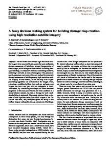
4 Experiments conducted for the evaluation of Tactile Map Automated Creation System To evaluate the effectiveness of tactile maps generated by TMACS in assisting blind persons' walk, the authors conducted a walking experiment. Procedure Blind participants were required to walk to the destination which is less than 1 km away from the starting point. Tactile maps generated by TMACS on the capsule paper were provided to the participants. The maps pointed out the starting point, the destination and landmarks which were considered to be useful for blind person's walking. The participants read the tactile maps and planned the route from the starting point to the destination. Areas at which experiments were carried out were selected from locations where participants have never visited before. So participants could not rely on their memory but had to utilize the tactile maps. goal legends legends
guide
direction
water
signal guide scale starting point Figure 1: The tactile map of Route 1 Experimental areas were selected out of Tokyo with the condition that the area has listed landmarks within its radius of 300 m around a station: more than ten signals, more than six convenience stores, more than four fast food restaurants and at least a gas station, a drug store and a pinball saloon. Authors could
not find areas which fully met above conditions. Then, most desirable ones were selected with consideration on convenience to carry out an experiment. Selected areas are shown below. Route 1: from Nishi-kasai station to Edogawa sports center (700m) (Figure 1) Route 2: from Monzennakachou station to Tomioka-Hachiman shrine (420m) Route 3: from Hacchoubori station to Tokyo Stock Exchange (700m) Two participants were requested to walk along these three routes. Indeed, it was carried out with only two participants. This experiment required of a participant a certain degree of ability of mobility. If he/she did not have such ability, participants would put themselves in danger. So, the authors selected participants very cautiously, and the number of participants were limited. The number of participants should be increased in the future. To ensure the security of participants, three assistants observed the environment; two both in front and behind of the participant distantly and another one following the participant closely to tell critical information on security---for example signals color---.
5 Results of the experiment and the conclusion Results of the experiment is shown below (Table 2and 3). Table 2: Time required for reading maps and walking routes (unit: minutes). Time for reading tactile map
Time for walking
participant A
participant B
participant A
participant B
route 1
11.25
12.78
17.83
21.42
route 2
7.33
7.32
16.50
11.25
route 3
6.75
7.28
17.38
18.93
Table3: Recognition rate of landmarks. participant A route 1 intersection (pass) intersection (turn) signal convenience store fast food restaurant gas station
3/4 1/1 3/4 0/2 0/1 0/0
route 2
route 3
6/7 1/2 0/0 0/1 0/0 1/1
10/10 2/2 4/4 0/2 0/1 1/1
participant B recognition rate 90 80 88 0 0 100
route 1
route 2
route 3
3/4 1/1 2/4 0/2 0/1 0/0
7/7 1/1 0/0 0/1 0/0 1/1
10/10 2/2 4/4 0/2 0/1 1/1
From the experimental results, the assumptions below were confirmed.
recognition rate 95 100 75 0 0 100
1. Tactile maps generated by the TMACS are useful in assisting blind persons' walk, planning a route toward the destination, and knowing the circumstances along the route. 2. The strategy of counting intersections and alleyways functions as a way to check his/her present location. 3. Gas stations can function as a landmark for blind persons. On the other hand, results below were unexpected or contradicted with the prior assumption. 1. Convenience stores and fast food restaurants did not function as landmarks for blind persons. 2. The parking area and the entrance of public garden were misidentified as alleyways. From these results, conclusions can be drawn below. 1. TMACS is useful in assisting blind persons' walk. 2. Some objects or places which have acoustic or olfactory characteristics do not work as landmarks in contradiction to some blind persons’ comments (e.g. convenience stores and fast food restaurants). 2. Blind persons often confuse open space such as parking areas and the entrances of public gardens with alleyways. It is expected that such spaces should be signified on the tactile map. 1. http://zgate.gsi.go.jp/shokuchizu/. 2. Joshua A. Miele and James R. Marston: Tactile Map Automated Production (TMAP): Project Update and Research Summary, CSUN, 2005 Proceedings, 2005. 3. Tetsuya Watanabe, Toshimitsu Yamaguchi, Kazunori Minatani, Susumu Oouchi, Manabi Miyagi, and Yasushi Iwashita, Development of a Tactile Map Production System Accessible to Blind Persons, IEICE technical report, 108(488), pp.13-18, 2009. 4. http://maps.google.com 5. Tessa Wright, Beth Haris, and Eric Sticken, A Best-Evidence Synthesis of Research on Orientation and Mobility Involving Tactile Maps and Models, JVIB Feb. 2010. 6. Yvonne Eriksson, Gunnar Jansson and Monica Strucel: Tactile maps - Guidelines for the production of maps for the visually impaired, The Swedish Library of Taling Books and Braille, 2003. 7. Yvonne Eriksson and Monica Strucel: A guide to the Production of tactile graphics on swellpaper, The Swedish Library of Taling Books and Braille, 1995. 8. Polly K. Edman, Tactile Graphics, AFB Press, 1992. 9. http://www.apache.org 10. http://mapserver.org/ 11. http://fedoraproject.org/ 12. Susumu Takamiya, and Shunichi Hamada, Information Used by Visually Impaired People While Walking, Transportation Research Record, 1636, pp.104-109, 1998.