Usability Engineering for Mobile Maps Rosemarijn Looije
Guido M. te Brake
Mark A. Neerincx
TNO Defence and Security P.O. Box 23, 3769 ZG Soesterberg, the Netherlands +31 (0)346 356 370
TNO Defence and Security P.O. Box 23, 3769 ZG Soesterberg, the Netherlands +31 (0)346 356 253
TNO Defence and Security P.O. Box 23, 3769 ZG Soesterberg, the Netherlands +31 (0)346 356 298
[email protected]
[email protected]
[email protected]
ABSTRACT
proximity of a house that should be checked).
Many applications for mobile devices make use of maps, but because interaction with these maps can be laborious the applications are often hard to use. Therefore, the usability of maps on mobile devices must be improved. In this paper we review the research that has been done to solve technical, environmental, and social challenges of mobile map use. We will discuss interaction, visualization, and adaptive user support for maps on mobile devices. We propose usability engineering as the method that should be used when developing maps for mobile applications.
This paper addresses usability issues of mobile maps. Due to the small size of the screen and the limited interaction possibilities use of mobile maps is often found strenuous by the users. Interaction with the map often distracts the user from the main task such as route planning or orientation, instead of assisting him or her. Furthermore a mobile device is used in more diverse conditions than desktop applications. The environment in which a mobile device is used can change all the time and the user can be sitting, standing, or walking, influencing the cognitive workload of the user.
Categories and Subject Descriptors H.1.2 [Information Systems]: User/Machine Systems – Human Factors. H.5.2 [Information Systems]: User Interfaces – User Centered Design, Theory and Methods, Interaction Styles, Screen Design, Evaluation Methodology. J.7 [Computer Applications]: Computers in Other Systems – Consumer Products.
General Terms Design, Human Factors, Theory.
Keywords Usability engineering, geospatial systems, mobile devices.
1. INTRODUCTION Many applications for mobile devices make use of maps, for example for route planning and navigation. Location-based services can be offered on mobile maps to provide appropriate information to a diverse range of users, such as tourists (is there a cheap hotel nearby), citizens of a city (where is a free parking place nearby), or policemen (a reminder that he/she is in the
Permission to make digital or hard copies of all or part of this work for personal or classroom use is granted without fee provided that copies are not made or distributed for profit or commercial advantage and that copies bear this notice and the full citation on the first page. To copy otherwise, or republish, to post on servers or to redistribute to lists, requires prior specific permission and/or a fee. Conference’04, Month 1–2, 2004, City, State, Country. Copyright 2004 ACM 1-58113-000-0/00/0004…$5.00.
Solutions are being developed, but most have not been thoroughly tested yet. Some experiments have been done to test the different solutions, but few were tested on mobile devices in outdoor environments. Current engineering methods focus strongly on system architecture, but little on context of use and user diversity, issues that are important for mobile applications. We will give an overview of design challenges and of proposed solutions for mobile devices. Next we propose that a usability engineering approach should be used when designing applications for mobile devices. Issues on usability engineering for mobile devices will be described, and two use cases taken from recent literature are presented to illustrate the advantages of usability engineering.
2. Challenges Mobile devices present a number of usability problems that can be divided into technical, environmental, and social challenges [11]. Technical challenges, such as battery life and network connectivity, are currently being addressed by industry and big improvements are made. Other technical challenges of mobile devices, such as limited screen sizes, have to be taken into account when designing applications for mobile devices. The environmental challenges are diverse, and include temperature, light conditions, noise, distraction, mobility of the user, cognitive and physiological constraints of the user, competition for attention of other tasks, and the need to manipulate objects other than the mobile device. These environmental challenges are inherent to mobile interaction. Normally when designing a product the environment in which it will be used is known. With mobile devices the user can not only use it in different environments, but the user can be sitting, walking, or standing when using the device. The usability is very much influenced by these different activity modes of the user and the ever changing environment.
determine which direction the device is moved and zooming is done by moving the phone in the direction of the camera image, while zooming out is done by moving the device closer to the user, and (4) panning by using speech commands such as, left/right/up/down
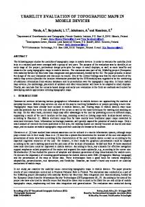
Figure 1 Hopping (figure from Irani, P., Gutwin, C., & Yang, X. D. (2006) ) The social challenges include privacy, acceptance and adoption issues, comfort, and personalization. When the technology proceeds and privacy can be better guaranteed, people are more comfortable and accepting towards mobile devices. Personalization can also enhance the comfort and acceptance of mobile devices. Personalization can be done by the user or can be done automatically. When a user interface adapts automatically to changing circumstances, it is called adaptive. Adaptive interfaces can decrease the number of social and environmental challenges. In this section we first present possible design solutions for technological challenges, after which we focus on applying adaptivity to tackle environmental and social challenges.
2.1 Technological challenges The usability of mobile maps depends heavily on the interaction with the map, the interaction with the mobile device, and the visualization of the information on the map. With the design of the interaction and the visualization of the information, technological challenges such as screen size, interaction limitations of the device (buttons, joystick, physically moving the phone, speech, or touch screen), and wireless connection speed have to be taken into account. For service/client enabled maps for example the connection speed is very important to make the zooming and panning smooth. A slow connection can be partially resolved by prediction of what the user likes to see in the future and retrieving this information beforehand and by animating the transitions between different images [20; 38] to keep the user spatially and situational aware. In the following section we give an overview of techniques and manners of interaction and visualization for mobile maps that can enhance the usability.
2.1.1 Panning On a mobile device there is not a lot of space to display maps; therefore it is useful to have the ability to pan. The interaction with the device is limited by its input possibilities; numpad, joystick, touch screen, and if the presence of a camera. Several panning methods exist for devices without touch screen: (1) panning with the buttons of the device, the numbered buttons or the directional pad, (2) panning with the joystick (if the device has one), (3) panning by physically moving the phone using the camera [15; 15; 23]. The image of the camera is used to
When the device has a touch-screen, additional options are: (1) move the stylus over the screen so the screen or the background is dragged in the direction of the stylus, (2) centralize the point on the screen that is touched by the stylus, (3) radial scroll [35], this is a method wherein only vertical panning is possible. The stylus has to be moved in a clockwise or counterclockwise manner to respectively advance or reverse the document. The user can also vary the speed of the panning be increasing or decreasing the size of the circle, (5) touch-edge, users push at the edge of the screen at the side they want to pan [24], (6) tapand-drag, users tap on the screen and then drag the stylus along the screen in the direction they want to go) [17], (7) touch-n-go [8]: in this interaction method the stylus is put on the screen at a point relative to the center of the screen. The direction is determined by the location of the stylus relative to the center and the speed is determined by the distance between stylus and center of the screen, the further from the center the faster the panning, (8) hopping, a Halo+Proxy technique [16]. It consists of three components. Halo is the first component (Figure 1 top left). Halo is a technique to show off-screen information and is described further in Section 2.1.3.4. The second component is the laser beam. This is a line which indicates to what point at the border of the screen the user is pointing. The beam is invoked by clicking the mouse on the background and dragging the cursor toward an edge. A circle is drawn with the mouse-down position as center and the traveled distance of the cursor as radius (Figure 1 top right). When the user moves the cursor in a radial fashion, the laser beam will intersect a halo. If a halo is intersected, a proxy is created of the off-screen information that is displayed by this halo. The proxy is placed near the circle (Figure 1 bottom left). Proxies fade away in five seconds. Users can release the mouse-button and select a proxy to be teleported to the off-screen object. Teleporting is the last component of Hopping. After clicking on a proxy the viewport is moved in a 400ms long animated transition to the location of the object (Figure 1 bottom right).
2.1.2 Zooming The method of zooming is important for the efficiency and effectiveness of the device. In desktop applications most methods of zooming involve clicking something. Most mobile devices do not have a touch screen so methods wherein the keypad is used are developed. In zonezoom the screen is divided into nine zones that can be controlled by the numbers 1-9 on the keypad of the phone [33]. Focus+context is a method that can be both used for keypads and touch screens. Focus+context displays provide both overview and detail [13]. A fisheye is the best known example of a focus+context display. The center of the fisheye is zoomed in. Other zooming methods require a touch screen: (1) zooming in and out by clicking on the screen and using a button to indicate zooming in or zooming out, (2) zooming by selecting a rectangle that is zoomed in, and (3) zooming in and out by dragging the stylus over the screen up- or downwards in vertical direction.
Most of the time, when panning or zooming in on an electronic map the map moves in a bumpy fashion or sometimes nothing is displayed. By making the zooming and panning smooth the usability of the application is increased. Users remain situation aware and appreciate the smoothness [20; 39]. A problem with both interaction and visualization is that the best solution is very user dependent. Different users like different speeds of automatic zooming/panning and different users prefer different levels of detail. The preferred speed and level of detail could even be dependent on the mental state of the user. An application that could adapt to system, user, task, and environment as we will discuss in Section 2.2 can be a solution.
2.1.3 Visualization Good visualization of the information is very important for the use of mobile maps. The user should understand the map in a glance and not after a while. Not everything can be shown on the small screen. Baudisch and Rosenholtz [3] define clutter as: “the state in which excess items, or their representation or organization, lead to a degradation of performance at some task”. Clutter is highly influenced by the information density. Information can be occluded by information at the foreground, such as overlapping icons, text, and lines. When the contrast between the relevant information and the other information is low, the search time is long and the display is cluttered. To prevent clutter one can change the level of detail, use enhancement effects, aggregate objects, or remove irrelevant information. We will elaborate in this section on changing the level of detail, the use of enhancement effects and some other visualization techniques that can enhance the usability of a mobile map.
2.1.3.1 Level of detail To show a map with the right level of detail is very important, because on a small screen not much information can be shown. The challenge is to get as much information on the screen without cluttering it, but the preferred level of detail is dependent on the user preferences and the current state of the user. •
Nested level of detail: Nested level of detail means that a higher level of detail is nested in a lower one [26]. This can be used for instance when the user is outside a city centre (e.g. the airport) and wants to go to the city centre. There is an overview of the region and a detailed description of the connection from airport to city centre.
•
Level of detail dependent on location: Bozkurt et al. propose [4] that the preferred level of detail is dependent on the amount of information in the map. In a city more detail is required than in a rural area. The outcome of the experiment indicated that the amount of information in reality should be considered while determining the level of detail in mobile maps.
•
Single window details on demand: Because of the limited screen space of mobile devices not all information, such as the legend, should be shown all the time. Preferably the legend is not necessary at all and all the symbols are selfexplanatory [34]. But users could need the information of the legend at a certain moment, if the interface uses
window detail on demand he/she can access the legend by demanding for it. In this section we show that there are many ways to change the visualization and possibly make a mobile map more usable.
2.1.3.2 Enhancement effects It is important that target information can be perceived fast, while map reading is most of the time not the primary task of the user. Keates [19] discusses detection, discrimination, identification, recognition and interpretation as fundamental processes involved in map use. The pop-out concept is about detection of a target, it draws attention to an object. Color, brightness, movement, direction of illumination, distinct curvature, and tilt are identified to induce a pop-out effect [18; 37]. Size has no strong pop-out effect [1]. Lee, Forlizzi, and Hudson [22] performed a study to order different pop-out effects. In an experiment participants had to find a target among distracters. The experiment showed that semantic text was perceived fastest, than semantic numbers, followed by simple and complex symbols. The pop-out effects disappear when multiple semantic or symbolic symbols were presented at the same time. Color was an effective feature to establish a pop-out effect, size was not. One has to keep in mind when designing a map that pop-out effects have to be used sparingly otherwise they lose their function. Another thing to keep in mind is that colors have different meanings in different cultures. Red for example means danger in many countries, but in China it means joy [43]. Use of the Gestalt principles [41]: proximity, similarity, closure, simplicity, continuity, connectedness, figure-ground, familiarity/experience, good shape, and common fate can enhance map reading as well. Other methods are selective filtering (don’t show everything), and representation (centering, variable scale). When showing symbols on the map one should take into account the hierarchy Barkowsky and Freksa [2] propose for the importance of depictions. This hierarchy shows that for some tasks distance and shape can be shown relatively while localization, connectedness, and orientation should be precise. Pop-out effects, the Gestalt principles, and the hierarchy of Barkowsky and Freksa [2] all aim to reduce the cognitive workload of the user.
2.1.3.3 2D and 3D visualization Some usability tests do show that 3D maps can improve task performance in comparison to 2D maps, because spatial relations are better understood. Rakkolainen and Vainio [31] did an experiment to compare 2D and 3D maps and their results show that search and visualization of location-based information on a life-like 3D map is more intuitive than on a symbolic 2D map. Laakso, Gjesdal, and Sulebak [21] found that 3D had advantages over 2D, but that these advantages are limited to a minimum for experienced 2D map users. A general downside of 3D representation is that the overview diminishes and that it is less legible on a small screen than a 2D representation.
Figure 2 CityLights, Arrows, and Halo (picture from Burigat, S., Chittaro, L., & Gabrielli, S. (2005))
2.1.3.4 Visualization of off-screen information Because the screen of a mobile device is very small it is inevitable that some information is outside the screen. This information can be shown with off-screen visualization techniques. Below we describe three different visualization techniques which are compared to each other. •
CityLights line: This is a line wherein the direction of the off-screen information is visualized by line position [25]. The distance to the off-screen information can be encoded by line thickness, line color, or a label (Figure 2 left).
•
Arrows: Arrows encode the direction of the off-screen information by the orientation of the arrow and the distance can be encoded in several ways; length, size, color, shape, or label (Figure 2 middle).
•
Halo: With halos part of a circle/ellipse, an arc is shown on the screen. The orientation is encoded by the position of the arc, while the distance is encoded by how much you see from an arc. The further the off-screen information, the larger the circle/ellipse, the more is visible of the arc on the screen [3] (Figure 2 right).
Halo and Arrows, were compared with each other on four different map tasks by Baudisch and Rosenholtz [3]. Users were 16-33% faster when using the Halo technique without making more errors. Most users did prefer the Halo technique over the Arrows. In another experiment [5] Halo was also compared with Arrows, but then with scaled and stretched arrows. The larger a scaled arrow or the longer a stretched arrow the closer is the information. In this experiment users were slowest when using the Halo technique. They did prefer the scaled arrows on three of the four tasks. Possibly the Halo technique was cluttering the screen too much to be useful. Arrows do clutter also, but less than Halos. A solution for the cluttering of halos is to take several halos together when they represent objects that are near each other, or reduce the amount of off-screen information that is visualized. Different users could prefer different interaction visualization styles. Personalization could be a solution.
and
For example, the lighting of the display should probably be adapted when a user enters a building. By adaptation the application can accommodate the specific needs of a user and take into account the specific limitations (cognitive and physiological) of the user. To reach this, the application needs to be context aware. The application can be made context aware by having knowledge about the system, perceive the environment and the task, and built up knowledge about the user. The classification of context awareness in system, environment, task, and user is just one of the possible classifications of context awareness. As in all classifications of context awareness we have overlap between the classes. We will discuss different techniques to make the application context aware and adaptive to this context.
2.2.1 System A map could be looked at by the user at home behind a desktop computer, but could also be used on a PDA or mobile phone. The screen sizes differ significantly among these devices and therefore the way the information is shown should differ. On a desktop screen a higher level of detail is possible before the screen is getting too cluttered. On a mobile phone on the other hand the screen is best kept as empty as possible, but with all the necessary information. This poses a dilemma when it is not possible to display all relevant information without cluttering the display. A choice must be made between clutter or more interaction. Information about the situation of the device, such as battery level and network connectivity, could be useful too. The backlight could be for instance dimmed when the battery is low. Device awareness is an example of system knowledge.
2.2.2 Environment The environment plays an important role in the usability of mobile applications. To adapt to the environment the application needs to perceive the environment with for example GPS or lighting sensors. With the use of GPS the application can make inferences about the location of the user and provide the user with information of where he/she is and what is present in the neighborhood and with the local time and date formats. Most users like to know their position on the map. Depending on preferences of the user the system can also provide locationbased services such as information about interesting sites in the neighborhood. Another example of the use of sensors is to get information about the surroundings of the user. Is the user in a noisy crowd or sitting alone in a room? Depending on this the interaction style of the device can be automatically adapted by using for instance vibration or sound. Besides noise there are more environmental variations an application could take into account when adapting. Examples are temperature, lighting conditions, and location. But the environmental awareness is broader, the device could for instance know if a museum is closed and adapt its advice to this information.
2.2 Environmental and Social challenges
2.2.3 Task
It is important that the application knows when it should adapt to improve the usability of the application. An example of adaptation is showing the map in north-up or forward-up configuration. The preferred configuration highly depends on the task and the individual user [7]. Context variables such as light and noise conditions, as well as user variables such as personalization, comfort, acceptance, and cognitive restrictions of users can be taken into account by an adaptive application.
A user can perform different tasks with a mobile map application, for example searching or navigating [32]. Furthermore, the user can be involved in another task (e.g. reading, running) [14; 32]. The application should change its interface both to the map task and the other tasks. When for example a person is sitting the user maybe prefer filling out some information, but when he/she is running this is no option. Or when the user is reading a route instruction it should not be
the case that he/she gets information about an interesting site in the neighborhood. The application can also take the task into account by adjusting the way it presents the information. When the user is sitting at a table the information can be given by text, but while driving the information should be given by sound.
2.2.4 User Different users like different maps. But they do not only like different maps, they are also better in using different maps [9] [7] and are less susceptible for interruptions when the map matches their needs [29]. Therefore to be usable for everyone the map has to be adaptive to the user or adaptable by the user. The question is how to personalize aspects of a service for a specific user. It is for instance very user dependent what a user understands under the term ‘near’. Near is dependent on the user and his/her physical condition, but also on the weather, the task, knowledge about the region, steepness of the area, and structure of the region. To make the right decisions the application should have knowledge about the user such as; gender, preferences, skills, knowledge, and health.
2.2.5 User modeling The knowledge about system, environment, task, and user knowledge that the application has should all be taken into account while developing a user model. The system and environment are not dependent on the user, but the manner the application should adapt in certain circumstances does depend on the user. We will describe different methods to create user models and explain their pros and cons. •
Standard user models: A few typical users are defined in the program and the user chooses the one that fits best. Standard user models can be very useful when not all necessary information about the user to make a decision is available [10]. Standard user models need some information about the user to assign the user to a certain user model. This information can be obtained explicitly or implicitly.
•
Explicit acquisition of information: With explicit acquisition users have to fill out questionnaires or fill-in forms. Some advantages are that users have to make their preferences explicit, they know that information about them is gathered, and they can change their preferences quickly [6]. Some disadvantages are that people have to put effort in it, don’t give accurate answers, and that information may need recurrent updating [6]. Implicit acquisition of information could be a solution.
•
•
Implicit acquisition of information: No effort is asked from the user when using implicit acquisition methods for information, it also is unobtrusive, and information can be collected for characteristics the users themselves are not aware of [6]. But there are also disadvantages for implicit acquisition. Users could dislike the idea that the device is gathering information about them, the system can take wrong decisions due to the uncertainty of some drawn conclusions, and acquiring enough information implicitly for a good user model takes time. Get information from other users: This resembles the standard user models method, but is different in the way that the user is compared with several other users [10]. An advantage over standard user models is that there are more
users than standard user models. So the chance to identify a model that is relatively similar to the users’ model is bigger. A disadvantage is the privacy, how to keep the information of the different users secure. •
Mixed method: All these methods could be mixed. Some questions, i.e. age, gender, could be asked preferably explicit, while other information is better acquired implicitly.
3. Usability Engineering Sometimes mobile map applications are developed and tested on desktop computers, because of the problems of testing in reallife outdoor settings. This is a problem, because due to the complex environments in which mobile devices are used, thorough usability testing is indispensable. Usability determines to a major extent the success of products and services that are based on information and communication technology. Usability engineering [12] [28] is an approach to develop software that is easy to use, effective and efficient, and is in our opinion based on three principles: 1) Early and continuous focus on user and tasks, 2) empirical measurement, 3) and iterative design. In UE several development cycles (Figure 3), with assessments and re-specifications, are worked through. A complex and interesting scenario is developed with users, from which user requirements and features can be derived. The features are implemented and the quality is assessed by human-computer interaction (HCI) metrics. These metrics are closely related to the social challenges, regarding comfort and acceptance, but the technological challenges are also addressed in the metrics. When taking the user as the center of the design it is also important to take into account his or her cognitive task load [27], for which several metrics exist. The assessment of the metrics can be done in several different ways, either by experts or users.
3.1 Usability engineering for mobile devices UE is a good design approach for a usable mobile map, but thorough understanding of the dynamic use context is crucial for user-centered design of mobile applications [11; 40]. With mobile devices it is necessary to test them eventually while the user is mobile, which makes evaluation difficult. Depending on the task and the application, usability can highly differ between a sunny day and a rainy day, between a noisy environment and a silent environment. The choice between a lab-experiment or a field experiment is therefore far from crucial for mobile devices [42]. The use of the mobile map is mostly a secondary task; the primary task (route planning or looking for a nearby restaurant) does have a strong influence on the way of use. Not only the device has to have a high degree of fidelity, but the primary task has to be simulated realistic too. Zhang and Adipat [42] give an overview of challenges in usability testing of mobile devices. These challenges are the same as the design challenges for mobile applications: mobile context, connectivity, small screen size, different display resolutions, limited processing capability and power, and different data entry methods. An example is that low screen resolution can have disastrous effects on the usability of a
intended users. The tasks that were performed in the usability test were typical tasks for the application and performed in a realistic field environment. There was one drawback of the design of the experiment. The 3D map was shown on a mobile device whereas the 2D map was of paper. Therefore it was difficult to compare the two views. In the final iteration another prototype was evaluated with the use of usability tests and questionnaires. The 3D map was found fun but less usable than the 2D map, for which an explanation could be that participants are used to 2D maps. Furthermore results showed that location positioning, for example using GPS, is very important for map information on mobile devices.
Figure 3 the Usability engineering method mobile application. There are different frameworks for usability testing of mobile devices [36; 42]. In all frameworks, it is an important question whether to do a usability test in the laboratory or in the field, and whether experts are used or prospective users. Lab-experiments are appropriate for improvement of the interface design, for which the real device or an emulator can be used. Field-experiments on the other hand are more appropriate when the final application is tested [42]. The framework of Streefkerk et al. [36] extends the framework of Zhang and Adipat by that it not only gives instructions on which experimental method to use, but gives constraints for when to use which experimental method. We conclude that difficulties for usability testing for mobile devices exist, but several frameworks are available which can be used for designing usable mobile map applications. Because there are many challenges for mobile applications, ease of use and effectiveness are crucial. Using a sound usability engineering approach, we decide which interface features for mobile maps help dealing with the technological, environmental, and social challenges.
4. Case studies In this section we discuss two case studies in which maps for mobile devices were used. Both cases studies show that usability engineering can give good results when developing mobile maps.
4.1 Tourist information and navigation support by using 3D maps displayed on mobile devices Laakso, Gjesdal and Sulebak [21] developed 3D maps with tourist information and GPS for mobile devices. In this study there was a strong focus on user requirements and feedback of potential users on the prototypes. The study consisted of three iterations. In the first iteration the intended user group was asked how they did perform the task which the application was going to support, and which functionalities they would like to have in the proposed application. With the answers it was possible to create a prototype which was tested in the second iteration. The application was tested in a usability test and with focus groups. Both the participants of the usability test and the participants of the focus groups belonged to the group of
The experimental set-up of this study is a sound example of usability engineering. All three general approaches are followed; there is an early and continuous focus on the user, empirical measurements are used, and it is an iterative design. In this experiment the technological challenge for visualization of the viewpoint was examined and several HCI metrics were used to measure the usability of the design. Users were included in both the design and the usability testing.
4.2 Understanding users’ strategies with mobile maps In a study by Oulasvirta and others [30], 2D and 3D maps shown on mobile devices were qualitatively compared. In contrast with the previous study both the maps were shown on the mobile device during usability tests. This study was a preliminary study to get an idea of what cognitive processes are involved in interacting with mobile devices, knowledge relevant for designing effective map applications. A usability test in a realistic field environment was performed. Participants had to do two kinds of tasks typical for the use of a map, orientation and navigation. The workload of the participants was frequently measured during the experiment. Participants were encouraged to think aloud during the experiment and afterwards filled out a questionnaire, were interviewed, and debriefed. In the next stage a cognitive model of mapping was developed. They found several strategies of how humans use maps and differences between the strategies used for 2D and 3D maps. In this case-study usability engineering was properly applied in an experiment about the influence of the viewpoint on the cognitive workload of a map user, one of the social challenges. Participants were asked how they worked with an application, what they liked, and what they liked to see improved. A cognitive model of interaction with mobile devices was made on which the design of a prototype can be based.
5. Conclusion In this paper we looked at the usability of maps on mobile devices. Different methods of visualization, interaction, and adaptive user support to obtain good usability were discussed in the view of technical, environmental and social challenges. We conclude that there is a range of methods to build mobile maps, but that there is not yet a consensus of which approaches give best results, and how personalization and adaptivity should be incorporated in mobile map use. We showed that there are still a lot of challenges for both design solutions and for usability testing of mobile devices. Thorough testing of solutions is not always done at the moment, but is indispensable for applications that are used in such a complex and varying environments as
mobile applications are often used. Usability engineering is a method that should be used when designing mobile applications using maps. The use cases show that usability engineering has given good results in different experiments with mobile applications. More experimentation is required to understand how interaction and visualization must be implemented for specific mobile map applications, and how adaptivity of the user interface can benefit users.
6. ACKNOWLEDGMENTS This publication is the result of the Dutch research program 'Space for Geo-information', project RGI-233 ‘Usable and well scaled mobile maps for consumers’.
7. REFERENCES [1] Baldassi, S. & Burr, D. C. (2004). "Pop-out" of targets modulated in luminance or colour: the effect of intrinsic and extrinsic uncertainty. Vision Research, 44, 1227-1233. [2] Barkowsky, T. & Freksa, C. (1997). Cognitive requirements on making and interpreting maps. Spatial information theory: A theoretical basis for GIS, 347-361. [3] Baudisch, P. & Rosenholtz, R. (2003). Halo: A Technique for Visualizing Off-Screen Locations. Proc.CHI 2003, pp. 481-488. [4] Bozkurt, M., Groth, R., Hansson, B., Harrie, L., Ringberg, P., Stigmar, H. et al. (2005). Towards Extending Web Map Services for Mobile Applications. ICA Workshop on generalisation and multiple representation. [5] Burigat, S., Chittaro, L., & Gabrielli, S. (2005). Visualizing Locations of Off-Screen Objects on Mobile Devices: A Comparative Evaluation of Three Approaches. Mobile HCI2006. [6] Cremers, A. H. M., Lindenberg, J., & Neerincx, M. A. (2002). Apples or Oranges: a user-centred framework for cooperative user profile management. 7th WWRF Meeting, Eindhoven, the Netherlands. [7] Darken, R. P. & Cevik, H. (1999). Map Usage in Virtual Environments: Orientation Issues. Proceedings of IEEE VR, pp. 133-140. [8] Dearman, D., MacKay, B., Inkpen, K. M., & Watters, C. (2005). Touch-n-Go: Supporting Screen Navigation on Handheld Computers Technical Report CS-2005-08), Halifax, NS. Dalhousie University.
[12] Gould, J. D. & Lewis, C. (1985). Designing for usability: key principles and what designers think. Communications of the ACM, 28, 300-311. [13] Gutwin, C. & Fedak, C. (2004). Interacting with big interfaces on small screens: a comparison of fisheye, zoom, and panning techniques. Proceedings of the 2004 conference on Graphics interface, pp. 145-152. [14] Hampe, M. & Paelke, V. (2005). Adaptive maps for mobile applications. Mobile maps 2005 interactivity and usability of map-based mobile services. [15] Haro, A., Mori, K., Capin, T., & Wilkinsin, S. (2005). Mobile Camera-based User Interaction. IEEE International Conference on Computer Vision Workshop on HumanComputer Interaction, pp. 79-89. [16] Irani, P., Gutwin, C., & Yang, X. D. (2006). Improving selection of off-screen targets with hopping. Proceedings of the SIGCHI conference on Human factors in computing systems, pp. 299-308. [17] Johnson, J. A. (1995). A comparison of user interfaces for panning on a touch-controlled display. Proc.CHI 1995, pp. 218-225. [18] Julesz, B. (1984). A brief outline of the texton theory of human vision. Trends in Neuroscience, 7, 41-45. [19] Keates, J. S. (1996). Map understanding. Second Editon. (2nd ed.) Edingburg: Longman. [20] Klein, C. & Bederson, B. B. (2005). Benefits of Animated Scrolling. Proc.CHI 2005. [21] Laakso, K., Gjesdal, O., & Sulebak, J. R. (2003). Tourist information and navigation support by using 3D maps displayed on mobile devices. Proceedings of HCI in Mobile Guides (Udine, Italy: in conjunction with Mobile HCI 2003). [22] Lee, J., Forlizzi, J., & Hudson, S. E. (2006). Iterative Design of MOVE: A Situationally Appropriate Vehicle Navigation System. International Journal of HumanComputer Studies (in press). [23] Lee, K. H. K. (2005). Enhancing Map Viewing on Symbian Series 60 Smartphones using Camera as 2D Input Device.
[9] Dillemuth, J. (2005). Map Design Evaluation for Mobile Display. Cartography and Geographic Information Science, 32, 285-301.
[24] MacKay, B., Dearman, D., Inkpen, K., & Watters, C. (2005). Walk'n scroll: a comparison of software-based navigation techniques for different levels of mobility. Proceedings of the 7th international conference on Human computer interaction with mobile devices & services, pp. 183-190.
[10] Fink, J. & Kobsa, A. (2002). User Modeling for Personalized City Tours. Artificial Intelligence Review, 18, 33-74.
[25] Mackinlay, J., Good, L., Zellweger, P., Stefik, M., & Baudisch, P. (2003). City Lights: Contextual Views in Minimal Space. Proc.CHI 2003, pp. 838-839.
[11] Gorlenko, L. & Merrick, R. (2003). No wires attached: Usability challenges in the connected mobile world. IBM Systems Journal, 42, 639-651.
[26] Meng, L. (2005). Ego centres of mobile users and egocentric map design. In A.E.D.T.Zipf & T. E. D. T. Reichenbacher (Eds.), Map-based Mobile Services: Theories, Methods and Implementations (pp. 89-105). Springer.
[27] Neerincx, M. A. & Lindenberg, J. (2005). Situated cognitive engineering for complex task environments. Proceedings of the Seventh International Naturalistic Decision Making Conference.
[35] Smith, G. M. (2004). The radial scroll tool: scrolling support for stylus-or touch-based document navigation. Proceedings of the 17th annual ACM symposium on User interface software and technology, pp. 53-56.
[28] Nielsen, J. (1994). Usability Engineering. Morgan Kaufmann.
[36] Streefkerk, J. W., Esch-Bussemakers, M. P., & Neerincx, M. A. (2006). Designing personal attentive user interfaces in the mobile public safety domain. Computers in Human Behavior, 22, 749-770.
[29] Nivala, A. M. & Sarjakoski, L. T. (2004). Preventing Interruptions in Mobile Map Reading Process by Personalisation. Proceedings of The 3rd Workshop on'HCI in Mobile Guides, pp. 13-16. [30] Oulasvirta, A., Nivala, A. M., Tikka, V., Liikkanen, L., & Nurminen, A. (2005). Understanding usersÆ strategies with mobile maps. Mobile Maps 2005-Interactivity and Usability of Map-based Mobile Services, a workshop. [31] Rakkolainen, I. & Vainio, T. (2001). A 3D City Info for mobile users. Computers & Graphics, 25, 619-625. [32] Reichenbacher, T. (2005). Adaptive Egocentric Maps for Mobile Users. In L.Meng, A. Zipf, & T. Reichenbacher (Eds.), Map-based mobile services - Theories, Methods and Implementations (pp. 141-158). Springer. [33] Robbins, D. C., Cutrell, E., Sarin, R., & Horvitz, E. (2004). ZoneZoom: map navigation for smartphones with recursive view segmentation. Proceedings of the working conference on Advanced visual interfaces, pp. 231-234. [34] Sarjakoski, L. T. & Nivala, A. M. (2005). Adaptation to Context - A Way to Improve the Usability of Mobile Maps. In L.Meng, A. Zipf, & T. Reichenbacher (Eds.), Mapbased mobile services - Theories, Methods and Implementations (pp. 107-123). Springer.
[37] Treisman, A. (1998). The perception of features and objects. pp. 26-54. New York: Oxford University Press. [38] Van Wijk, J. J. & Nuij, W. A. A. (2003). Smooth and efficient zooming and panning. Proc.INFOVIS 2003, pp. 15-22. [39] van Wijk, J. J. & Nuij, W. A. A. (2003). Smooth and efficient zooming and panning. Proc.INFOVIS 2003, pp. 15-22. [40] Vetere, F., Howard, S., Pedell, S., & Balbo, S. (2003). Walking through mobile use: novel heuristics and their application. Proceedings of OzCHI, 24-32. [41] Wertheimer (1923). Untersuchungen zur Lehre von der Gestalt. II. Psychologische Forschung, 3, 301-350. [42] Zhang, D. & Adipat, B. (2005). Challenges, Methodologies, and Issues in the Usability Testing of Mobile Applications. INTERNATIONAL JOURNAL OF HUMAN-COMPUTER INTERACTION, 18, 293-308. [43] Zipf, A. (2002). User-Adaptive Maps for Location-Based Services (LBS) for Tourism. Proceedings of ENTER, Springer Computer Science.