J. Aquat. Plant Manage. 37: 71-80
Using Remote Sensing and Spatial Information Technologies to Detect and Map Two Aquatic Macrophytes J. H. EVERITT1, C. YANG1, D. E. ESCOBAR1, C. F. WEBSTER2, R. I. LONARD3 AND M. R. DAVIS1 ABSTRACT This paper describes the light reflectance characteristics of waterhyacinth [Eichhornia crassipes (Mort.) Solms] and hydrilla [Hydrilla verticillata (L. F.) Royle] and the application of airborne videography with global positioning system (GPS) and geographic information system (GIS) technologies for distinguishing and mapping the distribution of these
1 USDA/ARS Integrated Farming and Natural Resources Unit, 2413 E. Highway 83, Weslaco, TX 78596. E-mail:
[email protected] 2 Region 15 Water Program, Texas Natural Resource Conservation Commission, 1804 W. Jefferson, Harlingen, TX 78550 3 Biology Department, University of Texas-Pan American, Edinburg, TX 78539. Received for publication February 2, 1999 and in revised form March 2, 2000. 4 Trade names are included for the benefit of the reader and do not imply endorsement of or a preference for the product listed by the United States Department of Agriculture.
J. Aquat. Plant Manage. 37: 1999.
two aquatic weeds in waterways of southern Texas. Field reflectance measurements made at several locations showed that waterhyacinth generally had higher near-infrared (NIR) reflectance than associated plant species and water. Hydrilla had lower NIR reflectance than associated plant species and higher NIR reflectance than water. Reflectance measurements made on hydrilla plants submerged below the water surface had similar spectral characteristics to water. Waterhyacinth and hydrilla could be distinguished in color-infrared (CIR) video imagery where they had bright orange-red and reddish-brown image responses, respectively. Computer analysis of the imagery showed that waterhyacinth and hydrilla infestations could be quantified. An accuracy assessment performed on the classified image showed an overall accuracy of 87.7%. Integration of the GPS with the video imagery permitted latitude/longitude coordinates of waterhyacinth and hydrilla infestations to be recorded on each image. A portion of the Rio Grande River in extreme southern Texas was flown with the video system to detect waterhyacinth and hyd71
rilla infestations. The GPS coordinates on the CIR video scenes depicting waterhyacinth and hydrilla infestations were entered into a GIS to map the distribution of these two noxious weeds in the Rio Grande River. Key words: light reflectance, aerial videography, hydrilla, Hydrilla verticillata, waterhyacinth, Eichhornia crassipes. INTRODUCTION Aquatic macrophytes are important components of wetland communities because they play a crucial role in providing food and shelter for animals as well as regulating the chemistry of the open water (Mclaughlan 1974, Frodge et al. 1990). These plants may be free-floating or rooted in bottom sediment and may be submersed or protrude from the water (Patterson and Davis 1991). Although aquatic macrophytes are beneficial, some species can hinder human activity. They clog reservoirs, reducing water availability for human needs. Also, the proliferation of aquatic macrophytes affect recreational activities, obstructing boat navigation and reducing access to the shoreline, especially in protected areas such as coves (Narumalani et al. 1997). Waterhyacinth and hydrilla are two exotic aquatic macrophytes that often invade and clog waterways. Waterhyacinth is a floating species that has been called the “world’s worst weed” (Cook 1990). It is a native of South America that is now found in many tropical and subtropical areas of the world. Waterhyacinth is believed to have been introduced into the United States in the mid 1880s in Louisiana (Tabita and Woods 1962). It is now found from Virginia to Florida and west to Texas and Missouri; it also occurs in California (Correll and Correll 1972). Populations may double in size every 6 to18 days. Through the process of transpiration, the rate of water lost to the atmosphere in areas inundated with waterhyacinth may be 4 to 5 times that in areas with open water (Mitchell 1976). Hydrilla is a submersed species that is probably native to the warm regions of Asia (Cook and Luond 1982). It is now a cosmopolitan species that occurs in many areas of the world, including Europe, Asia, Africa, Australia, South America, and North America (Langeland 1996). Hydrilla was first discovered in the United States in Florida in 1960 (Blackburn et al. 1969) and has since spread throughout the eastern seaboard states as well as California, Arizona, and Washington (Schmitz 1990, Langeland 1996). Once established in a system, hydrilla can alter the environment detrimentally by replacing native aquatic vegetation and affecting fish populations (Barnett and Schneider 1974, Colle and Shireman 1980, Langeland 1996). Hydrilla also interferes with movement of water for drainage and irrigation purposes and reduces boating access, thus reducing recreational use of the water body (Langeland 1996). The value of remote sensing for assessing and managing wetlands is well established (Carter 1982, Tiner 1997). Plant canopy reflectance measurements have been used to differentiate among wetland plant species (Best et al. 1981) and aerial photography has been used extensively to remotely distinguish plant species and communities in wetland environments (Seher and Tueller 1973, Howland 1980, Carter 1982, Martyn 1985). More recently, airborne videography 72
has also proven useful for assessing wetlands (Mackey et al. 1987, Sersland et al. 1995). Aerial videography and global positioning system (GPS) technology have been integrated and shown to be useful tools for detecting and mapping weed species on rangelands and brush species in riparian areas (Everitt et al. 1994, 1996). Latitude/longitude data provided by the GPS were entered into a geographic information system (GIS) to map noxious plant populations over extensive areas. Over the past few years hydrilla and waterhyacinth have increased in abundance in south Texas waterways, including the Rio Grande River. The objectives of this study were: (1) to determine the plant canopy light reflectance characteristics of hydrilla and waterhyacinth to facilitate their detection in aerial videography and (2) to demonstrate the effectiveness of airborne videography, GPS, and GIS technologies for detecting and mapping hydrilla and waterhyacinth infestations in waterways in southern Texas. MATERIALS AND METHODS This study was conducted on several waterways in southern Texas. Study sites included the Rio Grande River in the Lower Rio Grande Valley (LRGV), a pond near San Benito in the LRGV, the Frio River near Tilden, the Atascosa River near Pleasanton, and Lake Texana near Edna. Field reflectance measurements, aerial videography, and ground truth observations were conducted for this study. Reflectance measurements were made at four sites: Brownsville, San Benito, Tilden, and Pleasanton, Texas. Measurements were made at the different sites on several dates during 1998 to characterize the spectral characteristics of the plant species over the summer growing season. Reflectance measurements were made on 10 randomly selected plant canopies of each species or species mixture and water surfaces with a Barnes4 modular multispectral radiometer (Robinson et al. 1979). Measurements were made in the visible green (0.52-0.60 µm), visible red (0.63-0.69 µm), and near-infrared (NIR) (0.76-0.90 µm) spectral bands with a sensor that had a 15-degree field-of-view placed 1 to 1.5 m above each plant or water target. A small boat was used to approach those targets located in the water. Reflectance measurements were made between 1100 and 1500 hours central standard time under sunny conditions. Radiometric measurements were corrected to reflectance using a barium sulfate standard. Overhead photographs were obtained of plant canopies and water measured with the radiometer to help interpret reflectance data. Reflectance measurements were made at a site on the Rio Grande near Brownsville on July 1 and September 14, 1998. Measurements were made on hydrilla, waterhyacinth, water stargrass [Heteranthera dubia (Jacq.) MacM.], guineagrass (Panicum maximum Jacq.), deep water (> 1.0 m), and shallow water (clear) (< 0.3 m). Water stargrass is an aquatic species that grows in association with hydrilla and waterhyacinth, whereas guineagrass is a common terrestrial species growing along the river bank. With the exception of water stargrass, measurements were made on these species on both dates. An insufficient number of water stargrass plants were available for measurements in September. For the July date, reflectance measurements were also made on totally submerged J. Aquat. Plant Manage. 37: 1999.
hydrilla plants at three depths: 2.5 to 7.5 cm, 7.5 to 15.0 cm, and 15.0 to 30.0 cm. These criteria were selected based on observations of hydrilla growth status in the field. Hydrilla plants at depths greater than 30 cm were not taken into consideration because they generally were not discernible. Spectral measurements were made on waterhyacinth, Bermudagrass [Cynodon dactylon (L.) Pers.], and water (turbid) at the San Benito study site on June 23, 1998. Measurements were made at the Pleasanton study site on June 24 and September 2, 1998. For the June date, measurements were made on waterhyacinth, Bermudagrass, black willow (Salix nigra Marsh.), and water (turbid). In September, measurements were made on waterhyacinth, Bermudagrass, black willow, mixed herbaceous species (grasses, sedges, and broad-leaved herbs), and water (turbid). Bermudagrass, black willow, and mixed herbaceous species were common terrestrial species at the respective study sites. Mixed herbaceous species were not available in June at Pleasanton due to drought conditions. No turbidity measurements were made on the water. For the Tilden study site, reflectance measurements were made on June 24, 1998. Measurements were made on hydrilla (primarily on the surface), Bermudagrass, mixed herbaceous species, black willow, dryland willow (Baccharis neglecta Britt.), and water. Bermudagrass, mixed herbaceous species, black willow, and dryland willow were common terrestrial species at the Tilden site. Aerial video imagery was taken with a three-camera multispectral digital video imaging system (Everitt et al. 1995) and a single camera color video system (Everitt et al. 1996). The multispectral system was comprised of three charge-coupled device (CCD) aligned cameras, a computer, a color encoder, and a super-VHS recorder. The cameras are visible/NIR (0.41.1 µm) light sensitive. Two of the cameras are equipped with visible yellow-green (0.555-0.565 µm) and red (0.623-0.635 µm) filters, respectively, while the third camera had a NIR (0.845-0.857 µm) filter. All of the cameras had fixed lenses with 17 mm focal lengths. The alignment of these cameras to acquire real-time registered CIR imagery has been previously described by Everitt et al. (1991). The computer is a 486 DX 50 system that has an image grabbing board (640 × 480 pixel resolution) and a 1000-megabyte storage capacity hard drive. The NIR, red, and yellowgreen image signals from the cameras are subjected to the RGB inputs, respectively, of the grabbing board in the computer and also the RGB inputs respectively, of the color encoder. This permits the simultaneous acquisition of both digital and analog real-time color-infrared (CIR) composite imagery. The digital imagery is stored in the computer hard drive, while the analog imagery is recorded on the super-VHS recorder. The hard drive can store 1000 CIR composite images. Multispectral imagery was acquired of the Rio Grande River from its mouth at Boca Chica to Falcon Dam near Roma, Texas on June 26 and August 25, 1998. Imagery was also acquired of the Edna and Tilden study sites on August 11, 1998, and the Pleasanton site on September 2, 1998. Additional imagery was also taken of an area near Brownsville on September 3, 1998. Imagery was acquired at altitudes above ground level ranging from 460 to 1525 m (0.35 to 1.20 m ground pixel sizes). The color video system was comprised of a normal color camera and a super-VHS recorder. The camera was equipped J. Aquat. Plant Manage. 37: 1999.
with a fixed lens having a 17 mm focal length. Normal color video imagery was obtained of the Rio Grande from Boca Chica to Falcon Dam on August 26-27, 1998. Imagery was obtained at an altitude above ground level of 275 m and had a ground pixel size of 0.23 m. A Cessna (model 404) airplane, equipped with a camera port in the floor, was used for obtaining the video imagery. All imagery was acquired between 1100 and 1530 hours under sunny conditions. A CIR composite digital video image of a portion of the Rio Grande 13 km west of Brownsville infested with hydrilla and waterhyacinth was used for computer classification and accuracy assessment. The image was acquired on September 3, 1998. The image was subjected to pixel line correction and image to image registration using Adobe Photoshop and Image Pro Plus software, respectively. For the image registration process, the red band was used as the base image to rectify the other two bands. The image was also georeferenced using Erdas Imagine software (Version 8.3). The CIR composite image was subjected to an Iterative Self-Organizing Data Analysis (ISODATA) which performs unsupervised classifications on the basis of specified iterations and recalculates statistics for each iteration (Erdas, Inc. 1997). The ISODATA technique uses minimum spectral distance to assign a cluster for each selected pixel. With a specified number of arbitrary cluster means, the technique repetitively processes them in which new means shift toward the means of the clusters in the data. Each unsupervised classification completed in this study created four classes from four data iterations at a 0.99% convergence threshold (the maximum percentage of pixels cluster assignments go unchanged between iterations). The classes consisted of water, hydrilla, waterhyacinth, and riparian vegetation. For accuracy assessment of the classification, 65 points were assigned to the four classes in a stratified random pattern. The geographic coordinates of these points were determined and a Trimble GPS Pathfinder Pro XRS system was used to navigate to these points in ground truthing. Both a producer’s and user’s accuracy were calculated. The producer’s accuracy (measure of omission error) is the total number of correct points in a category divided by total number of points of that category as derived from the reference data (ground truth data). The user’s accuracy (measure of commission error) is the total number of correct points in a category divided by total number of points of that category as derived from the classification data (map data). An Omnistar (model 3000L) differential GPS and Horita (model GPT-50) real-time GPS video/digital captioner/interphaser was integrated with the video systems. The GPS acquired the latitude/longitude coordinate data of the aircraft location over the scene of interest, while the video interphaser transferred and superimposed the GPS data at the bottom of the video scene. The accuracy of the GPS was approximately ±20 m from the center coordinates of each video scene. Personal computer MapInfo-GIS software was used to generate a regional map of the LRGV that included Cameron, Hidalgo, Starr, and Willacy Counties and a detail map of a portion of Cameron County. MapInfo uses StreetWorks which is a street display mapping product that provides coverage of U.S. streets, highways, city and town boundaries, area landmarks, point locations, and water features. StreetWorks 73
is based on U.S. Census Bureau TIGER (Topologically Integrated Geographic Encoding and Referencing) 95 data that includes street-level detail to the local level. The TIGER mapbased system was constructed using USGS 1:100,000 scale digital line graph maps. These maps were produced to geographically map hydrilla and waterhyacinth infestations in the Rio Grande using the airborne video survey GPS data. Ground truth surveys were conducted at sites where aerial videography was obtained. Observational data recorded were plant species, density, cover, soil type, and water condition. A small boat was used to conduct some of the ground surveys. Low altitude (75-150 m) aerial reconnaissance was also conducted at many sites to verify the presence of hydrilla and waterhyacinth. Green, red, and NIR ground reflectance data for the plant species and water parameters from the various study sites were analyzed using analysis of variance techniques. Duncan’s multiple range test was used to separate means at the 0.05 probability level (Steel and Torrie 1980). RESULTS AND DISCUSSION Reflectance measurements. At Brownsville in July 1998, water stargrass had higher reflectance than the other three plant species, deep water, and shallow water at the visible green wavelength (Table 1). It also had higher visible red reflectance than the other plant species and water. The green and red reflectance values of guineagrass were higher than those of waterhyacinth, hydrilla, and the two water parameters. The green reflectance value of waterhyacinth was significantly different (p = 0.05) than those of the other plant species and water parameters. Hydrilla, deep water, and shallow water had similar green reflectance values. At the red wavelength, hydrilla, waterhyacinth, and shallow water had similar reflectance values. Deep water had lower reflectance at the red wavelength than the plant species and shallow water. Visible reflectance in vegetation is primarily affected by plant pigments (Myers et al. 1983, Gausman 1985). Water stargrass had yellow-green leaves and guineagrass had light green leaves, whereas waterhyacinth and hydrilla had dark green and deep dark green leaves, respectively. The darker green foliage of waterhyacinth and hydrilla reflected less green light and absorbed more red light than the lighter green foliage of water stargrass and guineagrass (Gausman 1985). Chlorophyll in the water contributed to its dark color, thus causing lower visible reflectance values. Waterhyacinth had higher NIR reflectance than the other plant species and water parameters at the Brownsville site in July 1998. Conversely, deep water had lower NIR reflectance than the four plant species and shallow water. Shallow water had higher NIR reflectance than deep water, but lower NIR reflectance than the plant species. Among the plant species, hydrilla had lower NIR reflectance than the other three species. Nearinfrared reflectance in vegetation is highly correlated with plant density (Myers et al. 1983, Everitt et al. 1986). An overhead view of the plant species showed that waterhyacinth had greater leaf density and fewer gaps in its canopy than the other species, while hydrilla had more gaps and breaks in its canopy. A large percentage of the hydrilla plant biomass is below the water surface and, therefore cannot be adequately mea74
sured with the radiometer sensor. The very low NIR reflectance of both shallow and deep water was attributed to their strong absorption of NIR light (Wiesnet et al. 1997). Although the low NIR reflectance of hydrilla was contributed to significantly by its open canopy, the integration of water with the canopy absorbed a large percentage of the NIR light (Myers et al. 1983, Everitt et al. 1989). Like hydrilla, water stargrass is also a submersed species with the majority of its biomass below the water surface. This characteristic contributed to the relatively low NIR reflectance of water stargrass. Since hydrilla plants are mostly below the water surface, we further studied the reflectance of this aquatic weed at the Brownsville site (July 1998) at the surface and submerged at different depths (Table 1). Surfaced hydrilla plants and shallow water had higher visible green reflectance than hydrilla plants submerged at three depths and deep water. Hydrilla plants submerged at 2.5-7.5 cm, those submerged at 7.5-15.0 cm, and deep water had similar reflectance values at the green wavelength. Hydrilla submerged at 15.0-30.0 cm had lower green reflectance than the other hydrilla and water parameters. At the red wavelength, surfaced hydrilla had higher reflectance than submersed plants at all three depths. The red reflectance of shallow water did not differ from that of surfaced hydrilla and hydrilla submerged at 2.5-7.5 cm. Hydrilla submerged at 2.5-7.5 cm and that submerged at 7.5-15.0 cm had similar red reflectance values. The reflectance values of hydrilla submerged at 15.0-30.0 cm and deep water did not differ at the red wavelength. Submersed plants had a progressively darker color as their depth below the water surface increased which caused them to absorb more of the visible green and red light, thus giving them low reflectance values at these wavelengths (Carter 1982, Gausman 1985). At the NIR wavelength, surfaced hydrilla plants had higher reflectance than plants submerged at three depths and the two water parameters (Table 1). Hydrilla submerged at 2.5-7.5 cm had lower NIR reflectance than surfaced hydrilla plants and higher NIR reflectance than plants submerged at 7.5-15.0 cm and 15.0-30.0 cm, and the two water parameters. The NIR reflectance of hydrilla submerged at 7.5-15.0 cm did not differ from that of shallow water. Hydrilla submerged at 15.0-30.0 cm and deep water had similar NIR reflectance values. Visible and NIR reflectance values of guineagrass, hydrilla, waterhyacinth, and the two water parameters in September 1998 at Brownsville followed a similar trend to those in July (Table 1). The visible green reflectance of hydrilla differed from that of the other two species and water parameters. Waterhyacinth and shallow water had similar green reflectance values. The red reflectance values of hydrilla and waterhyacinth were similar, but they differed from those of guineagrass and the two water parameters At the NIR wavelength, waterhyacinth had higher reflectance than the other two species and water parameters. Hydrilla had lower NIR reflectance than waterhyacinth and guineagrass and higher NIR reflectance than the two water parameters. In June 1998 at San Benito, waterhyacinth had lower visible reflectance than water and Bermudagrass at both the green and red wavelengths (Table 1). At the NIR wavelength, waterhyacinth had higher reflectance than Bermudagrass and water. The water was turbid which probably caused it to have higher visible reflectance than the two plant species (Wiesnet et al. J. Aquat. Plant Manage. 37: 1999.
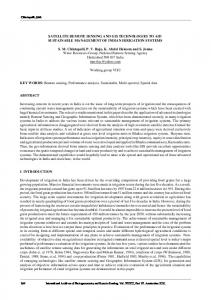
TABLE 1. MEAN LIGHT REFLECTANCE OF HYDRILLA, WATERHYACINTH, ASSOCIATED PLANT SPECIES AND WATER AT THE GREEN, RED, AND NEAR-INFRARED WAVELENGTHS. MEASUREMENTS WERE MADE ON THE RIO GRANDE RIVER NEAR BROWNSVILLE, TEXAS, A POND NEAR SAN BENITO, TEXAS, THE FRIO RIVER NEAR TILDEN, TEXAS, AND THE ATASCOSA RIVER NEAR PLEASANTON, TEXAS. MEANS WITHIN A COLUMN AT EACH DATE OF SAMPLING FOLLOWED BY THE SAME LETTER DO NOT DIFFER SIGNIFICANTLY AT THE 0.05 PROBABILITY LEVEL, ACCORDING TO DUNCAN’S MULTIPLE RANGE TEST. Reflectance (%) for three wavelengths Date
Plant species or water
Green
Red
Near infrared
July 1998 Brownsville, TX
Guineagrass Hydrilla (surface) Water stargrass Waterhyacinth Deep water (>1.0 m) Shallow water(1.0 m) Shallow water (1.0 m) Shallow water (