Combining agent-based and stock-flow modelling approaches in a participative analysis of the integrated land system in Reichraming, Austria Veronika Gaube,1,* Christina Kaiser,2 Martin Wildenberg,1 Heidi Adensam,3 Peter Fleissner,4 Johannes Kobler,5 Juliana Lutz,1 Andreas Schaumberger,6 Jakob Schaumberger,6 Barbara Smetschka,1 Angelika Wolf,1 Andreas Richter,2 Helmut Haberl1 1
Institute of Social Ecology, Faculty for Interdisciplinary Studies, Alpen Adria University, Schottenfeldgasse 29, 1070 Vienna, Austria 2 Department of Chemical Ecology and Ecosystem Research, Vienna Ecology Centre, Faculty of Life Science, University of Vienna, Althanstrasse 14, 1090 Vienna, Austria 3 Austrian Energy Agency, Mariahilfer Straße 136, 1150 Vienna, Austria 4 Institute of Design and Assessment of Technology, Vienna University of Technology, Argentinierstr. 8 / 187, 1040 Vienna, Austria 5 Department for Ecosystem monitoring and research, Umweltbundesamt, Spittelauer Lände 5, 1090 Vienna, Austria 6 Institute for Plant Production and Cultural Landscape, LFZ Raumberg-Gumpenstein, Altirdning 11, 8952 Irdning, Austria
* Corresponding author:
[email protected]
Key words: Agent-based model, Carbon flows, Land-change science, Integrated modelling, Nitrogen flows, Scenario analysis, Socio-ecological systems, Stock-flow model.
The original publication is available at http://www.springerlink.com/content/2154v47380474673/
Published as: Gaube, Veronika, Christina Kaiser, Martin Wildenberg, Heidi Adensam, Peter Fleissner, Johannes Kobler, Juliana Lutz, Andreas Schaumberger, Jakob Schaumberger, Barbara Smetschka, Angelika Wolf, Andreas Richter, Helmut Haberl, 2009. Combining agent-based and stock-flow modelling approaches in a participative analysis of the integrated land system in Reichraming, Austria. Landscape Ecology, 24 (9), 1149-1165. doi: 10.1007/s10980-009-9356-6
2
Abstract The integrated modelling of coupled socio-ecological systems in land change science requires innovative model concepts capable of grasping the interrelations between socioeconomic and natural components. Here we discuss the integrated socio-ecological model SERD (Simulation of Ecological Compatibility of Regional Development) that was developed for the municipality of Reichraming in Upper Austria in a participative two-year process involving local stakeholders. SERD includes three main components: (1) An agent-based actors module that simulates decisions of farmsteads, the municipal administration and other important actors; (2) a spatially explicit (GIS based) land-use module that simulates land-use change at the level of individual parcels of land and (3) an integrated socio-ecological stockflow module that simulates carbon and nitrogen flows through both socioeconomic and ecological system compartments. We report on outcomes of a scenario analysis that outlines possible future trajectories depending on both external (e.g., agricultural subsidies and prices) and internal (e.g., innovation, willingness to co-operate) factors. We find that both external and internal factors can affect the behaviour of the integrated system considerably. Local and regional policies are found to be able to counteract adverse global socioeconomic conditions to some extent, but not to reverse the trend altogether. We also find strong interdependencies between socioeconomic and ecological components of the system. Fully evaluating these interdependencies is, however, not possible at the local scale alone and will require explicit consideration of higher-level effects in future research.
Published as: Gaube, Veronika, Christina Kaiser, Martin Wildenberg, Heidi Adensam, Peter Fleissner, Johannes Kobler, Juliana Lutz, Andreas Schaumberger, Jakob Schaumberger, Barbara Smetschka, Angelika Wolf, Andreas Richter, Helmut Haberl, 2009. Combining agent-based and stock-flow modelling approaches in a participative analysis of the integrated land system in Reichraming, Austria. Landscape Ecology, 24 (9), 1149-1165. doi: 10.1007/s10980-009-9356-6
3
Introduction Understanding feedbacks between socioeconomic and natural components of the integrated land system is a key goal of sustainability science (Kates et al. 2001). The notion of “land system” emphasizes that the Earth’s lands are coupled socio-ecological (or humanenvironmental) systems in which both socioeconomic and natural factors interact in shaping patterns and dynamics (GLP 2005; Turner et al. 2007). Integrated socio-ecological models capable of simulating interactions between socioeconomic trajectories, land-use change and socio-ecological flows of energy, materials and substances are crucial in helping to analyze patterns and trajectories of socioeconomic and natural drivers as well as feedbacks between them (Berger et al. 2006; Manson and Evans 2007; Parker et al. 2003; Parker et al. 2008; Valbuena et al. 2008) In order to contribute to the design and implementation of such models, we report on the integrated socio-ecological model SERD (Simulation of Ecological Compatibility of Regional Development) that was developed for the municipality of Reichraming in Upper Austria in a participative two-year process involving local stakeholders. SERD includes three main components: (1) An agent-based actors module (ABM) that simulates thedecisions of important actors such as farmsteads, the municipal administration and others; (2) a spatially explicit (GIS based) land-use module (LUM) that simulates land-use change at the level of individual parcels of land and (3) an integrated socio-ecological stock-flow module (SFM) that simulates carbon and nitrogen flows through both socioeconomic and ecological system compartments (e.g., carbon (C) contained in fossil fuels as well as C assimilated by plants and all consequent C flows such as inputs to the soil or harvest by humans or livestock). Reichraming is located in the midst of the emerging Long-Term Socio-Ecological Research (LTSER) platform Eisenwurzen. This LTSER platform is part of a network of such research facilities that is currently being established throughout Europe as an infrastructure to promote the integrated socio-ecological study of local and regional aspects of global change (Singh et al. 2008). The analysis of land system change is a key component of LTSER (Haberl et al. 2006). Reichraming is a mountainous municipality with over 80% forest cover, much of which is managed by Austria’s state owned forest administration ÖBf. A considerable fraction of Reichraming’s 1,800 inhabitants commute to work due to a lack of local jobs. Most of the 60 farms raise cattle and produce milk. The national park “Kalkalpen” (i.e. limestone Alps) covers about one third of Reichraming’s area of approximately 100 km2. The Eisenwurzen is located in Austria’s northern limestone Alps, a mostly hilly or lower mountain region with some higher peaks and flat parts. The region has a longstanding history of metal mining and metallurgy (iron, manganese, bauxite, lead and others) that goes back over 500 years. Around 400 years ago, the amount of iron produced in the region was about 15% of Europe’s total iron production at that time. In pre-fossil-fuel times there was a heavy draw on the region’s forests, both due to the necessary supply of fuel wood and the requirement to feed a large non-agricultural population of miners, workers in metallurgical facilities and forestry workers based on the region’s low-input/low-output agrarian land-use systems. Since the advent of large-scale coal use, railways and industrialized metal smelting and metallurgy, most mines have been abandoned and metal smelting is now concentrated in Published as: Gaube, Veronika, Christina Kaiser, Martin Wildenberg, Heidi Adensam, Peter Fleissner, Johannes Kobler, Juliana Lutz, Andreas Schaumberger, Jakob Schaumberger, Barbara Smetschka, Angelika Wolf, Andreas Richter, Helmut Haberl, 2009. Combining agent-based and stock-flow modelling approaches in a participative analysis of the integrated land system in Reichraming, Austria. Landscape Ecology, 24 (9), 1149-1165. doi: 10.1007/s10980-009-9356-6
4 industrial centres at the fringes or outside the region, e.g. in the city of Linz. Most of the Eisenwurzen is of marginal agricultural productivity. Forests are re-growing rapidly, in parts of the region to an extent that it is regarded as a burden by the local population. The region typically experiences problems of marginalized rural areas such as declining agriculture, a lack of jobs, low incomes and creeping deterioration of infrastructure. (Landeskulturdirektion Oberösterreich 1998).
Integrated modelling methods Objectives of the model development The first class of objectives of SERD was scientific, above all the model´s ability to integrate a wide variety of societal as well as natural drivers, patterns, processes and outcomes. In other words, SERD can be used to focus on interaction processes between socioeconomic and natural components of the integrated land system (GLP 2005; Turner et al. 2007). From a scientific perspective, the aims of model building were to simulate (1) decisions and activities of relevant actors such as farmsteads, households, the national park, the forest administration, the municipality and private enterprises, (2) the development of land use for grassland agriculture, settlement and forestry, and (3) C and nitrogen (N) stocks and flows in both socioeconomic (farms, households, companies) and ecological systems. SERD thereby aimed to contribute to the LTSER agenda that seeks to develop a long-term understanding of integrated socio-ecological systems depending on globalization and global environmental change (Haberl et al. 2006). A second class of objectives was related to SERD’s ability to support local stakeholders in vision-finding and strategic orientation processes in order to strengthen their ability to initiate useful interventions. In order to maximize SERD’s usefulness for local stakeholders, the whole process of model design was based on a participatory process involving different stakeholder groups throughout the entire project lifetime of two years. SERD was developed to help answer problem-oriented research questions that have relevance to local stakeholders and can tackle with the scientific resources at hand, e.g. how can rates of forest re-growth be reduced to create income opportunities for farmers? How would different external framework conditions affect Reichraming’s land system and what can local and regional actors do to change its trajectory? SERD was thus constructed as a model aimed at simulating future scenarios depending on changes in external framework conditions. These included economic factors (e.g., agricultural or energy prices), political factors (e.g. subsidies and regulations) and social factors (e.g. leisure time preferences and minimum income requirements). We also aimed to simulate the dependence of trajectories on internal decisions such as increased cooperation between farmers and implementation of policies to increase bio-energy production.
Participatory process In order to ensure that SERD would be useful to relevant stakeholders, we embarked on a trans-disciplinary research design that included a structured participation process following Published as: Gaube, Veronika, Christina Kaiser, Martin Wildenberg, Heidi Adensam, Peter Fleissner, Johannes Kobler, Juliana Lutz, Andreas Schaumberger, Jakob Schaumberger, Barbara Smetschka, Angelika Wolf, Andreas Richter, Helmut Haberl, 2009. Combining agent-based and stock-flow modelling approaches in a participative analysis of the integrated land system in Reichraming, Austria. Landscape Ecology, 24 (9), 1149-1165. doi: 10.1007/s10980-009-9356-6
5 successful examples from sustainability science (Brand 2000; Hare and Pahl-Wostl 2002; Jahn 2005; Newig et al. 2008; Pahl-Wostl 2002; Rowe and Frewer 2005). In the participatory research approach, social goals and visions for the future were translated into scientific categories and consequently into a formalised modelling language. During the project lifetime, three different stakeholder groups were established, each of which met several times. These included 1) representatives of the municipal administration, the ÖBf and business managers, 2) women and 3) farmers representing the variety of agricultural practices prevalent in the municipality. Group meetings were organized by the project team. The agenda of the meetings was structured by model requirements and outcomes. The model thereby supported a systematic discussion structure on identical issues within different stakeholder groups. All data and assumptions flowed into the model and the results were discussed in these different settings. The modelling software used (AnyLogic) supports easy use of the model at an early stage of the model development process. Interface elements (such as sliders and graphs) can easily be implemented allowing users such as regional stakeholders to test model versions at all stages of model development and to comment on preliminary results – thereby providing feedback that helps to improve assumptions in the next model version. In particular, the participatory process contributed to and reflected on the information required for the design of the agent-based model which was in turn applied as a guiding tool in the participatory process to help local actors reflect on the present and the future as well as in developing strategies and policy priorities to provide the basis for discussions (D'Aquino et al. 2003). The design of the user interface – that is, the decisions from which parameters were to be visualized or manipulated in the interface – was also a crucial task of the participatory process. Different stakeholder groups worked on the interface design in different settings, thereby solving the challenging task of creating a version of the interface upon which all groups could agree.
Overall model structure and feedbacks between modules According to its objectives, SERD was constructed to simulate socioeconomic patterns and processes (e.g. income, municipal budget, time use and the number of farms and households) as well as socio-ecological/ecological patterns and processes (e.g. land use, land cover, plant growth and harvest and fossil fuel consumption). Both external and internal factors can be modified during model runs through sliders on the model’s user interface. Sliders are elements on the simulation display that allow users to experiment with changes of internal and external factors, thereby allowing the user to assess the impacts of these factors on the trajectory of the model. Examples include agricultural prices, subsidies, willingness to cooperate, leisure time and income preferences. Sliders therefore allow for an interactive use of the model. Outputs include indicators of land-use change, greenhouse gas (GHG) emissions and the aggregated C or N balance as well as indicators of socioeconomic parameters such as municipality budget and household numbers. Overall, the model requires the input of c 300 input factors. For all of these default values are provided based on levels observed in 2006, the year model construction started. The model internally processes about c 1,000 factors and calculates c 30 output parameters. Additional information on SERD is
Published as: Gaube, Veronika, Christina Kaiser, Martin Wildenberg, Heidi Adensam, Peter Fleissner, Johannes Kobler, Juliana Lutz, Andreas Schaumberger, Jakob Schaumberger, Barbara Smetschka, Angelika Wolf, Andreas Richter, Helmut Haberl, 2009. Combining agent-based and stock-flow modelling approaches in a participative analysis of the integrated land system in Reichraming, Austria. Landscape Ecology, 24 (9), 1149-1165. doi: 10.1007/s10980-009-9356-6
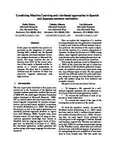
6 available through the supplementary online material to this article at http://www.springerlink.com/content/2154v47380474673/ (Supplemental material: Tables S1-S3, Figures S1-S4) and in Gaube et al. (2008). The overall structure of SERD is outlined in Figure 1, the middle part of which shows the model’s three major modules: The agent-based actors’ module (ABM), the GIS-based landuse and land-cover module (LUM) and the integrated socio-ecological stock-flow module (SFM). Feedbacks between the ABM and the SFM mostly proceed via the LUM. For example, if farmers decide to change the use of a parcel of land, this affects the area under a defined land use (e.g. cattle grazing) or farming intensity (e.g. amount of fertilizer per hectare and year). Direct feedbacks between ABM and SFM can also occur. For example, households or companies may switch between fuels (e.g. heating oil or wood) and thereby affect the system’s C balance. Decision tree of a farm-agent in the agent-based model1
External conditions
N balance Farm N turnover
N Fodder
adaptation strategy labour market
extent
livestock
Concentrated feed
evaluate unsatisfied
more external workers
Simplified figure of the C and N stock and flow model of a farm3 Farm
PASSIVE
rent
Overarching concept of the integrated model2
change of production
Agent Based Module
forest grow th
Land use rent PASSIVE
Integrated stockflow module
rent
Model outputs
livestock pasture
N excretions pasture
Yield
Manure
available N
Forest Area Tree species Age Cultivation C/N soil C/N vegitation
N excretions
livestock
Grassland Area Cultivation type BIOME BGC
C/N Stock
Figure 1. Concept of the integrated model. 1 Example of a generalised decision tree of a farm implemented in the agent-based module. 2 Interactions of the two model components agent-based module and stock-flow module with a land-use model as linking element. 3 Overview of the ecological carbon and nitrogen stock and flow module of a farm.
With respect to scales, SERD integrates processes at the level of actors, individual parcels of land and the terrestrial ecosystems they support, and system-level patterns and processes emerging from the interactions between the individual units. At present, all processes beyond the municipal level are external to SERD and have to be fed into the model before or during model runs as input parameters. In principle, it would be possible to embed SERD in a largerscale model, e.g. a macroeconomic model of Austria that would endogenously determine many of SERD’s inputs and deal with its outputs. The model could also be extended to consider impacts of climate change in terms of both adaptation and mitigation measures and Published as: Gaube, Veronika, Christina Kaiser, Martin Wildenberg, Heidi Adensam, Peter Fleissner, Johannes Kobler, Juliana Lutz, Andreas Schaumberger, Jakob Schaumberger, Barbara Smetschka, Angelika Wolf, Andreas Richter, Helmut Haberl, 2009. Combining agent-based and stock-flow modelling approaches in a participative analysis of the integrated land system in Reichraming, Austria. Landscape Ecology, 24 (9), 1149-1165. doi: 10.1007/s10980-009-9356-6
Animal products
CH4 NH3 co2 N emiss
N leach
7 strategies. Resource limitations have, however, so far not allowed implementation of such feedbacks. Interactions between social (e.g. time use), economic (e.g. income) and ecological (e.g. land use and C and N flows) aspects of sustainability were at the core of model development from its inception. All three SERD modules include social, ecological and economic parameters, therefore the model is not merely a coupled model framework based on the addition of existing social, economic and ecological models – rather, all modules were developed almost from scratch with understanding of the ‘society-nature’ interaction as the main goal. The agent-based module (ABM) The ABM was created through the participative process as described above. This entailed indepth cooperation with local stakeholders using methods such as focus groups, workshops, indepth expert interviews (face-to-face) and survey techniques, including a survey of 54 farms. Decision trees and probabilities for certain actions were also developed through this process. In addition, we used information drawn from statistical databases (e.g. BMLFUW 2006) and scientific literature (Balmann 1997; Bell and Irwin 2002; Berger et al. 2006; Happe et al. 2006; Parker et al. 2002; Parker et al. 2003). The ABM integrates the following actors or groups of actors that were considered to be most relevant in terms of land-use decisions: farmers (each farmer is one agent), households (implemented as one aggregated agent), the municipal administration, the national park administration, the federal forest agency (ÖBf), private enterprises (we differentiated three types of companies, bio-energy firms, tourist companies and others) and finally tourists (one aggregated agent). We used two different types of agents; (1) “Aggregated agents” were technically implemented as one agent with one decision tree, this agent stands for a group of single actors. Therefore, this type of agent is characterized by a parameter indicating the number of its members (e.g. households, tourists, companies), (2) Individual actors include the municipal administration, the ÖBf, the national park administration and all farms. All of these actors were implemented as “individual agents”, each characterized by a specific decision tree. Farms are SERD’s most complex agents. Each individual farm is characterized by the parcels of land it owns, by its livestock and other production-relevant data that also determine its decision tree (see left part of Figure 1, Figure S1 and Table S1). Data were taken from statistics (e.g. BMLFUW 2006) and from a survey in which each farm family was asked to fill in a questionnaire. Parameters include data on demography, time use for production and family reproduction (e.g. child care), size and type of cultivated land and forest, intensity of production, income from subsidies, agricultural production, non-agricultural work on the farm or as employees. Each step of the calculation simulates one year. In each step, the farm evaluates its internal situation in terms of income and time use and its external environment in terms of subsidies, market prices for agricultural products, labour market, conditions for bioenergy, accessible infrastructures, etc. If the farm fails to achieve a predefined minimum income or minimum leisure time, the farm reacts according to its decision tree, for example by changing type or intensity of land-use, seeking employment on the labour market,
Published as: Gaube, Veronika, Christina Kaiser, Martin Wildenberg, Heidi Adensam, Peter Fleissner, Johannes Kobler, Juliana Lutz, Andreas Schaumberger, Jakob Schaumberger, Barbara Smetschka, Angelika Wolf, Andreas Richter, Helmut Haberl, 2009. Combining agent-based and stock-flow modelling approaches in a participative analysis of the integrated land system in Reichraming, Austria. Landscape Ecology, 24 (9), 1149-1165. doi: 10.1007/s10980-009-9356-6
8 changing its willingness to co-operate with other farmers, abandoning farming etc. (Figure S1 and Table S1). The main functions of the national park administration and the federal forest agency (ÖBf) simulated in SERD are that they act as land owners. The national park simply protects its area according to predefined rules. The ÖBf acts by renting abandoned farm land and managing it as forestry areas. Co-operation between farms and the national park are assumed to have a positive impact on the attractiveness of Reichraming to tourists. The municipal administration may decide on investments for infrastructure for tourists, companies and households. Decisions taken by the municipality have to consider the municipality budget, which in turn is calculated based on the number of households, companies and tourists. Another activity of the municipality is the rededication of land as building land. Whenever land is taken out of farming, the municipal administration has the opportunity to decide whether or not to rent this land. Companies demand labour and thereby supply jobs for the people living in Reichraming. Whenever the framework conditions are favourable for the establishment of companies, for example through positive conditions for bio-energy, the number of available jobs increase, which improves the attractiveness of Reichraming as settlement area (resulting in increasing population and household numbers) and decreases the percentage of commuters in the total work force. However, intensive housing development and additional companies have a negative impact on the landscape that may in turn decrease the attractiveness for tourists as well as for households. The two aggregated agents households and tourists mainly indicate how decisions of other actors and the development of framework conditions affect the number of households and tourists. These numbers again influence the municipality budget, the availability of work force, the demand for building land, etc. Interactions between the agents proceed through two distinct pathways: (1) the model contains a suite of system parameters that are changed by decisions and actions of all actors. These system parameters describe the favourability of the current state of the system for each actor or actor group which then, in turn, influences the decisions of the actors in the following years (see Figure S2 and Table S2). (2) Direct interactions between agents occur via the rental land market. If farms have to, or want to, reduce the area of land they cultivate, they deposit the information on size and quality of this land on the rental market. In the same year, farms, the municipality and the ÖBf request land on the same market. Whenever the requirements of a consumer and a supplier match to at least 70%, with respect to the size of the area, a transaction can proceed. First other farms get the chance to rent offered land, then the municipality and in a final step the ÖBf, has the possibility to rent the remaining land. Decisions and interactions of the social actors in the ABM result in a change of land use in terms of land-use category and intensity of land use, i.e. they represent an input to the LUM. The outputs of the ABM are also inputs for the SFM as explained below. The land-use module The land-use and land-cover module (LUM) simulates land-use change in a spatially explicit way based on existing GIS data and data on land tenure going down to the level of single parcels of land and farmsteads. The LUM is an MS Access database in which each parcel of Published as: Gaube, Veronika, Christina Kaiser, Martin Wildenberg, Heidi Adensam, Peter Fleissner, Johannes Kobler, Juliana Lutz, Andreas Schaumberger, Jakob Schaumberger, Barbara Smetschka, Angelika Wolf, Andreas Richter, Helmut Haberl, 2009. Combining agent-based and stock-flow modelling approaches in a participative analysis of the integrated land system in Reichraming, Austria. Landscape Ecology, 24 (9), 1149-1165. doi: 10.1007/s10980-009-9356-6
9 land is characterized by a unique ID and a vector of parameters (i.e. land use, land-use intensity, land cover, geographic coordinates, soil data and altitude). The database can be linked with a GIS that is external to SERD to visualize the results of model runs. The area owned by each farm in the ABM is defined by a list of parcel IDs (Figure S3). If a farm decides to rent out a parcel or to change its land-use type or intensity, the characterization in the database is changed and the information is passed on to the SFM. The SFM then simulates biophysical stocks and flows that are transmitted to the ABM via the LUM. In other words, the LUM is not in itself a dynamic model. It rather serves as an interface between ABM and SFM as well as an interface to the GIS used to visualize outcomes of model runs. The stock-flow module In designing the stock-flow module (SFM), we opted against the possibility of using existing ecological models to simulate C and N flows in ecosystems because this would have resulted in an extreme imbalance in the complexity of SERD’s socioeconomic and natural parts. This would have been counter to our goal of focusing on the interface between socioeconomic and ecological dynamics. The stock-flow module calculates socio-ecological substance flows of carbon and nitrogen (C, N) using a system-dynamic approach. Carbon and N flow calculations for agro-ecosystems and forests were calibrated using factors derived from model runs of the much more complex ecosystem model Biome-BGC (Petritsch et al. 2007; Pietsch et al. 2005; Pietsch and Hasenauer 2006). Stocks and flows of C and N are calculated in the SFM for the whole area of Reichraming. The module is separated into the following compartments: farms (including grassland parcels), federal forest and national park (including forest parcels) and economic activities of households and companies (Figure S4). Natural C and N flows (photosynthetic CO2 assimilation, ecosystem respiration, N leaching, etc.) are simulated in a spatially explicit manner based on high-resolution digital maps including detailed data on altitude, soil and vegetation type, tree age, climate and type of cultivation for c 400 grassland and c 2000 forest parcels. These calculations were performed external to SERD using the above cited modified version of the biogeochemical ecosystem model BIOME-BGC (Table S3). Anthropogenic C and N flows from farming (e.g. N2O and NH3 emissions from manure management and fodder conservation, CH4 emissions from animal digestion, C and N loss by exported animal products, net CO2 exchange between grassland parcels and atmosphere, CO2, CH4 and N2O emissions from the use of concentrated feed and fossil fuel) and forestry (e.g. tree yield, wood transport, forest management) are calculated by SERD. Net C losses from the soil as a result of cultivation are considered through the difference between NPP and the sum of heterotrophic soil respiration and C removed from the field by harvesting (C in yield is counted as CO2 loss, since it is lost to the atmosphere in the medium term). The C and N cycle for farms is calculated for each farm on a yearly basis, considering all parcels and livestock belonging to that farm in the respective year as well as each farm’s management decisions regarding type and intensity of farming. The C and N cycle for forestry is calculated on a yearly basis for the two main forest enterprises in Reichraming (the ÖBf and the national park) that differ in their management strategies: the ÖBf runs a state-of-the-art forestry Published as: Gaube, Veronika, Christina Kaiser, Martin Wildenberg, Heidi Adensam, Peter Fleissner, Johannes Kobler, Juliana Lutz, Andreas Schaumberger, Jakob Schaumberger, Barbara Smetschka, Angelika Wolf, Andreas Richter, Helmut Haberl, 2009. Combining agent-based and stock-flow modelling approaches in a participative analysis of the integrated land system in Reichraming, Austria. Landscape Ecology, 24 (9), 1149-1165. doi: 10.1007/s10980-009-9356-6
10 management system on an economic (cost-benefit optimization) basis and the national park stopped tree logging the year it came into being (1997). The National Park therefore fulfils only preservation functions, allowing its forest to grow back to natural conditions on most of its area (some forestry is allowed on its fringes). In SERD, tree cutting leads to different C flows according to the turnover times of different wood products. A part of the C is lost to the atmosphere in the same year (firewood), a part has a turnover time of a few years (paper) and a part has a turnover time of 15 to 70 years (timber) (Burschel et al. 1993). The proportions of firewood, paper and timber depend on tree types (deciduous or evergreen). The calculation of CO2, CH4 and N2O emissions from households and enterprises is based on type and age of construction as well as the energy source used for heating and electricity. The mix of oil, wood, electricity and gas for heating can change during a model run according to the attitude of the citizens to renewable energy. Model outputs from the ecological model are C and N stocks and flows and C and N balances at different levels (landscape, farming, forestry, and municipality). Additionally, the model outputs include indicators for sustainable farming such as N losses and internal N cycling on a farm basis as well as aggregate GHG emissions. Net GHG emissions are calculated from CO2, CH4 and N2O emissions according to the weighting factors given in the IPCC report of 2007 (CH4: 72 CO2 equivalents; N2O: 289 CO2 equivalents; IPCC 2007). Net CO2 assimilation by forests and grassland is subtracted from GHG emissions. Scenario assumptions We used SERD as a tool to simulate future scenarios depending on changes in (1) external framework conditions, (2) local and regional policies and (3) preferences of individual agents with respect to income and leisure time expectations, willingness to co-operate, etc. Inspired by well-known international or even global scenarios (Millenium Ecosystem Assessment 2005; Nakicenovic and Swart 2000; UNEP 2002), we developed assumptions for future developments of external framework conditions in three scenarios which we contrasted with a reference (REF) scenario that carries forward the initial values as inputs. Assumptions on local and regional policies as well as on the preferences of local agents were developed in the participatory process described above. The REF scenario assumed that the conditions of 2006 remain constant over the 30 years of the simulation period. The REF scenario demonstrated how the future could unfold if neither external nor internal factors were to change over the next decades. It was used as a baseline with which trajectories in other scenario runs were compared. The reason for using a REF scenario approach was that regions in rural areas in Austria are currently in a dynamic structural changing phase and many important framework conditions changed considerably during the creation of the model (2005-2008). At present it is not possible to decide whether the conditions of 2006 or those of the first half of 2008 are more likely to prevail over the next 30 years, so we decided to calculate two projections (REF and TREND) against which other scenarios are compared. A comparison of the initial values with scenario results would not allow for reliable conclusions, as the system is neither stable under 2006 conditions nor under those of the first half of 2008.
Published as: Gaube, Veronika, Christina Kaiser, Martin Wildenberg, Heidi Adensam, Peter Fleissner, Johannes Kobler, Juliana Lutz, Andreas Schaumberger, Jakob Schaumberger, Barbara Smetschka, Angelika Wolf, Andreas Richter, Helmut Haberl, 2009. Combining agent-based and stock-flow modelling approaches in a participative analysis of the integrated land system in Reichraming, Austria. Landscape Ecology, 24 (9), 1149-1165. doi: 10.1007/s10980-009-9356-6
11 In simulating the TREND scenario (Table 1) we assumed current (first half of 2008) conditions and trajectories. In particular, we assumed a doubling of agricultural prices over the 2006 level as well as strongly improved conditions for use and production of bio-energy. Agricultural subsidies and EU subsidies for the municipality as well as internal strategies and behaviour remained unchanged. Thus, the TREND scenario simulated the impact of global improvements in terms of agricultural prices and bio-energy on a region dominated by agriculture and forestry such as Reichraming. The third scenario, entitled “neo-liberal globalization” or GLOB, assumed a wide-spread adoption of neo-liberal economic policies with unlimited availability of natural resources; that is, a drop of agricultural prices and an abandonment of agricultural subsidies. In this scenario we assumed that prices for agricultural products drop to 50% of their 2006 value. Agricultural subsidies and national-level subsidies for the municipality were cancelled and global conditions for bio-energy became less favourable, either due to falling fossil fuel prices or a cessation of climate policies or both. In addition to these external framework conditions, the behaviour of agents changed to a minimum willingness for co-operation on the municipality level as well as on the farm level and to a preference for shifting to alternative strategies in the agricultural sector such as direct marketing. The willingness of farmers to rent land to the ÖBf was increased to 90%. This scenario simulated the local impacts of the most negative trends for the agricultural sector on the global scale with the additional assumption that no strategies were implemented on the local or regional level to counter these developments. The fourth scenario entitled “local and regional policy” (LOC) assumed that the external trends developed in a similar way to those in the GLOB scenario, but that local and regional stakeholders (above all, municipal and provincial policy-makers) would implement innovative strategies to try and counteract these conditions. Although agricultural incomes were limited by low agricultural product prices and an absence of agricultural subsidies, farms were highly motivated to change to innovative production strategies, to co-operate with each other and with the national park, to shift to organic farming and to invest in direct marketing activities. The share of regional products daily consumed by the households of Reichraming increased. In parallel, the municipality was assumed to be open to co-operate with neighbouring municipalities in order to create a better regional labour market. We also assumed that due to engaged regional policies, subsidies for the municipality from the national level would double in comparison to the reference scenario. Thus, this scenario assessed the ability of regional strategies to cope with disadvantageous framework conditions.
Published as: Gaube, Veronika, Christina Kaiser, Martin Wildenberg, Heidi Adensam, Peter Fleissner, Johannes Kobler, Juliana Lutz, Andreas Schaumberger, Jakob Schaumberger, Barbara Smetschka, Angelika Wolf, Andreas Richter, Helmut Haberl, 2009. Combining agent-based and stock-flow modelling approaches in a participative analysis of the integrated land system in Reichraming, Austria. Landscape Ecology, 24 (9), 1149-1165. doi: 10.1007/s10980-009-9356-6
12
Table 1: Internal and external variable values of the three scenarios TREND GLOB and LOC in comparison with the REF scenario.
Scenario REF1 (1) Sliders changing external variables Prices for agricultural products default Conditions for organic farming default Conditions for bio-energy default Agricultural subsidies default (2) Sliders changing internal variables Co-operation between communities default Co-operation between farms default Direct marketing default National park investments default (3) External variables Agricultural product prices = 2006* Agricultural subsidies (EU, national) = 2006* Additional income direct marketing €400.-/ha EU subsidies for municipality (i.e. LEADER+ etc) [€ per year] 100.000.Households using wood for heating 58% Working hours for direct marketing 40h/ha (4) Changes in decision probabilities of the farms Probability for Extensification vs. Cooperation or Abandonment 50% Probability for Co-operation vs. Abandonment 50% Probability for reinting forest to the ÖBf vs. using the forest in co-operation 50% Probability for regional marketing vs. non-agricultural labour 40% Probability for afforestation vs. renting land to other farmers 30% Probability for shifting to organic farming 99%
Scenario TREND2
Scenario GLOB3
Scenario LOC4
max default max default
min min default min
min max default min
default default default default
min min min min
max max max max
+100% = 2006* €400.-/ha
-50% -100% None
-50% -100% €600.-/ha
100.000.90% 40h/ha
0.58% 0
200.000.58% 300h/ha
50%
50%
50%
50%
10%
90%
50%
99%
0,1 %
40%
0%
100%
100%
30%
30%
99%
0%
100%
1
Reference Scenario: conditions of 2006 remain constant over the 30 years of the simulation period Trend Scenario: current (=2008) conditions and trajectories, in particular, doubling of agricultural prices over the 2006 level and improved conditions for bio-energy 3 Neo-liberal globalization Scenario: neo-liberal economic policies with a drop of agricultural prices and agricultural subsidies 4 Local and regional policy Scenario: neo-liberal economic policies, but local and regional stakeholders implement innovative strategies to counteract these conditions 2
Published as: Gaube, Veronika, Christina Kaiser, Martin Wildenberg, Heidi Adensam, Peter Fleissner, Johannes Kobler, Juliana Lutz, Andreas Schaumberger, Jakob Schaumberger, Barbara Smetschka, Angelika Wolf, Andreas Richter, Helmut Haberl, 2009. Combining agent-based and stock-flow modelling approaches in a participative analysis of the integrated land system in Reichraming, Austria. Landscape Ecology, 24 (9), 1149-1165. doi: 10.1007/s10980-009-9356-6
13
Results Results of the model runs for the next 30 years (i.e. up to the year 2037), are summarized in Table 2. Some changes, when compared to the initial situation in 2007, can be identified in all four scenarios. Grassland areas decrease considerably, coupled with a strong reduction of the number of farms. The proportion of the remaining farms that changes their production to an innovative farming type (e.g. rearing of sheep, horses and game animals) grows considerably. The average farm size falls from 40 ha per farm to around 20 ha per farm, including grassland and private forest area. Annual agricultural working time per farmer increases in all scenarios, but with variable extent, in line with an increasing annual income per farmer through agricultural labour. Table 2: Results of the three scenarios in the year 2037 in comparison to the reference model run
Number of farms Grassland area [ha] Percent of innovative farms Average farm size [ha] Yearly labour time per farmer [hours] Yearly income per farmer [€] Intensive farming area [ha] Conventional farming area [ha] Extensive farming area [ha] Number of households Percentage of commuters [%] Municipality budget {mio. €] Number of tourists per year GHG emissions from farming per ha [t CO2-equiv./ha grassland] Net CO2-Assimilation of forests per ha [t CO2/ha] N2O emissions farms [kg N/ha] N2O emissions forests [kg N/ha] N leaching farms [kg N/ha] N leaching forests [kg N/ha] NH3 emissions farms [kg N/ha] C stock all forests and grasslands [103 t C]
Initial value 52 478 54 40 1 682 16 350 54 295 111 869 74 8 268 2 500
Value in 2037 under Scenarios: Reference TREND GLOB LOC 38 40 36 41 361 383 255 354 74 75 67 68 20 21 18 21 2 313 2 010 2 833 2 721 18 384 21 407 17 871 17 565 86 112 0 75 142 193 76 112 115 60 157 149 823 950 774 840 75 51 77 67 7 978 8 754 7 560 8 166 2 288 2 486 2 028 2 666
5.19
4.36
4.97
4.05
4.90
5.68 2.21 1.81 0.66 0.21 41.49
5.05 2.26 1.37 0.63 0.14 42.21
5.00 2.46 1.38 0.59 0.14 45.69
5.24 1.92 1.36 0.63 0.14 36.51
5.07 2.23 1.37 0.62 0.14 42.29
2 079
2 412
2 394
2 403
2 397
The number of households increases considerably (+10%) in the TREND scenario. Improved conditions for bio-energy enable local forest owners (farms, ÖBf) to sell wood as bio-energy carriers. This has a positive impact on the potential earnings in the agricultural sector for most of the existing farms. In a municipality like Reichraming, with more than 80% forest area, the
Published as: Gaube, Veronika, Christina Kaiser, Martin Wildenberg, Heidi Adensam, Peter Fleissner, Johannes Kobler, Juliana Lutz, Andreas Schaumberger, Jakob Schaumberger, Barbara Smetschka, Angelika Wolf, Andreas Richter, Helmut Haberl, 2009. Combining agent-based and stock-flow modelling approaches in a participative analysis of the integrated land system in Reichraming, Austria. Landscape Ecology, 24 (9), 1149-1165. doi: 10.1007/s10980-009-9356-6
14 establishment of companies that process wood and produce bio-energy creates benefits that in turn improve the regional market conditions for forest owners. As a result, jobs are created and additional added value is produced locally which favours the establishment of new households in the municipality. This generally positive socioeconomic development also shows up in the percentage of commuters which decreases to 50%, despite an increased number of households. Easier access to bio-energy increases the share of households using biogenic heating fuels to 90% (Figure 2 and Table 1). The total number of farms is smallest in the GLOB scenario. Many of the remaining farms switch to extensive farming. The agricultural workload per farmer rises to the largest number of working hours of all scenarios, whereas farm incomes decrease and the chance to establish new companies in the region drops to almost nil. As a result, household numbers decrease heavily in this scenario, suggesting a strong de-population trend. The proportion of commuters grows to the highest value observed in any scenario (75%). A large number of farms are abandoned, negatively affecting the attractiveness of the municipality for tourists and resulting in a strong decrease in the number of tourists per year. The LOC scenario demonstrates how and to what extent regional and local activities can counteract negative framework conditions. The number of households is similar to that in the REF scenario and much higher than in the GLOB scenario. The percentage of commuters even decreases in comparison to the REF scenario, let alone the GLOB scenario. Selected socioeconomic trajectories are shown in Figure 2.
Published as: Gaube, Veronika, Christina Kaiser, Martin Wildenberg, Heidi Adensam, Peter Fleissner, Johannes Kobler, Juliana Lutz, Andreas Schaumberger, Jakob Schaumberger, Barbara Smetschka, Angelika Wolf, Andreas Richter, Helmut Haberl, 2009. Combining agent-based and stock-flow modelling approaches in a participative analysis of the integrated land system in Reichraming, Austria. Landscape Ecology, 24 (9), 1149-1165. doi: 10.1007/s10980-009-9356-6
15
Fig. 2: Results of the scenarios TREND, GLOB and LOC: Socioeconomic trends in number of households and proportion of commuters.
In terms of land use, the maps in Figure 3 show that grassland area is largest in the TREND and LOC scenarios and exceeds the value of the REF scenario by 15%. In the REF and TREND scenarios, grasslands are predominantly managed conventionally, however in the LOC and GLOB scenarios extensively used grasslands play (with a coverage of more than 50%) an important role. In the LOC and TREND scenario, farms adopt the most intensive management styles. Intensively managed grassland areas were largest in the LOC scenario for the first 20 years of the simulation. After this period of time they were largest in the TREND scenario.
Published as: Gaube, Veronika, Christina Kaiser, Martin Wildenberg, Heidi Adensam, Peter Fleissner, Johannes Kobler, Juliana Lutz, Andreas Schaumberger, Jakob Schaumberger, Barbara Smetschka, Angelika Wolf, Andreas Richter, Helmut Haberl, 2009. Combining agent-based and stock-flow modelling approaches in a participative analysis of the integrated land system in Reichraming, Austria. Landscape Ecology, 24 (9), 1149-1165. doi: 10.1007/s10980-009-9356-6
16
Fig. 3: Results of the scenarios TREND, GLOB and LOC: Land use change in the three scenarios in comparison with the land-use map of today.
Overall, the different scenarios affect C and N flows in the respective model runs through change in land use and farming intensity, but also through decisions of households towards renewable energy sources. Figure 4 shows projected accumulative GHG exchange for the time period of 2008-2037 for the area of the municipality of Reichraming for the three different model scenarios. In all three scenarios, forested areas (federal forest, national park, farmstead-owned forests and forestry cooperatives) would constitute a net sink for CO2 from the atmosphere (shown as “negative” GHG emissions, Figure 4). The forests would accumulate on average 1 kg C/ha/year, which is in good accordance with other studies (Schulze et al. 1999, Luyssaert et al. 2008). Because the National Park was established recently (in 1997) and the trees in that area are still relatively young, their capacity to accumulate C from the atmosphere will still be relatively high. Finally, the large area covered by forests (approximately 7 000 ha, compared to only 350 ha of grasslands) in the municipality of Reichraming will lead to a high uptake of CO2 and therefore would contribute to negative net GHG emissions resulting from the C sink of the forested areas (Figure 4, Table 2).
Published as: Gaube, Veronika, Christina Kaiser, Martin Wildenberg, Heidi Adensam, Peter Fleissner, Johannes Kobler, Juliana Lutz, Andreas Schaumberger, Jakob Schaumberger, Barbara Smetschka, Angelika Wolf, Andreas Richter, Helmut Haberl, 2009. Combining agent-based and stock-flow modelling approaches in a participative analysis of the integrated land system in Reichraming, Austria. Landscape Ecology, 24 (9), 1149-1165. doi: 10.1007/s10980-009-9356-6
17 Greenhouse gas emissions of farms and households will strongly depend on the trajectories emerging in the different scenarios, mainly due to different numbers of farms and management intensities and different energy sources for households. Greenhouse gas emissions of farms with livestock farming and pastures will be dominated by emissions of N2O and CH4 due to manure management and animal digestion (Weiske et al. 2006, Soussana et al. 2007). The highest GHG emissions from farming were projected to occur in the TREND scenario (in total 64 kilotons [kt] CO2-equivalents for 2008-2037) due to a prolonged time period in the model run during which intensive farming played a major role. Greenhouse gas emissions will be fairly high in the LOC scenario (59 kt CO2-equivalent for 2008-2037) due to the largest area of intensive farming, especially in the first 20 years of the model run. Agricultural GHG emissions will visibly be reduced in the GLOB scenario (40 kt CO2-eq for 2008-2037) due to the low number of surviving farms (Figure 4, Table 2). Greenhouse gas emissions from households and enterprises would be in the same range as GHG emissions from farms (2-4 kt C/year). Although household numbers are largest in the TREND scenario, GHG emissions from households will be lowest in that scenario due to good conditions for bio-energy that result in a higher percentage of use of renewable energy sources. If the conditions are unfavourable for bio-energy (GLOB scenario) the model shows that this would result in the highest GHG emissions from households per household (Figure 4, Table 2). Figure 4 shows that the model predicts that total GHG emissions in Reichraming from households, enterprises, agriculture, forestry and wood transport would be overcompensated by the capacity of the large forested area to assimilate C. However, this has to be interpreted with caution as the forest C sink depends on the time period being modelled. Thirty years is probably too small a time period to comprise all losses and gains, since rotation times for forests are much longer (up to 120 years) and the turnover time of timber is usually longer as well. The effect of the different scenarios on nitrogen losses (NH3- and N2O-emissions, NO3leaching) are dominated by farming. Agriculture is thought to be the main emitter of NH3 and N2O and is responsible for the biggest part of NO3 leaching due to fertilizers, manure management and animal husbandry (Weiske et al. 2006). The N2O emissions on an areal basis of farms in the model run were almost twice as high as N2O emissions of forested area (2.6 kg N/ha and 1.4 kg N/ha on average for grassland and forests, respectively). However, total N2O emissions originating from forests soil in Reichraming were summed up to be as high as 333339 t N2O-N for the years 2008-2037 in the different scenarios, thereby much higher than cumulated N2O emissions from grassland areas (Figure 4). This is in accordance with the fact that forest soils constitute a relevant source of this greenhouse gas, mainly driven by high amounts of inorganic N deposition (Kesik et al. 2005). Additional, high N2O emissions from forest soils were calculated by the model for grassland parcels which were abandoned and reforested, at least for some years following abandonement (due to higher N availability in previously fertilized soils). The highest effect of the different scenarios on N losses stems from NH3 emissions which are almost exclusively caused by agriculture (livestock farming). A high percentage of animal manure N is usually lost as NH3 emission, mainly during storage and application on the field (Leick 2004, Gac et al. 2007). Consequently, NH3 emissions are highly dependent on the amount of farmed area and farming intensity and will be therefore lowest in the GLOB
Published as: Gaube, Veronika, Christina Kaiser, Martin Wildenberg, Heidi Adensam, Peter Fleissner, Johannes Kobler, Juliana Lutz, Andreas Schaumberger, Jakob Schaumberger, Barbara Smetschka, Angelika Wolf, Andreas Richter, Helmut Haberl, 2009. Combining agent-based and stock-flow modelling approaches in a participative analysis of the integrated land system in Reichraming, Austria. Landscape Ecology, 24 (9), 1149-1165. doi: 10.1007/s10980-009-9356-6
18 scenario (Figure 4). Generally, N losses were not predicted to be very high and reflect the low input agricultural system in Reichraming.
Fig. 4: Accumulated greenhouse gases (GHG) and nitrogen losses for 30 years (2008-2037) for three model scenarios5.
Discussion and conclusions A comparison of the TREND and GLOB scenarios shows the extent to which Reichraming’s future could be influenced by favourable (TREND) or unfavourable (GLOB) external socioeconomic framework conditions. The REF scenario falls between these two extremes. Note that the classification as favourable or unfavourable refers to the local level, i.e. the marginal rural community of Reichraming. The judgment of inhabitants of urban areas or even the macro-economic (national-level) perspective might be the opposite, for example if
5
Greenhouse gas emissions are calculated as CO2-equivalents according to the IPCC report 2007 and comprise of CO2, N2O and CH4 emissions by farming, forestry management, households and company business (“hh & c”) and CO2-exchange of grassland and forests. Negative values represent net CO2-assimilation, positive numbers represent net GHG emissions. N2O losses include N2O emissions through fossil fuel use in farming and forestry management as well as natural N2O emissions of forests and grassland soils and N2O emissions driven by application of manure and livestock farming. NH3 emissions are negligible in forests and are calculated for farms only. Grassland areas in 2037 were projected to cover 363, 233 and 334 ha and forested area is 7414, 7549 and 7457 ha for scenarios TREND, GLOB and LOC, respectively.
Published as: Gaube, Veronika, Christina Kaiser, Martin Wildenberg, Heidi Adensam, Peter Fleissner, Johannes Kobler, Juliana Lutz, Andreas Schaumberger, Jakob Schaumberger, Barbara Smetschka, Angelika Wolf, Andreas Richter, Helmut Haberl, 2009. Combining agent-based and stock-flow modelling approaches in a participative analysis of the integrated land system in Reichraming, Austria. Landscape Ecology, 24 (9), 1149-1165. doi: 10.1007/s10980-009-9356-6
19 aggregate economic growth rates were higher in the GLOB than in the TREND or REF scenario. In addition, high energy prices – a major factor behind favourable conditions for bio-energy – are assumed generally not to be beneficial to the economy at large, however for a region with high bio-energy potentials the advantages may outweigh the disadvantages. Note that due to the fact that general economic conditions on higher system levels are not explicitly modelled (e.g., negative effects of high energy prices on the economy at large that might adversely affect the local economy), we neglect feedbacks from higher system levels on the local economy that might reduce or even reverse such positive effects. Currently, such interactions cannot be ruled out and this represents a shortcoming of the current model version. A comparison of the LOC and the GLOB scenarios reveals the extent to which the trajectory under unfavourable framework conditions for marginal rural areas could be counteracted through vigorous local and regional-level policies and instruments such as improving conditions for organic farming, regional subsidies, co-operation between farms and municipalities, direct marketing and similar activities. Remarkably, results for the agricultural sector were similar in the TREND and the LOC scenarios in terms of number of farms and grassland area remaining under production, despite completely different assumptions and scenario storylines. In the TREND scenario, agricultural framework conditions were relatively favourable in terms of prices and agricultural subsidies, thus allowing farmers to survive economically with an acceptable work load through agricultural work. This will have a positive effect on the quality of life of farmers and will allow many of them to continue farming. Framework conditions were completely different in the LOC scenario with low agricultural prices and no subsidies. In this case, scenario runs suggested that farmers could still survive through increased direct marketing and co-operation between farmers. Their situation was much worse, however, in terms of workload and consequently also in terms of income per working hour spent in agricultural activities. In other words, unfavourable framework conditions could to some extent be compensated through regional and local efforts, but this may require increased efforts in terms of work load and consequently reduce the quality of life. This difference was also reflected in the ecological indicators. GHG emissions from households in the LOC scenario will be twice as high as in the TREND scenario due to lower bio-energy use for heating, despite the fact that the number of households will be highest in the TREND scenario. Thr relationships between socioeconomic and ecological objectives are complex. Some of our results may be interpreted as trade-offs, i.e. socioeconomically favourable scenarios being ecologically less favourable. Farming intensity is highest in the LOC scenario and lowest in the GLOB scenario, reflecting the effort of farmers to counteract adverse framework conditions in the LOC scenario. GHG emissions are lowest in the GLOB scenario, reflecting the decreasing trend in almost all economic activities. Moreover, agriculture is least intensive in this scenario, because there are no incentives for intensive production (subsidies, product prices), and agriculture is primarily continued – if it is continued at all – for other than economic reasons (e.g. traditional farmer’s values). This loss of agricultural activity results in the fact that on the municipal scale modelled here, the GLOB scenario seems to be most favourable from an environmental point of view: Mostly as a result of the shift from grassland
Published as: Gaube, Veronika, Christina Kaiser, Martin Wildenberg, Heidi Adensam, Peter Fleissner, Johannes Kobler, Juliana Lutz, Andreas Schaumberger, Jakob Schaumberger, Barbara Smetschka, Angelika Wolf, Andreas Richter, Helmut Haberl, 2009. Combining agent-based and stock-flow modelling approaches in a participative analysis of the integrated land system in Reichraming, Austria. Landscape Ecology, 24 (9), 1149-1165. doi: 10.1007/s10980-009-9356-6
20 to forests, carbon uptake is highest in this scenario. Over the whole 30-year period, net GHG emissions were projected by the model to be 11% lower than in the REF and LOC scenarios (REF: -641 kt CO2 equivalent, TREND -678 kt, LOC -642 kt, GLOB -715 kt, Figure 4). In terms of N losses, the GLOB scenario is superior to the others, with accumulated NH3 emissions 35% lower than in the other scenarios. This should, however, not be interpreted in terms of a good environmental performance of the GLOB scenario. Firstly population is lowest in this scenario, implying that people move to other areas (or fail to move into Reichraming) potentially living in adjacent urban centres, so that emissions would be higher elsewhere. Secondly, a decreasing agricultural production in Reichraming also reflects the fact that in such a scenario agricultural production is concentrated in favourable (i.e. flat lowland) areas elsewhere that are then used much more intensively (Haberl et al. 2003). This probably reflects shifting of the problem that would only be detected when considered at a higher scale (Fischer-Kowalski and Erb 2003). The scenario calculations therefore show that bio-energy development may be an option to reconcile social, economic and ecological goals and thus contribute to truly sustainable development in marginal rural areas in industrialized countries. Improving conditions for bioenergy, in combination with high prices of primary agricultural products, may induce development paths in marginalized rural areas in which job creation, establishment of new enterprises, reduction of the share of commuters and even increases in population numbers go hand in hand with the preservation of open cultural landscapes with ecologically valuable grassland ecosystems managed at intermediate intensity levels and declining GHG emissions. Of course, Reichraming with its immense percentage of forested area is to some extent exceptional and its example might not be directly transferable to all rural areas. There are also good reasons to envisage bio-energy as just one among many technologies that would have to be fostered in order to contribute to a more sustainable energy system in industrial countries, as a large-scale substitution of bio-energy for fossil fuels might have detrimental effects on ecosystems (Haberl and Erb 2006). But our scenario calculations suggest that regionally welladapted measures to promote bio-energy may be a sustainable option in many rural regions of Europe that could become a major component of regional policies. A comparison of the TREND and GLOB scenarios clearly shows that a failure to implement effective regional development policies including bio-energy promotion may result in higher GHG emissions combined with worse socioeconomic conditions, rural de-population and a large-scale loss of valuable cultural landscapes. This might even lead such regions into a downward spiral because loss of open landscapes reduces the attractiveness of the region to tourists as well as a living space. Promotion of organic farming, agricultural direct-marketing, and co-operation between environmentally aware farming and tourism could also be elements of such a strategy, as a comparison between the GLOB and LOC scenarios suggests. We conclude that the development of integrated models such as SERD facilitates an interdisciplinary discourse that can create added value by integrating knowledge from different scientific disciplines in a coherent model, thereby strengthening our capacity to analyze interdependencies between social, economic and ecological dimensions of regional development. In our experience, the degree of formalization required in model construction has proven to be instrumental in securing an increased quality level in the interdisciplinary cooperation because the development of algorithms and model code ensures that all members of
Published as: Gaube, Veronika, Christina Kaiser, Martin Wildenberg, Heidi Adensam, Peter Fleissner, Johannes Kobler, Juliana Lutz, Andreas Schaumberger, Jakob Schaumberger, Barbara Smetschka, Angelika Wolf, Andreas Richter, Helmut Haberl, 2009. Combining agent-based and stock-flow modelling approaches in a participative analysis of the integrated land system in Reichraming, Austria. Landscape Ecology, 24 (9), 1149-1165. doi: 10.1007/s10980-009-9356-6
21 the research team really understand each other. Modelling is therefore an important research strategy to foster integrated analysis of society-nature interactions, a necessity in current attempts to implement a broad research agenda such as that of Long-Term Socio-Ecological Research or LTSER (Haberl et al. 2006; Singh et al. 2008). In particular we found that implementing feedbacks in a system model and discussing model runs with experts and stakeholders helped in gaining a much deeper understanding of the relative importance of different factors and feedbacks in shaping the overall trajectory of the integrated system. Maybe counter-intuitively, the use of formal models has also proven useful in promoting a transdisciplinary discourse within which stakeholders were integrated in the research process. In particular, the development of the ABM was based on the participative process described above. As a result, we were not only able to generate a model version that was acceptable for different groups, but could also incorporate into the model different perspectives as well as ensure a broad dissemination of the outcomes to the local population. Project resources did not allow a validation of SERD based on simulation of past developments and comparison of model runs with actual trajectories, but the intensive involvement of local stakeholders and numerous experts gave us some confidence that the model outputs are at least qualitatively plausible and reliable. Of course, inclusion of impacts coming from higher-levels as well as the study of past trajectories (“backcasting”) remains desireable. Statistical “validation” was not possible at the time of writing, due to a lack of long-term historical data. The discussions with stakeholders also revealed common themes and questions that we interpreted to be underlying structural barriers to a more prosperous regional development, e.g. a lack of co-operation between farms, between stakeholder groups and between neighbouring municipalities. In our experience, the challenge of contributing to the design of a common model motivated people to reflect on their “own” subsystem and its interrelations with other subsystems, thereby weakening frontiers between traditionally opposing groups. One indicator supporting that assumption is that two groups, women and farmers, are currently continuing to meet regularly and to discuss future options on their own, without the help of the project team, even after the official termination of the project. Possibilities to increase co-operation between farmers (the benefits of which were clearly demonstrated by the scenario analyses) are high on the agenda of these discussions. During this study Reichraming’s mayor acted as project partner and supported all project activities throughout the project lifetime. One concrete outcome of the project is a proposal to be submitted to the EU prepared by the Mayor together with local stakeholders and the regional management agency. This proposal used project results as a scientific basis for an applied project aimed at co-operative activities between different types of farms. We conclude that gaining data and knowledge from stakeholders, letting these data flow into a model that is then put into operation before their eyes, producing sometimes expected, sometimes surprising results, has helped in structuring discourse between scientists and stakeholder groups on possible future developments for the region. That has supported the learning processes and an empowerment of the local population.
Published as: Gaube, Veronika, Christina Kaiser, Martin Wildenberg, Heidi Adensam, Peter Fleissner, Johannes Kobler, Juliana Lutz, Andreas Schaumberger, Jakob Schaumberger, Barbara Smetschka, Angelika Wolf, Andreas Richter, Helmut Haberl, 2009. Combining agent-based and stock-flow modelling approaches in a participative analysis of the integrated land system in Reichraming, Austria. Landscape Ecology, 24 (9), 1149-1165. doi: 10.1007/s10980-009-9356-6
22
Acknowledgements We acknowledge financial support by the Austrian Federal Ministry of Education, Science and Culture for the project “LTSER Eisenwurzen” (proVision) as well as by ALTER-Net, a Network of Excellence funded by the EU within its 6th Framework Programme. We thank the following project collaborators: Helene Blanda, Eva Vrzak, Michaela Zeitlhofer, Stefan Pietsch and Thomas Guggenberger. This research contributes to the Global Land Project (www.globallandproject.org).
References Balmann A (1997) Farm-based modelling of regional structural change: a cellular automata approach. European Review of Agricultural Economics 24:85-108 Bell KP, Irwin EG (2002) Spatially explicit micro-level modelling of land use change at the rural-urban interface. Agricultural Economics 27(3):217-232 Berger T, Schreinemachers P, Woelcke J (2006) Multi-agent simulation for the targeting of development policies in less-favored areas. Agricultural Systems 88:28-43 BMLFUW (2006) Grüner Bericht 2006. BMLFUW - Bundesministerium für Land- und Forstwirtschaft, Umwelt und Wasserwirtschaft, Wien Brand K.-W. (2000) Nachhaltige Entwicklung und Transdisziplinarität. Besonderheiten, Probleme und Erfordernisse der Nachhaltigskeitsforschung. Analytica, Berlin Burschel P., Kürsten E., Larson B.C. (1993) Die Rolle von Wald- und Forstwirtschaft im Kohlenstoffhaushalt, Eine Betrachtung für die Bundesrepublik Deutschland. Forstwirtschaftliche Fakultät der Universität München (Germany), München D'Aquino P, Le Page C, Bousquet F et al. (2003) Using Self-Designed Role-Playing Games and a Multi-Agent System to Empower a Local Decision-Making Process for Land Use Management: The SelfCormas Experiment in Senegal. Journal of Artificial Societies and Social Simulation 6(3): [online] http://jasss.soc.surrey.ac.uk/6/3/5.html - 03/04/09 Fischer-Kowalski M, Erb K-H (2003) Gesellschaftlicher Stoffwechsel im Raum. Auf der Suche nach einem sozialwissenschaftlichen Zugang zur biophysischen Realität. In: Meusburger P and Schwan T (eds), Humanökologie. Ansätze zur Überwindung der Natur-Kultur-Dichotomie. Steiner Verlag, Stuttgart, pp 257-285 Gac A, Beline F, Bioteau K et al. (2007) A french inventory of gaseous emissions (CH4, N2O, NH3) from livestock manure management using a mass-flow approach. Livestock Science 112:252-260 Gaube V, Kaiser C, Wildenberg M et al. (2008) Ein integriertes Modell für Reichraming. Partizipative Entwicklung von Szenarien für die Gemeinde Reichraming (Eisenwurzen) mit Hilfe eines agentenbasierten Landnutzungsmodells. IFF Social Ecology, Social Ecology Working Paper , Vienna GLP (2005) Global Land Project. Science Plan and Implementation Strategy. IGBP Secretariat, Stockholm Haberl H, Erb K-H (2006) Assessment of Sustainable Land Use in Producing Biomass. In: Dewulf J and Langenhove HV (eds), Renewables-Based Technology: Sustainability Assessment. John Wiley & Sons, Chichester, pp 175-192 Haberl H, Erb K-H, Krausmann F et al. (2003) Land-Use Change and Socioeconomic Metabolism in Austria. Part II: Land-Use Scenarios for 2020. Land Use Policy 20(1):21-39 Haberl H, Winiwarter V, Andersson K et al. (2006) From LTER to LTSER: Conceptualizing the socio-economic dimension of long-term socio-ecological research. Ecology and Society 11(2):13 [online], http://www.ecologyandsociety.org/vol11/iss2/art13/ Happe K, Kellermann K, Balmann A (2006) Agent-based analysis of agricultural policies: an illustration of the agricultural policy simulator AgriPoliS, its adaptation and behavior. Ecology and Society 11(1):49 [online] http://www.ecologyandsociety.org/vol11/iss1/art49/ Hare M, Pahl-Wostl C (2002) Stakeholder Categorisation in Participatory Integrated Assessment Processes. Integrated Assessment 3(1):50-62
Published as: Gaube, Veronika, Christina Kaiser, Martin Wildenberg, Heidi Adensam, Peter Fleissner, Johannes Kobler, Juliana Lutz, Andreas Schaumberger, Jakob Schaumberger, Barbara Smetschka, Angelika Wolf, Andreas Richter, Helmut Haberl, 2009. Combining agent-based and stock-flow modelling approaches in a participative analysis of the integrated land system in Reichraming, Austria. Landscape Ecology, 24 (9), 1149-1165. doi: 10.1007/s10980-009-9356-6
23 Jahn T (2005) Soziale Ökologie, kognitive Integration und Transdisziplinarität. TechnikfolgenabschätzungTheorie und Praxis 14(2):32-38 Kates RW, Clark WC, Corell R et al. (2001) Sustainability science. Science 292:641-642 Kesik M, Ambus P, Baritz R et al. (2005) Inventories of N2O and NO emissions from European forest soils. Biogeosciences 2:353-375 Landeskulturdirektion Oberösterreich (1998) Land der Hämmer, Heimat Eisenwurzen, Region Pyhrn Eisenwurzen. Residenz-Verlag, Salzburg Leick B. (2004) Emission von Ammoniak (NH3) und Lachgas (N2O) von landwirtschaftlich genutzten Böden in Abhängigkeit von produktionstechnischen Maßnahmen, Dissertation. University of Hohenheim, Faculty of Agricultural Sciences, 70593 Stuttgart Luyssaert S, Schulze E-D, Börner A et al. (2008) Old-growth forests as global carbon sinks. Nature 455(11):213215 Manson SM, Evans T (2007) Agent-based modeling of deforestation in southern Yucatán, Mexico, and reforestation in the Midwest United States. Proceedings of the National Academy of Sciences of the United States of America 104(52):20678-20683 Millenium Ecosystem Assessment (2005) Ecosystems and Human Well-Being, Volume 2: Scenarios. Island Press, Washington, DC Nakicenovic N., Swart R. (2000) Special Report on Emission Scenarios. Intergovernmental Panel on Climate Change (IPCC), Cambridge University Press, Cambridge Newig J, Gaube V, Berkhoff K et al. (2008) The role of formalisation, participation and context in the success of public involvement mechanisms in resource management. Systemic Practice and Action Research 21(5):(in print) Pahl-Wostl C (2002) Participative and Stakeholder-Based Policy Design, Evaluation and Modeling Processes. Integrated Assessment 3(1):3-14 Parker DC, Berger T., Manson S.M. (2002) Agent-Based Models of Land-Use and Land-Cover Change. LUCC International Project Office, LUCC Report Series No. 6, Louvain-la-Neuve Parker DC, Hessl A, Davis SC (2008) Complexity, land-use modeling, and the human dimension: Fundamental challenges for mapping unknown outcome spaces. Geoforum 39(2):789-804 Parker DC, Manson SM, Janssen M. et al. (2003) Multi-agent systems for the simulation of land-use and landcover change: a review. Annals of the Association of American Geographers 93(2):314-337 Petritsch R, Hasenauer H, Pietsch SA (2007) Incorporating forest growth response to thinning within BiomeBGC. Forest Ecology and Management 242:342-336 Pietsch SA, Hasenauer H (2006) Evaluating the self-initialization procedure for large-scale ecosystem models. Global Change Biology 12:1658-1669 Pietsch SA, Hasenauer H, Thornton PE (2005) BGC-model parameters for tree species growing in central European forests. Forest Ecology and Management 211:264-295 Rowe G, Frewer LJ (2005) A Typology of Public Engagement Mechanisms. Science, Technology, & Human Values 30(2):251-290 Schulze ED, Lloyd J, Kelliher FM et al. (1999) Productivity of forests in the Eurosiberian boreal region and their potential to act as a carbon sink -- a synthesis. Global Change Biology 5(6):703-722 Singh SJ, Haberl H, Gaube V et al. (2008) Conceptualising long-term socio-ecological research (LTSER): Integrating socio-economic dimensions into long-term ecological research. In: Müller F, Schubert H, Klotz S (eds), Long-Term Ecological Research, Between Theory and Application. Springer, Berlin, ppforthcoming Soussana J, Allard V, Pilegaard K et al. (2007) Full accounting of the greenhouse gas (CO2, N2O, CH4) budget of nine European grassland sites. Agriculture, Ecosystems and Environment 121:121-134 Turner BLI, Lambin EF, Reenberg A (2007) The emergence of land change science for global environmental change and sustainability. Proceedings of the National Academy of Sciences of the United States of America 104(52):20666-20671 UNEP (2002) Global Environment Outlook 3. Past, present and future perspectives. United Nations Environment Programme (UNEP), Earthscan Publications, London Valbuena D, Verburg PH, Bregt AK (2008) A method to define a typology for agent-based analysis in regional land-use research. Agriculture, Ecosystems & Environment 128(1-2):27-36 Weiske A, Vabitsch A, Olesen JE et al. (2006) Mitigation of greenhouse gas emissions in European conventional and organic dairy farming. Agriculture, Ecosystems and Environment 112:221-232
Published as: Gaube, Veronika, Christina Kaiser, Martin Wildenberg, Heidi Adensam, Peter Fleissner, Johannes Kobler, Juliana Lutz, Andreas Schaumberger, Jakob Schaumberger, Barbara Smetschka, Angelika Wolf, Andreas Richter, Helmut Haberl, 2009. Combining agent-based and stock-flow modelling approaches in a participative analysis of the integrated land system in Reichraming, Austria. Landscape Ecology, 24 (9), 1149-1165. doi: 10.1007/s10980-009-9356-6