acoustic tools, statistical data analysis and groundtruthing for the ... programming of a software application to read the raw file and extract the data into matrixes.
DEVELOPMENT AND APPLICATION OF AN OPEN APPROACH TO ACOUSTICAL MARINE BENTHIC HABITAT CLASSIFICATION AND MAPPING PACS: 43.30.Zk
Noela Sáncheza, Cristina Bernárdezb, Enrique Godínez-Domínguezb & Juan Freirea a Grupo de Recursos Marinos y Pesquerías Universidad de A Coruña Campus da Zapateira s/n E-15071 A Coruña, Spain b Departamento de estudios para el desarrollo sustentable de zonas costeras Universidad de Guadalajara Gómez Farias 82 48490 Melaque, Jalisco, México .
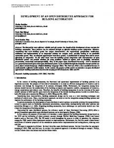
1. Aim Knowledge of benthic habitats plays a key role in the establishment of strategies for sustainable exploitation of marine resources (Botsford et al. 1997, Vallega 1999). Acoustic surveys have been widely used in seabed classification studies (Brown et al. 2002, Caddell 1998, Greenstreet et al. 1997, Legendre et al. 2002; Tuck et al. 1998), but a unified and standadized methodology has not been developed. Our aim is to develop an open protocol, using a combination of acoustic tools, statistical data analysis and groundtruthing for the identification, description and classification of marine benthic habitats. The output from this procedure will be used as input in a GIS, aiming for an efficient use in marine resource management.Acoustic waves produced by transducers travel through the water column producing a backscatter every time they reach a transition between two different acoustic impedance materials. These backscatter waves give us information on the water column. The impinging wave and the element or medium that produced the wave, characterize the backscatter. Two different frequency impinging waves will result in different backscatters, giving different information on various characteristics of the target. Due to the strength loss and transformation on the impinging wave once it has backscattered first on the bottom and then on the sea surface, the energy values from the bottom reflection will contain information on every element of the floor, while those from the surface reflection will consist just on information on the highest acoustic impedance elements of the bottom. Based on this rationale, a methodology for benthic habitat classification using a comparative analysis of the first echoes of two different frequencies, 38 kHz and 200 kHz, and the second and third echo at 38 kHz is being designed and applied to different field datasets. Field work was designed to be carried out with a minimum of infrastructure and logistics. 2. Field work Three acoustic surveys were done using an EA400P echo-sounder (Simrad, Norway). This is an hydrographic echo-sounder working simultaneously at 38 and 200 kHz. During the surveys, parameters were adjusted to enhance performance for future data analyses. Maximum ping rate and a pulse length of 1,024 milliseconds were set. The speed of the boat was 4 to 6 knots. Small fishing boats (7 to 10 meter long) were used. The transducer was mounted on the side using a portable device, at a depth of approximately 1 m. The surveys consisted of a series of transect grids, mostly perpendicular to the coastline, from depths of 15 to 150 m. Distance
between contiguous transects was set to 300-600 m, depending on maximum depth. Positions were recorded into the sounder files using a GPS signal input. Acoustic data were recorded in raw files that contained information on the echo-sounder settings, position and backscatter energy values of each ping. 3. Postprocessing Scientific echo-sounders record continuous backscatter signals from the sent ping through their transducers. These signals are discretized, integrating the energy values at certain known intervals (constant or variable, depending on the echo-sounder). Each energy value represents a portion of the sampled water column. These discrete data are stored in files (raw files) together with the settings used in the recording. Raw files are not the same but similar in a number of commercial echo-sounders, and thus a detailed knowledge of their structure is fundamental to both avoid dependence on commercial software as an intermediate step and to build a flexible methodology, transferable to different types of echo-sounders. For this reason, the first step in this project has been the programming of a software application to read the raw file and extract the data into matrixes. Firstly, the software uses the raw file(s) corresponding to each transect as an input, extracting energy values that need to be corrected using the sounder settings to obtain backscatter strength values per volume unit (Sv), in a similar way as other commercial software for viewing, quantifying or editing echo-sounder data. Secondly, it links geographic locations to each ping and selects the energy values corresponding to the bottom (direct backscatter and, in case it is available, the second, surface-reflected bottom) to present them in a matrix than can be exported to any statistical analysis package. Complementarily, the software extracts other two tables, the first one being a report containing the settings of the survey and any complementary data that the user may ask for. The second one is a bathymetry table containing georeferenced bottom depth values, allowing the user to easily create a bathymetric cartography using any GIS. 4. Statistical analysis of acoustical data and geographical coherence algorithm The energy value matrix is used as direct input for statistical analysis to identify, describe and classify benthic habitat types. Each one of the intervals selected from the raw file would be treated as a variable. The first step in the statistical procedure will consist of a reduction of the dimensionality of the matrix using principal component analysis. Once the new variables, principal components, are defined, grouping of acoustically similar observations will be performed using non-hierarchical cluster analysis. Data georeferenciation will allow for rapid mapping of the observations, already classified, and to analyze their geographic coherence. Statistical algorithms will be implemented to restrict the groupings obtained by the cluster algorithm to be spatially contiguous. 5. Data validation The data on acoustic variability of the surveyed grounds is described and classified through statistical analysis giving as result groups of locations with similar acoustic signatures. These results should be validated to corroborate that each acoustical bottom type corresponds to a similar type of habitat using environmental criteria and that different acoustical types represent different habitats. For this purpose, complimentary observations will be carried out at sampling points located along the transect using a combination of diving, remotely operated vehicles equipped with video and photographic systems and, for soft-bottoms, sediment characteristics obtained from corer samples. Samples will be stratified according to the acoustical groups obtained previously and other relevant variables as depth. Discrepancies between acoustic results and
2
groundtruthing will be analyzed to correct the habitat maps obtained. This procedure will be implemented in a GIS. The characteristics of each step of the procedure presented here allow the application of the same protocol, software and data analysis methods to other projects using different echosunders. Both a detailed description the field, postprocessing and statistical procedures and the original software will be available in publications and the Internet for easy use by other users.
HYDROACOUSTICS
CORERS
GRAB
SURVEY
POSTPROCESSING
ACOUSTIC CLASSIFICATION
FOTO & VIDEO SUB
GRANULOMETRY AND SEDIMENTOLOGY ANALYSIS
FEEDBACK: ACOUSTIC RESOLUTION LEVEL
HABITAT CLASSIFICATION
GROUNDTRUTHING
FISHING
BIOLOGICAL SAMPLINGS
COMMUNITY ANALYSIS
BIOTOPE CLASSIFICATION
COASTAL PROCESSES TROPHIC WEBS
DYNAMIC HABITAT DESCRIPTION
BIOLOGICAL PRODUCTION PATTERNS
6. Bibliography: • • • • • •
•
Botsford LW, JC Castilla, & CH Peterson (1997). The management of fisheries and marine ecosystems. Science 277:509-515. Brown CJ, KM Cooper, WJ Meadows, DS Limpenny & HL Rees (2002). Small-scale mapping of sea-bed assemblages in the eastern English Channel using sidescan sonar and remote sampling techniques. Estuar. Coast. Shef Sci. 54:263-278. Caddell SE (1998). Application of an acoustic sea floor classification system for benthic habitat assessment. J. Shell. Res. 17:1459-1461. Greenstreet SPR, ID Tuck, GN Grewar, E Armstrong, DG Reid &PJ Wright (1997). An assessment of the acoustic survey technique, RoxAnn, as a means of mapping seabed habitat. ICES J Mar Sci 54:939-959. Legendre, P., K.E. Ellingsen, E. Bjørnbom, & P. Casgrain (2002). Acoustic seabed classification: improved statistical method Can. J. Fish. Aquat. Sci. 59: 1085–1089 Tuck ID, SJHall, MR Robertson, E Armstrong & DJ Basford (1998). Effects of physical trawling distubance in a previously unfished sheltered Scottish sea loch. Mar Ecol Prog Ser 162:227-242. Vallega A (1999). Fundamentals of integrated coastal management. Dordrecht: Kluwer Academic Publishers.
3