Geomorphology, 223, 45â60. doi:10.1016/j.geomorph.2014.06.025. Barlow ..... Coe, J. A., Michael, J. A., Crovelli, R. A., Savage, W. Z., Laprade, W. T., ..... Gorsevski, P. V., Brown, M. K., Panter, K., Onasch, C. M., Simic, A., & Snyder, J. (2015).
Chapter 3: A Review of Landslide Mapping
3.0 Introduction The importance of landslide mapping cannot be underestimated given the enormous losses and damages incurred to the environment and the increasing vulnerable population. Landslide mapping may be motivated by any of the following reasons; landslide inventory, susceptibility assessment, hazard assessment/zonation mapping or risk evaluation and mitigation. Landslide inventory, distribution type of landslide map, is the simplest form of landslide map showing past and current landslides. Their significance is discussed in section 3.3. In contrast to inventories which focus on the past, hazard zonation, susceptibility maps, and risk evaluation maps are focussed into the future landslide occurrences with the aim of increasing awareness, preparedness and boosting mitigation (Hervás and Bobrowsky, 2009). Landslide susceptibility is defined by Guzzetti et al. (2005) as the probability of landslide occurrence/slope failures, given a set of geo-environmental predisposing factors. On the other hand, a landslide hazard goes beyond the landslide susceptibility and includes the spatial distribution (location), magnitude (volume, intensity, area) and the time frame when the landslide phenomenon is expected (Guzzetti et al., 1999). Landslide risk involves measuring the likelihood and severity of the adverse consequences caused by landslide to health, property or the environment (Ercanoglu, 2008). Thus, risk analysis should involve the elements of hazard, vulnerability, and exposure (Catani et al., 2005). According to Crozier and Glade (2010), landslide vulnerability is the expected degree of loss associated with a given level of landslide hazard intensity. Therefore, vulnerability assessment requires an understanding of the elements at risk (persons or property); their location relative to the landslide, exposure; and landslide characteristics (e.g. run out distance, volume, velocity, area) (Dai et al., 2002). This chapter aims to provide a review of landslide mapping methods, with the main focus being the importance of RS data in preparing landslides triggering and predisposing factors, source of inventory maps, use of GIS-based framework for landslide hazard assessment and modelling, and finally the contribution of this research to the existing gap. 3.1 Landslide Susceptibility Mapping Methods Landslides phenomena involve complex interrelations of various factors, and consequently no single method exists to adequately map, delineate landslide hazard and evaluate risk 18
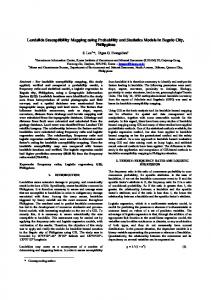
(Guzzetti, 2006). Instead, the choice of a landslide mapping technique is dependent on: the extent and complexity of the study area, the expertise/skills of the investigator, availability of up to date landslide inventory of the area of interest, and the available resources/data (Guzzetti et al., 2000). Generally, landslides are as a result of slope failure and thus it is assumed that they can be governed by mechanical laws using empirical, statistical or deterministic methods (Dietrich et al., 1995; Guzzetti et al., 1999). Predicting landslide occurrence and quantifying the impact are important aspects of landslide hazard assessment (Bovolo and Bathurst, 2012). The principal goal of landslide hazard assessment is to mitigate landslide hazards and the results are the production of hazard and risk maps. The analysis of the relationship between landslides and the spatial distribution of the factors initiating landslides enables landslide hazard assessment. Thus, landslide hazard assessment requires mapping and ranking of the various slope instability factors in order to assign a hazard index (Guzzetti et al., 1999). Various landslide mapping methods are reviewed and are mainly categorized into; qualitative versus quantitative, and direct versus indirect mapping methods (Aleotti and Chowdhury, 1999; Catani et al., 2005; Kanungo et al., 2009; Pardeshi et al., 2013). A GIS enables the management of spatial data and the assessment of qualitative and quantitative aspects of landslide hazard. Qualitative techniques are subjective in nature, in that they depend on the experts’ experience and knowledge to quantify the relative importance of various landslide causative thematic layers and hence the hazard maps are shown in descriptive terms. Quantitative methods are considered more objective ways of relating landslide spatial distribution to the landslide causative factors. They result in numerical estimates/probabilities of landslide occurrence in an area. Direct mapping methods depend to a large extent on the degree of hazard and are based on the experience of the geomorphological mapper. Indirect mapping methods involve stepwise landslide hazard assessment beginning with identification and mapping of training areas (provided by landslide inventory), followed by mapping of slope instability factors, and finally generating slope failure map, according to the degree of contribution of slope instability factors and the classification into hazard zones (Guzzetti et al., 1999). Figure 3.1 is a brief overview of the various landslide susceptibility/hazard assessment mapping methods.
19
Geomorphological field mapping
Direct
Combination or overlay of index maps
Heuristic Qualitative Indirect
Index based / parameter maps
-
Landslides mapping Methods
Quantitative / Indirect
Geotechnical/ Deterministic/ Physical
Logical analytical
SINMAP TRIGRS SLIDE SHETRAN SHALSTAB SLIP -
Bivariate
Statistical: Multivariate
-
Distribution free:
Multi-criteria Decision making (MCDM)
-
-
LAPSUS GQDM GeoTOP CHASM dSLAM etc
InfoVal LNSF WOE Frequency ratio Weighted overlay -
Probabilistic Approaches:
-
Discriminant Regression analysis: linear and logistic
Conditional probability, Favourability function Bayesian probability Certainty Factor Likelihood ratio
ANN Fuzzy set based Neuro-fuzzy SVM
Analytic Network Process Analytic Hierarchy Process Weighted Linear Combinations
Empirical/ Landslide threshold analysis
Figure 3.1: Chart showing landslide Susceptibility/hazard assessment methods (Source: modified from Aleotti and Chowdhury (1999)). 20
3.1.1 Geomorphological Field Method The method involves the direct mapping of landslides determined directly in the field by geomorphologist based on individual experience (Turner and Schuster, 1996). It is highly subjective given that there are no standard rules for the assessment (Kanungo et al., 2009). The investigator has to estimate the actual and potential slope failures based on the single particular events mapped in the field (Guzzetti et al., 1999). It is suited for single particular landslide events involving small areas as it is slow and expensive. Another challenge is mapping old landslides which is complicated by various reasons discussed in detail by Guzzetti et al. (2012), among them; vegetation regrowth, further land degradation processes dismantling the old scars, or difficulty establishing landslide boundaries. 3.1.2 Combination of Maps Index-based/ map combination approaches are indirect qualitative methods in which the expert’s knowledge is applied to rank and weight landslide causative factors according to the assumed or expected importance in contributing to landslides / mass movements. Thus, they are characterized by subjective priori weight assigned to each landslide factor, where weights vary from place to place, expert to expert and hence it is not possible to extrapolate a model developed for one area and apply to another. Soeters and Van Westen (1996) have summarised the map combination steps as follows: mapping of landslide predisposing factors; categorization of each thematic layer; weight assignment to each landslide predisposing thematic layer and category; integration of the thematic layers; and production of a landslide susceptibility zonation map. Recent trends by geomorphologists is the use of Geospatial technologies of RS and GIS in preparing the landslide causative thematic layers and then using their expert knowledge to assign weights in the integration of the thematic layers (Kanungo et al., 2009). 3.1.3 Heuristic Methods Heuristic approaches are indirect landslide mapping methods where the geomorphologists/ experts are trained to detect and classify landslides from imagery based on experience, and the analysis of landslide signature (Pike, 1988). This requires training and an interpretation criterion to aid identification of landslide morphological forms using texture, pattern, colour, tone, shape, size, and topography characteristics (Antonini et al., 2002). Interpretation of aerial photographs has been the most common data source for heuristic landslide mapping. This is due to their availability, high spatial resolution, and the stereo-view capability with additional vertical exaggeration, thereby amplifying landslide morphological/topographic 21
signature. Interpretation of multi-temporal aerial photographs can provide essential temporal and geographical evolution of slope failure and landslide processes in an area (Fiorucci et al., 2011; Guzzetti et al., 2005). Recent trends in heuristic/visual interpretation analysis involve use of high resolution orthorectified satellite images to detect and map landslides (e.g. Casagli et al., 2005; Gao and Maro, 2010; Marcelino et al., 2009; Weirich and Blesius, 2007). This presents an opportunity to map fresh landslides as well as provide complementary landslide information in areas where landslides leave clear marks. Also the use of very high resolution digital elevation models, DEMs (e.g. from Light Detection And Ranging, LiDAR) provides additional topographic and morphometric landslide characteristics by generating 3D-views in the form of hill-shaded relief, contour lines, and slope maps (Bajracharya and Bajracharya, 2008; Chi et al., 2008; Haeberlin et al., 2004; Mitasova et al., 2012; Nichol et al., 2006). Alternatively, the high-resolution DEMs from LiDAR data may be integrated with texture derived from satellite images, thus forming pseudo-stereoscopic images (Scaioni et al., 2014). Highresolution optical images such as QuickBird and IKONOS have also been used with success (e.g. Hervás et al., 2003). Other RS methods are discussed and reviewed later in section 3.3 greatly boost landslide interpretation and visualization. 3.1.4 Deterministic / Process- based Methods Deterministic models simulate the physical processes in which the slope responds to changes in ground water and rainfall, resulting in landslide initiation, subsequent slope failure and landslide occurrence. These are achieved through simple mechanical laws which evaluate stability analyses and generate a safety factor. Several methods exist for solving the safety factor, among them; infinite slope, Bishop, Janbu simplified, Morgenstein and price, Ordinary/Fellenius, Spencer, Janbu rigorous, Lowe-Karafiath, and generalised limit equilibrium method (Casagli et al., 2006). Each method has its own assumptions, hence inherent shortcomings. For example, the infinite slope model assumes that the plane of failure of the sliding mass is parallel to the ground surface. Thus, it is limited to predicting shallow landslides. Generally, the factor of safety (stability coefficient along the slip surface) is expressed as a ratio of the available shear strength (resisting force, τf ) to the shear stress (driving forces, τ) (Apip et al., 2010). Thus, slope failure occurs whenever the driving forces exceed the resisting forces (FOS < 1); FOS=1, indicates critical slope; and FS ˃1 indicates stable condition. Slope stability assessment can be calculated on the basis of static or dynamic conditions. Static conditions require the calculation of the factor of safety e.g. with a limit equilibrium stability 22
analysis, critical rainfall. Dynamic conditions consider the changing stability condition due to changing pore pressure and the process of saturation; the velocity of the sliding mass may also be calculated. The Mohr-Coulomb failure law (Shield, 1955) is used to express the shear strength in the infinite slope model, which can be modified according to saturated or unsaturated soil conditions. Examples of deterministic models include: Stability Index Map, SINMAP (Pack et al., 1998, 1999); Generalised Quasi Dynamic Model, GQDM (Tarolli et al., 2008); Dynamic Slope Stability Model, dSLAM (e.g. Chen and Lee, 2003); Landscape Process Modelling at Multidimensions and Scales, LAPSUS (Claessens et al., 2005, 2007); Shallow Landsliding Stability Mathematical Model, SHALSTAB (e.g. Listo and Carvalho, 2012; Montgomery and Dietrich, 1998); Transient Rainfall Infiltration and Grid-based Regional Slope Stability Model, TRIGRS (e.g. Baum et al., 2008; Liao et al., 2011; Vieira et al., 2010); Slope Infiltration Distributed Equilibrium, SLIDE (e.g. Liao et al., 2010); Shallow Landslide Instability Prediction, SLIP; GeoTOP (e.g. Rigon et al., 2006; Simoni et al., 2008); and CHASM (Anderson and Lloyd, 1991). Deterministic models are complex and data intensive due to large input parameters needed by the hydrology based landslide model, laboratory test and field measurements (Crosta and Frattini, 2003; Iverson, 2000; Montgomery and Dietrich, 1994; Van Westen et al., 2006). Thus, they are recommended for detailed landslide studies limited to local extent (e.g. RuizVillanueva et al., 2011). On the other hand, RS data and GIS environment can allow the models to be fed with distributed data, thereby increasing their utility to regional extents. Their added advantage is that they don’t require long-term landslide inventory data. Hence, unlike quantitative methods, deterministic approaches are applicable to areas with incomplete inventories (Kuriakose, 2010). Approaches in modelling and predicting rainfall induced triggered landslides have led to variations of physical models, incorporating stability models, hydrological models, static or dynamic conditions and probabilistic techniques in determining the factors contributing most to the hazard occurrence. This is to boost the understanding of the mechanisms involved, by allowing the simulation of pore pressure over time in the evaluation of slope stability. They enhance the estimates of landslide frequency and enable changes induced by land-use and climate variables to be obtained (Coe et al., 2004; Savage et al., 2003). This is because the coupled hydrological-stability models capture physical processes of rain infiltration, percolation in the unsaturated zone, evapotranspiration, and ground water recharge. Other 23
morphological and anthropogenic factors such as land-use may also be incorporated (Terlien, 1998). Hydrological models use water infiltration models to link surface and subsurface hydrology, saturated and unsaturated soil conditions. Infiltration is considered the most important parameter in controlling pore water pressure changes and uses models such as steady-state model (Montgomery and Dietrich, 1994), a transient “piston-flow” model (Salvucci and Entekhabi, 1994), transient diffuse model (Iverson, 2000), and Richard’s equation model (water and energy budgets e.g. Rigon et al., 2006). Infiltration models enable simulation of pore water pressure while taking into account recharge, seepage, and flow. Physically based models can also incorporate climate models as an input to assess changes in landslide activity. For example, research by Bathurst et al. (2005) used scenario runs on Hadley Centre GCM (HadRM3) for 2070-2099 in a SHETRAN physically based model and found reduced debris flow in a warmer drier climate. Tropical Rainfall Measuring Mission Multi-Satellite Precipication Analysis (TRMM TMPA) available at 0.25⁰ grid spatial and 3hourly resolution obtained cumulative rainfall of the 40 days prior the landslide event. Mercogliano et al. (2013) predicted landslides using High Resolution Slope Stability Simulator (HIRESS) model based on hydrological parameters and incorporated rainfall parameters from the GCM. Crozier (1997) emphasized the need for analysing trends in precipitation and evaluated the changes of landslide activity within the region of interest. Dikau and Schrott (1999) attributed the temporal slope instability changes to rainfall attributes (precipitation amount, frequency, duration) due to the changing climatic conditions. Their research recommended the use of hydrological factors (sudden change in permeability), mechanical factors, fissure flow and vegetation influence to be investigated in order to reconstruct a reliable landslide model reflecting the change in frequency due to changes in precipitation. 3.1.5 Statistical Methods Statistical methods are indirect and quantitative methods which aim at eliminating the subjectivity of the qualitative methods and instead compute weights using statistical techniques from landslide inventory data together with landslide predisposing factors (Aleotti and Chowdhury, 1999). The basis of landslide hazard assessments using statistical methods are landslide density distribution, and the magnitude and frequency analyses, which are computed from the landslide inventory (Crozier and Glade, 2010; Guzzetti et al., 2005). GIS technologies have proven quite useful in these studies due to the ability to analyse spatial 24
data, support statistical and mathematical modelling and simulation (e.g. Akgun, 2012; Neuhäuser et al., 2012; Yalcin et al., 2011). The bivariate statistical analysis calculates the weight of each landslide causative thematic factor layer based on landslide density, derived from landslide inventory layer. The landslide density values can be computed using the following common approaches; weight of evidence (WOE) using Bayesian probability model (e.g. van Westen et al., 2003), Information value (Info Val; e.g. Jade and Sarkar, 1993), landslide nominal risk factor (LNRF; e.g. Saha et al., 2005), frequency ratio analysis approach (e.g. Karim et al., 2011), and weighted overlay model (e.g. Sarkar et al., 1995). Multivariate statistical analyses are designed to consider the contribution of each landslide causative layer to the total landslide susceptibility (Kanungo et al., 2009) i.e. considers contributions from the relationships among the landslide causative factors, and the relationship between landslide distribution (inventory) and the landslide causative data (Pardeshi et al., 2013). Therefore, they overcome the limitations of the bivariate approaches which consider only the relationship between landslide distribution and the landslide predisposing factors. Examples of multivariate approaches are discriminant analysis (e.g. Carrara et al., 2003), regression analysis i.e. linear regression (e.g. Zhu and Huang, 2006), binary logistic regression (e.g. Ayalew and Yamagishi, 2005), and multiple logistic regression (MLR) (e.g. Mashari et al., 2012). Probabilistic approaches are a branch of statistical analysis which computes the probability of landslide occurrence given the spatial distribution of landslides and the landslide causative thematic layers (Kanungo et al., 2009). They compute the probability of landslide occurrence based on the spatial distribution, temporal, and size of landslide events (Guzzetti et al., 2005). They include: conditional probability model (e.g. Yilmaz, 2010), Bayesian probability model (e.g. Berti et al., 2012), Poison probability model (e.g. Guzzetti et al., 2005), certainty factor method under favorability function model (e.g. Kanungo et al., 2011), and likelihood ratio function (e.g. Lee and Min, 2001). Probabilistic approaches can also be applied within the deterministic models whereby the variability of geotechnical material parameters are considered to vary in magnitude with time (Aleotti and Chowdhury, 1999). This allows the probability density function to be computed, hence evaluate the probability of slope failure. 3.1.6 Distribution Free Approaches Distribution-free approaches are free from any distribution assumptions and they are designed to overcome the limitations of data dependent approaches (quantitative) which are highly 25
dependent on the reliability, quality, and nature of the data (Kanungo et al., 2009). They include approaches such as fuzzy logic, ANN, and combined neural-fuzzy models. Artificial neural networks uses artificial intelligence algorithms (i.e. mathematical methods derived from biological brain principles) to learn the behaviour of observations and extend the pattern recognition through modelling (Bhagat, 2006; Bishop, 1995; Krenker et al., 2011). ANN utilizing pattern recognition technique/clustering, essentially involves the efficient computation of the non-linear behaviour of multivariate dynamic systems without any priori assumption about data distribution. It takes into account the complex nature of landslide factors combinations and uncertainties in the landslide causative factors by computing the weights iteratively and keeping them hidden. ANN architectures allow weights adjustment correction based on the highest and training accuracies. Their resulting landslide susceptibility maps resemble the existing landslide field locations, thus in many studies they have reported satisfactory results and are recommended for landslide prediction (Arora et al., 2004; Ermini et al., 2005; Gómez and Kavzoglu, 2005; Pradhan and Lee, 2010b; Yilmaz, 2009). Another pattern recognition technique that has prediction ability like ANN, is the Support Vector machine (SVM; e.g. Peng et al., 2014). Fuzzy logic models are intelligent systems which can capture the judgement, induction or deduction in the form of linguistic variables known as fuzzy logical rules (Saboya et al., 2006). They use the fuzzy relations to approximate expert judgement as partly true or false, while fuzzy set ensures the membership values range between 0 and 1. Thus, the inferences are mathematical operators of intersection, union, and complements, which are implemented using logical operators such as AND, OR, NOT, XOR (Vahidnia et al., 2010). They are able to capture the interrelations among landslide predisposing factors as well as the factors contributing to slope failure. However, the interrelations are largely linear models and do not support dynamic and complex interrelations for determining landslide susceptibility. Fuzzy ratings can also apply weights, thereby enabling the ranking of landslide causative factors (e.g. Wang et al., 2009). In addition, they can be implemented as purely data-driven approaches using fuzzy relations, whereby fuzzy ratings are calculated based on the actual landslide spatial data distribution while considering the relativity of the different landslide causative layers (e.g. Ercanoglu and Gokceoglu, 2004). The Neuro-fuzzy model is an indirect quantitative landslide susceptibility method (using both data and expert’s knowledge), which employs fuzzy weightings to assign membership degrees to various landslide predisposing factors and the ANN is used to solve the regression and classification problem (Elias and Bandis, 2000; Kanungo et al., 2005). The ANN’s learning 26
capability is used to automate fuzzy system, hence developing a fuzzy inference system (FIS; Vahidnia et al., 2010). The FISs are flexible, non-linear models which enable judgement “reasoning” to be applied to the data. Various combinations of landslide causative thematic layers may be tested by adjusting the fuzzy membership values and their results validated using the landslide inventory data. This adaptive Neuro-fuzzy inference system (ANFIS) has been used with success, although the success of the predictive capability depends on the membership functions used in the fuzzy membership (Tien Bui et al., 2012). Consequently, it is recommended for regional landslide susceptibility mapping, where the model applies all the landslide causative thematic layers (Oh and Pradhan, 2011; Sezer et al., 2011). Another variation of combined Neuro-fuzzy model was implemented by Vahidnia et al. (2010) and it involved the stepwise mixing the quantitative and qualitative approaches. In the first step, the outputs from FIS were integrated into landslide depth intensity value. This was followed by training the neural network to solve the regression problem between landslide susceptibility and landslide predisposing factors. Lastly, the model was generalized to the entire study area. 3.1.7 Empirical Analysis Methods Empirical methods involve determining rainfall threshold values, beyond which, when exceeded, landslides are bound to be initiated (Reichenbach et al., 1998). Past landslide records together with rainfall characteristics of duration (D, in h) versus intensity (I, mm h -1) or event-cumulated rainfall (E, in mm) are used to a construct landslide triggering equation. An example of such an equation which relates duration and intensity is
, where:
α and β are parameters, c is a constant (Guzzetti et al., 2007b). The empirical computation involves studying past landslides and therefore assumes that a landslide event in the future occurs under similar triggering conditions (Guzzetti et al., 2007a). This requires detailed temporal landslide records to link meteorological data to landslide events, which in most cases are incomplete or missing (Coe et al., 2004). Empirical models based on a local scale (e.g. Vennari et al., 2014) perform better than regional (Guzzetti et al., 2007b; Reichenbach et al., 1998) and global scales (e.g. Caine, 1980) as other landslide predisposing factors differ with location (Sidle and Ochiai, 2006). Empirical models involving heavy-event rainfall parameters are better suited for predicting shallow landslide as oppose to deep-seated landslides which may incorporate seismic data. They can be used with rainfall radar data to predict landslide occurrence, although predicting the exact landslide location poses a challenge (Walker and Shiels, 2013). 27
Rainfall parameters involving intensity, duration, cumulative or antecedent rainfall are the most commonly used threshold parameters for rainfall-induced landslides. However, other thresholds could also be used, such as: critical pore water pressure, slope angle, reduction of shear strength or minimum displacement for landslides to occur (Reichenbach et al., 1998). Slope stability models could also be used with critical FOS boundaries defined, allowing the safety factor equation to be resolved backwards to derive the critical pore pressure. Empirical models could be improved by accounting other landslide predisposing factors such as soil geotechnical properties and soil moisture. For example, Ruiz-Villanueva et al. (2011) measured soil hydrological characteristics and incorporated them into a slope stability model “Generalized Quasi-Dynamic model” (GQDM) to estimate the critical rainfall intensity threshold which could be used as a predictive tool for areas prone to shallow landslides. Peres and Cancelliere (2014) combined rainfall and hydrological and slope stability physical model using Monte Carlo approach to simulate both triggering and non-triggering rainfall events, which were later analysed by receiver operating characteristics (ROC) curve to derive stochastic-input physically based thresholds. Empirical models have been criticised on the basis of failure to provide the actual physical process which trigger landslides i.e. no relationship between infiltration and rainstorm pattern (Tsai, 2007). Instead, landslide occurrences are related to values of rainfall amount greater than the minimum triggering rainfall duration threshold. However, they have been tested for real time landslide modelling with rainfall as the dynamic variable along with other landslide predisposing factors as static variables in logistic regression approaches (Takara et al., 2010). Another criticism is the lack of temporal component which is crucial for assessing landslide hazards under changing environmental conditions. Therefore, physical models which can model minimum triggering conditions and magnitude of landslides are recommended since they consider the spatial and temporal frequency of a landslide (Terlien et al., 1995). For example, Bovolo and Bathurst (2012) using a SHETRAN model showed that although the number of landslides increased with rainfall magnitude, rainfall frequency did not translate into landslide frequency. Their research showed the importance of the ability to quantify the triggering condition and the extent of landslide occurrence as a function of the rainfall return period, which increases the possibility of issuing warnings of landslide severity based on the weather forecast. 3.1.8 Multi-Criteria Decision Making (MCDM) Multi-criteria decision-making approaches are considered as semi-quantitative heuristic methods as they involve expert judgment to derive priority scales while using quantitative 28
approaches to determine the relative contribution of each landslide causative thematic layer (Pardeshi et al., 2013). They include: Analytic Network Process (ANP; Neaupane and Piantanakulchai, 2006), Analytic Hierarchy Process (AHP; Yalcin, 2008), and weighted linear combination models in GIS (Ayalew et al., 2004). Unlike heuristic approaches, they are effective for medium scale landslide susceptibility studies (Akgun, 2012; Ayalew and Yamagishi, 2005; Guzzetti et al., 1999). 3.2 Evaluation and Validation of Landslide Performance Model Landslide model quality evaluation may involve three aspects: accuracy, robustness (data sensitivity) or adequacy in describing the landslide process. Accuracy in predicting the observed data is rated as the most important evaluation parameter and it involves analysing the agreement between the model results and observed data (Frattini et al., 2010). The observed data is the landslide inventory, showing the presence or absence of landslides. Predicting the presence or absence of a landslide can be judged by the number of prediction errors; false positives or false negatives. The false negative (error type II / omission error) occurs when a landslide area is identified as stable, whereas the false positive (error type I/ commission error) occurs when stable area is identified as landslide area (Frattini et al., 2010). Some prediction errors may be traced to the data, and the chosen landslide model, thus the results of the model can be misleading (Fielding and Bell, 1997). Although the true positive rate and false positive rate can be used as performance evaluators (e.g. Brenning, 2005), they are insufficient as they ignore false negatives and false positives (Frattini et al., 2010). Instead, ROC curves which use both true positive rate and false positive rate are preferred. The greater the value of the area under the ROC curve (AUC), the better the model in predicting landslides accurately (Chung and Fabbri, 2003) and the similar the ROC curve is to a diagonal (trivial model), the higher the probability of landslide classification by chance (Frattini et al., 2010). At a perfect diagonal ROC line, the AUC is equivalent to 0.5, whereas high accuracy prediction values are achieved when the AUC approaches 1. On the other hand, Success-Rate (SR) curves are a graph of correctly classified landslide units (y axis), against the percentage area classified as unstable (x-axis) (Chung and Fabbri, 2003; Frattini et al., 2010). A Modified Success-Rate (MSR) was developed by Huang and Kao (2006) so as to avoid over and under prediction with the Success-Rate ratio/curve. The x-axis of the MSR is the total landslide sites in both actual landslide sites and in the stable cells. The economic consequences of landslide susceptibility maps are increased economic value for 29
misclassified stable areas and decreased economic value for landslide areas/unstable areas (Fielding and Bell, 1997). The costs of misclassification can be analysed with cost curves (Drummond and Holte, 2000). Other evaluation statistics are k-index (Landis and Koch, 1977), and cutoff dependent evaluation metrics criticized by Frattini et al. (2010) on the basis of splitting the cells/objects into stable or unstable susceptibility values, namely: Threat score, Gibert’s skill score, Pierce skill score, Heidke skill score and Yule’s Q. The Kappa statistic can also be used as it gives the measure of agreement between observed and predicted data, taking into account chance agreement with the prediction (Carletta, 1996). However, the Kappa statistic is criticized in landslide model evaluation as it gives inconsistent performance when landslide coverage changes (Huang and Kao, 2006). Remote sensing landslide inventory records can also be used for validation/landslide model calibration by using them as training data and performing back analysis (Scaioni et al., 2014). Also, comparing known landslide locations with a landslide susceptibility map to evaluate overlap areas, boundaries, or simple statistics such as area ratio or pixel fraction, can provide validation for geo-statistical landslide models (e.g. Lee, 2005). Monitoring slow moving landslides data from Interferometry Synthetic Aperture Radar (InSAR) techniques can also be used for calibrating landslide models in order to forecast landslide hazards (e.g. Bai et al., 2012). 3.3 The Role of Remote Sensing Data and Techniques in mapping Landslide Hazards Remote sensing datasets are a powerful data source for landslide visualization through heuristic approaches. For instance, optical aerial photography and its interpretation are the most suitable methods for benchmarking/validating landslide maps obtained through quantitative methods (Guzzetti et al., 2012). The role of RS in landslide studies is grouped into three categories: (i) recognition, detection and classification, (ii) monitoring, and (iii) forecasting, landslide susceptibility or hazard assessment (Mantovani et al., 1996; Metternicht et al., 2005; Qiao et al., 2013; Scaioni, 2013; Scaioni et al., 2014). These roles are closely interrelated as each role provides data for the proceeding step, i.e. monitoring requires accurate information on landslide locations, while landslide forecasting models require both landslide inventory and monitoring data. The following section describes in detail the roles of recognition, monitoring, and inventory mapping where RS is directly involved. Besides, RS provides essential thematic data which 30
are integrated within the GIS to process landslide susceptibility/hazard maps. Therefore, RS plays a critical role and its potential in landslide investigation has increased (Farina et al., 2005). This role is discussed independently in section 3.4. 3.3.1 Landslide Recognition, Detection and Classification with Remote Sensing Data The role of RS techniques in enabling automatic or semi-automatic recognition of landslide morphometric features has achieved a great milestone in landslide studies boosting both landslide monitoring and hazard assessment. However, the automated recognition is only possible by assuming that landslides often leave identifiable change in the morphology (morphological signature; dependent on the rate and type of movement), which can be mapped in the field or by RS methods (Cruden and Varnes, 1996; Dikau et al., 1996). Other identifiable changes at the surface or subsurface are land-use, geology, and lithology (Guzzetti, 2006). The automated recognition of landslide features has been facilitated by the availability of various data types (e.g. LiDAR, multispectral, very-high resolution optical or Synthetic Aperture Radar, SAR), digital image processing (DIP) which enhance visual interpretation, statistical analysis of landform topographic attributes (e.g. gradient, convexity, texture, curvature), standard signal processing (e.g. discrete Fourier transform, continuous wavelet transform), and feature extraction methodologies which facilitate classification (Guzzetti et al., 2012; Scaioni et al., 2014). While automation can be fully or semi automated, many proposed solutions are still more semi-automatic than fully automatic. The quality of the final products obtained through semi-automatic methods is dependent on the pre-/processing steps such as image registration, panchromatic (PAN)-sharpening, or ortho-rectification (Behling et al., 2014). 3.3.1.1 Towards Automatic or Semi-automatic Detection and Classification of Landslides Satellite imagery processing can lead to the automated landslide recognition and detection using methods such as index thresholding (Rosin and Hervás, 2005), image fusion enhancement methods (Marcelino et al., 2009), band ratios (Cheng et al., 2004), colour composites (Petley et al., 2002), texture image analysis (Whitworth et al., 2005), and filtering (Haeberlin et al., 2004). These DIP image enhancements lead to more accurate landslide recognition and classification utilizing semi-automatic classification algorithms (Mondini et al., 2011a). For example, Spectral Angle Mapper (SAM) supervised classification and Normalised Difference Vegetation Index (NDVI) thresholding reported higher accuracy
31
compared to parallelepiped, the minimum distance to mean, principal components (PCs), and multi-temporal image differencing in mapping landslides (Joyce et al., 2008a, 2008b). Landslide recognition based on pixel-based classification, automatic algorithms (supervised or unsupervised clustering (e.g. Borghuis et al., 2007)) and change detection techniques have been exploited in the past, although their major limitation is failure to consider neighbourhood information (Scaioni et al., 2014). Change detection by differencing pre- and post-landslide disaster spectral indices or processed image bands can map landslides and land-cover changes, although image pre-processing (radiometric and geometric correction) influences the quality of the results (Cheng et al., 2004). Multi-temporal change detection with vegetation index, followed by thresholding methods based on after event vegetation change analysis is a rapid pixel based landslide mapping method (Yang and Chen, 2010). For example, the NDVI method was used to detect fresh translation, mass movements of debris flows and earth flows (Chang and Liu, 2004; Schlögel et al., 2011; Zhao et al., 2012b). This method was successful in detecting both re(activation) of landslides and stabilizing slopes (marked by new vegetation), although Schlögel et al. (2011) noted that it is not suited for creating a landslide inventory. Mondini et al. (2011a) using a three change detection layer comprised of change in NDVI, independent and principal components, differentiated between stable areas and unstable areas (based on vegetation), and discriminated old and new landslides. The method also differentiated run-outs or sediment deposits from debris flows. Thresholding techniques may involve the use of band ratios or spectral indices (e.g. NDVI; (Liu et al., 2002), Normalised Difference Mid-InfraRed (NDMIDIR; Vohora and Donoghue, 2004)), since they depict changes in the land surface characteristics (land-cover, geology) due to geomorphic processes such as landslides. However, the landslide signature is not unique and they must be distinguished using other data, such as DEM morphology signatures (e.g. Borghuis et al., 2007). Vegetation indices are especially recommended for investigating deepseated landslides since they are covered by vegetation (Scaioni et al., 2014). Indices and band ratios also help solve the difference in illumination or shadowing problems in mountainous terrain areas. In addition, threshold values can be set to indicate where major or minor changes have occurred (e.g. Teng et al., 2008). To overcome the limitation of pixel based systems, the current trend is to utilise classification algorithms which allow integration of various data types, even allowing pseudo-stereoscopic images, e.g. objected-oriented image classification methods (Lang, 2008; Lu et al., 2011; Martha et al., 2010, 2012; Moine et al., 2009; Stumpf and Kerle, 2011), ANN classifier (e.g. 32
Brown, 2012; Gorsevski et al., 2015), and SVM (Marjanović et al., 2011). Such methods allow processed topographic signatures from DEM or texture data to be used in the classification of aerial photos or multispectral satellite imagery, thereby providing unique differentiation of landslides from other geomorphic land processes. Geomorphic feature extraction with high resolution DEMs are also explored for automatic landform detection, recognition and classification using topographic signatures, and processes such as segmentation, thresholding, and classification (Catani et al., 2005; Drăguţ and Blaschke, 2006; McKean and Roering, 2004; Passalacqua et al., 2014; Tarolli, 2014; Tarolli et al., 2012). The use of high resolution DEMs is particularly recommended since landslides involve geomorphic processes which are better captured using geomorphological indicators such as breaklines (Mann et al., 2012). 3.3.1.2 Landslide Detection with Remotely Sensed Data Landslide detection is largely dependent on the visual interpretation of satellite imagery of which optical data have provided more reliable results compared to SAR data (Joyce et al., 2009). This is attributed to higher spectral resolution and the sensor look angle provided by optical data, compared to SAR data which suffers extreme layover effects and shadowing in areas of high slope angle, where landslides and slope failures are prone (Zinck et al., 2001). For instance, the performance of IKONOS high resolution satellite imagery was rated equivalent or superior to ortho-photography in landslide mapping (Nichol and Wong, 2005a). The availability of high resolution satellite imagery, both PAN and multi-spectral scanner (MSS) has enabled detailed geological, topographic, and landslide mapping (e.g. De La Ville et al., 2002). For example, Schlögel et al. (2011) used QuickBird imagery to detect changes on the surface aided by the difference in morphological (texture) and spectral reflectance properties along discrete boundaries that result from landslide mass movement. Multispectral medium resolution satellite imagery (e.g. Landsat Thematic Mapper (TM) / enhanced Thematic Mapper plus (ETM+) / Operational Land Imager (OLI), SPOT series and Indian Remote Sensing satellite, IRS-1) is essential for mapping landslides in non-vegetated areas. However, advances in image enhancement techniques with multispectral imagery, have been explored for landslide applications, with vegetation stress indicators, image fusion with high resolution imagery, and geology enhancement DIPs being used to enhance landslide scars, since they are geo-hazard phenomena (Barlow et al., 2003; Li et al., 2013; Mondini et al., 2011b; Perez et al., 2006). Advanced Space-borne Thermal Emission and Reflection Radiometer (ASTER) enabled stereo capability facilitates mapping and assessment of volume changes and mass movements. 33
Analysis of high quality DEMs such as those provided by LiDAR data are important data source for the mapping landslide of various categories, namely: deep-seated landslides (Kasai et al., 2009), complex landslides (Corsini et al., 2009), rock slides (Oppikofer et al., 2009), rock falls (Royán et al., 2014), shallow landslides (Đomlija et al., 2014), and debris flows (Bull et al., 2010). However, the cost of LiDAR data has remained a limitation to landslide mapping. Instead, stereo viewing capability with IKONOS and QuickBird satellite sensors, which provide high-resolution DEMs are recommended (Joyce et al., 2009; Nichol et al., 2006). Another alternative source of elevation data is SAR sensors such as the German TanDEM-X mission availing global DEM at 12 m spatial resolution (Guzzetti et al., 2012). Thermal infrared data is an indicator of high hydro-geological risk, depicting land surface temperature at different slope parts, which in turn show the status of soil moisture and groundwater circulation (Bison et al., 1990). It also provides ground surface information which is not recognisable in the visible region (Whitworth et al., 2005). However, there is difficulty in obtaining high spatial resolution thermal data, which is expected to improve with the use of passive microwave RS data (Shi et al., 2012) or the availability of Sentinel 3 data (European Space Agency, 2015). Another challenge with temperature data in landslide investigation, is the fact that temperature data is a highly variable parameter; varying with changes in altitude, LULC, time of the day, climate, and topographic attributes of slope and aspect. 3.3.2 Landslide Monitoring Landslides monitoring entails tracking the failure process for regions prone to slope failures with time and updating landslide inventories with the measurements of ground deformation and surface point displacement (Sassa et al., 2009), which are very crucial for landslide hazard assessments (e.g. Farina et al., 2006; Righini et al., 2012). Other aspects that can be monitored for landslide triggering conditions are groundwater table level and geotechnical properties. RS techniques provide essential data for quantitatively measuring slope conditions using optical very high-resolution images, LiDAR or SAR data. Techniques that have been used successfully to measure horizontal displacement with repeated optical images are digital image correlation (e.g. Casson et al., 2003) and least squares matching (e.g. Debella-Gillo and Kääb, 2012). A 3D view is possible by projecting the 2D surface displacement using heights obtained from high-resolution DEM (Travelletti et al., 2012). Airborne laser scanning (ALS) allows topographic, and morphological analysis, and provides essential vegetation and underlying terrain data, including; surface roughness, slope, and 34
fractal dimensions (Razak, 2014). ALS forest foliage penetration power, independence to solar incidence, and ability to generate high-resolution Digital Terrain Model (DTM) has made it superior over passive optical and active radar sensors for mountainous terrain (Van Den Eeckhaut et al., 2007; Hodgson et al., 2003; Kraus, 2007). Therefore, ALS has opened new channels, facilitating landslide; detection, characterization, hazard assessment, modelling, and monitoring (Bitelli et al., 2004; Derron and Jaboyedoff, 2010; Jaboyedoff et al., 2012; Lin et al., 2013; Prokop and Panholzer, 2009; Rohrbaugh, 2015; Royán et al., 2014; Teza et al., 2007). The challenge with ALS data remains the high cost of acquisition, making it unavailable for large areas. This challenge can be overcome by utilizing elevation data obtained from SAR sensors, such as the German TanDEM-X mission availing global DEM at 12 m spatial resolution (Guzzetti et al., 2012). Multi-temporal analysis of the same area with LiDAR data are excellent sources of quantitative landslide volume estimates (Baldo et al., 2009; Passalacqua et al., 2014). Derivative products from LiDAR DEMs, facilitate not only visual analysis of the topographic surface, but also semi-automatic recognition of morphometric landslide features through feature extraction methodologies (e.g. Passalacqua et al., 2010; Tarolli et al., 2012). Visual analysis of LiDAR DEM has also enabled various landslide types to be mapped with success, i.e. deep-seated, shallow, debris flow, recent, old, under forested or in cultivated areas (Ardizzone et al., 2007; Chigira et al., 2004; Van Den Eeckhaut et al., 2007; Kasai et al., 2009; Razak et al., 2011). This is attributed to the high quality DEM provided by LiDAR as compared to InSAR DEM (Norheim et al., 2002). Laser scanning techniques suit monitoring applications, especially when integrated with other RS data for the characterization of steep slopes (Jaboyedoff et al., 2012). For example, Pesci et al. (2013) determined the velocity of surface displacements on the Italian volcano slopes by comparing multi-temporal terrestrial laser scanning data integrated with airborne photogrammetry. Similarly, the integration of terrestrial and ALS data from a study by Ghuffar et al. (2013), was successful in monitoring landslide displacement using 3D range flow algorithms on an active landslide slope in Austria. Synthetic aperture radar data provide textural and topographical data of the ground surface, since radar waves respond to both chemical and physical characteristic of the soil, hence making it important in the mineral, lithological, and geological exploration (Rawashdeh et al., 2006). In landslide investigation, radar interferometry has proved a good method for monitoring slow moving landslides, monitoring past-landslides deformation, as well as updating landslide inventory maps (Bardi et al., 2014; Cascini et al., 2010; Greif and Vlcko, 35
2012; Squarzoni et al., 2003; Del Ventisette et al., 2014). This entails measuring displacements, velocities or rate of displacement, mapping new landslide boundaries and the directions in which the landslides are moving towards (Czuchlewski et al., 2003; Hilley et al., 2004; Singhroy, 2013). Synthetic
aperture
radar
interferometry technique
enables
landslide
displacement
measurements by computing the interference pattern resulting from the phase difference of two SAR images of the same area (Yonezawa et al., 2012). Since the phase difference contains possible ground displacement among other contributions (e.g. terrain roughness, atmospheric effects, noise) in the line of sight, differential InSAR (DInSAR) have been utilised to model and extract displacement, while filtering out unwanted effects (Wasowski and Bovenga, 2014). Such unwanted effects resulting from temporal and geometric decorrelation decrease the quality of measured phase difference. Consequently, advanced DInSAR techniques (multi-temporal interferometry, MTI) aimed at improving the coherence of SAR images have been developed (Crosetto et al., 2005). The techniques include: Permanent/Persistent Scatterer (PSInSAR or PSI), and Small Baseline Subset (SBAS) which exploit long stacks of SAR images taken with similar sensor and under similar geometry (Wasowski and Bovenga, 2014). In the PSI technique, lack of coherence is overcome by identifying stable natural reflectors (coherent targets, called persistent scatterers, PS) such that displacement is detected as a measure of relative target velocity (multi-interferogram analysis of SAR images) along the line of sight (Lu et al., 2012). While the method can measure ground displacements to millimetre precision, it has the disadvantage in that some surfaces may not provide any coherent targets (e.g. deep slopes, vegetated areas; Scaioni, 2013). On the other hand, SBAS computes a spatial baseline displacement using the differential interferograms for multiple pairs of SAR images (Berardino et al., 2002). The resulting precision from SBAS is inferior to PSI, although it is suited for large area deformation monitoring (Guzzetti et al., 2009). Differential interferometry synthetic apertature radar ground displacements are useful for active landslide recognition, monitoring, and characterization of landslide deformations (e.g. Crosetto et al., 2011; Tantianuparp et al., 2013). The recognition entails characterizing debris material (Singhroy and Molch, 2004) and detecting new mass movements such as rotational and translational slides, rock slides (e.g. Lauknes et al., 2010), deep-seated landslides characterized by slow movements (e.g. Agliardi et al., 2009), landslide debris (Yonezawa et al., 2012) and flows. However, DInSAR encounters challenges due to foreshortening, layover effects, temporal decorrelation especially in vegetated areas and atmospheric propagation 36
effects (Rott and Nagler, 2006; Rott et al., 1999). Thus, InSAR data integration with in-situ sensors (e.g. GPS observations, field investigation) is recommended for providing validation and complementing data acquisition in regions lacking coherent targets (Akbarimehr et al., 2013; Strozzi et al., 2013). The current trend is the automation of monitoring landslides using semi-automatic and automatic detection of slow moving landslides. MTI techniques might present the optimal solution for monitoring since they have overcome the limitations of the traditional DInSAR systems which affect phase de-correlation, i.e. temporal decorrelation and atmospheric propagation effects (Hölbling et al., 2012; Tofani et al., 2013). For example, Lu et al. (2012) using a spatial statistical approach known as Persistent Scatterers Interferometry Hotspot and Cluster Analysis (PSI-HCA), developed an automatic procedure for recognising slow moving landslides. 3.3.3 Landslide Inventory Landslide inventory represents the simplest form of landslide map, provides information about where landslides are located and provide the basis for studying/predicting future landslides (Guzzetti, 2006). They are considered as the first step towards assessing landslide susceptibility (Guzzetti et al., 2012). In addition to landslide location, comprehensive landslide inventory provides topology, geometrical characteristics (e.g. primary direction of displacement), possible failure mechanism, date/frequency of occurrence, state of activity, possible causal factors, and damages incurred (Guzzetti et al., 2000; van Westen et al., 2008). Such information is useful for the analysis of landslide triggering factors as well as the derivation of frequency-magnitude relationships (Dai et al., 2002) using statistical models based on the past landslide occurrence (Guzzetti et al., 2005; Lee, 2005; Malamud et al., 2004). Landslide inventories provide the training areas necessary for landslide susceptibility mapping and enable validation testing of the landslide models. In the absence of the temporal aspect of landslide activity or rehabilitated landslide sites, numerical dating methods (e.g. dendrochronology1 ) followed by laboratory analyses can provide landslide age for updating a landslide inventory (e.g. Corominas and Moya, 2010; Dikau and Schrott, 1999; Van Den Eeckhaut et al., 2009). However, this is only limited to forested sloppy conditions. The inventory database can also have other attributes such as the type of movement, estimated age, activity, velocity, and depth (Guzzetti et al., 2004), which further determine 1
The science and technology of dating events, environmental change and archeological artifacts by using the characteristics patterns of growth rings in tree trunks. (Corominas and Moya, 2010)
37
categorization into shallow or deep landslides, aid landslide frequency analysis and susceptibility assessment. Field mapping methods provide detailed, high accurate landslide inventory maps, but are often slow and expensive, thus limited to small-scale areas (Santangelo et al., 2010). RS data sources, aided by semi-automated detection methods have provided alternative, efficient means to map recent and reactivated landslides (e.g. Borghuis et al., 2007; Tsai et al., 2010). The challenge with RS methods is that they cannot detect old or rehabilitated landslides. However, they offer alternative cheaper methods of updating landslide inventories (Ciampalini et al., 2015). Thus, stereoscopic aerial photo-interpretation provides detailed morphological landslide analysis, hence aerial photography has remained a valuable source of landslide inventory data (e.g. Fiorucci et al., 2011; Moine et al., 2009), which can be enriched further by the combination of aerial photographs with SAR satellite information (Cigna et al., 2010; Strozzi et al., 2013). However, aerial photos have been criticized for lack of repetitive coverage of similar area, thereby not suiting continuous landslide monitoring (Pardeshi et al., 2013). 3.4 The Role of Remote Sensing in Mapping Landslide Predisposing Factors Landslides are assumed to leave observable changes on the land surface, thereby modifying land cover and surface topography. Post and pre-landslide event RS imagery can be useful in studying and detecting landslide effects through landslide signature. However, Guzzetti et al. (2012) noted that landslide spectral signatures are not unique and instead, indicative terrain conditions should be used to infer landslide presence or absence. Such conditions are landslide predisposing factors and include: topography, geomorphology, geology, land-cover, hydrology, and anthropogenic factors (Corominas et al., 2013; van Westen et al., 2008). These factors interact with each other and a comprehensive landslide study should ideally consider their contribution. In practise, the chosen landslide model mechanism determines the relevance of the predisposing factors for landslide hazard/ susceptibility assessment (Corominas et al., 2013). 3.4.1 Contribution of Land-cover and Vegetation to Slope Stability Vegetation provides a protective barrier, thereby controlling wind and water erosion, while intercepting rainfall through the canopy. It also bears reinforcement properties enacted through changes in mechanical and hydrological properties that enhance slope stability (Stokes et al., 2008). Different plant types offer different levels of stability, but generally they support geotechnical hydrological mechanisms of evapotranspiration, interception, surcharge 38
root water uptake, and root reinforcement. Root moisture absorption and the loss of vegetation moisture through evapotranspiration prevent critical pore water pressure (which are responsible for triggering landslides) from being exceeded (Razak, 2014). Rainfall interception by vegetation leaves and stems reduce direct raindrops hitting the soil surface, thus controlling splash erosion and runoff. On the other hand, water drops quickly erode fine soil particles on the bare land surface, thereby creating voids which encourage more water ponding, hence increasing infiltration (Huat et al., 2006). The mechanical mechanism of vegetation, which is provided through roots reinforcement and anchoring, can have benefits (increase shear resistance) and adverse effects (increase shear stress) on slope stability (Greenway, 1987; Sidle and Ochiai, 2006). The root reinforcement increase soil shear strength, hence increasing slope stability (McIntosh et al., 2009). In addition, root water absorption and its loss to the atmosphere through evapotranspiration decreases soil moisture, which reduce the soil pore water pressure and consequently increase the soil strength. On the contrary, vegetation root network influence subsurface flow and tends to increase infiltration (Ghestem et al., 2011). For example, Crozier (2010) observed that infiltration rates were higher in the forested slopes than in partially covered vegetated areas. Besides, the trees’ weight loads increase the slope normal stress. The role of land-use and vegetation cover to rainfall induced landslides is such that, changes in vegetation cover often result in modified landslide behaviour (Glade, 2003). The author further noted that the first rainstorm following deforestation triggered landslide activity and resulted in higher sedimentation rates. Consequently, severe fire and deforestation on slopes can reactivate old or promote new landslides by reducing the root cohesion strength (Cannon et al., 2001; Wondzell and King, 2003). Kuriakose and van Beek (2010) stressed that root cohesion is one of the most important data necessary to assess the effects of anthropogenic disturbances on the probability of shallow landslide initiation. Their research found that root cohesion varies significantly with the type of land-use and depth of soil; hence, mixed crop land-use had the maximum root cohesion while fallow land, degraded forest, and young rubber plantation had the lowest root reinforcement. They also found that the bond between soils and root decreased when the soil was saturated. Thus, the applicable root reinforcement was limited by the root pullout strength. Forests or deep rooted vegetation help to stabilize the top soil, an important factor in reducing landslide hazard in steep areas (Perotto-Baldiviezo et al., 2004). Kuriakose et al. (2009) discussed the effects of deforestation/ land-use change on root reinforcement and the mitigating effect of tree canopy (through interception and evapotranspiration) in providing 39
surface protection, surcharge, and wind loading effects. Generally, root cohesion varies significantly with the type of land-use and the depth of soil and thus anthropogenic disturbances affect soil stability which then triggers landslides. Roering et al. (2003) observed that root strength can be predicted by mapping the distribution and characteristics of trees on potentially unstable slopes. Some physical landslide models have managed to capture root enforcement factor such as Wilkinson et al. (2002) who included the effect of vegetation and topography on slope stability using a combined hydrological slope stability model. Areas that have experienced landslides in the recent past are characterized by disturbed vegetation, which are recognizable from vegetation indices computed from hyper-spectral (e.g. Airborne Visible Infrared Imaging Spectrometer, AVIRIS) or multi-spectral data (e.g. Landsat TM/ETM+ and SPOT 4 or 5). Such indices reveal vegetation health status, type, vigour and can be utilised in landslide studies, such as: NDVI (Mondini et al., 2011b), NDMIDIR (Vohora and Donoghue, 2004), Normalized Difference Mid-Red (NDMIDR; Mwaniki et al., 2015a), Physiological Reflectance Index (PRI; Sims and Gamon, 2002), and Normalized Burn Index (NBI; Epting et al., 2005). On the other hand, land-cover maps can be prepared using classification techniques and suitable post accuracy assessment performed to validate the classification. Change detection is then applied using the classified imagery and areas revealing trends of deforestation or any form of land degradation noted. Miller (2013) provides a detailed review of the methods applicable for studying soil and vegetation with an aim of investigating landslides, land degradation, and slope failures. 3.4.2 Geology and Lithology Landslides are geo-hazards which are characterized by exposure of rock layers, shifts in soils and geological substrate. Fault, joint, cleavage, fissure, rock fracture or bedding plane present areas of geological discontinuities, which potentially indicate areas of rock property change such as orientation, roughness, permeability, or porosity (Singhal and Gupta, 2010). While these geological discontinuities may allow groundwater flow, they also control the type of slope failure such as: topples, planar, wedge, flow or circular failures (Agliardi et al., 2012). For example, highly fractured rocks with close joint spacing have low cohesion and result in circular or flow rock mass failure. On the other hand, the increase in dip orientation angle may result in toppling rock failure type. Geology attributes provide essential information relating to landslide activity such as: distance from the major tectonic shear zone and azimuth direction, rock type, and layering (rock profile) (Gupta and Joshi, 1990). Rock types influence the type and depth of slope materials, and determine how the slope responds to the external stresses. Besides, certain rock types are 40
more susceptible to landslides and slope failure than others. For instance, hard rocks such as igneous are resistant to erosion and form massive steep slopes (Anbalagan, 1992), while tertiary sedimentary rocks (e.g. schist, phyllites) are generally more susceptible to landslides in many parts of the world (Khazai and Sitar, 2004). In addition, Gerrard (1994) notes that specific failure types are associated with certain rock types and properties. On the other hand, the lithology and the degree of weathering of the underlying rock materials influence the rate of geomorphological processes such as landslides and erosion. Thus, the nature of rock discontinuities and extent of weathering influences the size and shape of the detached mass in the event of slope failure (Gerrard, 1994). Consequently, the presence of structural features (e.g. joints, faults, bedding planes) increases the susceptibility of a rock mass to rock falls, planar and block slides, and may influence deep-seated landslides in strong rock types (Gerrard, 1994; Moghaddas and Ghaforri, 2006). This is because weathering begins from the discontinuities causing rock exfoliation and disintegration. On the contrary, shallow landslides (mudflows, slumps, rotational failure) are more influenced by homogenous weathered mantle in weak rock types (Moghaddas and Ghaforri, 2006). Rock weathering reduces the strength and elasticity of the rock material, while increasing the porosity and saturation moisture content. The net effect on the rocks is decreased shear strength which may increase the susceptibility of landslides and slope failures (e.g. Regmi et al., 2013). However, rock weathering occurs in varying degrees within the rock profile, thereby creating potential failure planes. This is to a large extent determined by the rock type, which in turn influences the nature of material produced by weathering (Gerrard, 1994). Rate of weathering is dependent upon the climate, rock type, rock structure, topography, and time elements (Gerrard, 1994). Thus, in the tropical and subtropical areas, intense weathering in the hot and humid conditions produces thick weathered material, extending to a depth of 100 metres or more (e.g. Chigira et al., 2011). Consequently, the areas around the central highlands of Kenya (the Aberdares and Mt. Kenya region) have deep-weathered volcanic soils, emanating from weathered volcanic rocks, basalts and basaltic agglomerates (Davies and Nyambok, 1993). Besides, the rapid weathering of pyroclastic rocks overlying the stable basalts, produce clay soils (Ngecu and Ichang’i, 1999), which are generally more prone to mudflows and mudslides occurrence (Gerrard, 1994). On the other hand, specific rock types are comprised of certain minerals (joined together by chemical bonding, cementing or crystallisation) which decay under the processes of hydration, carbonation, hydrolysis, and oxidation. Consequently, rocks containing limestone are more readily chemically weathered 41
than granite rocks, while rocks bearing iron minerals are more susceptible to weathering through oxidation (Chigira and Kiho, 1994; Gerrard, 1994). Landslides are accompanied by mass movements which result in detached large blocks of rock mass. The initiation of landslide movement is associated with the following depth (profile) attributes (DeGraff, 1994): contact between soil and unweathered bedrock, contact of well-weathered and less-weathered soil, and base of the root zone. Therefore, geology rock layers determine the soil profile and are potential failure planes where permeability and density properties change (Walker and Shiels, 2013). On the other hand, the depth of developed soils greatly determines the volume of erodible material (Kuriakose et al., 2009). Geology factor also controls the landform elements of drainage patterns and intensity of dissection in an area. These factors may in turn influence slope stability directly (through increased infiltration) or indirectly through sub-aerial processes. Interesting studies are reported by Gerrard (1994) linking drainage basin parameters (e.g. channels) to rock strength and elasticity (function of rock type). Based on those reported studies, it was shown that ‘the more the channels and deeper the incision, the more rapid the removal occurs on low strength rocks, while the fewer the channels and shallower the incision, the less rapid the removal occurs on high strength rocks’. Remote sensing multispectral and hyper-spectral data are commonly being used to provide surface geology data (i.e. lithology, lineaments, tectonic structure). Hyper-spectral remotely sensed data is resourceful for geological mapping, enabling surface rock characterization (mineral or lithology) using spectral absorption band features (van der Meer et al., 2012). Hyper-spectral data also facilitates characterization of soils by type, moisture, and chemical properties, which can aid further extraction of geotechnical parameters for slope stability assessment. In addition, soil characteristics influence vegetation growth and hydromechanical responses of the slope to water infiltration and flow (Kuriakose et al., 2009). Several hyperspectral sensors are still expected to be launched in the near future (Ortenberg, 2016), but the utility of the data will greatly depend on the ability to process the highdimensional data, while integrating the spatial and spectral component (Goetz, 2009; Plaza et al., 2009). As regards landslide investigation with hyperspectral data, data reduction techniques (e.g. Principal Component Analysis; PCA, Independent Component Analysis; ICA) correlated to topographic attributes from DTM (Sterzai et al., 2010), ANN image classification (Rudd, 2005), and integration of hyperspectral and LiDAR data (Smailbegovic et al., 2011) have demonstrated great potential in slope instability studies. 42
Lineaments can be extracted from aerial photos using edge-enhancement and filtering techniques (Ayalew and Yamagishi, 2005), likewise using Landsat ETM+ imagery (Erener and Duezguen, 2008) or ASTER multispectral data (Hung et al., 2005). Further, the lineament density is used as an indicative measure of the rocks to fracturing, which is essential in landslide susceptibility studies (e.g. Atkinson and Massari, 1998; Pachauri and Pant, 1992; Pradhan et al., 2006). Various DIP with multispectral RS data including: False Colour Composites (FCC), PCA, ICA, Intensity Hue Saturation (IHS), band ratioing, Spectral Signature Analysis (SSA) and de-correlation stretch, have also been exploited with success in lithology discrimination, and structural geological visualization, as discussed by Mwaniki (2016), Mwaniki et al. (2015b) and the references therein. 3.4.3 Topographic/ Morphometric Properties GIS environments provide geo-processing computation of DEM raster data to obtain the topographic terrain attributes such as elevation, slope angle, aspect, and curvature. The slope angle is ranked the most important factor in landslide hazard analysis (Dai et al., 2002; Guzzetti et al., 1999) and its impacts are significant at both local and regional2 scales (Ayalew and Yamagishi, 2005). At the local scale, slope affects soil moisture and depth, upslope contributing area, pore water pressure, the speed of earth flow (the potential kinematic energy), the stream power index, and topographic wetness index which are important aspects of deterministic models. On steep slopes, most water runs as surface runoff with little infiltration, while gentle slopes encourage higher infiltration through the soil (Huat et al., 2006). Perotto-Baldiviezo et al. (2004) showed that slope and land-cover type characterize landslide occurrence, with landslide susceptibility increasing with increase in slope angle, particularly for water saturated soils. This is attributed to increased weight towards the slope toe, which increases the shear stress and thus contributes to reduced stability. On the other hand, aspect affects the rate of rock weathering by influencing the amount of sunshine and directional relief rainfall (Wieczorek et al., 1997), while the slope determines the ease of erodibility and energy of the weathering system (Robinson and Moses, 2011). Consequently, steeper slopes are associated with a dynamic weathering system compared to flat plains (Larsen, 2014; Robinson and Moses, 2011). This can be explained by the ease of erodibility (i.e. higher kinematic energy as water flows on steep rock surfaces) which exposes new rock surface layers to weathering. Curvature is a main topographic parameter affecting stability analysis and soil depth (Kuriakose et al., 2009). For example, Ohlmacher (2007) used
2
As used in hydrology i.e. local scale 1 m, regional scale 1 000 km (Bloeschl and Sivapalan, 1995)
43
curvature to evaluate areas prone to earth flow and slides in clay soils. It was found that areas with planar curvature were more prone to landslides compared to concave and convex curvature. Concave curvature (hollow areas) slowed the soil movement which increased stability within the hollow and towards the hill base. At the regional scale, topographic properties affect the hydraulic conditions that enable watershed delineation and drainage basins, while at the local scale they can be used to characterize landslide types. RS techniques have been used often to provide up-to-date, high resolution DEMs such as those afforded by airborne photogrammetry and LiDAR data. Alternative sources of DEMs are possible with stereo high-resolution optical data and InSAR techniques. 3.4.4 Geomorphology Geomorphological factors refer to distinguishable landforms in terms of mapping units and recent / past landslides. Mapping unit is thus a terrain subdivision which contains a set of ground conditions different from adjacent units and has defined boundaries (Carrara et al., 1995) i.e. maximises internal homogeneity within the units, while maximising heterogeneity among the units (Guzzetti, 2006; Guzzetti et al., 1999). The various terrain partitioning units for landslide susceptibility assessment and mapping are categorized into; grid cells, terrain units, unique condition units, slope units, geo-hydrological units, or topographic units (Van Den Eeckhaut et al., 2009; Guzzetti, 2006). The choice of the mapping unit affects the landslide model fit, ability to deal with uncertainties and consequently the reliability of the results obtained (Carrara et al., 2008; Guzzetti et al., 1999). Also important in the choice of the mapping unit is the spatial resolution of the RS data, especially for DEMs which are processed for terrain units. For example, while deterministic models with high spatial resolution DEM may process accurate locations of recent and past landslides and unstable areas using terrain units, geo-statistical approaches are sensitive to the number of cells in the model (Scaioni et al., 2014). 3.4.5 Hydrology Hydrological factors influence landslides and are critical elements contributing to soil shear strength in slope stability models. Such factors are groundwater table position, pore pressure changes, soil moisture, infiltration and permeability changes, lateral flow, soil saturation, and density of drainage networks. The higher the permeability /void ratio, the higher the hydraulic conductivity and consequently the higher the infiltration rate (Huat et al., 2006). Heavy infiltration can result in perched water tables when soil saturation point is reached and where 44
a permeable layer overlies an impermeable zone. This causes elevated pore water pressure, which drastically reduces the soil shear strength resulting in a reduced factor of safety and eventually soil slip/slope failure (Deb and El-Kadi, 2009). Subsurface water pressure responds to the rainfall amount (Baum and Reid, 1992), rainfall intensity and duration (Wilson, 2005), and rainfall seasonal patterns (Ellen et al., 1995). This is mainly dependent on soil permeability which determines rainfall infiltration, percolation, runoff, subsurface flow dynamics, and formation of perched water table; factors which directly affect the pore water pressure (e.g. Hinkelmann et al., 2011; Terlien, 1998). Landslide initiation is accelerated by a sharp rise in pore water pressure following net precipitation input (Kuriakose et al., 2009). For example, Huat et al. (2006) observed that the higher the rainfall intensity, the higher the infiltration rate, consequently lowering the slope factor of safety in high permeability soils. Similarly, Hamdhan and Schweiger (2011) showed that rainfall infiltration causes soil suction to decrease, hence lowering the FOS. However, in low permeable soils, long duration moderate rainfall intensity events may be responsible for slope failures (Casagli et al., 2006; Tofani et al., 2006). Therefore, changes in rainfall magnitudes, their timing and frequency can activate landslides of different magnitudes (Collison et al., 2000). A rising ground water table greatly increases the potential for landslide occurrence (Walker and Shiels, 2013). This is because changes in soil moisture balance lead to changes in pore pressure and are indicative of increasing mechanical load (van der Kamp and Schmidt, 1997). On the other hand, deep infiltration capillary barriers resulting from fine-grained soil overlying a more permeable soil surface layer (Mancarella et al., 2012) can condition the infiltration process, thereby accumulating water in the less permeable soil surface layer and consequently reduce stability through loss of soil suction (Galeandro et al., 2013). Rapid draw down of water can reduce soil stability, since the surfaces that were previously submerged, are left unsupported and with water-filled pore spaces (Walker and Shiels, 2013). This can cause an abnormal distribution of pore water pressure at the slope toe/river banks. Clay soils are especially more prone due to their water retention ability. These types of soil failure/ slump are likely to happen following receded floods, on river banks or river valley slope. Clay soil liquefaction can also occur at the slope toe or river channels, when the clay soil loses its shear strength and behaves like liquid causing damages in the case of huge events (Walker and Shiels, 2013).
45
Hydrology parameters influence slope stability and together with real-time rainfall data should be incorporated into landslide models. Combined hydrological and slope stability models make provision for studying the effects of soil moisture by simulation of groundwater recharge and pore water pressure changes as part of effective stress. However, the use of infinite slope assumptions in the deterministic models, limits the prediction of slope failures to shallow landslides (Chiang et al., 2012). In addition, they require detailed geotechnical soil properties at various soil depths, and ground water table; data which is not always easily available. It is recommended that future modelling requirements should consider aspects of groundwater and understanding of bedrock or perched water tables, groundwater flow, and back pressure from within the landslide boundary extending to the whole slopes where modelling slope stability is required (Brunsden, 1999). Remote sensing thermal infrared sensors and passive microwave can provide soil moisture data (Shi et al., 2012). For example, Younis and Iqbal (2015) showed that surface soil moisture estimated through the Temperature Vegetation Dryness Index (TVDI) adequately matched temporal variation of field soil moisture. Hence, it was recommended for evaluation of wet conditions. The author using Fourier Transform Infrared Technique (FTIR) analysis showed that as soil moisture increased, the soil reflectance decreased and vice versa. Other parameters that are indicative of soil moisture are; land-cover (Hong et al., 2007), use of Tasselled Cap Transformation (TCT) component (Vorovencii, 2007), soil water index (Brocca et al., 2012), spectral indices such as Normalised Soil Moisture index (NSMI), Water Index Soil (WISOIL) (Fabre et al., 2015). Drainage system and network may be computed in the GIS environment using a high resolution DEM, extracted and ordered from the flow accumulation parameter (e.g. Singh et al., 2014). 3.4.6 Anthropogenic Factors Human activities may have a negative impact on the environment and landscape, leading to land-use change, land degradation (deforestation, desertification) and climate change (Crozier and Glade, 2010). These impacts may accelerate landslide processes and other geomorphological hazards either directly or indirectly through i)
ground shaking or vibrations (i.e. reducing resistance forces);
ii)
increasing the slope’s load or weight (driving forces); and
iii)
modifying the slope substrate (Walker and Shiels, 2013).
46
Changes in slope self-load resulting from contribution of man-made infrastructure (buildings, artificial dams and reservoirs) are among the long-term landslide triggers (Hinkelmann et al., 2011). Construction of road cuts and tunnels, mine and quarry activities may involve rock drilling, blasting, and cutting which causes vibration similar to seismic waves from earthquakes. In addition, the vibration and blasting reduces the soil/rock resistance strength, whereas the cutting exposes geological layers to weathering processes. On the other hand, heavy traffic on transport network built on mountainous terrain, may cause vibration, increased load and risk of sedimentation (e.g. Sidle et al., 2014). Walker and Shiels (2013) argue that seepage from reservoirs, canals, culverts or septic tanks can cause increased infiltration, thereby increasing pore pressure and weight load on a slope. Such conditions increase the probability of landslides on a sloppy terrain. Similarly, pressure from urban development and the need to erect buildings, increases the weight load whereas the construction process modifies the soil profile and reduces slope strength. Anthropogenic land cover changes may affect geomorphic processes by reducing the strength of regolith material and climate variability, which increases the frequency of cyclonic storms and wind erosion (Glade, 2003). The human influence on the natural system by slashing, burning indigenous vegetation or deforestation can cause long-term change in vegetation and irreversible damage, thus significantly lowering the slope stability factor and triggering shallow landslides (e.g. Zêzere et al., 1999). For instance, the impacts of land-use (cattle stocking and pasturing) were found to increase landslides risk on mountainous environments where topography and climatic extremes are favourable for landslide occurrence (Meusburger and Alewell, 2008). Other anthropogenic agents interfering with slope settings include: intensive agriculture, population growth pressure, the need for economic development, and wild fire (Aleotti and Chowdhury, 1999; Cannon et al., 2001). 3.5 Landslide Triggering Factors: Rainfall Landslide triggering factors are earthquakes, heavy rainfall, glacier and snowmelt, and anthropogenic factors. Landslide predisposing factors are static, while the triggering factors introduce a temporal dimension (Dai et al., 2002). Rainfall induced landslides are increasingly more common in many parts of the world (Gariano et al., 2015), with increased climate variability altering precipitation pattern, thereby altering the distribution of heavy rain events and intensifying storms (Scaioni et al., 2014). Since precipitation is the main triggering factor of rainfall-induced landslides, some authors argue that rainfall prediction should be 47
considered as a landslide disposing factor because it is an event with probability of occurrence over time (Muthu et al., 2008). However, rainfall has a dynamic component and there is need to develop landslide hazard assessment models which can capture the dynamic rainfall patterns in order to predict rainfall induced landslides more accurately. Remote sensing offers the possibility to detect meteorological conditions at regional and global scales using rainfall radar data such as: Tropical Rainfall Measurement Mission (TRMM), Precipitation Radar, and Advanced Microwave Scanning Radiometer (AMSR). The use of radar in rainfall estimation is particularly useful for orographically induced extreme rainfall and floods. Advances in satellite based precipitation observation technology and availability of high resolution satellite products are facilitating the landslide real time prediction which were previously problematic owing to the scarcity of rain gauges (Chang et al., 2008; Takara et al., 2010). Indeed, radar rainfall maps have improved the spatial distribution of mapping rainfall and consequently the prediction of terrain stability (Chiang and Chang, 2009). Rain gauges provide direct rainfall measurement and provide validation for radar rainfall data, but their data lack accurate spatial-temporal pattern and requires dense-network of rain gauges which is not always available (Villarini et al., 2008). Therefore, rainfall radar data is preferred, although it requires validation with rain gauge data in order to improve estimated precipitation amounts (Corominas et al., 2013). Many deterministic models can incorporate rainfall data in the slope stability models, both as a dynamic variable (e.g. Hong et al., 2014; Iwahashi et al., 2012) or static rainfall estimates (Baum and Godt, 2010; Liao et al., 2012). 3.6 Specific Contribution of this Research to Landslide Studies Specific focus has been given to the role of RS in providing landslide predisposing data (geology, lineaments, land-use, vegetation cover, hydrology, and anthropogenic factors) and landslide triggering factors. In addition, the various landslide mapping techniques have been reviewed and it was noted that distribution free approaches (e.g. ANN, Neuro-fuzzy) are gaining more attention due to their ability to deal with complex interrelationships involved in landslide processes and causative factors. It has also been shown that rainfall-induced landslides need to incorporate land-use which is an indicator of environmental impact and captures vegetation cover and anthropogenic land-use (e.g. Canuti et al., 2004; Glade, 2003). Similarly, this research has investigated the role of changes in LULC and forms of land degradation in the study area as they influence landslides (Mwaniki and Moeller, 2015). 48
A special contribution of this research to landslide studies is the application of RS image enhancement methods to map geology (Mwaniki, 2016; Mwaniki et al., 2015b), NDMIDR spectral index capable of enhancing geological components and map landslides (Mwaniki et al., 2015a), and create landslide inventory (Mwaniki et al., 2015c). In addition, the incorporation of Sentinel-1 SAR-C data to enhance Landsat data through image fusion at feature extraction level, has greatly improved the landslide mapping, revealing fault lines and areas prone to deep-seated landslides (Mwaniki et al., 2016). The combined hydrological and slope stability model (CHASM) has also been slightly modified, to incorporate the parameters of vegetation cover, evapotranspiration, infiltration and the changes in pore water pressure were adapted from the GeoTOP model (Bertoldi et al., 2006; Rigon et al., 2006). Using this model and stepwise incorporation of rainfall parameters following a heavy rainfall event, it was possible to monitor the ground response given the changing pore pressure effects. In addition, the threshold rainfall values which are likely to trigger landslide events can be studied. The CHASM model provided a means to combine topography, geology, rock mass strength parameters, which were noted by Moore et al. (2009) as key controls on slope failures. This is described in detail in Chapter 7. References Agliardi, F., Crosta, G. B., Zanchi, A., & Ravazzi, C. (2009). Onset and timing of deep-seated gravitational slope deformations in the eastern Alps, Italy. Geomorphology, 103(1), 113–129. doi:10.1016/j.geomorph.2007.09.015 Agliardi, F., Crosta, G. B., & Frattini, P. (2012). Slow rock-slope deformation. In J. J. Clague & D. Stead (Eds.), Landslides: types, mechanisms, and modeling (pp. 208–221). Cambridge: Cambridge Univ. Press. Akbarimehr, M., Motagh, M., & Haghshenas, M. (2013). Slope Stability Assessment of the Sarcheshmeh Landslide, Northeast Iran, Investigated Using InSAR and GPS Observations. Remote Sensing, 5(8), 3681–3700. doi:10.3390/rs5083681 Akgun, A. (2012). A comparison of landslide susceptibility maps produced by logistic regression, multi-criteria decision, and likelihood ratio methods: a case study at İzmir, Turkey. Landslides, 9(1), 93–106. doi:10.1007/s10346-011-0283-7 Aleotti, P., & Chowdhury, R. (1999). Landslide hazard assessment: summary review and new perspectives. Bulletin of Engineering Geology and the Environment, 58(1), 21–44. doi:10.1007/s100640050066 Anbalagan, R. (1992). Landslide hazard evaluation and zonation mapping in mountainous terrain. Engineering Geology, 32(4), 269–277. doi:10.1016/0013-7952(92)90053-2 Anderson, M. G., & Lloyd, D. M. (1991). Using a Combined Slope Hydrology/Stability Model to develop cut slope design charts. ICE Proceedings, 91(4), 705–718. doi:10.1680/iicep.1991.17486 49
Antonini, G., Ardizzone, F., Cardinali, M., Galli, M., Guzzetti, F., & Reichenbach, P. (2002). Surface deposits and landslide inventory map of the area affected by the 1997 Umbria-Marche earthquakes. Bollettino Della Società Geologica Italiana, 121(1), 843–853. Apip, Takara, K., Yamashiki, Y., Sassa, K., Ibrahim, A. B., & Fukuoka, H. (2010). A distributed hydrological–geotechnical model using satellite-derived rainfall estimates for shallow landslide prediction system at a catchment scale. Landslides, 7(3), 237–258. doi:10.1007/s10346-010-0214-z Ardizzone, F., Cardinali, M., Galli, M., Guzzetti, F., & Reichenbach, P. (2007). Identification and mapping of recent rainfall-induced landslides using elevation data collected by airborne Lidar. Natural Hazards and Earth System Science, 7(6), 637–650. doi:10.5194/nhess-7-637-2007 Arora, M. K., Das Gupta, A. S., & Gupta, R. P. (2004). An artificial neural network approach for landslide hazard zonation in the Bhagirathi (Ganga) Valley, Himalayas. International Journal of Remote Sensing, 25(3), 559–572. doi:10.1080/0143116031000156819 Atkinson, P. M., & Massari, R. (1998). Generalised linear modelling of susceptibility to landsliding in the central Apennines, Italy. Computers & Geosciences, 24(4), 373–385. doi:10.1016/S00983004(97)00117-9 Ayalew, L., & Yamagishi, H. (2005). The application of GIS-based logistic regression for landslide susceptibility mapping in the Kakuda-Yahiko Mountains, Central Japan. Geomorphology, 65(1–2), 15–31. doi:10.1016/j.geomorph.2004.06.010 Ayalew, L., Yamagishi, H., & Ugawa, N. (2004). Landslide susceptibility mapping using GIS-based weighted linear combination, the case in Tsugawa area of Agano River, Niigata Prefecture, Japan. Landslides, 1(1), 73–81. doi:10.1007/s10346-003-0006-9 Bai, S. B., Wang, J., Zhang, Z., & Cheng, C. (2012). Combined landslide susceptibility mapping after Wenchuan earthquake at the Zhouqu segment in the Bailongjiang Basin, China. CATENA, 99, 18–25. doi:10.1016/j.catena.2012.06.012 Bajracharya, B., & Bajracharya, S. R. (2008). Landslide mapping of the Everest region using high resolution satellite images and 3D visualization. In Proceedings of the Mountain GIS e-conference (pp. 14–25). Kathmandu, Nepal. Baldo, M., Bicocchi, C., Chiocchini, U., Giordan, D., & Lollino, G. (2009). LIDAR monitoring of mass wasting processes: The Radicofani landslide, Province of Siena, Central Italy. Geomorphology, 105(3–4), 193–201. doi:10.1016/j.geomorph.2008.09.015 Bardi, F., Frodella, W., Ciampalini, A., Bianchini, S., Del Ventisette, C., Gigli, G., … Casagli, N. (2014). Integration between ground based and satellite SAR data in landslide mapping: The San Fratello case study. Geomorphology, 223, 45–60. doi:10.1016/j.geomorph.2014.06.025 Barlow, J., Martin, Y., & Franklin, S. E. (2003). Detecting translational landslide scars using segmentation of Landsat ETM+ and DEM data in the northern Cascade Mountains, British Columbia. Canadian Journal of Remote Sensing, 29(4), 510–517. doi:10.5589/m03-018 Bathurst, J. C., Moretti, G., El-Hames, A., Moaven-Hashemi, A., & Burton, A. (2005). Scenario modelling of basin-scale, shallow landslide sediment yield, Valsassina, Italian Southern Alps. Natural Hazards and Earth System Science, 5(2), 189–202. doi:10.5194/nhess-5-189-2005 Baum, R. L., & Godt, J. W. (2010). Early warning of rainfall-induced shallow landslides and debris flows in the USA. Landslides, 7(3), 259–272. doi:10.1007/s10346-009-0177-0 Baum, R. L., & Reid, M. E. (1992). Geology, hydrology and mechanics of the Alani-Paty landslide, Manoa Valley, Oahu, Hawaii (Open File Report) (pp. 92–501). U.S.: Geological Survey. 50
Baum, R. L., Savage, W. Z., & Godt, J. W. (2008). TRIGRS—A Fortran program for transient rainfall infiltration and grid-based regional slope-stability analysis, version 2.0 (Open File Report 2008-1159) (p. 75). U.S Geological Survey. Behling, R., Roessner, S., Kaufmann, H., & Kleinschmit, B. (2014). Automated spatiotemporal landslide mapping over large areas using rapideye time series data. Remote Sensing, 6(9), 8026–8055. doi:10.3390/rs6098026 Berardino, P., Fornaro, G., Lanari, R., & Sansosti, E. (2002). A new algorithm for surface deformation monitoring based on small baseline differential SAR interferograms. IEEE Transactions on Geoscience and Remote Sensing, 40(11), 2375–2383. doi:10.1109/TGRS.2002.803792 Berti, M., Martina, M. L. V., Franceschini, S., Pignone, S., Simoni, A., & Pizziolo, M. (2012). Probabilistic rainfall thresholds for landslide occurrence using a Bayesian approach. Journal of Geophysical Research, 117(F4). doi:10.1029/2012JF002367 Bertoldi, G., Rigon, R., & Over, T. M. (2006). Impact of Watershed Geomorphic Characteristics on the Energy and Water Budgets. Journal of Hydrometeorology, 7(3), 389–403. doi:10.1175/JHM500.1 Bhagat, P. (2006). Pattern recognition in industry (Reprinted). Amsterdam: Elsevier. Bishop, C. M. (1995). Neural networks for pattern recognition. Clarendon Press ; Oxford University Press. Bison, P., Grinzato, E., Pasuto, A., & Silvano, S. (1990). Thermal IR remote sensing in landslide survey. In Proceedings of the 6th International IAEG Congress (pp. 873–878). Balkema, Rotterdam, The Netherlands. Bitelli, G., Dubbini, M., & Zanutta, A. (2004). Terrestrial laser scanning and digital photogrammetry techniques to monitor landslide bodies. International Archives of Photogrammetry Remote Sensing and Spatial Information Sciences, 35(Part B 5), 246–251. Bloeschl, G., & Sivapalan, M. (1995). Scale Issues in Hydrological Modelling: A review. Hydrological Processes, 9, 251–290. Borghuis, A. M., Chang, K., & Lee, H. Y. (2007). Comparison between automated and manual mapping of typhoon‐triggered landslides from SPOT‐5 imagery. International Journal of Remote Sensing, 28(8), 1843–1856. doi:10.1080/01431160600935638 Bovolo, C. I., & Bathurst, J. C. (2012). Modelling catchment-scale shallow landslide occurrence and sediment yield as a function of rainfall return period. Hydrological Processes, 26(4), 579–596. doi:10.1002/hyp.8158 Brenning, A. (2005). Spatial prediction models for landslide hazards: review, comparison and evaluation. Natural Hazards and Earth System Science, 5(6), 853–862. doi:10.5194/nhess-5-853-2005 Brocca, L., Ponziani, F., Moramarco, T., Melone, F., Berni, N., & Wagner, W. (2012). Improving landslide forecasting using ASCAT-Derived soil moisture data: A case study of the torgiovannetto landslide in central Italy. Remote Sensing, 4(5), 1232–1244. doi:10.3390/rs4051232 Brown, K. M. (2012, December). Landslide detection and susceptibility mapping using Lidar and artificial neural network modeling: a case study in glacially dominated Cuyahoga river valley, Ohio (Masters thesis). Bowling Green State University, Ohio. Brunsden, D. (1999). Some geomorphological considerations for the future development of landslide models. Geomorphology, 30(1–2), 13–24. doi:10.1016/S0169-555X(99)00041-0 51
Bull, J. M., Miller, H., Gravley, D. M., Costello, D., Hikuroa, D. C. H., & Dix, J. K. (2010). Assessing debris flows using LIDAR differencing: 18 May 2005 Matata event, New Zealand. Geomorphology, 124(1–2), 75–84. doi:10.1016/j.geomorph.2010.08.011 Caine, N. (1980). The Rainfall Intensity: Duration Control of Shallow Landslides and Debris Flows. Physical Geography, 62(1/2), 23–27. doi:10.2307/520449 Cannon, S. H., Kirkham, R. M., & Parise, M. (2001). Wildfire-related debris-flow initiation processes, Storm King Mountain, Colorado. Geomorphology, 39(3–4), 171–188. doi:10.1016/S0169555X(00)00108-2 Canuti, P., Casagli, N., Ermini, L., Fanti, R., & Farina, P. (2004). Landslide activity as a geoindicator in Italy: significance and new perspectives from remote sensing. Environmental Geology, 45(7), 907– 919. doi:10.1007/s00254-003-0952-5 Carletta, J. (1996). Assessing agreement on classification tasks: the kappa statistic. In Computational Linguistics (Vol. 22, pp. 249–254). University of Edinburgh. Carrara, A., Cardinali, M., Guzzetti, F., & Reichenbach, P. (1995). GIS technology in mapping landslide hazard. In A. Carrara & F. Guzzetti (Eds.), Geographical Information Systems in Assessing Natural Hazards (pp. 135–176). Dordrecht, The Netherlands: Kluwer Academic Publishers. Carrara, A., Crosta, G., & Frattini, P. (2003). Geomorphological and historical data in assessing landslide hazard. Earth Surface Processes and Landforms, 28(10), 1125–1142. doi:10.1002/esp.545 Carrara, A., Crosta, G., & Frattini, P. (2008). Comparing models of debris-flow susceptibility in the alpine environment. Geomorphology, 94(3–4), 353–378. doi:10.1016/j.geomorph.2006.10.033 Casagli, N., Fanti, R., Nocentini, M., & Righini, G. (2005). Assessing the Capabilities of VHR Satellite Data for Debris Flow Mapping in the Machu Picchu Area (C101-1). In K. Sassa, H. Fukuoka, F. Wang, & G. Wang (Eds.), Landslides (pp. 61–70). Berlin/Heidelberg: Springer-Publishers. doi:10.1007/3-540-28680-2_6 Casagli, N., Dapporto, S., Ibsen, M. L., Tofani, V., & Vannocci, P. (2006). Analysis of the landslide triggering mechanism during the storm of 20th–21st November 2000, in Northern Tuscany. Landslides, 3(1), 13–21. doi:10.1007/s10346-005-0007-y Cascini, L., Fornaro, G., & Peduto, D. (2010). Advanced low- and full-resolution DInSAR map generation for slow-moving landslide analysis at different scales. Engineering Geology, 112(1–4), 29– 42. doi:10.1016/j.enggeo.2010.01.003 Casson, B., Baratoux, D., Delacourt, C., & Allemand, P. (2003). Seventeen years of the ‘La Clapière’ landslide evolution analysed from ortho-rectified aerrial photographs. Engineering Geology, 68(1–2), 123–139. doi:10.1016/S0013-7952(02)00201-6 Catani, F., Casagli, N., Ermini, L., Righini, G., & Menduni, G. (2005). Landslide hazard and risk mapping at catchment scale in the Arno River basin. Landslides, 2(4), 329–342. doi:10.1007/s10346005-0021-0 Chang, K.-T., & Liu, J. K. (2004). landslide features interpreted by neural network method using a high-resolution satellite image and digital topographic data. In Proceedings of ISPRS XX Congress, Commission VII TS WG VII/5 (pp. 574–579). Istanbul, Turkey. Chen, H., & Lee, C. F. (2003). A dynamic model for rainfall-induced landslides on natural slopes. Geomorphology, 51(4), 269–288. doi:10.1016/S0169-555X(02)00224-6
52
Chang, K., Chiang, S., & Lei, F. (2008). Analysing the Relationship Between Typhoon‐Triggered Landslides and Critical Rainfall Conditions. Earth Surface Processes and Landforms, 33(8), 1261– 1271. doi:10.1002/esp.1611 Cheng, K. S., Wei, C., & Chang, S. C. (2004). Locating landslides using multi-temporal satellite images. Advances in Space Research, 33(3), 296–301. doi:10.1016/S0273-1177(03)00471-X Chi, C., Liu, Z., & Zhang, J. (2008). Interpretation of landslide from SPOT-5 imageries in the Three Gorges Reservoir Area. In International Workshop on Earth Observation and Remote Sensing Applications, 2008 (pp. 1–5). Beijing: IEEE. doi:10.1109/EORSA.2008.4620291 Chiang, S.-H., Chang, K.-T., Mondini, A. C., Tsai, B.-W., & Chen, C.-Y. (2012). Simulation of eventbased landslides and debris flows at watershed level. Geomorphology, 138(1), 306–318. doi:10.1016/j.geomorph.2011.09.016 Chigira, M., & Kiho, K. (1994). Deep-seated rockslide-avalanches preceded by mass rock creep of sedimentary rocks in the Akaishi Mountains, central Japan. Engineering Geology, 38(3–4), 221–230. doi:10.1016/0013-7952(94)90039-6 Chigira, M., Duan, F., Yagi, H., & Furuya, T. (2004). Using an airborne laser scanner for the identification of shallow landslides and susceptibility assessment in an area of ignimbrite overlain by permeable pyroclastics. Landslides, 1(3), 203–209. doi:10.1007/s10346-004-0029-x Chigira, M., Mohamad, Z., Sian, L. C., & Komoo, I. (2011). Landslides in weathered granitic rocks in Japan and Malaysia. Bulletin of Geological Society of Malaysia, 57, 1–6. doi:10.7186/bgsm2011001 Chung, C.-J., & Fabbri, A. G. (2003). Validation of spatial prediction models for landslide hazard mapping, 30(3), 451–472. doi:10.1023/B:NHAZ.0000007172.62651.2b Ciampalini, A., Raspini, F., Bianchini, S., Frodella, W., Bardi, F., Lagomarsino, D., … Casagli, N. (2015). Remote sensing as tool for development of landslide databases: The case of the Messina Province (Italy) geodatabase. Geomorphology, 249, 103–118. doi:10.1016/j.geomorph.2015.01.029 Cigna, F., Bianchini, S., Righini, G., Proietti, C., & Casagli, N. (2010). Updating landslide inventory maps in mountain areas by means of Persistent Scatterer Interferometry (PSI) and photo-interpretation: Central Calabria (Italy) case study. In Mountain risks: bringing science to society (pp. 24–31). Claessens, L., Heuvelink, G. B. M., Schoorl, J. M., & Veldkamp, A. (2005). DEM resolution effects on shallow landslide hazard and soil redistribution modelling. Earth Surface Processes and Landforms, 30(4), 461–477. doi:10.1002/esp.1155 Claessens, L., Schoorl, J. M., & Veldkamp, A. (2007). Modelling the location of shallow landslides and their effects on landscape dynamics in large watersheds: An application for Northern New Zealand. Geomorphology, 87(1–2), 16–27. doi:10.1016/j.geomorph.2006.06.039 Coe, J. A., Michael, J. A., Crovelli, R. A., Savage, W. Z., Laprade, W. T., & Nashem, W. D. (2004). Probabilistic Assessment of Precipitation-Triggered Landslides Using Historical Records of Landslide Occurrence, Seattle, Washington. Environmental and Engineering Geoscience, 10(2), 103–122. doi:10.2113/10.2.103 Collison, A., Wade, S., Griffiths, J., & Dehn, M. (2000). Modelling the impact of predicted climate change on landslide frequency and magnitude in SE England. Engineering Geology, 55(3), 205–218. doi:10.1016/S0013-7952(99)00121-0 Corominas, J., & Moya, J. (2010). Contribution of dendrochronology to the determination of magnitude–frequency relationships for landslides. Geomorphology, 124(3–4), 137–149. doi:10.1016/j.geomorph.2010.09.001 53
Corominas, J., van Westen, C., Frattini, P., Cascini, L., Malet, J.-P., Fotopoulou, S., … Smith, J. T. (2013). Recommendations for the quantitative analysis of landslide risk. Bulletin of Engineering Geology and the Environment, 73, 209–263. doi:10.1007/s10064-013-0538-8 Corsini, A., Cervi, F., Daehne, A., & Ronchetti, F. (2009). Coupling geomorphic field observation and LIDAR derivatives to map complex landslides. In L. Borgatti, J.-P. Malet, & A. Remaitre (Eds.), Proceedings of the landslide processes conference (pp. 15–18). Strasbourg, France: CERG Editions. Crosetto, M., Crippa, B., & Biescas, E. (2005). Early detection and in-depth analysis of deformation phenomena by radar interferometry. Engineering Geology, 79(1–2), 81–91. doi:10.1016/j.enggeo.2004.10.016 Crosetto, M., Monserrat, O., Cuevas, M., & Crippa, B. (2011). Spaceborne Differential SAR Interferometry: Data Analysis Tools for Deformation Measurement. Remote Sensing, 3(12), 305–318. doi:10.3390/rs3020305 Crosta, G. B., & Frattini, P. (2003). Distributed modelling of shallow landslides triggered by intense rainfall. Natural Hazards and Earth System Science, 3(1/2), 81–93. doi:10.5194/nhess-3-81-2003 Crozier, M. J. (1997). The climate-landslide couple: a Southern Hemisphere perspective. In Rapid mass movement as a source of climatic eveidence for the Holocene (In: Matthews, J.A., Brunsden, D., Frenzel, B., Gla¨ser, B., Weiß, M.M., Vol. 19, pp. 333–354). Crozier, M. J. (2010). Deciphering the effect of climate change on landslide activity: A review. Geomorphology, 124(3–4), 260–267. doi:10.1016/j.geomorph.2010.04.009 Crozier, M. J., & Glade, T. (2010). Hazard assessment for risk analysis and risk management. In Geomorphological Hazards and Disaster Prevention (Alcántara-Ayala Irasema and Goudie Andrew, pp. 221–232). Cambridge University Press. Cruden, D. M., & Varnes, D. J. (1996). Landslide types and processes. In Landslide investigation and mitigation. Transportation research board, US National Research Council. Special Report 247 (Turner AK, Schuster RL, Vol. Chapter 3, pp. 36–75). Washington, D.C. Czuchlewski, K. R., Weissel, J. K., & Kim, Y. (2003). Polarimetric synthetic aperture radar study of the Tsaoling landslide generated by the 1999 Chi-Chi earthquake, Taiwan. Journal of Geophysical Research, 108(F1). doi:10.1029/2003JF000037 Dai, F. ., Lee, C. ., & Ngai, Y. . (2002). Landslide risk assessment and management: an overview. Engineering Geology, 64(1), 65–87. doi:10.1016/S0013-7952(01)00093-X Davies, T. C., & Nyambok, I. O. (1993). The Murang’a landslide, Kenya, 21(1), 19–21. doi:10.1007/BF00775046 De La Ville, N., Chumaceiro, D. A., & Ramirez, D. (2002). Remote Sensing and GIS Technologies as Tools to Support Sustainable Management of Areas Devastated by Landslides - Springer. Environment, Development and Sustainability, 4(2), 221–229. doi:10.1023/A:1020835932757 Deb, S. K., & El-Kadi, A. I. (2009). Susceptibility assessment of shallow landslides on Oahu, Hawaii, under extreme-rainfall events. Geomorphology, 108(3–4), 219–233. doi:10.1016/j.geomorph.2009.01.009 Debella-Gillo, M., & Kääb, A. (2012). Measurement of surface displacement and deformation of mass movements using Least Squares Matching of repeat high resolution and aerial images. Remote Sensing, 4, 43–67. doi:10.3390/rs4010043
54
DeGraff, J. V. (1994). The geomorphology of some debris flows in the southern Sierra Nevada, California. Geomorphology, 10(1–4), 231–252. doi:10.1016/0169-555X(94)90019-1 Del Ventisette, C., Righini, G., Moretti, S., & Casagli, N. (2014). Multitemporal landslides inventory map updating using spaceborne SAR analysis. International Journal of Applied Earth Observation and Geoinformation, 30, 238–246. doi:10.1016/j.jag.2014.02.008 Derron, M.-H., & Jaboyedoff, M. (2010). Preface ‘LIDAR and DEM techniques for landslides monitoring and characterization’. Natural Hazards and Earth System Science, 10(9), 1877–1879. doi:10.5194/nhess-10-1877-2010 Dietrich, W. E., Reiss, R., Hsu, M.-L., & Montgomery, D. R. (1995). A process-based model for colluvial soil depth and shallow landsliding using digital elevation data. Hydrological Processes, 9(3– 4), 383–400. doi:10.1002/hyp.3360090311 Dikau, R., & Schrott, L. (1999). The temporal stability and activity of landslides in Europe with respect to climatic change _TESLEC/ : main objectives and results. Geomorphology, 30. Dikau, R., Brunsden, D., Schrott, L., & Ibsen, M. L. (1996). Landslide recognition. Identification, movement and causes. England: John Wiley & Sons, Ltd. Đomlija, P., Bernat, S., Arbanas Mihalić, S., & Benac, Č. (2014). Landslide Inventory in the Area of Dubračina River Basin (Croatia). In K. Sassa, P. Canuti, & Y. Yin (Eds.), Landslide Science for a Safer Geoenvironment (pp. 837–842). Cham: Springer International Publishing. doi:10.1007/978-3319-05050-8_129 Drummond, C., & Holte, R. C. (2000). Explicitly representing expected cost: an alternative to ROC representation (pp. 198–207). ACM Press. doi:10.1145/347090.347126 Elias, P. B., & Bandis, S. C. (2000). Neurafuzzy systems in landslide hazard assessment. In Proceeding of the 4th International Symposium in Spatial Accuracy Assessment in Natural Resources and Environmental Sciences (pp. 199–2002). Ellen, S. D., Liu, L. S. M., Fleming, R. W., Reid, M. E., & Johnsson, M. J. (1995). Relation of slowmoving landslides on earth materials and other factors in valleys of the Honolulu District of Oahu, Hawaii (Open File Report) (pp. 95–218). U.S.: Geological Survey. Epting, J., Verbyla, D., & Sorbel, B. (2005). Evaluation of remotely sensed indices for assessing burn severity in interior Alaska using Landsat TM and ETM+. Remote Sensing of Environment, 96(3–4), 328–339. doi:10.1016/j.rse.2005.03.002 Ercanoglu, M. (2008). An overview on the Landslide susceptibility assessment Techniques. In Environment and geoscience proceedings of the 1st WSEAS international conference on environmental and geological science and engineering (EG’08) (pp. 131–134). Malta: WSEAS (Organization). Ercanoglu, M., & Gokceoglu, C. (2004). Use of fuzzy relations to produce landslide susceptibility map of a landslide prone area (West Black Sea Region, Turkey). Engineering Geology, 75(3–4), 229–250. doi:10.1016/j.enggeo.2004.06.001 Erener, A., & Duezguen, H. S. B. (2008). Analysis of landslide hazard mapping methods: Regression models versus weight rating. International Archives of Photogrammetry Remote Sensing and Spatial Information Sciences, 37/B8, 1682–1750. Ermini, L., Catani, F., & Casagli, N. (2005). Artificial Neural Networks applied to landslide susceptibility assessment. Geomorphology, 66(1–4), 327–343. doi:10.1016/j.geomorph.2004.09.025 55
European Space Agency. (2015). Copernicus, ESA’s Sentinel Satellites: Sentinel-3. Retrieved from http://www.esa.int/Our_Activities/Observing_the_Earth/Copernicus/Sentinel-3 Fabre, S., Briottet, X., & Lesaignoux, A. (2015). Estimation of Soil Moisture Content from the Spectral Reflectance of Bare Soils in the 0.4–2.5 µm Domain. Sensors, 15(2), 3262–3281. doi:10.3390/s150203262 Farina, P., Catani, F., Colombo, D., Fumagalli, A., Kukavicic, M., Marks, F., & Moretti, S. (2005). Remote sensing: a tool for landslide investigations at a basin scale. In Geophysical Research Abstracts (Vol. 7, pp. 10157–10168). European Geoscinces Union. Farina, P., Colombo, D., Fumagalli, A., Marks, F., & Moretti, S. (2006). Permanent Scatterers for landslide investigations: outcomes from the ESA-SLAM project. Engineering Geology, 88(3–4), 200– 217. doi:10.1016/j.enggeo.2006.09.007 Fielding, A. H., & Bell, J. F. (1997). A review of methods for the assessment of prediction errors in conservation presence/absence models. Environmental Conservation, 24(1), 38–49. Fiorucci, F., Cardinali, M., Carlà, R., Rossi, M., Mondini, A. C., Santurri, L., … Guzzetti, F. (2011). Seasonal landslide mapping and estimation of landslide mobilization rates using aerial and satellite images. Geomorphology, 129(1–2), 59–70. doi:10.1016/j.geomorph.2011.01.013 Frattini, P., Crosta, G., & Carrara, A. (2010). Techniques for evaluating the performance of landslide susceptibility models. Engineering Geology, 111(1–4), 62–72. doi:10.1016/j.enggeo.2009.12.004 Galeandro, A., Šimůnek, J., & Simeone, V. (2013). Analysis of rainfall infiltration effects on the stability of pyroclastic soil veneer affected by vertical drying shrinkage fractures. Bulletin of Engineering Geology and the Environment, 72(3–4), 447–455. doi:10.1007/s10064-013-0492-5 Gao, J., & Maro, J. (2010). Topographic controls on evolution of shallow landslides in pastoral Wairarapa, New Zealand, 1979–2003. Geomorphology, 114(3), 373–381. doi:10.1016/j.geomorph.2009.08.002 Gariano, S. L., Petrucci, O., & Guzzetti, F. (2015). Changes in the occurrence of rainfall-induced landslides in Calabria, southern Italy, in the 20th century. Natural Hazards and Earth System Science, 15(10), 2313–2330. doi:10.5194/nhess-15-2313-2015 Gerrard, J. (1994). The landslide hazard in the Himalayas: geological control and human action. Geomorphology, 10(1–4), 221–230. doi:10.1016/0169-555X(94)90018-3 Ghestem, M., Sidle, R. C., & Stokes, A. (2011). The Influence of Plant Root Systems on Subsurface Flow: Implications for Slope Stability. BioScience, 61(11), 869–879. doi:10.1525/bio.2011.61.11.6 Ghuffar, S., Székely, B., Roncat, A., & Pfeifer, N. (2013). Landslide Displacement Monitoring Using 3D Range Flow on Airborne and Terrestrial LiDAR Data. Remote Sensing, 5(6), 2720–2745. doi:10.3390/rs5062720 Glade, T. (2003). Landslide occurrence as a response to land use change: a review of evidence from New Zealand. CATENA, 51(3–4), 297–314. doi:10.1016/S0341-8162(02)00170-4 Goetz, A. F. H. (2009). Three decades of hyperspectral remote sensing of the Earth: A personal view. Remote Sensing of Environment, 113, S5–S16. doi:10.1016/j.rse.2007.12.014 Gómez, H., & Kavzoglu, T. (2005). Assessment of shallow landslide susceptibility using artificial neural networks in Jabonosa River Basin, Venezuela. Engineering Geology, 78(1–2), 11–27. doi:10.1016/j.enggeo.2004.10.004
56
Gorsevski, P. V., Brown, M. K., Panter, K., Onasch, C. M., Simic, A., & Snyder, J. (2015). Landslide detection and susceptibility mapping using LiDAR and an artificial neural network approach: a case study in the Cuyahoga Valley National Park, Ohio. Landslides. doi:10.1007/s10346-015-0587-0 Greenway, D. R. (1987). Vegetation and slope stability. In Slope Stability (M.G. Anderson, K.S. Richards, pp. 187–230). UK: Wiley, Chichester. Greif, V., & Vlcko, J. (2012). Monitoring of post-failure landslide deformation by the PS-InSAR technique at Lubietova in Central Slovakia. Environmental Earth Sciences, 66(6), 1585–1595. doi:10.1007/s12665-011-0951-x Gupta, R. P., & Joshi, B. C. (1990). Landslide hazard zoning using the GIS approach—A case study from the Ramganga catchment, Himalayas. Engineering Geology, 28(1–2), 119–131. doi:10.1016/0013-7952(90)90037-2 Guzzetti, F. (2006). Landslide hazard and risk assessment (PhD Thesis). Rheinischen FriedrichWilhelms University of Bonn, Faculty of Mathematics and Natural Sciences, Bonn, Germany. Guzzetti, F., Carrara, A., Cardinali, M., & Reichenbach, P. (1999). Landslide hazard evaluation: a review of current techniques and their application in a multi-scale study, Central Italy. Geomorphology, 31(1–4), 181–216. doi:10.1016/S0169-555X(99)00078-1 Guzzetti, F., Cardinali, M., Reichenbach, P., & Carrara, A. (2000). Comparing Landslide Maps: A Case Study in the Upper Tiber River Basin, Central Italy. Environmental Management, 25(3), 247– 263. doi:10.1007/s002679910020 Guzzetti, F., Cardinali, M., Reichenbach, P., Cipolla, F., Sebastiani, C., Galli, M., & Salvati, P. (2004). Landslides triggered by the 23 November 2000 rainfall event in the Imperia Province, Western Liguria, Italy. Engineering Geology, 73(3–4), 229–245. doi:10.1016/j.enggeo.2004.01.006 Guzzetti, F., Reichenbach, P., Cardinali, M., Galli, M., & Ardizzone, F. (2005). Probabilistic landslide hazard assessment at the basin scale. Geomorphology, 72(1–4), 272–299. doi:10.1016/j.geomorph.2005.06.002 Guzzetti, F., Peruccacci, S., Rossi, M., & Stark, C. P. (2007a). Rainfall thresholds for the initiation of landslides in central and southern Europe. Meteorology and Atmospheric Physics, 98(3–4), 239–267. doi:10.1007/s00703-007-0262-7 Guzzetti, F., Peruccacci, S., Rossi, M., & Stark, C. P. (2007b). The rainfall intensity–duration control of shallow landslides and debris flows: an update. Landslides, 5(1), 3–17. doi:10.1007/s10346-0070112-1 Guzzetti, F., Manunta, M., Ardizzone, F., Pepe, A., Cardinali, M., Zeni, G., … Lanari, R. (2009). Analysis of Ground Deformation Detected Using the SBAS-DInSAR Technique in Umbria, Central Italy. Pure and Applied Geophysics, 166(8–9), 1425–1459. doi:10.1007/s00024-009-0491-4 Guzzetti, F., Mondini, A. C., Cardinali, M., Fiorucci, F., Santangelo, M., & Chang, K.-T. (2012). Landslide inventory maps: New tools for an old problem. Earth-Science Reviews, 112(1–2), 42–66. doi:10.1016/j.earscirev.2012.02.001 Haeberlin, Y., Turberg, P., Retiere, A., & Senegas, O. (2004). Validation of Spot-5 satellite imagery for geological hazard identification and risk assessment for landslides, mud and debris flows in Matagalpa, Nicaragua. International Archives of Photogrammetry Remote Sensing and Spatial Information Sciences, 35, B1.
57
Hamdhan, I. N., & Schweiger, H. F. (2011). Slope Stability Analysis of Unsaturated Soil with Fully Coupled Flow-Deformation Analysis. Mathematical Geosciences at the Crossroads of Theory and Practice, IAMG 2011. doi:10.5242/iamg.2011.0063 Hervás, J., & Bobrowsky, P. (2009). Mapping: Inventories, Susceptibility, Hazard and Risk. In K. Sassa & P. Canuti (Eds.), Landslides – Disaster Risk Reduction (Vol. 19, pp. 321–349). Berlin, Heidelberg: Springer Berlin Heidelberg. doi:10.1007/978-3-540-69970-5_19 Hervás, J., Barredo, J. I., Rosin, P. L., Pasuto, A., Mantovani, F., & Silvano, S. (2003). Monitoring landslides from optical remotely sensed imagery: the case history of Tessina landslide, Italy. Geomorphology, 54(1–2), 63–75. doi:10.1016/S0169-555X(03)00056-4 Hilley, G. E., Bürgmann, R., Ferretti, A., Novali, F., & Rocca, F. (2004). Dynamics of Slow-Moving Landslides from Permanent Scatterer Analysis. Science, 304(5679), 1952–1955. doi:10.1126/science.1098821 Hinkelmann, R., Zehe, E., Ehlers, W., & Joswig, M. (2011). Special Section on Landslides: Setting the Scene and Outline of Contributing Studies. Vadose Zone Journal, 10(2), 473. doi:10.2136/vzj2011.0032 Hodgson, M. E., Jensen, J. R., Tullis, J. A., Riordan, K. D., & Archer, C. M. (2003). Synergistic Use of Lidar and Color Aerial Photography for Mapping Urban Parcel Imperviousness. Photogrammetric Engineering & Remote Sensing, 69(9), 973–980. doi:10.14358/PERS.69.9.973 Hölbling, D., Füreder, P., Antolini, F., Cigna, F., Casagli, N., & Lang, S. (2012). A Semi-Automated Object-Based Approach for Landslide Detection Validated by Persistent Scatterer Interferometry Measures and Landslide Inventories. Remote Sensing, 4(12), 1310–1336. doi:10.3390/rs4051310 Hong, Y., Adler, R. F., & Huffman, G. J. (2007). Use of satellite remote sensing data in the mapping of global landslide susceptibility. Natural Hazards, 43(2), 245–256. doi:10.1007/s11069-006-9104-z Hong, Y., He, X., Cerato, A., Zhang, K., Hong, Z., & Liao, Z. (2014). Predictability of a physicallybased model for rainfall-induced shallow landslides: Model development and case studies. In M. Scaioni (Ed.), Modern Technologies for Landslide Investigation and prediction. Berlin, Germany: Springer. doi:10.1007/978-3-662-45931-7_9 Huang, J. C., & Kao, S. J. (2006). Optimal estimator for assessing landslide model performance. Hydrology and Earth System Sciences, 10(6), 957–965. doi:10.5194/hess-10-957-2006 Huat, B. B. K., Ali, F. H., & Low, T. H. (2006). Water infiltration characteristics of unsaturated soil slope and its effect on suction and stability. Geotechnical and Geological Engineering, 24(5), 1293– 1306. doi:10.1007/s10706-005-1881-8 Hung, L. Q., Batelaan, O., & De Smedt, F. (2005). Lineament extraction and analysis, comparison of LANDSAT ETM and ASTER imagery. Case study: Suoimuoi tropical karst catchment, Vietnam. In M. Ehlers & U. Michel (Eds.), Proceedings of SPIE Remote sensing for Environmental monitoring, GIS applications and Geology (Vol. 5983, p. 59830T–59830T–12). International Society for Optics and Photonics. doi:10.1117/12.627699 Iverson, R. M. (2000). Landslide triggering by rain infiltration. Water Resources Research, 36(7), 1897–1910. doi:10.1029/2000WR900090 Iwahashi, J., Kamiya, I., & Yamagishi, H. (2012). High-resolution DEMs in the study of rainfall- and earthquake-induced landslides: Use of a variable window size method in digital terrain analysis. Geomorphology, 153–154, 29–38. doi:10.1016/j.geomorph.2012.02.002 58
Jaboyedoff, M., Oppikofer, T., Abellán, A., Derron, M.-H., Loye, A., Metzger, R., & Pedrazzini, A. (2012). Use of LIDAR in landslide investigations: a review. Natural Hazards, 61(1), 5–28. doi:10.1007/s11069-010-9634-2 Jade, S., & Sarkar, S. (1993). Statistical models for slope instability classification. Engineering Geology, 36(1–2), 91–98. doi:10.1016/0013-7952(93)90021-4 Joyce, K. E., Dellow, G. D., & Glassey, P. J. (2008a). Assessing Image Processing Techniques for Mapping Landslides (Vol. 2, p. II-1231-II-1234). Presented at the Geoscience and Remote Sensing Symposium, Boston, MA: IEEE. doi:10.1109/IGARSS.2008.4779224 Joyce, K. E., Dellow, G. D., & Glassey, P. J. (2008b). Methods for mapping landslides in New Zealand using satellite optical remote sensing. Presented at the 14th Australasian Remote Sensing and Photogrammetry Conference, Darwin: electronic proceedings. Joyce, K. E., Belliss, S. E., Samsonov, S. V., McNeill, S. J., & Glassey, P. J. (2009). A review of the status of satellite remote sensing and image processing techniques for mapping natural hazards and disasters. Progress in Physical Geography, 33(2), 183–207. doi:10.1177/0309133309339563 Kanungo, D. P., Arora, M. K., Gupta, R. P., & Sarkar, S. (2005). GIS based landslide hazard zonation using neuro-fuzzy weighting. In Proceedings of the 2nd Indian International Conference on Artificial intelligence (pp. 1222–1237). Pune, India. Kanungo, D. P., Arora, M. K., Sarkar, S., & Gupta, R. P. (2009). Landslide Susceptibility Zonation (LSZ) Mapping - A Review. Journal of South Asia Disaster Studies, 2(1), 81–105. Kanungo, D. P., Sarkar, S., & Sharma, S. (2011). Combining neural network with fuzzy, certainty factor and likelihood ratio concepts for spatial prediction of landslides. Natural Hazards, 59(3), 1491– 1512. doi:10.1007/s11069-011-9847-z Karim, S., Jalileddin, S., & Ali, M. T. (2011). Zoning Landslide by Use of Frequency Ratio Method (Case Study: Deylaman Region). Middle East Journal of Scientific Research, 9(5), 578–583. Kasai, M., Ikeda, M., Asahina, T., & Fujisawa, K. (2009). LiDAR-derived DEM evaluation of deepseated landslides in a steep and rocky region of Japan. Geomorphology, 113(1–2), 57–69. doi:10.1016/j.geomorph.2009.06.004 Khazai, B., & Sitar, N. (2004). Evaluation of factors controlling earthquake-induced landslides caused by Chi-Chi earthquake and comparison with the Northridge and Loma Prieta events. Engineering Geology, 71(1–2), 79–95. doi:10.1016/S0013-7952(03)00127-3 Kraus, K. (2007). Photogrammetry: Geometry from Images and Laser Scans. (I. Harley, Trans.) (2. ed). Berlin: de Gruyter. Krenker, A., Bester, J., & Kos, A. (2011). Introduction to the artificial Neural Networks. In Artificial Neural Networks- Methodological advances and Biomedical applications (Vol. 1, pp. 3–18). INTECH Open Access Publisher. Retrieved from http://cdn.intechopen.com/pdfs-wm/14881.pdf Kuriakose, S. L. (2010). Physically-based dynamic modeling of the effect of land use changes on shallow landslide initiation in the Western Ghats of Kerala. India: University of Twente, Netherlands. Kuriakose, S. L., & van Beek, L. P. H. (2010). Root reinforcement and its contribution to slope stability in the western Ghats of Kerala, India. In EGU General Assembly 2010 (Vol. 34, p. 8505). Vienna, Austria.
59
Kuriakose, S. L., Devkota, S., Rossiter, D. G., & Jetten, V. G. (2009). Prediction of soil depth using environmental variables in an anthropogenic landscape, a case study in the Western Ghats of Kerala, India. CATENA, 79(1), 27–38. doi:10.1016/j.catena.2009.05.005 Landis, J. R., & Koch, G. G. (1977). The Measurement of Observer Agreement for Categorical Data. Biometrics, 33(1), 159–174. doi:10.2307/2529310 Lang, S. (2008). Object-based image analysis for remote sensing applications: modeling reality dealing with complexity. In Object-based image analysis spatial concepts for knowledge-driven remote sensing applications (pp. 3–28). Berlin; London: Springer. doi:10.1007/978-3-540-77058-9_1 Larsen, I. J. (2014, February 24). Hillslope erosion and weathering rates in Earth’s most rapidly uplifting mountains (PhD Thesis). Univeristy of Washington, Department of Earth and Space Sciences, Washington, D.C. Lauknes, T. R., Piyush Shanker, A., Dehls, J. F., Zebker, H. A., Henderson, I. H. C., & Larsen, Y. (2010). Detailed rockslide mapping in northern Norway with small baseline and persistent scatterer interferometric SAR time series methods. Remote Sensing of Environment, 114(9), 2097–2109. doi:10.1016/j.rse.2010.04.015 Lee, S. (2005). Application of logistic regression model and its validation for landslide susceptibility mapping using GIS and remote sensing data. International Journal of Remote Sensing, 26(7), 1477– 1491. doi:10.1080/01431160412331331012 Lee, S., & Min, K. (2001). Statistical analysis of landslide susceptibility at Yongin, Korea. Environmental Geology, 40(9), 1095–1113. doi:10.1007/s002540100310 Li, Y., Chen, G., Wang, B., Zheng, L., Zhang, Y., & Tang, C. (2013). A new approach of combining aerial photography with satellite imagery for landslide detection. Natural Hazards, 66(2), 649–669. doi:10.1007/s11069-012-0505-x Liao, Z., Hong, Y., Kirschbaum, D., & Liu, C. (2011). Assessment of shallow landslides from Hurricane Mitch in central America using a physically based model. Environmental Earth Sciences, 66(6), 1697–1705. doi:10.1007/s12665-011-0997-9 Liao, Z., Hong, Y., Kirschbaum, D., & Liu, C. (2012). Assessment of shallow landslides from Hurricane Mitch in central America using a physically based model. Environmental Earth Sciences, 66(6), 1697–1705. doi:10.1007/s12665-011-0997-9 Liao, Z., Hong, Y., Wang, J., Fukuoka, H., Sassa, K., Karnawati, D., & Fathani, F. (2010). Prototyping an experimental early warning system for rainfall-induced landslides in Indonesia using satellite remote sensing and geospatial datasets. Landslides, 7(3), 317–324. doi:10.1007/s10346-010-0219-7 Lin, C.-W., Tseng, C.-M., Tseng, Y.-H., Fei, L.-Y., Hsieh, Y.-C., & Tarolli, P. (2013). Recognition of large scale deep-seated landslides in forest areas of Taiwan using high resolution topography. Journal of Asian Earth Sciences, 62, 389–400. doi:10.1016/j.jseaes.2012.10.022 Listo, F. de L. R., & Carvalho, V. B. (2012). Mapping of risk and susceptibility of shallow-landslide in the city of São Paulo, Brazil. Geomorphology, 169–170, 30–44. doi:10.1016/j.geomorph.2012.01.010 Liu, J. K., Wong, C. C., Huang, J. H., & Yang, M. J. (2002). Landslide-enhancement images for the study of torrential-rainfall landslides. In Proceedings of the 23rd Asian Conference on Remote Sensing. Kathmandu, Nepal. Lu, P., Casagli, N., Catani, F., & Tofani, V. (2012). Persistent Scatterers Interferometry Hotspot and Cluster Analysis (PSI-HCA) for detection of extremely slow-moving landslides. International Journal of Remote Sensing, 33(2), 466–489. doi:10.1080/01431161.2010.536185 60
Lu, P., Stumpf, A., Kerle, N., & Casagli, N. (2011). Object-Oriented Change Detection for Landslide Rapid Mapping. IEEE Geoscience and Remote Sensing Letters, 8(4), 701–705. doi:10.1109/LGRS.2010.2101045 Malamud, B. D., Turcotte, D. L., Guzzetti, F., & Reichenbach, P. (2004). Landslide inventories and their statistical properties. Earth Surface Processes and Landforms, 29(6), 687–711. doi:10.1002/esp.1064 Mancarella, D., Doglioni, A., & Simeone, V. (2012). On capillary barrier effects and debris slide triggering in unsaturated layered covers. Engineering Geology, 147–148, 14–27. doi:10.1016/j.enggeo.2012.07.003 Mann, U., Pradhan, B., Prechtel, N., & Buchroithner, M. F. (2012). An automated Approach for detection of shallow landslides from LiDAR derived DEM using geomorphological indicators in a tropical Forest. In B. Pradhan & M. F. Buchroithner (Eds.), Terrigenous mass movements: detection, modelling, early warning and mitigation using geoinformation technology (pp. 1–22). Berlin: Springer. doi:10.1007/978-3-642-25495-6_1 Mantovani, F., Soeters, R., & Van Westen, C. J. (1996). Remote sensing techniques for landslide studies and hazard zonation in Europe. Geomorphology, 15(3–4), 213–225. doi:10.1016/0169555X(95)00071-C Marcelino, E. V., Formaggio, A. R., & Maeda, E. E. (2009). Landslide inventory using image fusion techniques in Brazil. International Journal of Applied Earth Observation and Geoinformation, 11(3), 181–191. doi:10.1016/j.jag.2009.01.003 Marjanović, M., Kovačević, M., Bajat, B., & Voženílek, V. (2011). Landslide susceptibility assessment using SVM machine learning algorithm. Engineering Geology, 123(3), 225–234. doi:10.1016/j.enggeo.2011.09.006 Martha, T. R., Kerle, N., Jetten, V., van Westen, C. J., & Kumar, K. V. (2010). Characterising spectral, spatial and morphometric properties of landslides for semi-automatic detection using objectoriented methods. Geomorphology, 116(1–2), 24–36. doi:10.1016/j.geomorph.2009.10.004 Martha, T. R., Kerle, N., van Westen, C. J., Jetten, V., & Vinod Kumar, K. (2012). Object-oriented analysis of multi-temporal panchromatic images for creation of historical landslide inventories. ISPRS Journal of Photogrammetry and Remote Sensing, 67, 105–119. doi:10.1016/j.isprsjprs.2011.11.004 Mashari, S., Solaimani, K., & Omidvar, E. (2012). Landslide Susceptibility Mapping Using Multiple Regression and GIS Tools in Tajan Basin, North of Iran. Environment and Natural Resources Research, 2(3). doi:10.5539/enrr.v2n3p43 McIntosh, P. D., Price, D. M., Eberhard, R., & Slee, A. J. (2009). Late Quaternary erosion events in lowland and mid-altitude Tasmania in relation to climate change and first human arrival. Quaternary Science Reviews, 28(9–10), 850–872. doi:10.1016/j.quascirev.2008.12.003 McKean, J., & Roering, J. J. (2004). Objective landslide detection and surface morphology mapping using high-resolution airborne laser altimetry. Geomorphology, 57(3–4), 331–351. doi:10.1016/S0169-555X(03)00164-8 Mercogliano, P., Segoni, S., Rossi, G., Sikorsky, B., Tofani, V., Schiano, P., … Casagli, N. (2013). Brief communication ‘A prototype forecasting chain for rainfall induced shallow landslides’. Natural Hazards and Earth System Science, 13(3), 771–777. doi:10.5194/nhess-13-771-2013
61
Metternicht, G., Hurni, L., & Gogu, R. (2005). Remote sensing of landslides: An analysis of the potential contribution to geo-spatial systems for hazard assessment in mountainous environments. Remote Sensing of Environment, 98(2–3), 284–303. doi:10.1016/j.rse.2005.08.004 Meusburger, K., & Alewell, C. (2008). Impacts of anthropogenic and environmental factors on the occurrence of shallow landslides in an alpine catchment (Urseren Valley, Switzerland). Natural Hazards and Earth System Science, 8(3), 509–520. doi:10.5194/nhess-8-509-2008 Miller, A. J. (2013). Remote Sensing Proxies for Deforestation and Soil Degradation in Landslide Mapping: A Review: Remote Sensing Proxies. Geography Compass, 7(7), 489–503. doi:10.1111/gec3.12050 Mitasova, H., Harmon, R. S., Weaver, K. J., Lyons, N. J., & Overton, M. F. (2012). Scientific visualization of landscapes and landforms. Geomorphology, 137(1), 122–137. doi:10.1016/j.geomorph.2010.09.033 Moghaddas, H. N., & Ghaforri, M. (2006). The role of weathering in the occurence of landslides in central Alborz, Iran (Vol. Paper 813). Presented at the IAEG 2006, The Geology Society of London. Moine, M., Puissant, A., & Malet, J.-P. (2009). Detection of landslides from aerial and satellite images with a semi-automatic method. Application to the Barcelonnette basin (Alpes-de-Hautes-Provence, France). In Landslide processes from geomorphologic mapping to dynamic modelling (pp. 63–68). Strasbourg, France. Mondini, A. C., Guzzetti, F., Reichenbach, P., Rossi, M., Cardinali, M., & Ardizzone, F. (2011a). Semi-automatic recognition and mapping of rainfall induced shallow landslides using optical satellite images. Remote Sensing of Environment, 115(7), 1743–1757. doi:10.1016/j.rse.2011.03.006 Mondini, A. C., Chang, K.-T., & Yin, H.-Y. (2011b). Combining multiple change detection indices for mapping landslides triggered by typhoons. Geomorphology, 134(3–4), 440–451. doi:10.1016/j.geomorph.2011.07.021 Montgomery, D. R., & Dietrich, W. E. (1994). A physically based model for the topographic control on shallow landsliding. Water Resources Research, 30(4), 1153–1171. doi:10.1029/93WR02979 Montgomery, D. R., & Dietrich, W. E. (1998). SHALSTAB: A Digital Terrain Model for Mapping Shallow Landslide Potential. University of California and University of Washington: Berkeley, CA. Moore, R. D., Fleming, S. W., Menounos, B., Wheate, R., Fountain, A., Stahl, K., … Jakob, M. (2009). Glacier change in western North America: influences on hydrology, geomorphic hazards and water quality. Hydrological Processes, 23(1), 42–61. doi:10.1002/hyp.7162 Muthu, K., Petrou, M., Tarantino, C., & Blonda, P. (2008). Landslide possibility mapping using fuzzy approaches. IEEE Transactions on Geoscience and Remote Sensing, 46(4), 1253–1265. doi:10.1109/TGRS.2007.912441 Mwaniki, M. W. (2016). Geology mapping and lineament visualization using image enhancement techniques: comparison of Landsat 8 (OLI) and Landsat 7 (ETM+). Researchgate Resource. Mwaniki, M. W., & Möller, M. S. (2015). Knowledge based multi-source, time series classification: A case study of central region of Kenya. Applied Geography, 60, 58–68. doi:10.1016/j.apgeog.2015.03.005 Mwaniki, M. W., Agutu, N. O., Mbaka, J. G., Ngigi, T. G., & Waithaka, E. H. (2015a). Landslide scar/soil erodibility mapping using Landsat TM/ETM+ bands 7 and 3 Normalised Difference Index: A case study of central region of Kenya. Applied Geography, 64, 108–120. doi:10.1016/j.apgeog.2015.09.009 62
Mwaniki, M. W., Möller, M. S., & Schellmann, G. (2015b). Application of Remote Sensing Technologies to Map the Structural Geology of Central Region of Kenya. IEEE Journal of Selected Topics in Applied Earth Observations and Remote Sensing, 8(4), 1855–1867. doi:10.1109/JSTARS.2015.2395094 Mwaniki, M. W., Möller, M. S., & Schellmann, G. (2015c). Landslide inventory using knowledge based multisources classification time series mapping: A case study of central region of Kenya. GI Forum - Journal of Geographic Information Science, 1, 209–219. doi:10.13140/RG.2.1.1645.4241 Mwaniki, M. W., Kuria, D. N., Boitt, M. K. & Ngigi, T.G. (2016). Image enhancements of Landsat 8 (OLI) and SAR data for preliminary landslide identification and mapping applied to the central region of Kenya. Geormophology. Neaupane, K. M., & Piantanakulchai, M. (2006). Analytic network process model for landslide hazard zonation. Engineering Geology, 85(3–4), 281–294. doi:10.1016/j.enggeo.2006.02.003 Neuhäuser, B., Damm, B., & Terhorst, B. (2012). GIS-based assessment of landslide susceptibility on the base of the Weights-of-Evidence model. Landslides, 9(4), 511–528. doi:10.1007/s10346-0110305-5 Ngecu, W. M., & Ichang’i, D. W. (1999). The environmental impact of landslides on the population living on the eastern footslopes of the Aberdare ranges in Kenya: a case study of Maringa Village landslide. Environmental Geology, 38(3), 259–264. doi:10.1007/s002540050423 Nichol, J., & Wong, M.-S. (2005). Satellite remote sensing for detailed landslide inventories using change detection and image fusion. International Journal of Remote Sensing, 26(9), 1913–1926. doi:10.1080/01431160512331314047 Nichol, J. E., Shaker, A., & Wong, M.-S. (2006). Application of high-resolution stereo satellite images to detailed landslide hazard assessment. Geomorphology, 76(1–2), 68–75. doi:10.1016/j.geomorph.2005.10.001 Norheim, R. A., Queija, V. R., & Haugerud, R. A. (2002). Comparison of LIDAR and INSAR DEMs with dense ground control. In Proceedings of the Environmental Systems Research Institute. Oh, H.-J., & Pradhan, B. (2011). Application of a neuro-fuzzy model to landslide-susceptibility mapping for shallow landslides in a tropical hilly area. Computers & Geosciences, 37(9), 1264–1276. doi:10.1016/j.cageo.2010.10.012 Ohlmacher, G. C. (2007). Plan curvature and landslide propbability in regions dominated by earth flows and earth slides. Engineering Geology, 91(2–4), 117–134. doi:10.1016/j.enggeo.2007.01.005 Oppikofer, T., Jaboyedoff, M., Blikra, L., Derron, M.-H., & Metzger, R. (2009). Characterization and monitoring of the Åknes rockslide using terrestrial laser scanning. Natural Hazards and Earth System Science, 9(3), 1003–1019. doi:10.5194/nhess-9-1003-2009 Ortenberg, F. (2016). Hyperspectral Sensor Characteristics: Airborne, Hand-Held, and TruckMounted; Integration of Hyperspectral Data with LIDAR. In P. S. Thenkabail, J. G. Lyon, & A. Huete (Eds.), Hyperspectral remote sensing of vegetation (pp. 39–68). Boca Raton, Fla.: CRC Press. doi:10.1201/b11222 Pachauri, A. K., & Pant, M. (1992). Landslide hazard mapping based on geological attributes. Engineering Geology, 32(1–2), 81–100. doi:10.1016/0013-7952(92)90020-Y Pack, R. T., Tarboton, D. G., & Goodwin, C. N. (1998). The SINMAP approach to terrain stability mapping. In Proceedings of the Eighth Congress of the International Association of Engineering Geology. Vancouver, British Columbia, Canada. 63
Pack, R. T., Tarboton, D. G., & Goodwin, C. N. (1999). GIS-based landslide susceptibility mapping with SINMAP. In Proceedings of the 34th symposium on engineering geology and geotechnical engineering (pp. 219–231). Utah State University, Logan, UT, United States. Pardeshi, S. D. D., Autade, S. E., & Pardeshi, S. S. (2013). Landslide hazard assessment: recent trends and techniques. SpringerPlus, 2(1), 523. doi:10.1186/2193-1801-2-523 Passalacqua, P., Tarolli, P., & Foufoula-Georgiou, E. (2010). Testing space-scale methodologies for automatic geomorphic feature extraction from lidar in a complex mountainous landscape. Water Resources Research, 46(11), 1–17. doi:10.1029/2009WR008812 Passalacqua, P., Hillier, J., & Tarolli, P. (2014). Innovative analysis and use of high-resolution DTMs for quantitative interrogation of Earth-surface processes. Earth Surface Processes and Landforms, 39(10), 1400–1403. doi:10.1002/esp.3616 Peng, L., Niu, R., Huang, B., Wu, X., Zhao, Y., & Ye, R. (2014). Landslide susceptibility mapping based on rough set theory and support vector machines: A case of the Three Gorges area, China. Geomorphology, 204, 287–301. doi:10.1016/j.geomorph.2013.08.013 Peres, D. J., & Cancelliere, A. (2014). Derivation and evaluation of landslide-triggering thresholds by a Monte Carlo approach. Hydrology and Earth System Sciences, 18(12), 4913–4931. doi:10.5194/hess-18-4913-2014 Perez, F. G., Higgins, C. T., & Real, C. R. (2006). Evaluation of use of remote sensing imagery in refinement of geological mapping for seismic hazard zoning in northern loss angeles county, California. In Proceedings of ISPRS XXXVI Congress (Vol. XXXVI Part 7). Perotto-Baldiviezo, H. L., Thurow, T. L., Smith, C. T., Fisher, R. F., & Wu, X. B. (2004). GIS-based spatial analysis and modeling for landslide hazard assessment in steeplands, southern Honduras. Agriculture, Ecosystems & Environment, 103(1), 165–176. doi:10.1016/j.agee.2003.10.011 Pesci, A., Teza, G., Casula, G., Fabris, M., & Bonforte, A. (2013). Remote Sensing and Geodetic Measurements for Volcanic Slope Monitoring: Surface Variations Measured at Northern Flank of La Fossa Cone (Vulcano Island, Italy). Remote Sensing, 5(5), 2238–2256. doi:10.3390/rs5052238 Petley, D. N., Crick, W. D. ., & Hart, A. B. (2002). The use of satellite imagery in landslide studies in high mountain area. In Proceedings of the 23rd Asian Conference on Remote Sensing (pp. 2–9). Kathmandu, Nepal. Pike, R. J. (1988). The geometric signature: Quantifying landslide-terrain types from digital elevation models. Mathematical Geology, 20(5), 491–511. doi:10.1007/BF00890333 Plaza, A., Benediktsson, J. A., Boardman, J. W., Brazile, J., Bruzzone, L., Camps-Valls, G., … Trianni, G. (2009). Recent advances in techniques for hyperspectral image processing. Remote Sensing of Environment, 113, S110–S122. doi:10.1016/j.rse.2007.07.028 Pradhan, B., & Lee, S. (2010). Landslide susceptibility assessment and factor effect analysis: backpropagation artificial neural networks and their comparison with frequency ratio and bivariate logistic regression modelling. Environmental Modelling & Software, 25(6), 747–759. doi:10.1016/j.envsoft.2009.10.016 Pradhan, B., Singh, R. P., & Buchroithner, M. F. (2006). Estimation of stress and its use in evaluation of landslide prone regions using remote sensing data. Advances in Space Research, 37(4), 698–709. doi:10.1016/j.asr.2005.03.137
64
Prokop, A., & Panholzer, H. (2009). Assessing the capability of terrestrial laser scanning for monitoring slow moving landslides. Natural Hazards and Earth System Science, 9(6), 1921–1928. doi:10.5194/nhess-9-1921-2009 Qiao, G., Lu, P., Scaioni, M., Xu, S., Tong, X., Feng, T., … Li, R. (2013). Landslide Investigation with Remote Sensing and Sensor Network: From Susceptibility Mapping and Scaled-down Simulation towards in situ Sensor Network Design. Remote Sensing, 5(9), 4319–4346. doi:10.3390/rs5094319 Rawashdeh, S. A., Saleh, B., & Hamzah, M. (2006). The use of Remote Sensing Technology in geological Investigation and mineral Detection in El Azraq-Jordan. Cybergeo : European Journal of Geography, (358). doi:10.4000/cybergeo.2856 Razak, K. A. (2014, March). Airborne laser scanning for forested landslides: investigation in temporate and tropical environments (PhD Thesis). University of Twente, ITC, Faculty of GeoInformation Science and Earth Observation, Enschede, The Netherlands. Razak, K. A., Straatsma, M. W., van Westen, C. J., Malet, J.-P., & de Jong, S. M. (2011). Airborne laser scanning of forested landslides characterization: Terrain model quality and visualization. Geomorphology, 126(1–2), 186–200. doi:10.1016/j.geomorph.2010.11.003 Regmi, A. D., Yoshida, K., Nagata, H., Pradhan, A. M. S., Pradhan, B., & Pourghasemi, H. R. (2013). The relationship between geology and rock weathering on the rock instability along Mugling– Narayanghat road corridor, Central Nepal Himalaya. Natural Hazards, 66(2), 501–532. doi:10.1007/s11069-012-0497-6 Reichenbach, P., Cardinali, M., De Vita, P., & Guzzetti, F. (1998). Regional hydrological thresholds for landslides and floods in the Tiber River Basin (central Italy). Environmental Geology, 35(2–3), 146–159. doi:10.1007/s002540050301 Righini, G., Pancioli, V., & Casagli, N. (2012). Updating landslide inventory maps using Persistent Scatterer Interferometry (PSI). International Journal of Remote Sensing, 33(7), 2068–2096. doi:10.1080/01431161.2011.605087 Rigon, R., Bertoldi, G., & Over, T. M. (2006). GEOtop: A Distributed Hydrological Model with Coupled Water and Energy Budgets. Journal of Hydrometeorology, 7(3), 371–388. doi:10.1175/JHM497.1 Robinson, D. A., & Moses, A. (2011). Rock surface and Weathering: Process and Form. In The SAGE handbook of Geomorphology (pp. 291–309). Los Angeles; London: SAGE. Roering, J. J., Schmidt, K. M., Stock, J. D., Dietrich, W. E., & Montgomery, D. R. (2003). Shallow landsliding, root reinforcement, and the spatial distribution of trees in the Oregon Coast Range. Canadian Geotechnical Journal, 40(2), 237–253. doi:10.1139/t02-113 Rohrbaugh, N. B. (2015). A new technique for modelling the geomorphology of a slow moving, softslope landslide using terrestrial LiDAR (Masters thesis). Missouri University of Science and Technology, Department of Geosciences and Geological and Petroleum Engineering. Rosin, P. L., & Hervás, J. (2005). Remote sensing image thresholding methods for determining landslide activity. International Journal of Remote Sensing, 26(6), 1075–1092. doi:10.1080/01431160512331330481 Rott, H., & Nagler, T. (2006). The contribution of radar interferometry to the assessment of landslide hazards. Advances in Space Research, 37(4), 710–719. doi:10.1016/j.asr.2005.06.059
65
Rott, H., Scheuchl, B., Siegel, A., & Grasemann, B. (1999). Monitoring very slow slope movements by means of SAR interferometry: A case study from a mass waste above a reservoir in the Ötztal Alps, Austria. Geophysical Research Letters, 26(11), 1629–1632. doi:10.1029/1999GL900262 Royán, M. J., Abellán, A., Jaboyedoff, M., Vilaplana, J. M., & Calvet, J. (2014). Spatio-temporal analysis of rockfall pre-failure deformation using Terrestrial LiDAR. Landslides, 11(4), 697–709. doi:10.1007/s10346-013-0442-0 Rudd, L. P. (2005, November). Using AVIRIS hyperspectral imagery to study the role of clay mineralogy in Colorado Plateau debris flow initiation (PhD Thesis). University of Arizona. Ruiz-Villanueva, V., Bodoque, J. M., Díez-Herrero, A., & Calvo, C. (2011). Triggering threshold precipitation and soil hydrological characteristics of shallow landslides in granitic landscapes. Geomorphology, 133(3–4), 178–189. doi:10.1016/j.geomorph.2011.05.018 Saboya, F., da Glória Alves, M., & Dias Pinto, W. (2006). Assessment of failure susceptibility of soil slopes using fuzzy logic. Engineering Geology, 86(4), 211–224. doi:10.1016/j.enggeo.2006.05.001 Saha, A. K., Gupta, R. P., Sarkar, I., Arora, M. K., & Csaplovics, E. (2005). An approach for GISbased statistical landslide susceptibility zonation- with a case study in the Himalayas. Landslides, 2(1), 61–69. doi:10.1007/s10346-004-0039-8 Salvucci, G. D., & Entekhabi, D. (1994). Explicit expressions for Green-Ampt (delta function diffusivity) infiltration rate and cumulative storage. Water Resources Research, 30(9), 2661–2663. doi:10.1029/94WR01494 Santangelo, M., Cardinali, M., Rossi, M., Mondini, A. C., & Guzzetti, F. (2010). Remote landslide mapping using a laser rangefinder binocular and GPS. Natural Hazards and Earth System Science, 10(12), 2539–2546. doi:10.5194/nhess-10-2539-2010 Sarkar, S., Kanungo, D. P., & Mehrotra, G. S. (1995). Landslide Hazard Zonation: A Case Study in Garhwal Himalaya, India. Mountain Research and Development, 15(4), 301. doi:10.2307/3673806 Sassa, K., Tsuchida, S., Ugai, K., Wakai, A., & Uchimura, T. (2009). Landslides: A review of achievements in the first 5 years (2004 - 2009). Landslides, 6(4), 275–286. doi:10.1007/s10346-0090172-5 Savage, W. Z., Godt, J. W., & Baum, R. L. (2003). A model for spatially and temporally distributed shallow landslide initiation by rainfall infitration. In Proceedings of the Third International Conference on Debris-Flow Hazards Mitigation : mechanics, Prediction, and Assessment (pp. 179– 187). Davos, Switzerland: Millpress. Scaioni, M. (2013). Remote Sensing for Landslide Investigations: From Research into Practice. Remote Sensing, 5(11), 5488–5492. doi:10.3390/rs5115488 Scaioni, M., Longoni, L., Melillo, V., & Papini, M. (2014). Remote Sensing for Landslide Investigations: An Overview of Recent Achievements and Perspectives. Remote Sensing, 6(10), 9600– 9652. doi:10.3390/rs6109600 Schlögel, R., Torgoev, I., De Marneffe, C., & Havenith, H.-B. (2011). Evidence of a changing sizefrequency distribution of landslides in the Kyrgyz Tien Shan, Central Asia. Earth Surface Processes and Landforms, 36(12), 1658–1669. doi:10.1002/esp.2184 Sezer, E. A., Pradhan, B., & Gokceoglu, C. (2011). Manifestation of an adaptive neuro-fuzzy model on landslide susceptibility mapping: Klang valley, Malaysia. Expert Systems with Applications, 38(7), 8208–8219. doi:10.1016/j.eswa.2010.12.167 66
Shi, J., Du, Y., Du, J., Jiang, L., Chai, L., Mao, K., … Wang, Y. (2012). Progresses on microwave remote sensing of land surface parameters. Science China Earth Sciences, 55(7), 1052–1078. doi:10.1007/s11430-012-4444-x Shield, R. T. (1955). On Coulomb’s law of failure in soils. Journal of the Mechanics and Physics of Solids, 4(1), 10–16. doi:10.1016/0022-5096(55)90043-0 Sidle, R. C., & Ochiai, H. (2006). Landslides: Processes, Prediction, and Land Use. Washington, DC: American Geophysical Union. doi:10.1029/WM018 Sidle, R. C., Ghestem, M., & Stokes, A. (2014). Epic landslide erosion from mountain roads in Yunnan, China – challenges for sustainable development. Natural Hazards and Earth System Science, 14(11), 3093–3104. doi:10.5194/nhess-14-3093-2014 Simoni, S., Zanotti, F., Bertoldi, G., & Rigon, R. (2008). Modelling the probability of occurrence of shallow landslides and channelized debris flows using GEOtop-FS. Hydrological Processes, 22(4), 532–545. doi:10.1002/hyp.6886 Sims, D. A., & Gamon, J. A. (2002). Relationships between leaf pigment content and spectral reflectance across a wide range of species, leaf structures and developmental stages. Remote Sensing of Environment, 81(2–3), 337–354. doi:10.1016/S0034-4257(02)00010-X Singh, P., Gupta, A., & Singh, M. (2014). Hydrological inferences from watershed analysis for water resource management using remote sensing and GIS techniques. The Egyptian Journal of Remote Sensing and Space Science, 17(2), 111–121. doi:10.1016/j.ejrs.2014.09.003 Singhal, B. B. S., & Gupta, R. P. (2010). Fractures and Discontinuities. In Applied Hydrogeology of Fractured Rocks (pp. 13–33). Dordrecht: Springer Netherlands. doi:10.1007/978-90-481-8799-7 Singhroy, V. (2013). Operational Applications of Radar Images. In J. N. Pelton, S. Madry, & S. Camacho-Lara (Eds.), Handbook of Satellite Applications (pp. 739–756). New York, NY: Springer New York. doi:10.1007/978-1-4419-7671-0_43 Singhroy, V., & Molch, K. (2004). Characterizing and monitoring rockslides from SAR techniques. Advances in Space Research, 33(3), 290–295. doi:10.1016/S0273-1177(03)00470-8 Smailbegovic, A., Mendenhall, M., Clark, J., Gray, K., & Wooten, R. (2011). Hyperspectral image and signal processing: Evolution in remote sensing. In Proceedings of the 3rd Workshop, WHISPERS. Lisbon, Portugal. Soeters, R., & Van Westen, C. J. (1996). Slope instability recognition, analysis and zonation. In Landslide: investigations and mitigation. Special Report 247 (Turner AK, Schuster RL (eds), Vol. Chapter 8, pp. 129–177). Washington, D.C.: National Academy Press. Squarzoni, C., Delacourt, C., & Allemand, P. (2003). Nine years of spatial and temporal evolution of the La Valette landslide observed by SAR interferometry. Engineering Geology, 68(1–2), 53–66. doi:10.1016/S0013-7952(02)00198-9 Sterzai, P., Vellico, M., Berti, M., Coren, F., Corsini, A., Rosi, A., … Zambonelli, F. (2010). Innovative integrated airborne and wireless systems for landslide monitoring. In Proceedings of the International Symposium GeoInformation for Disaster Management (GI4DM). Torino, Italy. Stokes, A., Norris, J. E., van Beek, L. P. H., Bogaard, T., Cammeraat, E., Mickovski, S. B., … Fourcaud, T. (2008). How Vegetation Reinforces Soil on Slopes. In J. E. Norris, A. Stokes, S. B. Mickovski, E. Cammeraat, R. van Beek, B. C. Nicoll, & A. Achim (Eds.), Slope Stability and Erosion Control: Ecotechnological Solutions (pp. 65–118). Dordrecht: Springer Netherlands. doi:10.1007/9781-4020-6676-4_4 67
Strozzi, T., Ambrosi, C., & Raetzo, H. (2013). Interpretation of Aerial Photographs and Satellite SAR Interferometry for the Inventory of Landslides. Remote Sensing, 5(5), 2554–2570. doi:10.3390/rs5052554 Stumpf, A., & Kerle, N. (2011). Object-oriented mapping of landslides using Random Forests. Remote Sensing of Environment, 115(10), 2564–2577. doi:10.1016/j.rse.2011.05.013 Takara, K., Yamashiki, Y., Sassa, K., Ibrahim, A. B., & Fukuoka, H. (2010). A distributed hydrological–geotechnical model using satellite-derived rainfall estimates for shallow landslide prediction system at a catchment scale. Landslides, 7(3), 237–258. doi:10.1007/s10346-010-0214-z Tantianuparp, P., Shi, X., Zhang, L., Balz, T., & Liao, M. (2013). Characterization of Landslide Deformations in Three Gorges Area Using Multiple InSAR Data Stacks. Remote Sensing, 5(6), 2704– 2719. doi:10.3390/rs5062704 Tarolli, P. (2014). High-resolution topography for understanding Earth surface processes: Opportunities and challenges. Geomorphology, 216, 295–312. doi:10.1016/j.geomorph.2014.03.008 Tarolli, P., Borga, M., & Fontana, G. D. (2008). Analysing the influence of upslope bedrock outcrops on shallow landsliding. Geomorphology, 93(3–4), 186–200. doi:10.1016/j.geomorph.2007.02.017 Tarolli, P., Sofia, G., & Dalla Fontana, G. (2012). Geomorphic features extraction from highresolution topography: landslide crowns and bank erosion. Natural Hazards, 61(1), 65–83. doi:10.1007/s11069-010-9695-2 Teng, S. P., Chen, Y. K., Cheng, K. S., & Lo, H. C. (2008). Hypothesis-test-based landcover change detection using multi-temporal satellite images – A comparative study. Advances in Space Research, 41(11), 1744–1754. doi:10.1016/j.asr.2007.06.064 Terlien, M. T. J. J. (1998). The determination of statistical and deterministic hydrological landslidetriggering thresholds. Environmental Geology, 35(2–3), 124–130. doi:10.1007/s002540050299 Terlien, M. T. J., van Asch, T. W. J., & Van Westen, C. J. (1995). Deterministic modelling in GISbased landslide hazard assessment. In Geographical Information systems in Assessing Natural Hazards (A. Carrara and F. Guzzetti, Vol. 5, pp. 57–77). Kluwer Academic Publishers. doi:10.1007/978-94-015-8404-3_4 Teza, G., Galgaro, A., Zaltron, N., & Genevois, R. (2007). Terrestrial laser scanner to detect landslide displacement fields: a new approach. International Journal of Remote Sensing, 28(16), 3425–3446. doi:10.1080/01431160601024234 Tien Bui, D., Pradhan, B., Lofman, O., Revhaug, I., & Dick, O. B. (2012). Landslide susceptibility mapping at Hoa Binh province (Vietnam) using an adaptive neuro-fuzzy inference system and GIS. Computers & Geosciences, 45, 199–211. doi:10.1016/j.cageo.2011.10.031 Tofani, V., Dapporto, S., Vannocci, P., & Casagli, N. (2006). Infiltration, seepage and slope instability mechanisms during the 20-21 November 2000 rainstorm in Tuscany, central Italy. Natural Hazards and Earth System Science, 6(6), 1025–1033. doi:10.5194/nhess-6-1025-2006 Tofani, V., Raspini, F., Catani, F., & Casagli, N. (2013). Persistent Scatterer Interferometry (PSI) Technique for Landslide Characterization and Monitoring. Remote Sensing, 5(3), 1045–1065. doi:10.3390/rs5031045 Travelletti, J., Delacourt, C., Allemand, P., Malet, J.-P., Schnittbuhl, J., Toussaint, R., & Bastard, M. (2012). Correlation of multi-temporal ground-based optical images for landslide monitoring: Application, potential and linitations. ISPRS Journal of Photogrammetry and Remote Sensing, 70, 39– 55. doi:10.1016/j.isprsjprs.2012.03.007 68
Tsai, T.-L. (2007). The influence of rainstorm pattern on shallow landslide. Environmental Geology, 53(7), 1563–1569. doi:10.1007/s00254-007-0767-x Tsai, F., Hwang, J.-H., Chen, L.-C., & Lin, T.-H. (2010). Post-disaster assessment of landslides in southern Taiwan after 2009 Typhoon Morakot using remote sensing and spatial analysis. Natural Hazards and Earth System Science, 10(10), 2179–2190. doi:10.5194/nhess-10-2179-2010 Turner, A. K., & Schuster, R. L. (1996). Landslides: investigation and mitigation. Washington, DC: National Academy Press. Vahidnia, M. H., Alesheikh, A. A., Alimohammadi, A., & Hosseinali, F. (2010). A GIS-based neurofuzzy procedure for integrating knowledge and data in landslide susceptibility mapping. Computers & Geosciences, 36(9), 1101–1114. doi:10.1016/j.cageo.2010.04.004 Van Den Eeckhaut, M., Poesen, J., Verstraeten, G., Vanacker, V., Nyssen, J., Moeyersons, J., … Vandekerckhove, L. (2007). Use of LIDAR-derived images for mapping old landslides under forest. Earth Surface Processes and Landforms, 32(5), 754–769. doi:10.1002/esp.1417 Van Den Eeckhaut, M., Reichenbach, P., Guzzetti, F., Rossi, M., & Poesen, J. (2009). Combined landslide inventory and susceptibility assessment based on different mapping units: an example from the Flemish Ardennes, Belgium. Natural Hazards and Earth System Science, 9(2), 507–521. doi:10.5194/nhess-9-507-2009 Van der Kamp, G., & Schmidt, R. (1997). Monitoring of total soil moisture on a scale of hectares using groundwater piezometers. Geophysical Research Letters, 24(6), 719–722. doi:10.1029/97GL00521 Van der Meer, F. D., van der Werff, H. M. A., van Ruitenbeek, F. J. A., Hecker, C. A., Bakker, W. H., Noomen, M. F., … Woldai, T. (2012). Multi- and hyperspectral geologic remote sensing: A review. International Journal of Applied Earth Observation and Geoinformation, 14(1), 112–128. doi:10.1016/j.jag.2011.08.002 Van Westen, C. J., Rengers, N., & Soeters, R. (2003). Use of Geomorphological Information in Indirect Landslide Susceptibility Assessment. Natural Hazards, 30(3), 399–419. doi:10.1023/B:NHAZ.0000007097.42735.9e Van Westen, C. J., Van Asch, T. W. J., & Soeters, R. (2006). Landslide hazard and risk zonation— why is it still so difficult? Bulletin of Engineering Geology and the Environment, 65(2), 167–184. doi:10.1007/s10064-005-0023-0 Van Westen, C. J., Castellanos, E., & Kuriakose, S. L. (2008). Spatial data for landslide susceptibility, hazard, and vulnerability assessment: An overview. Engineering Geology, 102(3–4), 112–131. doi:10.1016/j.enggeo.2008.03.010 Vennari, C., Gariano, S. L., Antronico, L., Brunetti, M. T., Iovine, G., Peruccacci, S., … Guzzetti, F. (2014). Rainfall thresholds for shallow landslide occurrence in Calabria, southern Italy. Natural Hazards and Earth System Science, 14(2), 317–330. doi:10.5194/nhess-14-317-2014 Vieira, B. C., Fernandes, N. F., & Filho, O. A. (2010). Shallow landslide prediction in the Serra do Mar, São Paulo, Brazil. Natural Hazards and Earth System Science, 10(9), 1829–1837. doi:10.5194/nhess-10-1829-2010 Villarini, G., Mandapaka, P. V., Krajewski, W. F., & Moore, R. J. (2008). Rainfall and sampling uncertainties: A rain gauge perspective. Journal of Geophysical Research, 113(D11). doi:10.1029/2007JD009214 69
Vohora, V. K., & Donoghue, S. L. (2004). Application of remote Sensing data to Landslide mapping in Hong Kong. International Archives of Photogrammetry, Remote Sensing & GIS, V 35(XXXV-B4), 489–494. Vorovencii, I. (2007). Use of the ‘Tasseled Cap’ Transformation for the Interpretation of Satellite Images. Cadastre Journal RevCAD, 75–82. Walker, L. R., & Shiels, A. B. (2013). Landslide ecology (1. publ). Cambridge: Cambridge Univ. Press. Wang, W., Xie, C., & Du, X. (2009). Landslides susceptibility mapping in Guizhou province based on fuzzy theory. Mining Science and Technology (China), 19(3), 399–404. doi:10.1016/S16745264(09)60075-2 Wasowski, J., & Bovenga, F. (2014). Investigating landslides and unstable slopes with satellite Multi Temporal Interferometry: Current issues and future perspectives. Engineering Geology, 174, 103–138. doi:10.1016/j.enggeo.2014.03.003 Weirich, F., & Blesius, L. (2007). Comparison of satellite and air photo based landslide susceptibility maps. Geomorphology, 87(4), 352–364. doi:10.1016/j.geomorph.2006.10.003 Whitworth, M. C. Z., Giles, D. P., & Murphy, W. (2005). Airborne remote sensing for landslide hazard assessment: a case study on the Jurassic escarpment slopes of Worcestershire, UK. Quarterly Journal of Engineering Geology and Hydrogeology, 38(3), 285–300. doi:10.1144/1470-9236/04-057 Wieczorek, G. F., Mandrone, G., & DeCola, L. (1997). The influence of hillslope shape on debrisflow initiation. In Debris-flow hazards mitigation: mechanics, prediction, and assessment (pp. 21–31). New York: American Society of Civil Engineers. Wilkinson, P. L., Anderson, M. G., & Lloyd, D. M. (2002). An integrated hydrological model for raininduced landslide prediction. Earth Surface Processes and Landforms, 27(12), 1285–1297. doi:10.1002/esp.409 Wilson, R. C. (2005). The rise and fall of a debris-flow warning system for the San Francisco Bay region, California. In Landslide Hazard and Risk (Glade T., Anderson M., Crozier M.J., pp. 493–516). UK: Wiley, Chichester. doi:10.1002/9780470012659.ch17/summary Wondzell, S. M., & King, J. G. (2003). Postfire erosional processes in the Pacific Northwest and Rocky Mountain regions. Forest Ecology and Management, 178(1–2), 75–87. doi:10.1016/S03781127(03)00054-9 Yalcin, A. (2008). GIS-based landslide susceptibility mapping using analytical hierarchy process and bivariate statistics in Ardesen (Turkey): Comparisons of results and confirmations. CATENA, 72(1), 1–12. doi:10.1016/j.catena.2007.01.003 Yalcin, A., Reis, S., Aydinoglu, A. C., & Yomralioglu, T. (2011). A GIS-based comparative study of frequency ratio, analytical hierarchy process, bivariate statistics and logistics regression methods for landslide susceptibility mapping in Trabzon, NE Turkey. CATENA, 85(3), 274–287. doi:10.1016/j.catena.2011.01.014 Yang, X., & Chen, L. (2010). Using multi-temporal remote sensor imagery to detect earthquaketriggered landslides. International Journal of Applied Earth Observation and Geoinformation, 12(6), 487–495. doi:10.1016/j.jag.2010.05.006 Yilmaz, I. (2009). Landslide susceptibility mapping using frequency ratio, logistic regression, artificial neural networks and their comparison: A case study from Kat landslides (Tokat—Turkey). Computers & Geosciences, 35(6), 1125–1138. doi:10.1016/j.cageo.2008.08.007 70
Yilmaz, I. (2010). The effect of the sampling strategies on the landslide susceptibility mapping by conditional probability and artificial neural networks. Environmental Earth Sciences, 60(3), 505–519. doi:10.1007/s12665-009-0191-5 Yonezawa, C., Watanabe, M., & Saito, G. (2012). Polarimetric Decomposition Analysis of ALOS PALSAR Observation Data before and after a Landslide Event. Remote Sensing, 4(12), 2314–2328. doi:10.3390/rs4082314 Younis, S. M. Z., & Iqbal, J. (2015). Estimation of soil moisture using multispectral and FTIR techniques. The Egyptian Journal of Remote Sensing and Space Science, 18(2), 151–161. doi:10.1016/j.ejrs.2015.10.001 Zêzere, J. L., de Brum Ferreira, A., & Rodrigues, M. L. (1999). The role of conditioning and triggering factors in the occurrence of landslides: a case study in the area north of Lisbon (Portugal). Geomorphology, 30(1–2), 133–146. doi:10.1016/S0169-555X(99)00050-1 Zhao, J., Liu, C., Tingting, L., & Lijun, D. (2012). Identification of landslide spatial distribution and their types along the Riviere Frose Drainage Basin triggered by earthquake in Haiti on 12 January 2010, 5(1). Zhu, L., & Huang, J. (2006). GIS-based logistic regression method for landslide susceptibility mapping in regional scale. Journal of Zhejiang University SCIENCE A, 7(12), 2007– 2017. doi:10.1631/jzus.2006.A2007 Zinck, J. A., López, J., Metternicht, G. I., Shrestha, D. P., & Vázquez-Selem, L. (2001). Mapping and modelling mass movements and gullies in mountainous areas using remote sensing and GIS techniques. International Journal of Applied Earth Observation and Geoinformation, 3(1), 43–53. doi:10.1016/S0303-2434(01)85020-0
71