ESTIMATION AND VALIDATION OF HIGH TEMPORAL AND SPATIAL RESOLUTION ALBEDO Kai Zhang, Hongmin Zhou*, Jindi Wang, Huazhu Xue State Key Laboratory of Remote Sensing, Jointly Sponsored by Beijing Normal University and the Institute of Remote Sensing Applications of Chinese Academy of Sciences, Beijing 100875, China School of Geography and Remote Sensing Science, Beijing Normal University, Beijing 100875, China School of Surveying & Land Information Engineering, Henan Polytechnic University, Henan 454000, China * Corresponding author Email:
[email protected] have been produced, among them most are at kilometer-scale resolution, which may be too coarse to monitor patch-scale vegetation changes [2]. Studies have presented several methods to retrieve albedo from fine resolution satellite data (30-80m). For example, based on extensive radiative transfer simulations, Liang [3] provides a set of conversion formulae for calculating the total shortwave albedo, total-, direct-, and diffuse-visible, and near-infrared broadband albedos for several narrowband sensors, including ASTER (15m, 30m and 90m), ETM+/TM (30m) and so on. And Shuai, et al. [2] present a methodology to generate land surface albedo at 30-m resolution using Landsat surface reflectance and anisotropy information from concurrent MODIS 500-m observations. However, because the 16-day revisit-cycle of Landsat can be significantly lengthened due to cloud contamination [4], these two methods cannot generate high temporal and spatial resolution. To obtain land surface albedo with high temporal and spatial resolutions, one possible way is by fusing albedo data with different temporal and spatial resolutions. The Spatial and Temporal Adaptive Reflectance Fusion Model (STARFM) [5] is one of the few methods [6]. It was initially tested to predict daily reflectance of Landsat-scale in the red and NIR bands using one or more pairs of Landsat and MODIS images acquired on the same date and one or more MODIS images on the prediction date [5, 6]. In this study, we proposed an available method to estimate albedo with high temporal and spatial resolution. STARFM is revised to blend albedo data from MODIS and ETM+ here. And for the problem of relatively low estimation accuracy when used at heterogeneous regions, some efforts have been made to improve the prediction accuracy.
ABSTRACT Land surface albedo is a critical physical variable controlling the distribution of radiative energy between the atmosphere and surface. In this paper, we proposed a method to estimate high temporal and spatial resolution land surface shortwave albedo. The method consisted of three main steps: 1. to generate fine-resolution shortwave albedo with Landsat-7 ETM+ data; 2. to generate coarse-resolution shortwave albedo based on MODIS albedo products; 3. to estimate high temporal and spatial resolution albedo using revised STARFM model. For the problem that the estimation accuracy degrades somewhat in heterogeneous regions, we further improved STARFM model by introducing the idea of mixed pixel decomposition. Comparing with ETM+ albedo, the estimated albedo were of reasonable accuracy with root mean square error (RMSE) less than 0.03, and maintained a high level of spatial detail. Results obtained by using improved model showed higher correlation and smaller deviation compared with ETM+ albedo. Index Terms— Albedo, Landsat, MODIS, High temporal and spatial resolution 1. INTRODUCTION Surface albedo is defined as the ratio of the reflected solar radiation at the land surface to the total incoming solar radiation over the whole solar spectrum [1]. Significant changes in land surface albedo are always accompanied with the variation and disturbance of the land cover (e.g. deforestation, drought, fire, urbanization), and surface albedo is required by climate and ecological models at a range of spatial scale from tens of meters to hundreds of kilometers [2]. Based on the data from satellite sensors, albedo products with different spatial and temporal resolutions
978-1-4799-1114-1/13/$31.00 ©2013 IEEE
2. DATA AND METHODS 2.1. Study area and data
2888
IGARSS 2013
on the date when there is only MCD43A3 product but without any Landsat TM/ETM+ data. STARFM was initially used to blend remote sensing surface reflectance of different temporal and spatial resolution to predict the high spatial resolution surface reflectance without thinking about its directionality. As blue-sky albedo based on MCD43A3 is mainly dependent on solar zenith angle at local solar noon and the acquisition time of ETM+ data is close to local solar noon, using STARFM to blend surface albedo could prevent the directional dependence to some extent. Given that a MODIS surface albedo image has been georeferenced, resampled and clipped to the same coordinate system, pixel size, and spatial extent (or image size) as the Landsat albedo image, the surface albedo derived from Landsat data can be expressed as
The study area is located in the central region of Saskatchewan, Canada. The terrain of the study area is flat and slightly rolling, and the underlying surface is dominated by aspen, spruce and fir, of which aspens are broad-leaved and spruce and fir are coniferous. Couples of cloud-free Landsat-7 ETM+ and MODIS data were acquired within the year 2001 as shown in Table 1. After calibration and atmospheric correction, ETM+ reflectance images are reprojected to Sinusoidal projection. The MODIS data were resampled to a 30-m spatial resolution with a nearest neighbor approach using the MODIS reprojection tool [7]. And then, after geometric precision correction, all of these images of ETM+ and MODIS data are trimmed to the extent of the study area.
L(xi ,y j ,tk ) M (xi ,y j ,tk ) k
Table 1. The acquisition date of ETM+ and MCD43 data ETM+ MCD43A3 May 24 (05.24),DOY144
05.17~06.01,DOY137
July 11 (07.11),DOY192
07.04~07.19,DOY185
August 12 (08.12),DOY224
08.05~08.21,DOY217
September 29 (09.29),DOY272
09.22~10.07,DOY265
where L represents the albedo of Landsat, M represents the albedo of MODIS, (xi, yj) is a given pixel location for both Landsat and MODIS images, tk is the acquisition date, and εk represents the difference between Landsat and MODIS surface albedo. If these differences, which are largely caused by different sensors’ system errors for homogeneous pixels, remain consistent across time, we have ε0 = εk on a date t0 when MODIS data are available and Landsat data are not. Then, the Landsat albedo could be predicted through
2.2. Methodology
L(xi ,y j ,t0 ) M (xi ,y j ,t0 ) L(xi ,y j ,tk )
To obtain albedo with both high temporal and spatial resolution, three steps are needed. Firstly, based on ETM+ surface reflectance, 30-meter resolution shortwave albedo could be achieved by using the narrow-to-broadband (NTB) conversion model developed by Liang [3]. For Landsat-7 ETM+, the total shortwave albedo is calculated with the conversion formulae below: short 0.3561 0.1303 0.373 4
M (xi ,y j ,tk )
(4)
By introducing additional information from similar neighboring pixels within a moving window, the albedo value of the central pixel of the moving window at date t0 can be expressed as
(1)
L(x /2 ,y /2 ,t0 )
0.0855 0.0727 0.0018 where αshort is denoted to be total shortwave albedo and αi is the surface spectral nadir-view reflectance in the i-th band of ETM+. Secondly, shortwave blue-sky albedo at MODIS-scale could be acquired using diffuse skylight ratio, based on the black-sky albedo (BSA) and white-sky (WSA) albedo. From MODIS Aerosol Product (MOD04), the optical depth of the study area at 0.55 micron can be acquired [8, 9]. And then with known sun zenith angle and the optical depth, the fraction of diffuse skylight could be extracted from the lookup table (LUT) [9]. At last, shortwave albedo could be achieved by formulae (2),
short W (1 ) B (2) where refers to the fraction of diffuse W refers to WSA, and B refers to BSA.
(3)
n
1
1
1
(Wijk (M (xi ,y i ,t0 )
i j k L(x ,y ,t ) M (x ,y ,t ))) i
i
k
i
i
k
(5) where ω is the searching window size and (xw/2, yw/2) is the central pixel of the moving window. The weight W ijk, which could be derived from spectral difference (Sijk), temporal difference (Tijk) and location distance (Dijk), determines how much each neighboring contributes to the estimated albedo of the central pixel. The expressions of Wijk, Sijk, Tijk and Dijk are no longer described in detail here. STARFM’s prediction accuracy degrades in heterogeneous regions, and it is mostly caused by mixed pixel of MODIS data. For example , as for equation (4), if similar (to the central pixel of a moving window) pixels are located at a region covered by a mixed pixel of MODIS, when (i, j) changes, the albedo of L will change at the same time yet with the albedo of M staying stationary, which is not reasonable. If the albedo of each endmenber in a mixed MODIS pixel could be achieved and replace M with the albedo of each endmember, the albedo of the new “M” will
skylight, and
Thirdly, blend these two kinds of albedo with STARFM to predict 30-meter resolution shortwave albedo
2889
vary as L changes. And then the problem of mixed pixel will get resolved essentially.
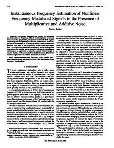
(a).MODIS 185
(b).MODIS265
(c).ETM+192
(d).ETM+272
(e).pETM+192
(f).pETM+272
(g).MPD_pETM+192
(h).MPD_pETM+272
Figure 1. Surface classification map based on ETM+192. In this study the albedo of each land cover type is computed through the decomposition method of linear mixed model, and its implementation process including: first, conduct land cover classification with ETM+ reflectance image on the 192nd day of 2001, classification result is shown in Figure 1; second, carry out mixed pixel decomposition with all MODIS albedo images using the land cover classification map, and then replace MODIS albedo images with the decomposition results as the coarse resolution albedo images to be blended with ETM+ albedo images. The renewed MODIS albedo data is used for high temporal and spatial albedo estimation. 3. RESULTS MODIS albedo on the 144th (224th) day and ETM+ albedo on the 137th (217th) day were considered to be the two pairs of the STARFM’s base images, albedo of 30m resolution on the 192nd day and the 272nd day were estimated when concurrent MODIS albedo introduced. Albedo derived directly from ETM+192 and ETM+272 with NTB model were used for validation. As shown in Figure 2, both albedo estimated using original STARFM and improved STARFM model depict the spatial detail well, and the spatial distribution patterns are consistent with those of MODIS and ETM+. Figure 3 shows the scatter plots of the estimated albedo and ETM+ albedo by NTB model. Results showed that both shortwave albedos estimated by original and improved STARFM model achieve a reasonable accuracy, with a root mean square error less than 0.03, which has been considered to meet the requirements of driving global and regional climate models [2]. By introducing mixed pixel decomposition method and replacing MODIS albedo with the decomposed albedo, the improved model can get a higher accuracy. When the RMSE of pETM+192 and pETM+272 estimated with the original model are 0.0176 and 0.0195, the RMSE of MPD_pETM+192 and MPD_pETM+272 estimated with the improved model decreased to 0.0154 and 0.0185 respectively.
Figure 2. Shortwave albedo images of MODIS, Landsat ETM+ and estimated albedo by STARFM on the 192nd and 272nd day. “pETM+” refers to shortwave albedos estimated by original STARFM, and “MPD_pETM+” refers to shortwave albedos estimated by the improved STARFM. 4. CONCLUSION AND DISCUSSION This study proposed a method to estimate land surface shortwave albedo with high temporal and spatial resolution. Compared with ETM+ albedo, the results showed that the estimated albedo maintained a high level of spatial detail, both the results of the original and improved STARFM model are of high accuracy, when the result of improved model has an even higher accuracy, which indicate that the
2890
proposed method is an available way for high temporal and spatial resolution albedo estimation and could be used to predict time series shortwave albedo with 30-meter spatial resolution.
(a). pETM+192
[1] R. E. Dickinson, "Land surface processes and climate—Surface albedos and energy balance," Advances in Geophysics, vol. 25, pp. 305-353, 1983. [2] Y. Shuai, J. G. Masek, F. Gao, and C. B. Schaaf, "An algorithm for the retrieval of 30-m snow-free albedo from Landsat surface reflectance and MODIS BRDF," Remote Sensing of Environment, vol. 115, pp. 2204-2216, Sep 15 2011. [3] S. Liang, "Narrowband to broadband conversions of land surface albedo I: Algorithms," Remote Sensing of Environment, vol. 76, pp. 213-238, 2001. [4] J. Ju and D. P. Roy, "The availability of cloud-free Landsat ETM+ data over the conterminous United States and globally," Remote Sensing of Environment, vol. 112, pp. 1196-1211, 2008. [5] F. Gao, J. Masek, M. Schwaller, and F. Hall, "On the blending of the Landsat and MODIS surface reflectance: Predicting daily Landsat surface reflectance," Geoscience and Remote Sensing, IEEE Transactions on, vol. 44, pp. 2207-2218, 2006. [6] T. Hilker, M. A. Wulder, N. C. Coops, N. Seitz, J. C. White, F. Gao, J. G. Masek, and G. Stenhouse, "Generation of dense time series synthetic Landsat data through data blending with MODIS using a spatial and temporal adaptive reflectance fusion model," Remote Sensing of Environment, vol. 113, pp. 1988-1999, 2009. [7] T. Kalvelage and J. Willems, "Supporting users through integrated retrieval, processing, and distribution systems at the Land Processes Distributed Active Archive Center," Acta astronautica, vol. 56, pp. 681-687, 2005. [8] L. A. Remer, Y. Kaufman, D. Tanré, S. Mattoo, D. Chu, J. V. Martins, R. R. Li, C. Ichoku, R. Levy, and R. Kleidman, "The MODIS aerosol algorithm, products, and validation," Journal of the Atmospheric Sciences, vol. 62, pp. 947-973, 2005. [9] L. A. Remer, D. Tanré, Y. J. Kaufman, R. Levy, and S. Mattoo, "Algorithm for remote sensing of tropospheric aerosol from MODIS: Collection 005," National Aeronautics and Space Administration, 2006.
(b). MPD_pETM+192
(c). pETM+272 (d). MPD_pETM+272 Figure 3. Scatter plots of ETM+ shortwave albedo derived from Landsat data and predicted by STARFM. There are still some shortcomings of this method. ETM+ surface reflectance is regarded as instantaneous, so does the ETM+ albedo with NTB model; yet MODIS albedo product is 16 days-composed; the incomplete consistence of acquisition time could be a possible reason of estimation error. Furthermore, the results are only compared with limited validation data, more ground validation works are still needed. ACKNOWLEGEMENT This research was supported by the National Basic Research Program of China under grant 2013CB733403, and the National Natural Science Foundation of China under grant 41171263. REFERENCES
2891