5.4 SMALL POLYGON COMPRESSION FOR INTEGER COORDINATES Abhinav Jauhri, Martin Griss & Hakan Erdogmus∗ Carnegie Mellon University, Moffett Field, California
arXiv:1509.05505v1 [cs.IT] 18 Sep 2015
ABSTRACT
gon, though currently many operators use rather coarsegrained targeting (such as to a whole county). Our research group has developed and evaluated improved geo-targeting technology. For testing purposes, we ran trials of the new system, called by us WEA+. We are using SMS (and WiFi) to simulate cell broadcast, and also have on campus an experimental cell system, CROSSMobile [10], that supports true cell broadcast on an unused GSM frequency to cell phones with a special SIM card. In order to do this, we included some compressed polygon representation as part of the short message text, expected to be feasible in both current 90 WEA character messages and even more effective in future implementations of WEA that allow longer messages, or use multiple messages. We have available to us a corpus of 11,370 WEA messages sent out by the National Weather Service (NWS) [13]2 . The polygons in the NWS corpus range from 4-24 points, with a size ranging from 43-331 characters. Since WEA messages are broadcast to thousands of people, and it is believed that adding a polygon to more precisely define the target area is critical, it is essential to be able to compress typical WEA polygons to fit within the current or anticipated future WEA message length, leaving room for meaning text as well. In this paper, we explore several ways of substantially compressing such polygons using heuristics and standard algorithms. Our techniques provide better compression for almost all polygons in the corpus than standard algorithms.
We describe several polygon compression techniques to enable efficient transmission of polygons representing geographical targets. The main application is to embed compressed polygons to emergency alert messages that have strict length restrictions, as in the case of Wireless Emergency Alert messages. We are able to compress polygons to between 9.7% and 23.6% of original length, depending on characteristics of the specific polygons, reducing original polygon lengths from 43-331 characters to 8-55 characters. The best techniques apply several heuristics to perform initial compression, and then other algorithmic techniques, including higher base encoding. Further, these methods are respectful of computation and storage constraints typical of cell phones. Two of the best techniques include a “bignum” quadratic combination of integer coordinates and a variable length encoding, which takes advantage of a strongly skewed polygon coordinate distribution. Both techniques applied to one of two “delta” representations of polygons are on average able to reduce the size of polygons by some 80%. A repeated substring dictionary can provide further compression, and a merger of these techniques into a “polyalgorithm” can also provide additional improvements.
1.
INTRODUCTION
Geo-targeting is widely used on the Internet to better target users with advertisements, multimedia content, and essentially to improve the user experience. Such information helps in marketing brands and increasing user engagement. Scenarios also exist where geo-targeting at a given time becomes imperative for specific sets of people for information exchange, thereby contributing to problems of network congestion and effectiveness. Emergency scenarios are a quintessential example where people in the affected area need to be informed and guided throughout the duration of an emergency. To address this, Wireless Emergency Alerts (WEA) is a nation-wide system for broadcasting short messages1 (currently 90 characters, similar to SMS messages) to all phones in a designated geographic area via activation of appropriate cell towers. The area is typically identified by a poly-
The compression problem we are tackling here is quite different from that described in most other published research on polygon compression [1, 6]. They typically are dealing with a large number of inter-connected polygons in a 2D or 3D representation of a surface or solid, and thus are compressing a large number of polygons at the same time. Many of these polygons share common points and edges, which can be exploited in the compression; in our case, we have a single, relatively small polygon to compress, and so can not amortize items such as a dictionary of common points. In designing our techniques, we have looked at the typical distribution of coordinate values, polygon sizes and character string length of original uncompressed polygons, shown in Figures 2a and 2b. Many of these charac-
∗ Corresponding author address: Abhinav Jauhri, Carnegie Mellon University, ECE Department, Moffett Field, CA 94035; email:
[email protected] 1 https://www.fema.gov/wireless-emergency-alerts
2 These messages were sent out by the NWS in 2012, 2013, and through December, 2014
1
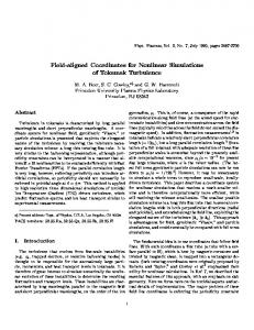
Figure 1: A map showing 3 polygons (yellow border). The NWS dataset has both convex and non-convex polygons
teristics have motivated our transformations of the original polygon. In the NWS corpus the observed range of GPS coordinates, covering a significant portion of the USA, is:
A key constraint is to compress the polygon into a string of characters that are acceptable via SMS or cell broadcast and specifically to the gateways we use to send an SMS via email for our pilot trials. To compress the set of decimals (or bits) representing GPS coordinates, we use a base B representation, avoiding characters that are questionable. This is discussed further in the practical considerations section. Base B = 62 is a convenient choice since it uses only alphanumeric characters [0-9azA-Z]. Using a higher base such as B = 70 or B = 90 uses more characters and will improve the overall compression, and changes the trade-off between techniques. Briefly, our paper explores numerous techniques of compression on different transformations, or manipulations to the original polygon.
(X, Y ) = (17.67, −159.32) to (48.84, −64.56) We use three types of transformations on the numeric strings representing a polygon. The first group exploits heuristics, redundancies and patterns in the GPS coordinates, substantially simplifying and reducing the number of numeric characters in most polygon coordinates. The next set of transformations encodes the now simplified coordinates in a higher base, B, such as all alpha-numeric characters, and then applies arithmetic and character string operations to further compress each polygon. The final set of transformations uses the statistical nature of the entire set of polygons to further compress some polygons. We evaluated our corpus of polygons with combinations of the following compression techniques:
2.
HEURISTIC APPROACHES
We have combined several heuristics, motivated by analysis and discovered experimentally to work well. The following describes our current techniques. We start with an original N point polygon, given as an ordered finite sequence in R2 :
1. Purely heuristic, using deltas and fixed or variable length fields 2. Encoding in a higher base
O = [X1 , Y1 , . . . , XN , YN ]
3. Using a repeated substring dictionary to replace most frequent occurring substrings
where Xi , Yi are GPS coordinates in decimal degrees. In the NWS corpus, N ∈ [4, 24], even though the NWS standard allows polygons of up to 100 points. The original uncompressed polygon length of 43 to 331 characters includes 2N − 1 separating commas, 2N periods and N minus signs. Since Xi is typically dd.dd and Yi is typically −dd.dd or −ddd.dd, the total length of the original polygon string O is:
4. Arithmetic operations to combine values 5. Arithmetic encoding, an entropy based compression technique 6. Other standard algorithms - LZW [12], 7zip, gzip, Huffman [9] and Golomb [8] 2
(a) Distribution of polygon vertices
(b) Distribution of original polygon lengths
Figure 2: Distribution of NWS data
len(O) = 62) characters. A higher base, such as base 70, can represent even larger integers in fewer characters: a single base-70 “bigit” b can represent an integer up to 69, two base-70 bigits bb can represent an integer up to 4899, and three base-70 bigits bbb can represent integers up to 342999. Likewise, dXmin can be encoded in two base 70 bigits and dYmin can be encoded in two or three base 70 bigits. Because of the choice of values for X0 and Y0 , the restricted ranges and skew of dXmin and dYmin allow most to pack within two base-70 characters. For our analysis and experiments of compression techniques, we will use B = 70 with all alphanumeric characters and some allowable special characters used in SMS. String H70 (Tc∆min ) is the transformation of the commadelimited values in base-70. For example, if Tc∆min = [9, 60, 70], then H70 (Tc∆min ) =“9,y,10”. The upper bound on the length is then:
(2)
Tc∆ = δX1 •, •δY1 •, •∆X2 •, • ∆Y2 •, • . . . • ∆XN −2 •, •∆YN −2
(3)
Symbol • is used to denote string concatenation. Figure 5 shows the distribution of lengths using this transformation. Since all deltas, dXi , dYi are less than 350, (and ∆Xi , ∆Yi are less than 550) each of these deltas can be encoded in at most three decimal digits, ddd, while dXmin or δX1 will take at most four digits, dddd, and dYmin or δY1 at most five digits, ddddd. The lower bound on the length of Tc∆min is thus: len(Tc∆min ) >= |{z} 1 + |{z} 1 + (N − 1) + (N − 1) + 2N − 1 | {z } | {z } | {z } dXmin
dYmin
dXi
commas
dYi
>= 4N − 1
len(H70 (Tc∆min )) = |{z} 1 + |{z} 1 + (N − 1) | {z } dXmin
(5)
= 4N − 1
and 8N − 6 for Tc∆ . We can eliminate all commas by using fixed three digit fields for each delta, padded with zero, four digits for dXmin and δX1 and five digits for dYmin and δY1 to get a significant improvement (Figure 5b) over len(Tc∆min ) or len(Tc∆ ), called Tf∆min or Tf∆ : dXmin
dYmin
+ (N − 1) + 2N − 1 | {z } | {z }
commas
len(Tf∆min )
(7)
commas
dYi
dYi
+ 2N − 1 | {z }
dXi
= 2N + 2
0 00 dYmin = B ∗ dYmin + dYmin or δY1 = B ∗ δY10 + δY100 (11)
2 |{z}
+
+ (N − 1) + (N − 1) | {z } | {z }
0 00 dXmin = B ∗ dXmin + dXmin or δX1 = B ∗ δX10 + δX100 (10)
∆min len(V AR64 )