8. Figure S1B. Observed vs. metamodel-predicted NO3. - at water table in 1980, mg/L (NO3_WT_mgL_1980) (training R2 = 0.60; hold-out R2 = 0.52) ...
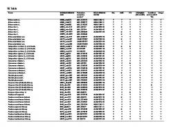
Table S1. Predictor variables in the boosted regression tree metamodels. Variable
Point or Buffer
Description
Source
Location Dec_Lat
Point
Decimal latitude
Dec_Long
Point
Decimal longitude
Alt_ft
Buffer
Land surface elevation, ft
A_As
Buffer
Arsenic concentration in A soil horizon, mg/kg
A_C_Inorg
Buffer
Inorganic carbon concentration in A soil horizon, weight %
A_C_Org
Buffer
Organic carbon concentration in A soil horizon, weight %
USGS Groundwater Data for the Nation: National Water Information System. Available at https://waterdata.usgs.gov/nwis/gw USGS 30 m National Elevation Dataset. Available at https://gdg.sc.egov.usda.gov/Catalog/ProductD escription/NED.html
Soils
A_Fe
Buffer
Iron concentration in A soil horizon, weight %
A_Mn
Buffer
Manganese concentration in C soil horizon, mg/kg
A_P
Buffer
Phosphorus concentration in the A soil horizon, mg/kg
A_S
Buffer
Sulfur concentration in the A soil horizon, weight %
C_As
Buffer
Arsenic concentration in C soil horizon, mg/kg
C_C_Inorg
Buffer
Inorganic carbon concentration in C soil horizon, weight %
1
Smith, D.B., Cannon, W.F., Woodruff, L.G., Solano, Federico, Kilburn, J.E., and Fey, D.L., 2013, Geochemical and mineralogical data for soils of the conterminous United States: U.S. Geological Survey Data Series 801, 19 p. Available at http://pubs.usgs.gov/ds/801/. Data were gridded and resampled at 10 m by 10 m resolution.
Variable
Point or Buffer
Description
Source
C_C_Org
Buffer
Organic carbon concentration in C soil horizon, weight %
C_Fe
Buffer
Iron concentration in C soil horizon, weight %
C_Mn
Buffer
Manganese concentration in C soil horizon, mg/kg
C_P
Buffer
Phosphorus concentration in the A soil horizon, mg/kg
C_S
Buffer
Sulfur concentration in the C soil horizon, weight %
AVG_CLAY
Buffer
Area- and depth-weighted average percent clay
AVG_POR
Buffer
Porosity = 100(1 - (moist bulk density/particle density))
AVG_SILT
Buffer
Area- and depth-weighted average percent silt
AVG_OM
Buffer
Area- and depth-weighted value of organic matter content (percent by weight).
DrnClass_2
Buffer
Percent soil drainage class identifying the natural drainage condition of the soil as moderately well drained
DrnClass_3
Buffer
Percent soil drainage class identifying the natural drainage condition of the soil as not applicable
DrnClass_4
Buffer
Percent soil drainage class identifying the natural drainage condition of the soil as poorly drained
DrnClass_5
Buffer
Percent soil drainage class identifying the natural drainage condition of the soil as somewhat excessively drained
2
U.S. Department of Agriculture. (2014). Soil Survey Geographic (SSURGO) Database. Natural Resources Conservation Service. Available at https://datagateway.nrcs.usda.gov/ Wieczorek, M. (2014). Area-weighted and depthweighted averages of selected SSURGO variables for the conterminous United States and District of Columbia. Data Series 866. Available at https://pubs.er.usgs.gov/publication/ds866
Variable
Point or Buffer
Description
Source
DrnClass_6
Buffer
Percent soil drainage class identifying the natural drainage condition of the soil as somewhat poorly drained
Drainage
Buffer
Calculated as weighted average of drainage classes ranked from low to high (1-7), where 1=very poorly drained (class 8); 2=poorly drained (class 4); 3=somewhat poorly drained (class 6); 4=moderately well drained (class 2); 5=well drained (class 9); 6=somewhat excessively drained (class 5); 7=excessively well drained (class 1)
HydGrp_B
Buffer
Soil hydrologic group B; soils with a moderate rate of infiltration rate when wet, and with moderately fine to moderately coarse texture.
HydGrp_BD
Buffer
Soil hydrologic group BD; the first letter is for drained areas and the second is for undrained areas, where D soils having a very slow rate of infiltration rate when wet, indicative of a high water table, a clay layer, or shallow soils over lowpermeability material.
KFACT
Buffer
Soil erodibility factor
AWS025WTA
Buffer
Available water storage, weighted average, centimeters of water. The volume of water that the soil, to a depth of 25 centimeters, can store that is available to plants.
WTDEPANNMIN
Buffer
The shallowest depth to a wet soil layer (water table) at any time during the year expressed as centimeters from the soil surface, for components whose composition in the map unit is equal to or exceeds 15%.
Aquifer texture
3
Variable
Point or Buffer
Description
Source
CAT1_ds656
Buffer
Coarse-grained stratified sediment
CF_Lay1
Buffer
Percent coarse fraction from well log data for MODFLOW model layer 1
CF_Lay2
Buffer
Percent coarse fraction from well log data for MODFLOW model layer 2
CF_Lay3
Buffer
Percent coarse fraction from well log data for MODFLOW model layer 3
BV_Cambrian
Buffer
Binary variable indicating presence or absence of Cambrian age bedrock underlying sampled wells
BV_Ordovician
Buffer
Binary variable indicating presence or absence of Ordivician age bedrock underlying sampled wells
BV_Silurian
Buffer
Binary variable indicating presence or absence of Silurian age bedrock underlying sampled wells
Buffer
Fraction of 1974 Residential, low-medium density land in well buffer
Soller, D.R., Packard, P.H., and Garrity, C.P., 2012, Database for USGS Map I-1970 — Map showing the thickness and character of Quaternary sediments in the glaciated United States east of the Rocky Mountains: U.S. Geological Survey Data Series 656. Available at http://pubs.usgs.gov/ds/656/.
Juckem, P.J., B.R. Clark, and D. T. Feinstein, 2017, Simulation of groundwater flow in the glacial aquifer system of northeastern Wisconsin with variable model complexity: U.S. Geological Survey Scientific Investigations Report 2017–5010, 52 p. Available at https://doi.org/10.3133/sir20175010.
Bedrock age Nicholson, S. W., C. L. Dicken, M. P. Foose, and J. A. L. Mueller (2004), Preliminary integrated geologic map databases for the United States: The Upper Midwest States: Minnesota, Wisconsin, Michigan, Illinois and Indiana, U.S. Geological Survey Open-File Report 2004-1355. Available at https://pubs.usgs.gov/of/2004/1355/.
Land use CAT26_lu74
CAT26_lu92
Buffer
Fraction of 1992 Residential, low-medium density land in well buffer
CAT27_lu74
Buffer
Fraction of 1974 Developed, other land in well buffer
4
Falcone, J.A., 2015, U.S. conterminous wall-to-wall anthropogenic land use trends (NWALT), 1974– 2012: U.S. Geological Survey Data Series 948, 33 p. plus appendixes 3–6 as separate files, http://dx.doi.org/10.3133/ds948. Available at http://dx.doi.org/10.3133/ds948.
Variable
Point or Buffer
Description
Source
CAT27_lu92
Buffer
Fraction of 1992 Developed, other land in well buffer
CAT43_lu74
Buffer
Fraction of 1974 Crops in well buffer
CAT43_lu92
Buffer
Fraction of 1992 Crops in well buffer
CAT44_lu74
Buffer
Fraction of 1974 Pasture/Hay in well buffer
CAT44_lu92
Buffer
Fraction of 1992 Pasture/Hay in well buffer
CAT50_lu74
Buffer
Fraction of 1974 Low use land in well buffer
CAT50_lu92
Buffer
Fraction of 1992 Low use land in well buffer
Sum_forest
Buffer
Sum of fractions of NLCD categories 41, 42, and 43
Sum_wetl
Buffer
Sum of fractions of NLCD categories 90 and 95
Homer, C., C. Huang, L. Yang, B. Wylie and M. Coan, 2004. Development of a 2001 national land cover database for the United States. Photogrammetric Engineering and Remote Sensing Vol.70, No.7, pp 829-840. Available at https://www.mrlc.gov/nlcd2001.php.
Dist_str
Point
Computed as distance between sampled well and the nearest stream, ln(feet), based on WDNR 24K hydrography data.
Wisconsin Department of Natural Resources surface water (hydrography) data. Available at http://dnr.wi.gov/maps/gis/datahydro.html
DTWJuckem
Point
Depth to water, feet, calculated as land surface elevation minus MODFLOW simulated water table elevation.
Recharge1Juckem
Point
MODFLOW estimates of recharge, in/yr
Juckem, P.J., B.R. Clark, and D. T. Feinstein, 2017, Simulation of groundwater flow in the glacial aquifer system of northeastern Wisconsin with variable model complexity: U.S. Geological Survey Scientific Investigations Report 2017–5010, 52 p. Available at https://doi.org/10.3133/sir20175010.
Recharge2Sanford
Point
Regression estimates of effective recharge, m/yr, 2000-2013
Landscape/hydrology
5
Reitz, Meredith, Sanford, Ward E., Senay, Gabriel B., and Cazenas, Jeffrey, 2017, Annual estimates of recharge, quick-flow runoff, and ET for the contiguous US using empirical regression
Variable
Point or Buffer
Description
Source equations, 2000-2013: U.S. Geological Survey data release, https://doi.org/10.5066/F7PN93P0.
Recharge
Buffer
Mean annual groundwater recharge, mm/yr
Wolock, D.M., 2003, Estimated mean annual natural ground-water recharge in the conterminous United States. Available at http://water.usgs.gov/lookup/getspatial?rech48grd
Precip
Point
Long-term average precipitation (1981–2010), mm
PRISM Climate Group, Oregon State University. Available at http://www.prism.oregonstate.edu/mtd/
Point
Model predicted probability that groundwater iron concentration exceeds 0.1 mg/L
Tesoriero et al., Predicting redox-sensitive contaminant concentrations in groundwater using random forest classification. In review at Water Resour. Res.
Redox conditions Pred_Iron
6
Figure S1A. Observed vs. metamodel-predicted N source concentration factor (VFM_fcN) (training R2 = 0.52; hold-out R2 = 0.45).
7
Figure S1B. Observed vs. metamodel-predicted NO3- at water table in 1980, mg/L (NO3_WT_mgL_1980) (training R2 = 0.60; hold-out R2 = 0.52)
8
Figure S1C. Observed vs. metamodel-predicted NO3- at water table in 2000, mg/L (NO3_WT_mgL_2000) (training R2 =
0.54; hold-out R2 = 0.49)
9
Figure S1D. Observed vs. metamodel-predicted NO3- at water table in 2020, mg/L (NO3_WT_mgL_2020) (training R2 =
0.68; hold-out R2 = 0.54)
10
Figure S1E. Observed vs. metamodel-predicted log-transformed nitrate extinction depth, m (Zss_N_ext_depth) (training R2 = 0.86; hold-out R2 = 0.78)
11
Figure S1F. Observed vs. metamodel-predicted log-transformed unsaturated zone travel time, yrs (VFM_travel_time_yrs) (training R2 = 0.76; hold-out R2 = 0.69)
12
Figure S2. Relative influence of predictor variables in final metamodels. N source concentration factor (VFM_fcN)
NO3- at water table in 1980, mg/L (NO3_WT_mgL_1980)
NO3- at water table in 2000, mg/L (NO3_WT_mgL_2000)
NO3- at water table in 2020, mg/L (NO3_WT_mgL_2020)
Nitrate extinction depth, m (Zss_N_ext_depth)
Unsaturated zone travel time, yrs (VFM_travel_time_yrs)
13
Figure S3. Partial dependence plots for N source concentration factor (VFM_fcN)
14
Figure S4. Partial dependence plots for NO3- at water table in 1980, mg/L (NO3_WT_mgL_1980)
15
Figure S5. Partial dependence plots for NO3- at water table in 2000, mg/L (NO3_WT_mgL_2000)
16
Figure S6. Partial dependence plots for NO3- at water table in 2020, mg/L (NO3_WT_mgL_2020)
17
Figure S7. Partial dependence plots for NO3- extinction depth, m (Zss_N_ext_depth)
18
Figure S8. Partial dependence plots for unsaturated zone travel time, yrs (VFM_travel_time_yrs)
19
Figure S9. 1974 cropland (cat43_lu74) in the Fox-Wolf-Peshtigo study area (proportion in pixel).
20
Figure S10. Drainage characteristic (Drainage) in the Fox-Wolf-Peshtigo study area, where 1=very poorly drained and 7 =excessively well drained.
21
Figure S11. MODFLOW-estimated recharge (in/yr) (Recharge1Juckem) in the Fox-Wolf-Peshtigo study area (Juckem et al., 2017).
22
Figure S12. Average percent clay in the Fox-Wolf-Peshtigo study area.
23
Figure S13. Percent somewhat poorly drained soils (DrnClass_6) in the Fox-Wolf-Peshtigo study area.
24
Figure S14. Land surface elevation (ft) (Alt_ft) in the Fox-Wolf-Peshtigo study area.
25
Figure S15. Depth to water (ft) (DTWJuckem) in the active MODFLOW model area of the Fox-Wolf-Peshtigo study area (Juckem et al., 2017).
26
References Juckem, P.F., Clark, B.R., Feinstein, D.T., 2017. Simulation of groundwater flow in the glacial aquifer system of northeastern Wisconsin with variable model complexity. U.S. Geological Survey Scientific Investigations Report 2017-5010, Reston, VA. DOI:10.3133/sir20175010.
27