Visualization of Off-Screen Objects in Mobile Augmented Reality Torben Schinke
Niels Henze
Susanne Boll
University of Oldenburg Oldenburg, Germany
University of Oldenburg Oldenburg, Germany
University of Oldenburg Oldenburg, Germany
[email protected]
[email protected]
[email protected]
ABSTRACT An emerging technology for tourism information systems is mobile Augmented Reality using the position and orientation sensors of recent smartphones. State-of-the-art mobile Augmented Reality application accompanies the Augmented Reality visualization with a small mini-map to provide an overview of nearby points of interest (POIs). In this paper we develop an alternative visualization for nearby POIs based on off-screen visualization techniques for digital maps. The off-screen visualization uses arrows directly embedded into the Augmented Reality scene which point at the POIs. In the conducted study 26 participants explored nearby POIs and had to interpret their position. We show that participants are faster and can interpret the position of POIs more precisely with the developed visualization technique.
Categories and Subject Descriptors H.5.1 [Multimedia Information Systems]: Artificial, augmented, and virtual realities
General Terms Design, Human Factors, Experimentation
Keywords Augmented Reality, Mobile Phone, Orientation
1.
INTRODUCTION
Despite the worldwide financial crisis tourism remains one of the largest economic sectors with about 30% of the worldwide export business [1]. The results of Morrison et al. [8] suggests that digital maps or digital extensions for paper maps are not the perfect companion for tourists and even today the two most important tools for tourists are paper maps and printed tourist guides. Davies et al. [5] show that a system’s technical maturity and perfectness is not the most important aspect. In fact, it’s the interaction a system provides. Davies’ results suggest that tourists either want a list of all sights in their environment (”What’s near?”) or detailed information about a specific object (”What’s that?”). A promising presentation technique to answer these questions is mobile Augmented Reality to display information Copyright is held by the author/owner(s). MobileHCI’10, September 7–10, 2010, Lisbon, Portugal. ACM 978-1-60558-835-3/10/09.
about points of interests (POIs). Due to recent technical advances mobile Augmented Reality applications for Smartphones using a digital compass and GPS became available to end-users. While the phone’s display shows the camera’s video a 3D overlay highlights sights in the physical scene. Applications, such as Wikitude, Layar, or Google’s Goggles available for the Android platform have each been installed some hundred thousand times - in a few months. The augmented scene only provides information about POIs inside the viewport of the camera. It does not provide an overview about so-called off-screen objects - objects that are outside the viewport because they are besides or behind the user. Current mobile Augmented Reality applications (e.g. Wikitude or Layar) for tourists provide the user with an overview about nearby sights using an additional minimap, usually centered in the lower half of the display. The augmented environment and the mini-map, however, have different reference systems. Therefore, interpreting the 2D mini-map and align it with the augmented environment demands mental effort. We assume that an off-screen visualization directly embedded into the augmentation reduces this mental effort. In this paper we design a 3D visualization of off-screen objects for mobile augmented reality applications. Our aim is to determine if mobile augmented reality applications for tourists can be improved by replacing the small mini-map with the developed visualization of nearby objects. In the remainder of this paper, we present the related work in Section 2. The used visualization techniques are described in Section 3. We present the design of the conducted user study in Section 4. The results are outlined in Section 5 followed by a discussion in Section 6. We close the paper with a conclusion and outlook to future work in Section 7.
2.
RELATED WORK
Providing information about physical objects using mobile devices has received a great share of attention in recent years. Davies et al. [5], for example, studied the difference between two interaction techniques to acquire information about nearby POIs. They compared an interaction that enables users to take a photo of a sight and receive according information (the so-called point-and-shoot interaction) with an interactive list of POIs in the surrounding. Davies et al. found that users are happy to use image recognition even when this is a more complex, lengthy and error-prone process than traditional solutions. Augmented reality for handheld devices is a similar interaction technique that enables users to aim at a physical
object to acquire information about it. Contrary to pointand-shoot, augmented reality provides instant and continuous feedback to the user. Most research for handheld augmented reality focused on adapting algorithms for mobile devices which is still an open field (see e.g. [10]). However, recently Smartphone manufacturers began to include a compass into their phones. Accompanied by a GPS receiver augmented reality based on pure sensor data became possible [7]. Besides providing information by augmenting sights applications for tourists must also provide an overview about the environment. Existing mobile augmented reality applications that are based on GPS and compass data present a small mini-map side-by-side with the augmentation. The mini-map is used to present so-called off-screen objects (i.e. objects that are not visible in the current camera image presented on the screen). Visualizing off-screen objects has received some attention for other use-cases. Zellweger et al. [11] introduced City Lights, a principle for visualizing off-screen objects for hypertext. An extension of the City Lights concept for digital maps is Halo [2]. For Halo circles are drawn around the object in the virtual off-screen. Users can interpret the position of the POI by extrapolating the circular arc. Baudisch et al. showed that users achieve better results when using Halo instead of arrows with a labeled distance [2]. Burigat et al. [4] reviewed these results by comparing Halo with different arrow types e.g. by visualizing distance through scaling the arrows. They found that arrow-based visualizations outperform Halo, in particular, for complex tasks. Other off-screen visualization have been developed (e.g. Wedge [6]) but it has not been shown that these outperform existing approaches. Off-screen visualization techniques have also been applied to virtual environments and augmented reality. Chittaro and Burigat [3] compared 2D and 3D arrows as well as map like techniques to present a single destination in virtual environments. They showed that inexperienced users were better when using 3D arrows. Tonnis et al. [9] developed and evaluated 3D arrows and a map like visualization technique in an augmented reality application for cars that presents a source of danger. They conclude from their study that there is a significant advantage for 3D arrows in case of reaction times over the map like method.
3.
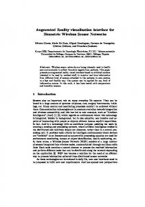
Figure 1: Conception of the visualizations: a) Scene from top b) mini-map and c) 3D arrows
To compare the arrow based visualization with the stateof-the-art we implemented a mini-map that also rotates with the orientation of the phone. A highlighted cone shows the area of the real world that is visible on the phone’s display. To obtain comparable results the mini-map is centered at the same location with the same size as the arrows. To highlight POIs inside the camera’s video we use circles that overlay the objects inside the physical scene. If a POI is near the centre of the display a short description is painted on top of a semiellipse connected to the circle by a thin line. The system was implemented for Android Smartphones. A screenshot containing a side-by-side comparison of the application’s two presentation techniques is shown in Figure 2.
4.
USER STUDY
To compare the arrow based visualization of nearby POIs with mini-maps we conducted a user study with the system described above. In the experiment participants performed two tasks using the system. Our assumption was that participants are faster with the arrow based technique because they do not have to mentally align two different reference systems. Thus, we also expected that participants perceive it as more intuitive. However, we assumed that participants can localize POIs more precisely with the mini-map because
VISUALIZATION DESIGN
We assume that a 2D map presented besides the augmented scene, as in Figure 1.b, demands effort to be interpreted. We started with the concept of off-screen objects and transferred it in 3D to embed the visualization into the scene. Arrows that directly point at nearby POIs are arranged around a circle. The centroid of each arrow is located on this circle and thus, all arrows are on the same plane. The center of the circle is moved in front of the user’s position to be inside the viewport. To reduce occlusion among the arrows the plane is slightly tilted towards the user. The arrows rotate according to the orientation of the phone, just like a compass with multiple needles. To present the distance between the viewer and the object the arrows are scaled in length according to this distance. The scale factor can be adjusted just like the zoom level in digital maps. As shown in Figure 1.c, arrows are not hidden if an off-screen object becomes an on-screen object (i.e. the object is visible inside the camera’s video) to avoid confusing the user.
Figure 2: Screenshot with both visualizations for illustration purpose. Only one was used at a time for the evaluation.
of their experience with map usage and because of the more abstract 2D visualization.
4.1
Design
The experiment’s independent variable was the visualization technique used to present POIs. In the control condition, participants used a mini-map and in the experimental condition they used the arrow based visualization instead. The study consisted of two tasks. We used a repeatedmeasures design for both tasks. The tasked are always performed in the same order but the order of the conditions have been counterbalanced to reduce sequence effects.
4.2
Tasks
For the first task the device displayed four virtual POIs randomly distributed around the user. Participants’ task was to read the names of the POIs. In order to do that, they had to search for the POIs by turning around on the spot. A POI’s name was written on the top of the screen if the POI was located at the centre of the display. The dependent variables were the time needed to read the names of all POIs and a rating of the visualization technique on a six point scale. In the second task the device showed a set of four POIs all in sight and randomly selected from 12 nearby POIs (e.g. buildings, shops, and a bus station). Participants were asked to turn in a specific direction before starting the task and memorize the location of the POIs without turning around. After they finished memorizing, the device was removed, and participants had to tell which POIs were displayed. The dependent variables were the time needed to memorize the POIs and a rating of the visualization technique on a six point scale. In addition, the number of correctly estimated POIs and the difference between the named POIs and the displayed POIs in meters and angle were measured.
4.3
Procedure
We set up the evaluation booth on a public place in the city center of a medium size European city shown in Figure 3. The study was conducted on a Saturday from 11.00 to 16.00. Two teams of experimenters guided participants through the tasks simultaneously. Passersby were randomly asked to participate in the study. After a person had agreed to participate in the evaluation, the experimenter made the participants familiar with the concept of presenting POIs using Augmented Reality and the two visualization techniques. After conducting both tasks participants were interviewed to collect demographic information. In addition we asked participants to self-assess their experience with Smartphones, navigation skills, and experience with virtual reality (VE) on a six point scale.
4.4
Participants
We conducted the user study with 26 participants, 13 female and 13 male, aged 21-41 (M=22.4, SD=7.2). The subjects were passersby, so most of them were familiar with the local place. All subjects were volunteer, chosen without any selection by age, nationality or other criteria. None of them were familiar with the used application.
5.
RESULTS
After conducting the experiment we collected and analyzed the data. For the first task we could not identify sig-
Figure 3: Evaluation at a public place
nificant results. Therefore only the results of the second task will be discussed in the following. In addition to the differences between the visualization techniques, significant effects of gender and stated experience with virtual environments are also reported if applicable. Unless otherwise noted, a t-test is used to derive the p-values. Using the arrow visualization subjects correctly identified significantly (p=0.023) more POIs (M=2.2) than using the mini-map (M=1.6). In particular, males were significant better (p=0.045) when using the arrow based method (M=2.1) in contrast to the mini-map method (M=1.3). Furthermore participants who stated to be good in VE were also significant better (p=0,013) when using the arrow method (M=2.4 compared to M=1.3). To compare the positions of the displayed POIs with the positions stated by the participants the respective geocoordinates were used. Using these geo-coordinates the deviation in meters between these positions were calculated. Using arrows the distance between the POIs’ correct position and the guessed position was lower (M=18.0m) than using the mini-map (M=23.3m) but the difference is not significant. The difference of the distance from the user to the correct POI and the distance from the user to the guessed POI was smaller using arrows (M=29.9m) than using the mini-map (M=38.8m). However, the difference was also not significant. We calculated the angle between the displayed POIs and the guessed POI. The angular deviation was significantly smaller (p=0.027) using arrows (M=12.4◦ ) than using the mini-map (M=20.2◦ ) In particular, females profited from the arrows (M=9.7◦ ) and were significant better with arrows (p=0.030) than using the mini-map (M=18.2◦ ). Also subjects who stated to be good in VE were significant better (p