dynamic visualization of 3D spatial data such as buildings and other large objects ... 'information visualization' applications involve, for example, data mining.
WEB-BASED DYNAMIC VISUALIZATION OF 3D SPATIAL DATA Alias Abdul Rahman and Adnan Younas Institute of Geospatial Science and Technology, and Department of Geoinformatics, Faculty of Geoinformation Science and Engineering, Universiti Teknologi Malaysia 81310 UTM Skudai, Johor, Malaysia {alias,adnany}@fksg.utm.my
Abstract True 3D GIS requires lot of efforts from GIS research community both in academia as well as from software vendors. Visualizing 3D spatial data from DBMS for such 3D system is one of the issues and problems in 3D GIS domain. This paper discusses the dynamic visualization of 3D spatial data such as buildings and other large objects using geo-DBMS couples with Web that works with VRML and X3D modeling languages. The modeling of the 3D objects are based on the Simplified Data Model (SDM). The experiment will be presented by using digital 3D building datasets and the approach is applicable for tasks like 3D strata title and buildings management. Finally, it discusses the limitations and shortcomings of the current approach, and identifies future research and development tasks. Key words: 3D spatial data, VRML, X3D, visualization, and GeoDBMS.
1. Introduction Managing and manipulating 3D spatial data and eventually 3D spatial objects from database require specialized tools. One of the tools is visualization. Visualization via Web technology will be a plus point for data provider as well as for end users. Efficient and appealing presentation of 3D geospatial data on the Internet presents a challenging task for ongoing research on geo-visualization (Madden and Schiewe, 2003). The growing number of complexly structured data collections accessible over the global information network increasingly requires the support of appropriate visualization methods. Visualization is needed to support information retrieval by browsing and searching (Hemmje, Kunkel and Willett, 1994; Massari et. al., 1998), as well as data mining tasks for naive end users. Visualization of geographical information has been termed as ‘geo-visualization’. In comparison, ‘information visualization’ applications involve, for example, data mining applications, and whereas ‘scientific visualization’ involves the rendering of scientific results and research. Those involved with the perception of visualizations often speak
about ‘cognitive visualization’ where, those factors related to human perception and ability to identify objects visually - are studied and considered. Apart from the need for an integrated DBMS, there is also a trend of modeling the world in three dimensions. However, GIS applications, which use true 3D functionalities other than 3D visualizations are still rare. GIS and DBMS vendors seem to hesitate with full support for 3D. It seems that users are waiting for vendors to make the step to 3D, while vendors are waiting for an extensive request for 3D tools from their customers. In this respect, research into new 3D solutions can play a critical role (Stoter and Zlatanova 2003a). Three-dimensional visualization systems are applicable to various application domains. One example is the visualization of large data collections within information systems (Rorvig and Hemmje, 1998). Another important application area is electronic commerce. Three dimensional visualizations are a powerful means to increase the cognitive effectiveness of virtual shopping malls, virtual libraries, or virtual galleries for naive end users. Information systems to support large events, like trade fairs or congresses, can benefit from three-dimensional visualizations (Risse and Hemmje, 1997). A virtual reality overview of a building, e.g., display information about all apartments in a building also includes the detailed information about the apartments. Visitors can find the specific apartment with its ID and with the person name to which it belongs. To explore current possibilities, we built a prototype using Web technology. The used tools and techniques are from outside the GIS domain. In this research the potentials are studied of using these tools and techniques in GIS and geoinformation science. The prototype was built on a Oracle 10g, with PHP and VRML/X3D. It uses VRML for visualization. The aim of the prototypes is to show the possibilities and constraints of accessing 3D geo-information organized in a geo-DBMS, in order to contribute to 3D GIS developments. Related research can be found in (Nebiker, 2003; Belfore, 2002 and Luttermann and Grauer, 1999). This paper begins with a short description on how 3D geo-objects can be modeled in a DBMS. These data models (a topological model and a geometrical model) were used in our prototype. Section 3 contains a short description on VRML and X3D, the 3D formats used in the prototypes. In section 4 the prototypes are described, together with their functionalities. Finally, the paper provides some remarks on the findings and highlights the outlook of the prototype and some future works.
2. 3D Geo-Objects in DBMS GIS have evolved to spatial DBMS where spatial as well as non-spatial data are maintained in one integrated environment. To achieve this, mainstream DBMS like (Oracle, 2001; IBM, 2000; Informix ,2000; Ingress, 1994) have implemented spatial data types and spatial operators more or less similar to the OpenGIS Consortium Simple Features Specification for SQL (OGC,1999). The implementation consists of an SQL
extension that supports storage, retrieval, query and update of simple spatial features (points, lines and polygons). OGC specifications (OGC, 2003) are until now 2D, as are the implementations of spatial data types in the mainstream DBMS. The only 3D functionalities in 3D that are available in DBMS are length and perimeter in 3D (PostGIS, 2003; MapInfo, 2003) and spatial indexing in 3D, e.g. 3D R-tree in Oracle. Although current DBMS do not support 3D objects, however z-coordinates can be used to store 0D, 1D and 2D objects in 3D. Stoter and Zlatanova (2003b) describe how 3D geo-objects can geometrically be maintained in DBMS within current techniques. Arens et al (2003) have implemented support for a 3D primitive (polyhedron) in a DBMS. This implementation is based on the proposal of (Stoter and Oosterom, 2002). In (PostGIS, 2003) it is also described a topological implementation of 3D geo-objects in DBMS based on the Simplified Spatial Model (Zlatanova, 2000). The prototype presented in this paper is based on these DBMS model, which is implemented in Oracle Spatial 10g (Adnan et. al., 2005).
3D Objects Relationships
Figure 1: Complex 3D geo-object and its relationships
In Figure 1, a complex 3D object with different 3D sub-objects is shown. Also relationships among the different complex 3D sub-objects have been mentioned. When we need to store this 3D object into a spatial database management system there is a spatial object inside the database management system, we have to map its data with that. The detail of the Geometry object and the storage structure and information of a 3D object inside the database management is shown in the next section.
2.1
Schema of a spatial object
Conventional relational database systems do not provide the functionality to directly support VRML/X3D scene data. Object-relational and object-oriented database management systems have been developed to support the extension by new data types, as
they are required for new application domains, like multimedia or document handling. They provide the necessary mechanisms to support the modeling of VRML/X3D data types. Since most business data including GIS data are stored in relational DBMS we have chosen an object-relational DBMS as been widely acknowledged as the new generation relational DBMS (Stonebraker, 1996) for our development platform. In order to visualize geometrical objects, geometry column for each of the spatial primitives, i.e. node, line, face, and solid are created. The purpose of preparing these geometry columns is to integrate the spatial database into Map 3D for the purpose of displaying objects graphically. A geometry column consists of geometry object that represent a spatial feature, modeled as an ordered set of primitive elements, i.e. node, line, and polygon. In Oracle Spatial, the geometry column consists of a schema (MDSYS) that prescribes the storage, syntax, and semantics of supported geometric data types. The pre-defined object type SDO_GEOMETRY is: CREATE TYPE sdo_geometry AS OBJECT ( SDO_GTYPE NUMBER, SDO_SRID NUMBER, SDO_POINT SDO_POINT_TYPE, SDO_ELEM_INFO MDSYS.SDO_ELEM_INFO_ARRAY (SDO_STARTING_OFFSET, SDO_ETYPE, SDO_INTERPRETATION), SDO_ORDINATES MDSYS.SDO_ORDINATE_ARRAY) (list of ordinates); For example, see Figure 2:
Figure 2: Data set insertion into Polygon table
The core component to support VRML/X3D in this implementation of a VRML/X3D “Geometry” data type of Oracle spatial is used. A “Geometry” data type has been used to store VRML/X3D data as a complete and valid VRML/X3D scenes. Spatial “geometry” data type is also used for import and export of predefined scenes as well as transformations of the complete scene in to the database.
3.
VRML and X3D
In 1994 the Web3D Consortium launched VRML (Virtual Modeling Language), which became an international ISO standard in 1997. The basis for the development of VRML was to have a simple exchange format for 3D information. This format is based on the most used semantics of modern 3D applications - hierarchical transformations, illumination models, viewpoints, geometry, fog, animation, material characteristics and texture. The development of VRML has stopped since the Web3D Consortium started to work on a XML version of VRML, in order to integrate with other Web technologies and tools i.e., X3D (eXtensible 3D). The specifications of X3D have only recently become available on May, 2003. In our experiment we have used both X3D and VRML to visualize 3D geo-objects. The data structure of an X3D document is very much comparable to the data structure of a VRML file. So as far as the underlying data model is concerned, X3D must be seen as a subset of VRML (Web3D, 2003). The difference lies in the notation (the syntax) used. While VRML is text, with accolades for structuring, X3D is coded in XML, with 'tags' for structuring. This is a major advantage for on-the-fly retrieval, because of the ease of use of XML in Internet applications.
3.1
PHP and VRML/X3D Integration
PHP is becoming very popular language for creating dynamic websites, particularly for generating them from databases. However, 2D GIS are outdated. So what we want is a way to harness the power of PHP to create database-driven VRML worlds for new 3D GIS system. PHP can output any text information; the only thing that identifies the file type is the MIME type that gets sent by the web server before the file itself. Fortunately, in PHP, one has to take control of this very information. This requires sending the VRML MIME type (“model/vrml”), and then writing the appropriate VRML nodes. The server strips all PHP code when sending a response. So, on lines where only JSP code is present, the server simply sends blank lines back to the browser. It is necessary to include both PHP and VRML headers, and the content type must be changed before we set the VRML header, so the final result looks like this:
In this experiment, one of the objectives is to display a 3D building in VRML code using database. But in the start, it has been tested with the same type of data as used in Oracle Spatial to display a VRML file. Figure 3 shows the VRML file contains data in itself.
Figure 3: 3D Building’s VRML File
PHP scripting is added to this shape, which lets us use dynamic data to change the sphere’s position in space (translation X Y Z), its color (diffuseColor R G B), and its radius.
4. Prototype and Process Details The basic idea of the prototype is to organize 3D geo-objects in a DBMS and to query them via an Internet browser. Geo-objects contain both spatial and non-spatial (administrative) information. The spatial information can be visualized after conversion into VRML or X3D and the non-spatial attribute information can be presented in (dynamic) HTML pages. Figure 4 shows a standard request process—the page is requested via a browser. The request calls the designated PHP, which interacts with a database. The model given below explains the whole prototype process.
Request and Response Process Browser
PHP
SQL
Database
VRML / X3D
Figure 4: The Request and Response After receiving the response, the system follows the flow as shown in Figure 3. The database sends the requested data to the PHP, which formats the data and sends the response to the requesting browser. In our case study, the data is returned to the PHP, which then generates a VRML scene using the data from the database. On a client request a connection is made to the DBMS and the spatial information of interest is selected from the DBMS and converted into X3D/VRML. A browser plug-in at the client side makes it possible to view the VRML or X3D output. VRML and X3D provide the possibility to start a script when a user clicks on an object. This functionality is used to retrieve the non-spatial information that is linked to a 3D geo-object. Via the VRML/X3D plug-in a request is sent to a (application) server. The server receives and interprets the incoming information and sends a HTML with the required information back to the browser. For retrieving the spatial and the non-spatial information from the DBMS a technique is needed to communicate between a client and a database on a server. For this communication, several techniques are available such as ColdFusion, ASP.NET, ASP, JSP or PHP. The choice of the used technique is dependent on the used Web server. The detailed architecture of publishing a 3D dataset on the Web is shown in Figure 5 below: Environment Server
User World Wide Web
Database / Repository
Runtime Viewer
SQL with (PHP / Perl) OR XSL Transformations
Oracle 10g
Scenes, Objects, Behaviors
Users, Administrators
Query, Security
Data Transfor_ mation
Present_ ation
Scene Rendering
http Request
http Delivery
Language
Scene
User Interface & Scene Management
Figure 5: Web publishing architecture of 3D data sets using 3D-Geo DBMS
To show the possibilities to query 3D geo-objects via an Internet client, first a simple prototype was built, and it is based on Microsoft technology.
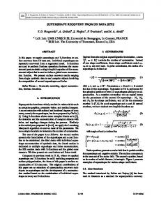
5. An Approach Towards Supporting Dynamic Scene Generation Today, the dynamic generation of HTML pages is a standard functionality of all commercial database systems. This feature has been proven to be a very effective and practical approach to support the (two-dimensional) visualization of information stored within database systems. In this paper, we outline how a similar functionality can be realized to dynamically generate VRML scenes from a database management system (DBMS). This approach overcomes many of the limitations of static VRML scenes, by exploiting the persistence, scalability and security mechanisms of database management systems. In addition, it also provides a direct way to efficiently generate three dimensional visualizations from existing information in the database. In the experiment as shown here, a “Geometry” data type allows, for example, to store all apartments of a building as VRML scenes together with the walls and its floor information along with the its ID. It is possible to select a subset of all apartments with certain properties and merge them in a new scene, e.g., in order to display all apartments that have already been rented to customers.
Figure 6: 3D dynamic data visualization of 3D building data on Web
In Figure 5, a complete building structure is shown using the VRML client application installed as a plug-in with Web browser. Figure 6 shows that how complex 3D data is and to generate the dynamic scene through database onto the Web browser was using the detailed architecture as shown above in the Figure 5. Dynamic scene generation in VRML/X3D using the data from the Oracle Spatial 10g could be done in a way given below: A database connection is used as a statement inside PHP coding. Here are the strings used to connect to the Oracle database: The SQL in this case is quite simple—return all data contained in the table after execution: