The results of scheme validation on the long term at the local scale for the two
sites ... the Project for Intercomparison of Land-surface Parameterization
Schemes ...
Global and Planetary Change 19 Ž1998. 63–86
The land surface parameterization scheme SWAP: description and partial validation Ye.M. Gusev ) , O.N. Nasonova Institute of Water Problems, Russian Academy of Sciences, Moscow, Russian Federation Received 25 August 1997; accepted 9 February 1998
Abstract A full description of the latest version of the land surface parameterization scheme SWAP ŽSoil Water–Atmosphere– Plants. describing the interaction between the land surface and the atmosphere and being oriented on the coupling with atmospheric models is presented. The results of scheme validation on the long term at the local scale for the two sites ŽCabauw, the Netherlands, and Petrinka, Russia. with different climatic and land-surface conditions are given. Analysis of the results shows that SWAP functions well under non-water-stress conditions, but less well during water stress. The possible reasons for discrepancies between the calculated and observed values are discussed. q 1998 Elsevier Science B.V. All rights reserved. Keywords: evapotranspiration; heat and water exchange; snow cover; infiltration; soil freezing
1. Introduction Parameterization of the land surface processes for the incorporation into atmospheric general circulation models ŽGCMs. is one of the most important problems in studying and modelling the climate system the lower boundary of which is the earth’s surface. In solving this problem, the main difficulties are as follows: Ži. the land surface is extremely inhomogeneous Žfrom relatively flat and uniform deserts to regions with complex features of relief and vegetation., Žii. many processes of heat and water exchange occur in a complex and multifactor soil-vegetationrsnow cover-atmosphere system at spatial scales below the spatial resolution of atmospheric models, i.e., at subgrid scales, Žiii. usually it is difficult to provide the land-surface models with parameters for the whole globe and with adequate data for their validation under different natural conditions. The above mentioned problems resulted in the appearance of a great number of so-called Soil-Vegetation– Atmosphere-Transfer ŽSVAT. schemes describing the land surface–atmosphere interactions with different degrees of detail and complexity and operating with more or less reliability in those regions for which they have been developed and calibrated. It is not possible to give a review of the existing SVAT schemes within the
)
Corresponding author. Institute of Water Problems, Russian Academy of Sciences, Novaya Basmannaya St. 10, Box 231, Moscow 107078, Russia. Fax: q7-095-265-1887; e-mail:
[email protected] 0921-8181r98r$ - see front matter q 1998 Elsevier Science B.V. All rights reserved. PII: S 0 9 2 1 - 8 1 8 1 Ž 9 8 . 0 0 0 4 2 - 3
64
Ye.M. GuseÕ, O.N. NasonoÕar Global and Planetary Change 19 (1998) 63–86
scope of the paper. It can only be pointed out that SVAT schemes range from very simple schemes without considering vegetation, for example, Budyko’s ‘bucket’ model—the first parameterization scheme used in a GCM ŽManabe, 1969., to complex models including a large Ž20–50. number of parameters, for example, SiB with 44 parameters ŽSellers et al., 1986., for a detailed description of vegetated surfaces and their distribution within the territory under study. Simple schemes, as a rule, cannot give an adequate description of the land surface–atmosphere interactions. As to the complex models, the main emphasis is usually on the detailed description of the processes occurring during the warm season of a year whereas the cold season processes are treated very schematically. Besides that, such models are usually too large, poorly provided with parameters and require a lot of computer resources. The behavior of different SVAT schemes under the same natural conditions and model parameters, as one can see from the results of comparison of nearly 20 schemes within the frame of the Project for Intercomparison of Land-surface Parameterization Schemes ŽPILPS. initiated in 1992 ŽHenderson-Sellers et al., 1993., may quite differ from each other and from observations. Therefore, the problem of improvement of the existing land-surface schemes and development of new physically based and sufficiently rational Žfrom the viewpoint of providence with parameters and consuming computer resources. models adequately describing the land surface–atmosphere interactions has not been solved yet. The present work represents an attempt to contribute a solution to this problem. The aim of this paper is to present a new physically based model SWAP ŽSoil Water–Atmosphere–Plants., describing the interactions between the land surface and the atmosphere and being oriented on the coupling with atmospheric models. SWAP is a one-dimensional model, based on a system of physical–mathematical equations for the surface energy balance, the water balances of the canopy, the soil root zone and snow cover, and for the heat and water transfer within a soil-vegetationrsnow cover-atmosphere system ŽSVAS.. The distinctive features of SWAP are as follows: Ži. it is a physically based model especially with respect to the description of the processes of the winter–spring period which are usually described very schematically; Žii. in solving the systems of equations, we tried to use analytical methods contrary to the usual practice of the application of numerical ones, that allowed us to avoid many problems associated with solving the numerical equations Žsuch as instability, great consumption of the computer resources and the calculational time and so on.; Žiii. a relatively small number Ž18. of model parameters is needed most of which can be obtained from literature; Živ. when calculating the partition of non-intercepted rainfall into infiltration and surface runoff, the spatial variability of hydraulic conductivity at saturation is taken into account. Relatively simple mathematical formalism and application of the analytical approach make the model compact and sufficiently rational. SWAP has participated in PILPS since Phase 2Ža., ŽChen et al., 1997.. The first version, developed in 1994 and used in PILPS 2Ža., is described in Gusev and Nasonova Ž1997b.. Since then the model has been advanced in its representation of the evaporation from a bare soil, formation of snow cover and drainage, as well as the calculation of some soil and snow parameters. Here we give a detailed description of the latest version and the results of its partial validation on a local scale. For convenience all mathematical symbols are systematized in Appendix A.
2. Model description As mentioned above, the approach used consists of a physically based modelling of heat and water transfer within the SVAS on a local scale throughout the year, with the main emphasis on application of analytical methods. Using an analytical mathematical formalism usually requires the distinction of the main aspects of the phenomena and the neglect of insignificant details. The difficulty is that during different periods of a year, different hydrothermal processes in SVAS dominate, as a result of seasonal variation of heat and water exchange at the land surface. For this reason it is impossible to develop a general, simple and convenient
Ye.M. GuseÕ, O.N. NasonoÕar Global and Planetary Change 19 (1998) 63–86
65
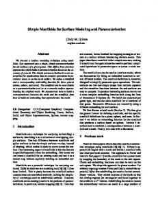
analytical model for a whole year. At the same time it is possible to divide a year into several periods with prevalence of some kind of processes to develop a model for each period and then to link the models into one package allowing one to perform simulations continuously throughout a year and year by year. Such approach has been successfully applied when developing an agrometeorological model which describes the formation of soil water regime for various ecosystems of the steppe and forest steppe zones of the former Soviet Union ŽGusev and Nasonova, 1997a.. In the present work, a year was divided into warm and cold seasons. For each season, a separate analytical model was developed. These two models were then linked as individual blocks into one general model, named SWAP. The scheme of SWAP is given in Fig. 1. The cold season model is used only in the case of the fulfillment of, at least, one of the following conditions: Ž1. the mean daily air temperature is below 08C continuously during several days Žhere, not less than 7 days.; Ž2. the land surface is covered by snow; Ž3. the soil freezing depth is greater than zero.
Fig. 1. Schematic representation of SWAP.
Ye.M. GuseÕ, O.N. NasonoÕar Global and Planetary Change 19 (1998) 63–86
66
It should be noted that in SWAP there is a common technique for the whole year for the calculation of potential evaporation using atmospheric forcings from the lowest atmospheric layer of GCMs. That is why besides the two above mentioned blocks, SWAP includes a block for the calculation of potential evaporation. 2.1. Calculation of potential eÕaporation using atmospheric forcings from the lowest atmospheric layer of GCMs On the basis of meteorological information from the lowest calculational layer of GCMs, used as atmospheric forcings, potential evaporation from the land surface Žsoil or snow. is calculated. Since the lowest layer can be situated at a height of an order of 10 1 –10 2 m from the land surface, the turbulent fluxes and the surface temperature should be calculated taking into account the atmospheric stability. Here, for this purpose we use the main outcome of Monin–Obukhov ŽMO. similarity theory ŽZilitinkevich, 1970; Zilitinkevich and Monin, 1971.. The system of equations for the calculation of potential evaporation is listed below. Ža. The equation for the surface energy balance which includes, along with the common components, the component lIc M representing the heat losses on snowmelt and soil thawing: R n s l E q H q G q lIc M
Ž 1.
Žb. Equations for the heat and water turbulent fluxes at the land surface, defined in terms of MO scaling parameters: H s yT) c p æ rs U)
Ž 2.
E s yq) æ rs U)
Ž 3.
Žc. Equations for the vertical profiles of wind speed U, potential air temperature u and air specific humidity q from the land surface to a reference level Ž z s z a ., which result from the MO theory: Ua æ s U) f U Ž Ž z a y d 0 . rL ) . y f U Ž z 0rL ) .
Ž 4.
ua y us s T) fu Ž Ž z a y d 0 . rL ) . y fu Ž z 0rL ) . q f 2
Ž 5.
qa y qs s q) f q Ž Ž z a y d 0 . rL ) . y f q Ž z 0rL ) . q f 2
Ž 6.
where: L) s
U)2
Ž 7.
æ 2 g Ž T) rTa q 0.61q) .
f 2 s 0.13
z 0 U)
0.45
ž /
Ž 8.
n
u s T Ž 1000rp .
R a rc p
s T Ž 1000rp .
0.288
Ž 9.
It should be noted that without the term f 2 Eqs. Ž5. and Ž6. would be valid from a height of roughness length z 0 to z a , whereas incorporating f 2 allows one to expand the application of the equations to the land surface ŽZilitinkevich and Monin, 1971.. Žd. The equation for net radiation at the land surface: R n s Ž 1 y a . R S x q R L x y s´ Ts4 .
Ž 10 .
To close the system of equations, the air adjacent to the surface is assumed to be saturated, i.e., the surface specific humidity qs is equal to the saturated specific humidity qsat Ž ts . at the surface temperature ts . This assumption is reasonable because the system of equations is intended for the calculation of potential
Ye.M. GuseÕ, O.N. NasonoÕar Global and Planetary Change 19 (1998) 63–86
67
evaporation, i.e., evaporation from wetted surface. This allows one to use the Magnus formula for the air humidity at saturation ŽKhromov and Mamontova, 1974.: qs s qsat Ž ts . s
0.623 P 6.1 p
exp
ž
17.1ts 235 q ts
/
Ž 11 .
The universal functions, used in Eqs. Ž4. – Ž6., can be determined Žunder æ s 0.43. empirically as follows ŽZilitinkevich, 1970.:
fU
z
z
ž / ž / ž s fu
L)
L)
s fq
z L)
°lnŽ zrL . q 10Ž zrL / s~¢ln0.25< zrLq 1.2< Ž zrL . )
)
.
)
y1r3
)
,
if zrL ) ) 0
,
if y0.07 F zrL ) F 0
,
if zrL ) - y0.07
Ž 12 .
Albedo is calculated by Ghan et al. Ž1982.:
as
½
a s q Ž a sn y a s . '0.1 P Sn a sn
, ,
if Sn - 10 if Sn G 10
Ž 13 .
here, the snow free surface albedo a s we determine by:
a s s a vg Ž 1 y C Ž L . . q a soilC Ž L .
Ž 14 .
where Ž1 y C Ž L.. represents the fractional vegetation cover, C Ž L. can be approximated by the following expression:
C Ž L . s exp Ž y0.45L .
Ž 15 .
This expression was derived from experimental data on evaporation from different types of vegetation which were obtained by heat and water balance methods in different regions of the Former Soviet Union ŽFSU. ŽBudagovskiyi and Dzhogan, 1980; Budagovskiyi, 1986; Busarova and Shumova, 1987.. The potential evaporation depends, in particular, on the relation between net radiation R n and ground heat flux G. During warm seasons, for a time step not less than one day, G is nearly an order of magnitude less than R n Žfor example, Pavlov, 1979., i.e., G is relatively small in its contribution to potential evaporation Žespecially for the vegetated surfaces.. For this reason we estimate G approximately using the empirical expression for G derived from the appropriate information given in Budyko Ž1956.. For the cold season when the surface temperature is ts F 0 and in the absence of liquid fraction in snow cover Ž‘dry snow’. G can be calculated in the following manner: Gs
ts hrl1 q jrl2
Ž 16 .
If snow cover has liquid water Ž‘wet snow’., which freezes at ts F 0, we use the simple parameterization for G: G s l1
ts hr2
Ž 17 .
In the case of soil thawing Ž ts ) 0., G is calculated as follows: Gs
ts
j th rl3
Ž 18 .
Solution of the described system of equations gives us the turbulent heat flux from the wetted surface, i.e., potential evaporation E PE s E, and the temperature of this surface. In doing so, the values of parameters z 0 and d 0 are specified for snow cover Žif any. which allows us to calculate potential snow evaporation and the surface
Ye.M. GuseÕ, O.N. NasonoÕar Global and Planetary Change 19 (1998) 63–86
68
temperature of snow cover. In the absence of snow cover, z 0 and d 0 are taken not for the given type of vegetation, but for a hypothetical rough surface Ž d 0 s 0, z 0 s 0.05 m., that allows the calculation of potential evaporation from this surface. The latter is necessary to follow semi-empirical theory by Budagovskiyi Ž1981. which deals with potential evaporation from the land surface and potential transpiration, i.e., transpiration by full plant cover under unlimited water supply, when calculating the actual values of transpiration and soil evaporation during the warm season Žsee Section 2.2.3.. 2.2. Description of the processes occurring during the warm season This block includes a description of the following processes ŽFig. 1.: interception of precipitation by the canopy and evaporation of intercepted precipitation, partitioning non-intercepted precipitation into infiltration and surface runoff, transpiration, soil evaporation, water exchange at the lower boundary of the soil root zone, changes in the soil root zone water storage and formation of the surface energy balance. 2.2.1. Rainfall interception and eÕaporation of intercepted precipitation To estimate the intercepted precipitation we use the bucket concept, i.e., the canopy is modeled simply as a bucket, or reservoir, of fixed capacity Wcmax that can be filled by precipitation P and emptied by evaporation EC . While the bucket is not full it is assumed that all precipitation can be intercepted by the canopy. In this case, the change in the canopy water storage Wc is calculated using the following water balance equation: dWc dt
s P y EC ,
if Wc - Wcmax
Ps s 0,
Ž 19 .
When the bucket is full ŽWc s Wcmax . the excess precipitation is assumed to leave the canopy and reaches the soil surface in the form of drainage Ps : if Wc s Wcmax and P y EC ) 0
Ps s P y EC ,
Ž 20 .
The rate of evaporation of intercepted precipitation EC is calculated under the following assumptions: Ži. all intercepted water is concentrated at the surface of the canopy which is fully wetted, Žii. evaporation occurs at the rate which equals the potential evaporation E PE . This allows us to simplify the calculational algorithm for EC : EC s
½
E PE 1 y C Ž L . 0
, ,
if Wc ) 0 if Wc s 0
Ž 21 .
2.2.2. Calculation of infiltration rate with taking into account the spatial Õariability of hydraulic conductiÕity at saturation The infiltration rate I is calculated on the basis of the relationship between the precipitation rate Ps and the infiltration curve I P s I P Žt ., which characterizes the rate of infiltration under pressure. The infiltration curve can be derived from a modification of the Green–Ampt equation ŽGusev, 1989., according to which the infiltration rate under pressure can be written as:
ž
Ip s k 0 1 q
Hk zw
/
Ž 22 .
Here, the maximum value of the soil effective capillary potential is determined as ŽGusev, 1993.: Hk s
f0
Hy`
k
ž / k0
df
Ž 23 .
Ye.M. GuseÕ, O.N. NasonoÕar Global and Planetary Change 19 (1998) 63–86
69
When calculating the integral in Eq. Ž23. one can use dependencies of k and f on the volumetric soil moisture W. In particular, here, we use the relationship by Clapp and Hornberger Ž1978.: k s k0
2 Bq3
W
ž /
, f s f0
Wsat
W
yB
ž /
Ž 24 .
Wsat
Combining Eq. Ž22. together with the water balance equation of wetted zone and supposing that soil water content before wetting front is approximately equal to field capacity, we can find a solution to the problem of the dynamics of I Žt .. Simplification of this solution results in the following expression for the infiltration curve Žwhich is similar in structure to the infiltration equation derived by Philip, 1957.:
(
I P s k 0 q 0.5 2 k 0 H k r w DWty1 pr
Ž 25 .
where DW is the difference between soil porosity and field capacity. The time interval tpr is calculated from the beginning of current rainfall. If there is an interval, exceeding 24 h, without rainfall, tpr is set to be zero and for the next rainfall tpr should be calculated from the very beginning. It should be noted that spatial variability of the coefficient of hydraulic conductivity at saturation k 0 is high. Thus, in Gusev Ž1993. it is pointed out that, according to observations, k 0 may differ within order of several meters. Therefore, even for a small area the spatial variability of k 0 should be taken into account when calculating water infiltration into the soil. To a first approximation, the spatial variability of k 0 can be characterized by its standard deviation s k from its mean value k 0 . Given the function of distribution of k 0 , one can calculate the mean value of the infiltration rate for heterogeneous areas. Here, as a first approximation, k 0 is assumed to be uniformly distributed on some interval from a to b. This assumption allows the derivation of analytical expression for the areally averaged infiltration rate:
°2 A
1
3
~
k0 )
k 03r2 < q
A2
a
2
k0)
b
k 02 < q Ps A 2 k 0 < a
I s Ps
¢ A1 s
2 A1 3
b
k 03r2 < q a
(
A2 2
if a - k 0 ) F b
,
if k 0 ) F a
,
if k 0 ) ) b
Ž 26 .
b
k 02