328
IEEE GEOSCIENCE AND REMOTE SENSING LETTERS, VOL. 5, NO. 3, JULY 2008
Wavelet-Based Technique to Extract Convective Clouds From Infrared Satellite Images Bhupendra A. Raut, Student Member, IEEE, R. N. Karekar, and Dileep M. Puranik
Abstract—Extraction of all cumuliform clouds from infrared satellite images is important for cloud studies. Existing methods have focused on extracting only the cumulonimbus clouds. Over monsoon Asia, warm cumulus and cumulus congestus clouds are a large fraction of total cumuliform clouds and are covered by cirrus. An extraction method based only on brightness temperatures (BT) is not sufficient for the detection of these cumuliform clouds. In this letter, a new cloud extraction technique based on spatial characteristics of the convective clouds is presented. The à trous wavelet transform (ATWT) is shown here to successfully extract both shallow and deep convective clouds. The depression in BT caused by the cold cloud tops corresponds to negative wavelet components found by the ATWT. Index Terms—À trous wavelet transform (ATWT), infrared (IR) satellite data, monsoon, warm convective clouds. Fig. 1. Schematic of clouds illustrating the concept of depression in BT (dBT) with clouds of different scales.
I. I NTRODUCTION
D
URING the southwest monsoon season, a tropical easterly jet (TEJ) persists in the upper troposphere over the Indian region. The TEJ blows the anvils of cumulonimbus to great distances, covering a very large area of the region with cirrus. The cirrus obscures the shallow convective clouds that make a major contribution to rainfall. To study this cloud scenario over the Indian (and Asian) region during the southwest monsoon, infrared (IR) satellite data are preferred because of the day as well as nighttime availability. Good spatial and temporal resolution of the present-day geostationary sensors is an added advantage. Although all cumuliform clouds are important and although cumulonimbus fraction in total cumuliform cloud cover is very small [1], the focus has been on extracting cumulonimbus. The methods to do so include the use of brightness temperature (BT) thresholds [2], gradients [3], and the use of water vapor channel in addition to IR [4]. In the monsoon region, the cirrus cover meets both the criteria of low BT [2] and significant gradients [3]. The result is misclassification of cirrus as cumuliform and the often missing cumulus and cumulus congestus. The objective of this letter is to present a robust method of extraction of all cumuliform clouds in IR satellite data in the presence of cirrus and other clouds. The dataset is from Meteosat-5 satellite with an image resolution of 5 km.
Manuscript received August 6, 2007; revised January 3, 2008. This work was supported by the Indian Space Research Organization and was conducted at the University of Pune. The authors are with the Department of Atmospheric and Space Sciences, University of Pune, Pune-411 007, India (e-mail:
[email protected];
[email protected]). Digital Object Identifier 10.1109/LGRS.2008.916072
Meteosat-5 is positioned at 63◦ E. The region covered by the data is 4◦ N to 33◦ N, 65◦ E to 94◦ E. II. E XTRACTION S CHEME Fig. 1 shows the schematic model of small cumuli (5 km size, 3–5 km height), cumulus congestus (10–15 km size, 5–6 km height), the rare cumulonimbus (20–40 km size, 10–16 km height), and extensive cirrus (hundreds of kilometers in size). Their BTs decrease with an increase in height. To extract these cumuliform clouds, the selected method should separate clouds including cirrus by size or scale. The extracted quantity would be the depression of BT (dBT) from the background. Wavelet transforms (WTs) are a class of tools that perform scale analysis. At every stage, the image scale doubles, and objects of up to double in size are successively revealed. However, typical WTs shrink (i.e., decimate) the images at larger spatial scales. Hence, in the cloud separation study, useful information would be lost should the extracted cloud feature change its size or shape. Hence, a nondecimating WT is required. The à trous wavelet transform (ATWT) [5], [6] is a nondecimating, dyadic algorithm in which the image retains its size at all stages. The ATWT allows for multiscale analysis. Translation invariance is maintained. Since information is not lost in decimation, the wavelet components are separately interpretable as radiance changes at each scale. The optimal scaling function for analysis is the B-3 spline [7]. The convolution mask used here is hB3(l) = {0.0625, 0.25, 0.375, 0.25, 0.0625}. Puranik and Karekar [8] used the ATWT for separating structures in thunderstorms in advanced microwave sounding unit-B data. To explain the working of the ATWT algorithm, a onedimensional signal is used in Fig. 2, which shows one such
1545-598X/$25.00 © 2008 IEEE
RAUT et al.: WAVELET-BASED TECHNIQUE TO EXTRACT CONVECTIVE CLOUDS
329
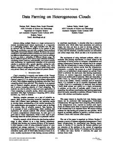
Fig. 2. Illustration of wavelet transform (WT) for 1-D data. C0 is given as input, and remnant Ci after each step is shown. Positive part of the vertical axis shows input (BT) signal at each step, and negative part shows corresponding WT (dBT) output.
signal C0 . This signal consists of small and large-scale BT variations. This is transformed according to the following scheme: Ci (k) = Σh(l) Ci−1 (k + 2i−1 l)
(1)
Wi (k) = Ci−1 (k) − Ci (k).
(2)
The h(l) is derived from the scaling functions associated with the à trous wavelet. On being transformed, the first stage ATWT shows small-scale (i.e., high spatial frequency) variations W1 (see negative part of the vertical axis in Fig. 2). For the next stage ATWT, the remnant of the first stage, namely, C1 = C0 − W1 , is given as input, and W2 is computed. Remnant for the next stage C2 is C1 − W2 . As clouds are colder than the background in IR satellite images, only negative values are considered to represent clouds. The negative wavelet components show lack of radiance received at that point. Negative values of wavelet components (shown at the negative end of the vertical axis in Fig. 2) indicate the BT depression of the pixel from its immediate larger background. That is, wavelet component of ith scale is depression of BT from the (i + 1)th scale. Consequently the sum of all these wavelet components gives combined dBT at that pixel from the common largest background. In the present study, the ATWT was computed for Meteosat-5 IR images of 640 × 640 pixels. Scales 1, 2, 3, and 4 refer to structures of 1, 2, 4, and 8 pixels, respectively, i.e., of 5, 10, 20, and 40 km in size, respectively. A typical convective system has spatial variations at scales smaller than 40 km. Thus, by summing all the wavelet components to scale 4, all clouds smaller than 40 km (namely, thunderstorm-sized features) can be seen together. Scales 1, 2, 3, and 4 are merged and called WT4 image. However, some cumulonimbus are embedded in cirrus; their dBT is from a cirrus background. To get the difference between cirrus and the surface, the ATWT is calculated up to scale 7 (320 km). Higher scales correspond either to very large synoptic systems or to the surface. For every non
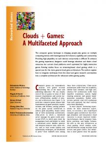
Fig. 3. Example showing (a) Meteosat BT image from July 23, 2006, at 1130 IST, (b) WT4 image of the same scene, (c) visible channel (VIS) image, and (d) water vapor (WV) absorption channel image. VIS and WV data are in digital counts (DC). Latitudes and longitudes are marked on panel (b).
zero pixel in WT4, all the dBTs up to scale 7 are summed. This ensures that total dBT for every pixel is depression of BT from a common background. Thus, this dBT is the temperature difference between cloud top and land or sea surface dBTtotal = dBT1 + dBT2 + · · · + dBT7 .
(3)
Significant wavelet components at all scales are selected using thresholds [6]. The thresholds for every scale can be written as n times standard deviation. The higher the n, the more warm clouds are rejected. To extract warm clouds, the number of iterations of ATWT over the remnant signal C7 can be increased. These two choices affect the result. Experimentation has found that n = 2 and two iterations are the optimal choice. This is revealed by comparison between WT4 and the IR, visible light (VIS), and water vapor absorption (WV) images. ATWT still includes cirrus streaks (long, thin structures) within the convective class. The cirrus is removed by “opening” [9]. Opening is generally useful in removing narrow isthmuses and to eliminate thin protrusions. Here, we used an elliptical filter. III. R ESULTS AND D ISCUSSION A. Case Study The technique has been tested for a large number of IR-visible image pairs. A case is presented to show extraction of cumuliform clouds in IR data. Fig. 3(a) shows the IR satellite image of July 23, 2006 at 1130 IST and Fig 3(b) shows WT4 for the same data. For comparison, Fig. 3(c) and (d) are the VIS and WV images of the same scene. As mentioned earlier, presence of the cirrus dominates the lower clouds in the IR image. To some extent, the VIS image helps clear the view.
330
In Fig. 3, clouds marked A and B are isolated convective clouds, which are nicely separated in the WT4 image. The system marked C in Fig. 3 is a convective cloud cluster. Overshooting convective tops are clearly seen in the VIS and the WV images. These are nicely separated in WT4. In the North Bay, cumuliform clouds near region D are seen in the VIS image, but the WV image shows cirrus cover. These are separated from cirrus using their characteristic small-scale BT variations in the IR image. However, region E is totally covered by thick and smooth cirrus. Thus, no small-scale features are captured in the IR image.
B. Remarks The ATWT-based method successfully extracts all cumuliform clouds from the IR satellite images. This extraction method provides good results even when a convective cloud (overshooting cumulonimbus tops) is a part of the larger cloud cluster or when warm cumuliform clouds are beneath the semitransparent cirrus. Clouds totally obscured by thick cirrus cannot be detected. ATWT also captures some unwanted structures, like cirrus streaks. These can be removed using different morphological filters. One of the advantages of the WT4 image is its clean background. This would be very useful in computing cloud motion vectors. Thus, it is better to use the ATWT to separate shallow and deep convective clouds from IR images.
IEEE GEOSCIENCE AND REMOTE SENSING LETTERS, VOL. 5, NO. 3, JULY 2008
ACKNOWLEDGMENT EUMETSAT is acknowledged for providing the Meteosat-5 data. Comments of the two reviewers were useful to improve the quality of the manuscript. R EFERENCES [1] R. H. Johnson, T. M. Rickenbach, S. A. Rutledge, P. E. Ciesielski, and W. H. Schubert, “Trimodal characteristics of tropical convection,” J. Clim., vol. 12, no. 8, pp. 2397–2418, Aug. 1999. [2] P. A. Arkin, “The relationship between fractional coverage of high cloud and rainfall accumulation during GATE over the B-scale array,” Mon. Weather Rev., vol. 107, no. 10, pp. 1382–1387, Oct. 1979. [3] R. A. Adler and A. Negri, “A satellite infrared technique to estimate tropical convective and stratiform rainfall,” J. Appl. Meteorol., vol. 27, no. 1, pp. 30–51, 1988. [4] S. Tjemkes, L. van de Berg, and J. Schmetz, “Warm water vapour pixels over high clouds as observed by METEOSAT,” Beitr. Phys. Atmos., vol. 70, no. 1, pp. 15–21, 1997. [5] M. J. Shensa, “Discrete wavelet transforms: Wedding the á trous and Mallat algorithm,” IEEE Trans. Signal Process., vol. 40, no. 10, pp. 2464–2482, Oct. 1992. [6] J.-L. Starck, F. Murtagh, and A. Bijaoui, “The wavelet transform,” in Image Processing and Data Analysis: The Multiscale Approach. Cambridge, U.K.: Cambridge Univ. Press, 1998, ch. 1, pp. 21–24. [7] M. Unser and T. Blu, “Wavelet theory demystified,” IEEE Trans. Signal Process., vol. 51, no. 2, pp. 470–483, Feb. 2003. [8] D. M. Puranik and R. N. Karekar, “Classification of thunderstorms over India using multiscale analysis of AMSU-B images,” J. Appl. Meteorol., vol. 43, no. 4, pp. 595–611, Apr. 2004. [9] R. C. Gonzales and R. E. Woods, “Morphological image processing,” in Digital Image Processing. Upper Saddle River, NJ: Pearson Education, 2002, ch. 9, pp. 550–554.