An ASAE Meeting Presentation Paper Number: 052099
A DESIGN FLOOD FORECASTING SYSTEM BASED ON THE CRITICAL STORM DURATION FOR HIGHWAY DRAINAGE FACILITIES M. S. kang, Ph. D Research Associate, Dept. of Biosystems Engineering, Auburn Univ., Auburn, AL 36849
J. H. Goo, Ph. D Chief, Affiliation, GIS Enterprising Center, KICT, Gyonggi-Do, Korea
S. W. Park, Ph. D Professor, Dept. of Rural System Engineering, Seoul National Univ., Seoul, Korea
Y. G. Her, MS Engineer, Dongbu Engineering Co., Ltd., Seoul, Korea
K. H. Yoo, Ph. D Professor, Dept. of Biosystems Engineering, Auburn Univ., Auburn, AL 36849
Written for presentation at the 2005 ASAE Annual International Meeting Sponsored by ASAE Tampa Convention Center Tampa, Florida 17 - 20 July 2005 Abstract. Highway culverts are installed to safely drain the design peak runoff and the dimensions are to be determined based on the estimated design peak runoff and hydraulic computations. The critical storm duration and peak discharge according to the rainfall distribution type, the position of peak rainfall intensity, and frequency were evaluated by seven hydrological models. The hydrological models were tested with field data measured from two small watersheds. The hydrological parameters were defined using the GIS data of the watersheds. And the results from different peak runoff equations and hydrological models were found that the simulated for runoff hydrographs were comparative to the observed hydrographs. Hydraulic designs of highway culverts, thirty five drainage watersheds along renovating segments of Highway No. 39 in Korea, were studied to define the optimum dimensions and hydraulic variables for the design peak runoff. This study may also be applicable to the design of highway drainage systems for areas with future and postulated land uses and new development. Keywords. Design peak runoff, Critical storm duration, Highway culverts, Hydrograph, GIS. The authors are solely responsible for the content of this technical presentation. The technical presentation does not necessarily reflect the official position of the American Society of Agricultural Engineers (ASAE), and its printing and distribution does not constitute an endorsement of views which may be expressed. Technical presentations are not subject to the formal peer review process by ASAE editorial committees; therefore, they are not to be presented as refereed publications. Citation of this work should state that it is from an ASAE meeting paper. EXAMPLE: Author's Last Name, Initials. 2005. Title of Presentation. ASAE Paper No. 05xxxx. St. Joseph, Mich.: ASAE. For information about securing permission to reprint or reproduce a technical presentation, please contact ASAE at
[email protected] or 269-429-0300 (2950 Niles Road, St. Joseph, MI 49085-9659 USA).
Introduction The design of a highway drainage facility requires the determination of discharge-frequency relationships. Some facilities require a determination of a momentary peak flow rate while others require a runoff hydrograph providing an estimate of runoff volume. The momentary peak flow rates are most often used in the design of bridges, culverts, roadside ditches, and small storm sewer systems. These small-scale engineering works are sensitive to the design flood. Estimation of design flood is one of the important components of planning and management of water and land resources for sustainable development and effective implementation of soil and water conservation practices for a watershed. Information on flood magnitudes and their frequencies is needed for design of various structural and non-structural measures of soil and water conservation such as check dams, spillways, ponds, agricultural drainage systems, flood plain zoning, economic evaluation of flood protection projects etc (Kumar et al., 2003). In particular, estimates of floods on small catchments are required for a number of purposes, including design of soil conservation and road-crossing structures (Titmarsh et al., 1995). The estimation of peak flows on small to medium-sized rural drainage basins is probably the most common application of flood estimation as well as being of greatest overall economic importance. It is not possible to define precisely what is meant by small and medium sized, but upper limits of 25 km2 and 500 km2, respectively, can be considered as a general guidline. Hundreds of different methods have been used for estimating floods on small drainage basins, most involving arbitrary formulas. The three most widely used types of methods are the rational method, the U.S. Soil Conservation Service (NRCS) Method, and regional flood frequency methods (Maidment, 1992). However, the choice of method depends on the applicable design criteria and availability of data. In spite of the widespread use of the design storm concept, the basis for numerous elements of the design storm method is not documented (Levy et al., 1999). The duration of a design storm is one such element. Most peak discharge design methods use a storm duration of either 24-h period or the time of concentration (Levy et al., 1999). However, information on the actual intensity distribution within the 24-h period is lacking and practitioners resort to design storms for sub-daily precipitation distribution. A source of available precipitation data is intensityduration-frequency (IDF) precipitation data. However, these uniform intensities are developed only from maximum intensities within storms, and thus represent incomplete storms. It is also difficult to determine design floods due to lack of hydrological data and the area’s extreme floods. For estimation of design floods of selected exceedance probability, there is a critical duration that gives the maximum peak discharge. Where the design procedure does not specify the duration, floods should be calculated from design rainfall events of several durations and the selected probability. The flood peaks are plotted against rainfall duration, and the design peak discharge and critical duration are obtained from the peak of a smooth curve drawn through the plotted points (Maidment, 1992). In case of Korea, after Disaster Impact Assessment (DIA) Program was developed and implemented, wide variety of hydrological data are estimated by introducing the concept of critical storm duration to calculate the stormwater impoundment as an alternative of increasing runoff due to wide-spread land development. The critical storm duration changes due to variation of hydraulic structures, drainage characteristics, temporal distribution of design rainfall events, return periods, and surface runoff. In this study the methods of estimating the proper peak runoff to design the highway drainage facilities are proposed to determine the design flood by comparing and analyzing the peak
2
runoff based on the rainfall distribution and duration. The methods of determining the critical storm duration of a design rainfall which cause the peak runoff of the runoff hydrograph are studied by analyzing the rainfall-runoff relationship using the various runoff models and observed data. And the hydraulic design of highway culverts is proposed to define the dimensions and hydraulic variables of the optimal culverts of a selected type for the design peak runoff.
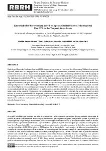
Methodology Study Area and Data Availability Two small watersheds in Korea, the Baran (HP#6) watershed and Banweol (WS#1) watershed, were selected to evaluate the prediction capacity of the hydrologic models used in this study. The Baran watershed, 2,979 ha in size, is located about 8 km west from Suwon city in Kyunggi province (Figure 1). Hydrologic data for the watershed have been collected since 1996 as a part of an environmental monitoring and assessment study for the agro-ecological systems (Park et al., 2000). The watershed monitored by the gauging station HP#6 has a drainage area of 384.8 ha and is located in the headwaters of the Baran River, draining into the Namyang sea dike. The landuses of the watershed are mostly forest (51 %), followed by urban (20 %), paddy (19%), and the remainder consisting of upland and water (10 %). The geomorphological characteristics of flow length, slope, and shape coefficient of the watershed are 3.1 km, 1.5 m/km, and 1.56, respectively.
(HP#6)
(WS#1)
Wate rshed outlet
(Highway No. 39)
Figure 1. Selected watersheds and Highway No. 39 used as a case study.
3
The WS#1 watershed is 274 ha and has land use characteristics with 41 % paddy land, 27 % upland, 29 % forest, and 8 % farmstead. Its soil and topologic characteristics are similar to those of HS#6 with the exception of the watershed shape. A monitoring station equipped with two float- and pressure-type water level gauges is located at the channel outlet of watershed HP#6 and WS#1. The measured water levels were converted to stream flow rates using the rating curves developed for the sites. Thirty-five drainage culverts in circular, single rectangular, and multiple rectangular types, along the renovating segments of Highway No. 39 nearby the two watersheds were selected (Figure 1). The watershed areas of these drainage culverts vary from 1.0 to 223.0 ha. The hydrological parameters were defined using the Geographical Information System (GIS). GIS data were incorporated to create, retrieve, and evaluate the databases for highway drainage design. GIS was capable of accurately extracting the geographic and hydrologic characteristics from existing databases as input for the hydrologic models.
Time of Concentration Rainfall distribution includes maximum rainfall intensities for the selected design frequency arranged in a sequence that is critical to generate the peak runoff. The length of the most intense rainfall period contributing to the peak runoff rate is related to the time of concentration (Tc) for the watershed. The Tc represents the time it takes for runoff to travel to a point of interest from the hydraulically most distant point (Maidment, 1992). The Tc of an urban basin is usually obtained by empirical equations or by using equations established for rural basins. These equations are useful, as a first approximation, but do not satisfactorily describe all local conditions (Campana and Tucci, 2001). For rural drainage basins, Tc is normally calculated as the watershed length divided by the velocity determined by hydraulic formulas or tabulated values. For rural drainage basins, Tc is generally estimated by an empirical formula. In this study hydraulic and empirical formulas for calculating the design values of Tc are used as follows: Kirpich, Rizha, Kerby, Califonia, and KICT formulas.
Design Storm The frequency of rainfall of various intensities and durations is used in the hydrologic design of structures that control storm runoff and floods, such as highway culverts. Rainfall intensityduration-frequency (IDF) curves allow calculation of the average design rainfall intensity for a given exceedance probability over a range of durations. IDF curves are available form Korea Institute of Construction Technology (KICT, 2000). In order to estimate design floods of different return periods, IDF curves at the city of Suwon that were described mathematically to facilitate calculations were used. The peak runoff varies according to the time distribution of the rainfall so that the value of the peak runoff can vary according to the ideal rainfall type. In this study, Several rainfall distribution models such as Mononobe, Huff, and Yen and Chow (Triangle and Trapezoid type) methods were selected to estimate the peak runoff.
4
Design Flood Estimation and Designing Culverts Small watershed designs usually involve the use of either the rational method or a unit hydrograph procedure to predict peak flows at various places for a given design rainfall and duration (Bedient and Huber, 2002). The hydrologic models simulate peak runoff and design storm hydrographs from commonly applying methodologies and models. Design floods according to the rainfall distribution types and rainfall storm durations were evaluated using seven hydrologic models as follows: rational method, Kajiyama, modified Kajiyama, USDA Soil Conservation Service (SCS), WFR Paddy, Clark, and Nakayasu. The hydrological models were tested with field data from the two small watersheds mentioned before. The hydrological parameters were defined by using the GIS system. And the results from different peak runoff equations and hydrologic models were found to simulate runoff hydrographs that are comparative to the observed. . AASHTO method was applied for determining the dimensions of culverts for hypothetical design storms that result from the changes in topography and land uses at the thirty-five drainage watersheds in this study
Results and Discussions Rainfall Distribution and Critical Storm Duration The values of the parameters for the rainfall distribution models (Yen and Chow) were obtained from KICT (2000). For the Huff model, hourly rainfall records for the period from 1964 to 2000 were obtained from the Suwon weather station. Figure 2 shows Huff curves for the second and third quartile storm developed with the Suwon precipitation data (storms > 12.7 mm). The greatest precipitation intensity occurs in the first quartile.
100%
100%
50
80%
80%
90%
70
70%
80% 90%
80%
Dimensionless rainfall (%)
Dimensionless rainfall (%)
90%
60%
90%
60%
50%
40%
40% 30%
70%
60% 60%
70 50%
40%
10%
20
40%
30
30%
30% 10
20%
20% 50
20%
10%
10%
0%
0% 0
10
20
30
40
50
60
70
Dimensionless time (%)
(2nd quartile storm)
80
90
100
0
10
20
30
40
50
60
70
80
90
100
Dimensionless time (%)
(3rd quartile storm)
Figure 2. Huff curves using Suwon precipitation data (storms > 12.7 mm).
To select the rainfall distribution model for the design flood, the peak runoff and the critical storm duration according to the need of rainfall distribution models were estimated by the Clark model at the selected watersheds. Typical return period design criteria for the highway culverts for intermediate traffic load in Korea is 25-yr.
5
Figure 3 shows the peak runoff and critical storm duration according to the rainfall distribution models for the 25-yr return period. The Mononobe model resulted in a divergence and the Huff model showed the highest peak runoff. Thus, the Huff rainfall distribution model was selected to estimate the design peak runoff.
160
90
Mononobe
Mononobe
80
140
70
Peak runoff (m /sec)
3
100
3
Peak runoff (m /sec)
120
80
60
Huff Triangular
40
60
50
40
Huff
30
Triangular Trapezoid
20
Trapezoid Uniform
Uniform
20
10
0
0 0
200
400
600
800
1000
1200
1400
1600
0
200
400
600
800
Duration (min)
1000
1200
1400
1600
Duration (min)
(HP#6)
(WS#1)
Figure 3. Critical storm duration and peak runoff of rainfall distribution models.
Sensitivity Analysis Figure 4 shows the changes of the peak runoff and critical storm duration by the Huff model for the 25-yr return period for different CN values.
70
45
40
CN = 89
60
CN = 90
CN = 83 50
CN = 85
35
CN = 80
CN = 78
Peak Runoff (m3/sec)
Peak Runoff (m3/sec)
30
CN = 69
40
CN = 60 30
CN = 71 25 CN = 63 20
15
20 10
10 5
0
0
0
200
400
600
800 Time (min)
(HP#6)
1000
1200
1400
1600
0
200
400
600
800 Time (min)
1000
1200
1400
1600
(WS#1)
Figure 4. Critical storm duration and peak runoff for different CN values (by the Huff model).
Design Flood The results from different peak runoff equations and hydrologic models were found to simulate runoff hydrographs that are comparative to the observed hydrographs. Figure 5 and 6 show the peak runoff rate from each formula and the comparison of the observed and the simulated peak runoff from each hydrologic model, respectively.
6
100 90
Peak runoff (m3/s)
80 70 60 50 40 30
National method(HP#6) Kajiyama(HP#6) Mod._Kajiyama(HP#6) National method(WS#1) ji ( S 1)
20 10 0 0
20
40
60
80
100
120
Frequency (year)
Figure 5. Peak runoff rate by peak runoff equations.
70
45 SCS WFRpaddy Clark Nakayasu WFRpaddy Clark Nakayasu SCS
R2 = 0.955
SCS
R = 0.9721
Clark
R2 = 0.9686
Nakayasu
2
40
35
WFRpaddy
30
2 R = 0.8861 Nakayasu
3
3
Simulated (m /s)
50
R2 = 0.9376
Simulated (m /s)
60
2 R = 0.8738 SCS R2 = 0.8994 Clark R2 = 0.8845 WFRpaddy
SCS WFRpaddy Clark Nakayasu WFRpaddy Clark Nakayasu SCS
40
30
25
20
15 20 10 10 5
0
0 0
10
20
30
40 3
Observed (m /s)
(HP#6)
50
60
70
0
10
20
30
40
50
60
70
3
Observed (m /s)
(WS#1)
Figure 6. Comparison of the observed and the simulated peak runoff by hydrologic models.
Design Flood for Culvert Hydrologic models for estimating the design flood were used to design thirty-five drainage culverts along the renovating segments of Highway No. 39 in Korea. The peak runoff and hydraulic design parameters, and culvert dimensions were determined for each of the thirty five structures. The results showed that the new peak runoff was generally smaller than the results of the existing design peak runoff data. The peak runoff from the empirical equations was higher than the results of the hydrologic models. Figure 7 shows comparison of the results of
7
calculated peak runoff by the peak runoff equations for 25-yr through 500-yr return periods. And Figure 8 shows peak runoff considering the critical storm duration according to the return periods. The Huff rainfall distribution model and Clark hydrologic model were applied to estimate the peak runoff with the critical storm durations.
100
Rat i onal met hod 25
Rat i onal met hod 50
Rat i onal met hod 100
Rat i onal met hod 500
Kaj i yama 25
Kaj i yama 50
Kaj i yama 100
Kaj i yama 500
Mod-Kaj i yama 25
Mod-Kaj i yama 50
Mod-Kaj i yama 100
Mod-Kaj i yama 500
90
80
70
Peak runoff (m 3/s)
60
50
40
30
20
10
0 0
10
20
30
40
50
60
70
80
90
100
Pract i cal desi gn runof f ( m3/ s)
Figure 7. Comparison to the results of calculated peak runoff from peak runoff equations.
30
10 9
50year 50year
25 25year
25year
7
20 5year
3
6
Peak Runoff (m /sec)
3
Peak Runoff (m /sec)
8
5year
5 4 3 2
15
10
5
1 0
0 0
200
400
600
800
1000
1200
1400
Time (min)
(DR#7)
0
200
400
600
800
1000
1200
1400
Time (min)
(DR#9)
Figure 8. Critical storm duration and peak runoff according to frequency types.
Hydraulic design of highway culverts American Association of State Highway and Transportation Officials (AASHTO) method defined the dimensions and hydraulic variables of the optimal culverts of a selected type for the given design runoff. AASHTO method was applied for determining the dimensions of culverts for hypothetical design storms that result from the changes in topography and land uses at the thirty-five drainage watersheds in this study. It is possible to incorporate the AASHTO model with GIS data and to design a road through the areas to be developed in the near future. Table
8
1 represents the comparison of culvert sizes from practical design and the AASHTO method at major drainage watersheds. Table 1. Comparison of selected culvert sizes practical mentioned in Korea and determined by the AASHTO method.
Box and culvert size (m) Station
Qd (m3/sec)
Total cross sectional area of flow (m2)
(a)/(b)
Practical Method
AASHTO Method
Practical Method (a)
AASHTO Method (b)
(%)
DR#04
49.70
[email protected]×3.5
[email protected]×2.0
24.50
15.00
61.2
DR#07
16.60
2.5×2.5
[email protected]×1.5
6.25
6.00
96.0
DR#09
95.60
[email protected]×2.5
[email protected]×2.5
22.50
22.50
100
DR#10
92.83
[email protected]×3.0
[email protected]×3.0
18.00
18.00
100
DR#31
12.67
2.5×2.0
[email protected]×1.5
5.00
4.50
90
Conclusion Several design methods are available to determine design flow and drainage structure sizing. Based upon a review of the government requirements and appropriate engineering judgment regarding the particular watershed and drainage structures, the engineer should select the appropriate design methods. Upon completion of a drainage facility design, careful consideration should be given to the proposed installation conditions of the drainage facilities. The results of this study support a conclusion that the results contribute significantly to rationalizing the estimation of design peak runoff, and to simplifying the tedious processes of designing highway culverts. This research is also applied to the design of highway drainage systems for areas with future and postulated land uses and new development.
Acknowledgements Acknowledgements, if any, are placed here under a Heading 2.
References American Association of State Highway and Transportation Officials (AASHTO) Drainage Manual. 1990. AASHTO Task Force on Hydraulics and Hydrology.
9
Bedient, P. B., and W. C., Huber. 2002. Hydrology and Floodplain Analysis, Third Edition. Prentic-Hall, Inc. Bonta, J. V. 2001. Characterizing and Estimating Spatial and Temporal Variability of Times Between Storms. Transactions of the ASAE 44(6): 1953-1601. Bonta, J. V. 2004. Development and Utility of Huff Curves for Disaggreaging Precipitation Amounts. Applied Engineering in Agriculture 20(5): 641-653. Campbell, M. D. 1991. The lower limit of soil water potential for potato growth. Unpublished PhD diss. Pullman, Wash.: Washington State University, Department of Agricultural Engineering. Clark, C. O. 1945. Storage and the unit hydrograph, Transactions of ASCE 10:1014-1039. Huff, F. A. 1967. Time distribution of rainfall in heavy storms. Water Resources Research. 3(4): 1007-1019. KICT. 2000. Water resource management in 1999: Temporal distribution of regional design storm. Korea Institute of Construction Technology (KICT) (in Korean). Kim, C. G., S. W. Park, and S. J. Im. 2000. Runoff hydrograph synthesis from small watersheds considering hydrological characteristics of irrigated rice paddies. Journal of the Korean Society of Agricultural Engineers. 42(6): 56-62. (in Korean) Koo, G. H. 2001. A GIS based integrated system for highway drainage design. Unpublished Ph.D. Diss. Seoul National University, Department of Agricultural Engineering (in Korean). Levy, B., and Mccuen, R. 1999. Assessment of Storm Duration for Hydrologic Design. Journal of Hydrologic Engineering 4(3): 209-213. Maidment, D. R. 1992. Handbook of Hydrology. McGRAW-HILL, INC. Sim, J. W., and W. C. Cho. 1998. Comparison of flood travel time and critical storm duration. Magazine of Korea Water Resources Association. 31(6): 60-67. (in Korean) Smithers, J. C., G. G. S., Pegram, and R. E. Schulze. 2002. Design Rainfall Estimation in South Africa using Barlett-Lewis Rectangular Pulse Rainfall Models. Journal of Hydrology 258: 83-99. Titmarsh, G. W., I. Cordery, and D. H. Pilgrim. 1992. Calibration Procedures for Rational and USSCS Design Flood Methods. Journal of Hydraulic Engineering 121(1): 61-70. Yen, B. C., and V. T. Chow. 1977. Feasibility study on research of local design storms. Report No. FHWA-RD-78-65, U.S. Department of Transportation, Federal Highway Administration, Washington, D. C..
10