CONFIDENTIAL. Limited circulation. For review only.
Distributed Collaborative Adaptive Sensor Networks for Remote Sensing Applications D. Pepyne, Member IEEE, D. Westbrook, B. Philips, E. Lyons, M. Zink, and J. Kurose, Fellow IEEE
Abstract—Consisting of a tightly meshed network of short range Doppler weather radars, Distributed Collaborative Adaptive Sensing (DCAS) represents a new paradigm in remote sensing. Rather than attempting to sense everything, a DCAS system is an end-user driven sensor network that targets its sensing resources to those locations that the system’s endusers have indicated are most important to their information needs. The advantage is that by limiting what is sensed, higher quality measurements are possible due to the ability to dwell longer on an area of interest, obtain faster sample rates, and obtain better synchronization between multiple sensors viewing the same area. This paper describes the multi-attribute utilities-based approach being used to coordinate the scanning activities of the weather radars in the first prototype DCAS system being fielded by the National Science Foundation sponsored Engineering Research Center for Collaborative Adaptive Sensing of the Atmosphere (CASA-ERC).
T
I. INTRODUCTION
HE current technology for sensing the weather just above the earth’s surface is the 170 plus WSR-88D NEXRAD Doppler weather radars operated by the National Weather Service (NWS). This system of radars is the NWS’ prime resource for performing its forecasting and hazardous weather warning roles. Because they are so sparsely deployed, the NEXRAD radars are by necessity very longrange and generally have no overlap in their coverage. What this means is that each NEXRAD radar is solely responsible for monitoring its entire surrounding volume, which with its narrow pencil beam leads to a full 5 minutes between volume updates. More critically, because the earth is curved and radar beams follow line of sight, the long range of these radars means that fully 80% of the lowest 1 km of the atmosphere is not visible to the NEXRAD system, leaving a huge coverage gap in the precise region of the atmosphere where such damaging events as tornados occur. The slow update rate and low altitude coverage gap are considered serious limitations of the current NEXRAD system [22]. As an alternative to large-size, high-power, high-cost, long-range technologies such as NEXRAD, the Engineering This work was supported primarily by the Engineering Research Centers Program of the National Science Foundation under NSF award number 0313747. Any opinions, findings, conclusions, or recommendations expressed in this material are those of the authors and do not necessarily reflect those of the National Science Foundation. All authors are with the CASA Engineering Research Center at the University of Massachusetts at Amherst, Amherst, MA 01003 USA. J. Kurose is also a Professor in the Dept. of Computer Science at the Univ. of Massachusetts, Amherst. Corresponding author, D.L. Pepyne (email:
[email protected]).
Research Center for Collaborative Adaptive Sensing of the Atmosphere (CASA-ERC) is seeking to revolutionize our ability to observe, understand, and predict the weather using the concept of Distributed Collaborative Adaptive Sensing (DCAS). DCAS involves thousands to tens of thousands of small-size, low-power, low-cost, short-range, densely overlapping weather radars that collaborate to amplify their individual capabilities and dynamically change their sensing strategies to adapt to the needs of the system’s end users and to the context of the environment being sensed [5, 16, 20, 28]. Now in its fifth year, the CASA-ERC is demonstrating the DCAS concept with the deployment of the first of several planned research test beds. This first test bed, which we refer to as Integrative Project 1 (IP1), is a four node network of mechanically steered, parabolic dish, X-band Polarimetric Doppler radars located in the heart of Oklahoma’s tornado alley in the towns of Chickasha, Rush Springs, Lawton, and Cyril. With each radar separated by about 25 km and having a range of about 40 km, these locations were chosen to maximize the amount of overlap in the radars’ coverage patterns [3]. With this overlapping coverage and an antenna positioning system that allows the IP1 radars to perform arbitrary scans, one of the main goals of the IP1 test bed is to demonstrate the DCAS concept and how it can lead to higher temporal and spatial resolution, better wind field extraction, and the ability to accommodate the competing sensing needs of multiple end-users [23]. This paper describes the multi-attribute utilities based approach we are using for coordinating the IP1 radars and its performance during an August 2006 severe weather event that occurred in the network. II. PROBLEM FORMULATION Unlike the NEXRAD radars, which must sit-and-spin in order to sense their entire surrounding volume, the radars in a DCAS system, because they have overlapping coverage, can use targeted sector scanning to give more sensing effort to those volumes that are most important to the information needs of the system’s end-users. This allows us to get the high temporal resolutions (update rates) needed for tornado detection while at the same time keeping the beam scanning rate slow enough to maintain the desired spatial sensitivity and resolution. With targeted sector scanning we can also synchronize scans of regions where the radars overlap to overcome the fact that radars only measure velocities in the
Preprint submitted to 2008 American Control Conference. Received September 24, 2007.
CONFIDENTIAL. Limited circulation. For review only. radial direction, toward or away from the radar, and get triangulated velocity measurements for improved velocity field extraction. Finally, with targeted sector scanning we can get a sampling update rate that exceeds the dynamics of most weather phenomena, allowing us to interleave scans of different regions in order to better satisfy competing enduser data requests. Thus, with targeted sector scanning, a DCAS system can still maintain complete situational awareness of its entire surrounding volume, but without wasting time and effort on those areas where there is no weather of interest to the end-users. The control challenge of DCAS targeted sector scanning is that it takes a finite time for a radar to scan a given volume. In general, the slower the speed at which a radar beam is moved over a region of space, the better the sensitivity and data quality [9]. In the IP1 test bed, the radars are mounted on mechanically steered pedestals that rotate at 21 degrees/second in azimuth and can be pointed to 14 discrete elevation angles. This 21 degree/second rotation rate was chosen to give the data quality required for proper processing of the weather echoes [29]. In IP1, the network of radars is synchronized so that a new set of radar beam steering commands is sent to each radar once with every 1 minute system “heartbeat.” For the first 20 seconds of each 1 minute heartbeat, each radar does a single 360 degree surveillance sweep at the lowest elevation angle. This provides a general sense of the weather in the network and also allows us to generate smooth visual displays of the weather moving through the system. The remaining 40 seconds is used for targeted sector scanning. This involves commanding each of the radars to scan a single sector, where a sector is a wedge in azimuth of a certain angular width in the range [60, 360) and a certain compass orientation in the range [0, 360) where 0 is due north. To scan a sector, a radar will sweep horizontally back and forth, starting at the lowest elevation tilt, and stepping up one discrete elevation angle with each sweep, for as many elevations as the radar can get in the 40 second time allotted for the scan. Hence, for a sector size of S degrees, a radar can scan 40x21/S = 840/S elevations. Thus, a radar can only do a full 14 elevation volume scan if the sector size is limited to 60 degrees. In other words, a radar can only scan 1/6th of its surrounding volume in the 40 second DCAS scanning period. In an end-user responsive system, this limitation on how long it takes to scan a given volume introduces both intra-user and inter-user resource conflicts, as for example when one user wants to scan a volume at the edge of the network while another want two or more radars to collaborate to focus multiple beams on a wind event passing through the middle of the network where the radars have overlapping coverage. III. END-USER DRIVEN Unlike most sensor networks that “push” the same data to all end-users, a key defining characteristic of a DCAS network
is data “pull” where end-user information needs drive the allocation of the sensing resources. In IP1 these end-users include the National Weather Service (NWS) forecast office in Norman Oklahoma whose role is to issue severe weather watches and warnings; a group of regional Emergency Managers (EMs) in and downstream of the test bed whose role is to alert the public about weather hazards and to coordinate first responders; and CASA researchers working on a variety of projects ranging from improved forecast models, to detection algorithms, to radar technologies, to sensor allocation algorithms [23]. With some of these users interpreting the radar data through visual displays and others running it through signal processing algorithms, their data collection preferences and needs vary widely. For automated operation, the sensing needs and preferences of the IP1 end-users was encoded into the set of rules in Table I. These rules which tell the system what to scan, when to scan it, and how to scan it, were elicited from our end-users through a process involving a review of best practices, in-depth interviews with subject matter experts, and demonstrations with simulated and actual system performance [23]. TABLE I END-USER RULES FOR IP1. Rule Trigger
#Radars
Revisit
NWS – issue watches and warnings N1 Reflectivity Task size All 14
1
1 / 180 sec
Researchers – tornado understanding T1 Reflectivity Task size All 14
1
1/120 sec
T2
Storm cell
Task size All 14
2
1/180 sec
T3
Rotation
Task size All 14
2+
1/60 sec
Researchers – numerical weather prediction P1 Reflectivity Task size All 14
1
1/600 sec
Researchers – storm understanding R1 Reflectivity Task size All 14
1
1/120 sec
R2
2
1/180 sec
Storm cell
Sector
Elevations
Task size All 14
Emergency Managers – public notification, spotter/first responder deployment. E1 Reflectivity Task size Lowest 2 1 1/120 sec E2
Rotation
Task size Lowest 2
2
1/120 sec
In the rule table, the “trigger” column refers to detections made by numerical weather detection algorithms. These are algorithms that process the weather echoes from previous scans and their role is simply to identify regions where active weather is occurring in the IP1 network. As seen in the table, radar steering in IP1 is currently based on three types of detections – areas of elevated reflectivity, areas with storm cells, and areas with rotations.
Preprint submitted to 2008 American Control Conference. Received September 24, 2007.
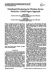
CONFIDENTIAL. Limited circulation. For review only. When a detection from the specified algorithm occurs, the indicated rule is triggered to give the end-user’s preference for how the region where the detection occurred should be scanned by the radars. The “revisit” column tells the sample rate and is related to the expected dynamics of the weather phenomena (its horizontal movement over the ground, its growth rate in size, and its evolution of internal structure). The “sector”, “elevations”, and “#radars” columns gives preferences for how to scan the region. “Sector” indicates that the entire region that contains the detected weather phenomena should be scanned. “Elevations” indicates the number of elevations that should be scanned so that the user can study the vertical structure of the phenomena. “#radars” indicates how many radars to use to get the multiple views needed for improved resolution and velocity field extraction. Given that a radar can only scan 1/6th of its surrounding volume during the 40 second DCAS targeted sector scanning period, there is a clear conflict between the requirement to obtain complete coverage of a weather feature and the requirement to get a full 14 elevation scan of the feature. The need to use multiple radars for velocity field extraction also imposes serious constraints on resource allocation options. Fig. 1 shows a schematic of the IP1 Meteorological Command & Control (MC&C). As the main control loop, the MC&C is responsible for mapping the history of past sector scans and the current set of detected weather features into the set of radar sector scans that optimally trades-off resource conflicts to maximize the degree to which the enduser rules in Table I are satisfied [16, 23, 28].
1. Radars Scan atmosphere and send data to central repository
2. Weather Detection Algorithms run on the data
query
MC&C: Meteorological command and control
streaming storage
detection algorithms
3. Detections and other data are “posted” in Feature Repository, a 3-d Grid of test bed region
Feature Repository A B C D
E F G
H I J K
user rules, weights optimization
1 2 G3 G3 G3 G3 G3 G3 G3 G3 G3 G3 G3 G3 G3 G3 R1 R1 R1 F1 R1 H1, F1 R1 H1
3 4 G3 G3 G3 G3 G3 G3 G3 G3 G3 G3 G3 G3 G3 G3 R2 R2 F2,R1 F2,H2 H1,F1 T2,R1 T2,H1 T2,R1
5 G3 G3 G3 G3 G3 G3 G3 R1 R1 R1 R1
6 G3 G3 G3 G3 G3 G3 G3 G3 G3 G3 G3
7 G3 G3 G3 G3 G3 G3 G3 C2 C2 C2 G3
meteorological task generation
8 G3 G3 G3 G3 G3 G3 G3 G3 G3 G3 G3
9 G3 G3 G3 G3 G3 G3 G3 G3 G3 G3 G3
End users: NWS, emergency response, researchers
resource allocation
5. Radar scanning commands for next heartbeat are selected by optimizing: • Aggregate User Utility (weights and rules) • Scan Quality Utility
so that in general the brighter the color the greater the precipitation. The 1st moment, the Doppler velocity, being much harder for the layperson to interpret, is rarely shown on television. The 3rd moment gives the wind shear. Polarimetric variables can tell the shape of the water droplets and can thus be used to estimate rainfall amounts. See [9] for details about weather radar. The moment and polarimetric data goes to a feature board from where it is shipped out over the Internet of be visualized by the end-users. The feature board contents are also shipped to the detection algorithms that steer the radars. After clustering the raw detections based on type and location, each cluster then triggers one or more of the rules in Table I. The scanning requirements specified by the rules (revisit rate and scan strategy preference) is then used by an optimization procedure which searches the space of radar configuration (one sector for each radar) that will maximize the rule satisfaction. The output of the optimization is the sector that each radar will scan during the 40 second DCAS period on the next 1 minute system heartbeat. Fig. 2 shows some tasks and the resulting optimal scan.
Fig. 2. IP1 operators interface showing weather features (yellow polygons), scanning tasks (brown polygons), and sectors (shown in green, with the rings along the sector edge denoting the number of elevation angles in the scan).
4. Tasks are generated based on detections, GIS and User Rules
Fig. 1. Schematic showing the flow of data and control within IP1.
Starting at the radars let us go clockwise around the loop. At each radar the radar echoes are received, sampled into digital form, and processed by signal processing algorithms to extract the meteorological moments and polarimetric variables. For Doppler weather radar, the 0th moment, the reflectivity, is probably familiar to most readers as it’s the radar image most commonly shown by television weather people (cf. http://www.wunderground.com/radar/map.asp). Reflectivity is a measure of the density of the water droplets,
IV. MC&C EQUATION As described, the IP1 resource allocation problem is to determine for each radar the sector to scan during the 40 second DCAS period of each system heartbeat. For each radar this is a search for the orientation of the sector – a real number in the range [0,360) degrees – and the sector width – a real number in the range [60,360). To determine the optimal configuration of sectors, the IP1 MC&C uses a multi-attribute utilities based approach. As a systematic method for decision problems involving multiple users with multiple competing preferences and objectives, multi-
Preprint submitted to 2008 American Control Conference. Received September 24, 2007.
CONFIDENTIAL. Limited circulation. For review only. attribute utility theory (MAUT) [15] is becoming increasingly popular for allocating resources in sensor networks [1, 7, 17]. The MC&C assigns two utilities to each detected weather feature – a utility score U telling how important the task is to the end-users, and a scan utility function Q that relates how well a particular set of sectors meets the scanning requirements of the rule(s) from Table I that are associated with the detected feature. A function which we call the MC&C equation combines these two factors of how important with how well to determine the set of sectors that can be expected to satisfy the maximum number of the highest value tasks. Specifically, the multi-attribute MC&C equation which the optimization component of the MC&C is seeking to maximize has the form,
(
)
(1) J (C ) = ∑ U (t )I Q (t,C ) ≥ 0.6Q (t ) max t where the optimization is over C, the radar configuration defining a sector for each of the four radars, i.e., C = {sr:r=1,…,4}, where sr is the sector to be scanned by radar r. The summation in (1) is over all tasks t; volumes where potentially interesting weather activity has been detected by the weather detection algorithms. U is the utility function telling how important the task is to the end-users. Q is the utility function telling the expected scan quality if the task t is scanned under sector configuration C. Qmax(t) is the maximum scan quality the network could achieve if task t were the only task in the network. I( ) is the indicator function (= 1 if its argument is true; 0 otherwise). As we will next explain, optimizing the MC&C equation in (1) can be interpreted as the preferential allocation of the sensor resources to satisfy those scanning tasks that the endusers have collectively agreed are the most important to satisfy. A. Task Utility The task utility U(t) reflects the collective end-user preference for scanning task t at the next heartbeat. It is calculated in two steps. First each of the different user groups g (NWS, EMs, Researchers) assign a utility value to the task according to, 0.0 if this user is not interested in this task 0.3 if k − k < r , this task was recently scanned (2) s t U t,k − k = 0.8 if k − k = r , this task is due for scanning s g t s 1.0 if k − k > r , this task is overdue for scanning s t
(
)
( ) ( ) ( )
where k is the index of the current heartbeat, ks is the index of the heartbeat when the task was last scanned, and rt is the interscan period as defined in the “revisit” column in the rule table in Table I. To get ks we have a simple tracker that associates tasks detected on different heartbeats and tracks their movement through the radar network. Recall from the rules in Table I that only tornados, which have very fast
dynamics, need to be scanned at the once per minute system heartbeat. Thus, by raising and lowering the utility of a task, the system will begin to interleave conflicting tasks to alternate heartbeats allowing it to maintain the desired sample update rates even with very large numbers of tasks in the network. This is a simple idea that allows us to skirt what is otherwise a very hard multi-stage optimization problem (see [18] for a stochastic dynamic programming approach to the CASA DCAS problem). Given Ug for each user group g, the aggregated utility for scanning the task during the next heartbeat is obtained from (2) according to, U (t ) = wgU g (t , k − k s )
(3)
where wg is the “priority” of user group g. Taking values between 0 and 1, wg determines the relative effort the system will make to satisfy user g’s scanning needs. While priority weights are a common way to combine user needs in multiusers systems, getting users to agree on what their priority value should be can be very difficult. We view wg as a mechanism for setting user priorities. An on-going research project to relate the value of each user group to the socioeconomic impact of the role that they play will ultimately develop a procedure for assigning the wg values [23]. Also note that in our small four node system, Ug depends only on time since last scanned. In a large network it would also depend on other attributes such as location since, for example, an emergency manager is generally only concerned with their local area of responsibility and would not want to be overwhelmed by the weather far outside this area. B. Scan Quality The scan quality function Q estimates the degree to which a scan done under sector configuration C will satisfy the scanning requirements spelled out in columns 3-5 of the user rules in Table I. The value of Q is estimated in two steps. First each radar determines its individual scan quality q. Then the individual scan qualities are combined to get the combined network scan quality Q. Individual scan quality – The individual scan quality q(t,r,sr) gives the degree to which the sector sr scanned by radar r satisfies coverage and elevations constraints of task t’s rule. Specifically, let us define: w(sr) = the azimuthal width (in degrees) of radar r’s sector; a(r,t) = the minimal azimuthal angle that would allow radar r to just cover task t’s area; h(r,t) = the distance from the radar to the geometric center of the task; and hmax(r) = the range of radar r. Then the individual scan quality is given by, q(t,r,sr) = Fc(c(t,r,sr))[αFe(e(w(sr))/er(t) + (1- α)Fd(d(r,t))] (4) where, in terms of the above definitions, c(t,r,sr) = w(sr) / a(r,t) is the coverage of task t by radar r with sector sr; e(w(sr)) = 840 / w(sr) is the number of elevations a radar
Preprint submitted to 2008 American Control Conference. Received September 24, 2007.
CONFIDENTIAL. Limited circulation. For review only. scanning a sector w(sr) degrees in azimuth at an angular rotation rate of 21 degrees / second can do in the 40 second DCAS time period; er(t) = the number of elevations required by task t’s rule; d(r,t) = h(r,t) / hmax(r) is the normalized distance from radar r to the geometric center of task t; α ∈ [0,1] is a tunable parameter (set to 0.9 in the current implementation); and Fc, Fe, and Fd are the step functions defined in Fig. 3a-c respectively. The rationale for Equation (4) is as follows. The first term Fc(c(t,r,sr)) accounts for how well the task is covered in azimuth. Noting that this term multiplies the other terms in equation (4) we see that if the task is not entirely covered in azimuth, i.e., of the field of view of the radar does not cover the entire area of the task in azimuth, the scan quality is zero. The second term Fw(w(sr)) penalizes scans that don’t get all of the elevations requested by the task’s rule. The third term Fd(d(r,t)) is included to decide which radar(s) to use when the task is in the coverage area of more than one radar. According to Fd(d(r,t)), radars closer to a task tend to result in better scan quality due to considerations such as intervening attenuation and resolution degradation caused by increased angular beam spreading with distance (see also [2, 25]).
Fig. 3. Definitions of the step functions used in equations (2) and (4).
Combined Scan Quality – Given the q values obtainable by each radar individually, the combined scan quality Q gives the degree to which the radars acting together in a coordinated fashion satisfy the scanning requirements of the task. Looking back at the “#radars” column in Table I we see that there are tasks that only require one radar (generally any task just looking for areas of reflectivity) and tasks that require views from multiple radars (generally tasks requiring velocity field extraction). For tasks requiring a single radar, we simply take the maximum of the individual scan qualities, Q(t,C | #radars = 1) = max [q (t , r , s r )] r =1, 2,3, 4
(5)
where as before r is the index of the radar and sr is the sector scanned by radar r under scan configuration C.
For tasks that require multiple radars we combine the individual scan qualities according to,
(
∑ q t , r, sr r =1, 2,3, 4
Q(t,C | #radars = 2+) = F pp
)
(6)
where the function Fpp( ) is as defined in Fig. 3d. Noting that q(t,r,sr) ∈ [0, 1] for each radar r, the interpretation of equation (6) is to give increasing utility for each additional radar that scans the task – the more radars scanning the task, the better the ability to resolve velocity vectors. As we can now see, optimizing the MC&C equation in (1) can be interpreted as the preferential allocation of the sensor resources to satisfy those scanning tasks that the end-users have collectively agreed are the most important to satisfy. V. PERFORMANCE ANALYSIS Preliminary experiments were conducted to assess how well the IP1 MC&C design is able to satisfy end-user needs by evaluating how well the system is able to satisfy the rules that define those needs. Data for the experiments was obtained from actual scans of a severe storm that passed through the IP1 testbed between 2:30AM and 5:00AM on 16 August 2006. See [4] for a system level discussion of network operations during this August storm event. This storm was of sufficient severity for the NWS to issue one thunderstorm warning and several severe wind reports. A. DCAS Sector Scanning Algorithm Performance Over the 2.5 hours of the experiment there were a total of 2943 tasks submitted to the optimization for scanning, for an average of 10.3 tasks per heartbeat. Of these a total of 1221 tasks, or an average of 4.3 per heartbeat, could not be satisfied during a typical heartbeat due to resource conflicts. As expected, the tasks that the system had difficulty satisfying were those requiring 14 elevation volume scans of spatially isolated sectors. Specifically, of the average 8.9 such tasks generated per heartbeat, an average of 4.3 (48%) were not satisfied. On the other hand, recall that if a task due to be scanned at a particular heartbeat is not satisfied we increase its utility and continue to resubmit it for satisfaction until such time as it is either satisfied or moves out of the network. A consequence of this strategy, however, is that unsatisfied tasks could begin to accumulate and overwhelm the system. The plot in Fig. 4 shows that this is not happening, meaning that although the system is not able to satisfy every task immediately when it is due to be scanned, the system does eventually satisfy all tasks submitted to the system. In fact, because we record the total delay between the time a task is submitted and the time it is scanned we can estimate the sample rate performance of the system. For tasks associated the with 14 elevation sector scans, the average sample rate was 55.26 seconds between scans (thus more than satisfying the once per 2-minute required sample rate. For tasks associated with numerical weather prediction, the average
Preprint submitted to 2008 American Control Conference. Received September 24, 2007.
CONFIDENTIAL. Limited circulation. For review only. sample rate was 3.55 minutes between scans, thus beating the once per 10 minute sample rate requirement. The reason the rules are oversampled is that all rules are always active, i.e., even when not due for scanning every task is given a non-zero utility score of 0.3. Hence, when there are no high utility tasks due for scanning at a given heartbeat, the system will not sit idle, but will generate scans of these low utility tasks. B. Sit-and-Spin Algorithm Performance To show the advantages of the DCAS approach of targeted sector scanning we compared its performance to the socalled sit-and-spin scanning algorithm. Sit-and-spin scanning can be viewed as the no control case – the sit-andspin strategy simply repeating 360° sweeps of the lowest 2 elevations with every heartbeat. The results were obtained by replaying the tasks generated during the 16 August 2006 storm event through the MC&C while we operated it in sitand-spin mode. Except for the fact that we did not use the output of the optimization to generate the beam steering commands, sit-and-spin went through all the same steps of task generation, task utility assignment, and resubmission of unsatisfied tasks as used by our sector scanning algorithm. Over the 2.5 hours of the storm, 8287 tasks – or an average of 28.1 tasks per heartbeat – were submitted to the sit-and-spin algorithm for satisfaction. Of these, only 7% were satisfied at any given heartbeat. As expected, because sit-and-spin can only get 2 elevations in 40 seconds very low value was obtained for any task requiring a full 14 tilt scan. The resubmission of these unsatisfied tasks from one heartbeat to the next explains why sit-and-spin had so many more tasks than the sector scanning algorithm.
system evaluation for a fall storm season experiment, which is on-going as this paper is being written. The MC&C design described in this paper deals primarily with the problem of deciding where to point the radars in a DCAS network. Exciting ongoing work within the CASA MC&C group includes distributing the optimization which is currently centralized; incorporation of other sources of GIS information such as NEXRAD detections; adding nowcasting for short term predictive capabilities; and the ability to adapt dwell time (via varying azimuthal scan rate) in response to the observed weather. Also being explored is the design of revolutionary new network-centric scanning strategies that exploit capabilities that can only be realized by coordinated multi-Doppler scanning such as network based attenuation correction and velocity estimation (cf. [13]); and MC&C designs for future CASA IPs, which will use advanced phased array radars under development by CASA with their “zero intertia” instantaneous beam pointing and their ability to obtain high quality even at high scan speeds. With IP1 operational, our end-users are now evaluating the data quality being obtained under the end-user scanning rules. As they become familiar with the new paradigm of targeted sector scanning this will surely suggest new scanning strategies and new rules to execute them. Under a new supplement to the CASA grant, we have also started research to incorporate the socioeconomic value of CASA data into our end user policy and resource allocation algorithms. This is involving the development of an integrated decision model of the end-to-end IP1 system to quantitatively link “upstream” technical capabilities, such as targeted sector scans of the bottom 1km of the troposphere, to their impacts on “downstream” responses such as NWS warning decisions, EM risk communication, public response, and the resulting incremental socioeconomic impacts. This end-to-end model will allow us to identify those DCAS capabilities and end-users that provide greatest socioeconomic value. REFERENCES [1] [2] [3]
Fig. 4. Number of tasks in the system at each heartbeat.
VI. CONCLUSIONS This paper described a multi-attribute utility-based approach for resource allocation in a distributed collaborative adaptive sensing (DCAS) network of weather radars. This network which has been deployed and is being tested by the CASAERC showed good closed-loop performance in a severe weather situation. The final paper will have a more complete
[4]
[5]
[6]
F. Bain, D. Kempe, and R. Govindan, “Utility-Based Sensor Selection,” IPSN’06, 2006. K.A. Brewster, E.C. Fay, and F. Junyent, “How will X-band Attenuation Affect Tornado Detection in the CASA IP1 Radar Network,” AMS 32nd Conf. on Radar Meteorology, October 2005. K.L. Brewster, L. White, B. Johnson, and J. Brotzge, “Selecting the Sites for CASA NetRad, a Collaborative Radar Network,” 9th Symposium on Integrated Observing and Assimilation Systems for the Atmosphere, Oceans, and Land Surface (IOAS-AOLS), San Diego, CA 2005. J. Brotzge, K. Brewster, V. Chandrasekar, B. Philips, S. Hill, K. Hondl, B. Johnson, E. Lyons, D. McLaughlin, and D. Westbrook, “CASA IP1: Network Operations and Initial Data,” 23rd Conference on IIPS, 2007. J. Brotzge, D. Westbrook, and M. Zink, “The Meteorology Command and Control Structure of a Dynamic, Collaborative, Automated Radar Network,” 21st Int. Conf. on Interactive Information Processing Systems for Meteorology, Oceanography, and Hydrology, 2005. D.D. Corkill, “Blackboard Systems,” AI Expert, Vol. 6, No. 9, pp. 4047, September 1991.
Preprint submitted to 2008 American Control Conference. Received September 24, 2007.
CONFIDENTIAL. Limited circulation. For review only. [7]
[8] [9] [10] [11] [12]
[13] [14] [15] [16]
[17] [18] [19] [20]
[21] [22] [23]
[24] [25] [26] [27] [28]
F. Drews, L. Welsh, D. Juedes, D. Fleeman, A. Bruening, K. Ecker, and M. Hoefer, “Utility-Function based Resource Allocation for Adaptable Applications in Dynamic, Distributed Real-Time Systems,” Proc. of the 18th Int. Symposium on Parallel and Distributed Processing, 2004. B. Donovan and D. McLaughlin, “Improved Radar Sensitivity through Limited Sector Scanning: The DCAS Approach,” Proc. of AMS Radar Meteorology, 2005. R.J. Doviak and D.S. Zirnic, Doppler Radar and Weather Observations, Academic Press, 1993. J. Durkin, Expert Systems: Design and Development, Prentice Hall, 1994. Y. He and E.K.P. Chong, “Sensor Scheduling for Target Tracking: A Monte Carlo Sampling Approach,” Digital Signal Processing, 2006. K. Hondl, V. Lakshmanan, T.M. Smith, and G.J. Stumpf, “Warning Decision Support System – Integrated Information (WDSS-II) Progress and Plans, 23rd (IIPS) for Meteorology, Oceanography, and Hydrology, January, 2007. E. Insanic and P. Siqueira, “Vector Velocity and Vector Velocity Error Estimates in a Networked Radar System,” in preparation, 2007. V. Jaganathan, R. Dodhiawala, and L. Baum, Blackboard Architectures and Applications, Academic Press, 1989. R. Keeney and H. Raffia, Decisions with Multiple Objectives, Cambridge University Press, Cambridge, 1976. J. Kurose, E. Lyons, D McLaughlin, D. Pepyne, B. Philips, D. Westbrook, and M. Zink. “An End-User-Responsive Sensor Network Architecture for Hazardous Weather Detection, Prediction and Response”, AINTEC, 2006. G. Mainland, D.C. Parkes, and M. Welsh, “Decentralized, Adaptive Resource Allocation for Sensor Networks,” online. V. Manfredi, “A Comparison of Myopic and non-Myopic Scanning Strategies in A DCAS Meteorological Sensing Network,” in preparation, CS Dept., UMass, Amherst. V. Manfredi,, S. Mahadevan, and J. Kurose, “Switching Kalman Filters for Prediction and Tracking in an Adaptive Meteorological Sensing Network,” Proc. of IEEE SECON, 2005. D.J. McLaughlin, V. Chandrasekar, K. Droegemeier, S. Frasier, J. Kurose, F. Junyent, B. Philips, S. Cruz-Pol, and J. Colom, “Distributed Collaborative Adaptive Sensing (DCAS) for Improved Detection, Understanding, and Prediction of Atmospheric Hazards,” preprints of the AMS 9th Symposium on Integrated Observation Assimilation Systems – Atmosphere, Oceans, Land Surface, 2005. D.J. McLaughlin, E.A. Knapp, Y. Wang, and V. Chandrasekar, “Distributed Weather Radar Using X-Band Active Arrays,” conference reference, 2007. National Research Council, Weather Radar Technology: Beyond NEXRAD, National Academy Press, 2002. B. Philips, D. Pepyne, D. Westbrook, E. Bass, J. Brotzge, W. Diaz, K. Kloesel, J. Kurose, D. McLaughlin, H. Rodriguez, and M. Zink, “Integrating End-User Needs into System Design and Operation: The Center for Collaborative Adaptive Sensing of the Atmosphere (CASA),” AMS, 2007. D.E.R. Pritchard, Dynamic Route Planning-Replanning and Retasking of Unmanned Aerial Reconnaissance Vehicles, AFIT Thesis, 2000. J. Proud, K.K. Droegemeier, V.T. Wood, R.A. Brown, and L. White, “Optimal Sampling Strategies for Hazardous Weather Detection using Networks of Dynamically Adaptive Doppler Radars,” 2005. M.K. Schneider and C. Chong, “A Rollout Algorithm to Coordinate Multiple Sensor Resources to Track and Discriminate Targets,” SPIE, 2006. B.A. Stiles, Application of Sequential Auction Techniques to Nonlinear Targeting Assignment for Space-Delivered Entry Vehicles, Masters Thesis, Rice University, Huston TX, May 2004. M. Zink, D. Westbrook, S. Abdallah, B. Horling, V. Lakamraju, E. Lyons, V. Manfredi, J. Kurose, and K. Hondl, “Meteorological Command and Control: An End-to-end Architecture for a Hazardous Weather Detection Sensor Network,” Workshop on End-to-End, Sense-and-Respond Systems, Applications, and Services, Seattle, WA, 2005.
Preprint submitted to 2008 American Control Conference. Received September 24, 2007.