5 Experiencing the Past: Computer Graphics in Archaeology Filippo Stanco University of Catania Email:
[email protected] Davide Tanasi Arcadia University - Mediterranean Center for Arts and Sciences Email:
[email protected]
CONTENTS 5.1 The Past and the Future: Archaeology and Computer Science . . . . . 5.2 From the Field to the Screen: 3D computer graphics and the Archaeological Heritage . . . . . . . . . . . . . . . . . . . . . . . . . . . . . . . . . . . . . . . . . . . . . . . . . . . . . . . 5.2.1 3D computer graphics and the Archaeological Fieldwork . . 5.2.2 Monitoring the Heritage . . . . . . . . . . . . . . . . . . . . . . . . . . . . . . . . . . 5.2.3 The Virtual Museum . . . . . . . . . . . . . . . . . . . . . . . . . . . . . . . . . . . . . . 5.2.4 3D Modeling as Cognitive Tool . . . . . . . . . . . . . . . . . . . . . . . . . . . 5.3 The Archeomatica Project . . . . . . . . . . . . . . . . . . . . . . . . . . . . . . . . . . . . . . . . 5.4 Archaeological 3D modeling . . . . . . . . . . . . . . . . . . . . . . . . . . . . . . . . . . . . . 5.5 Haghia Triada, Crete . . . . . . . . . . . . . . . . . . . . . . . . . . . . . . . . . . . . . . . . . . . . . 5.5.1 Propylon . . . . . . . . . . . . . . . . . . . . . . . . . . . . . . . . . . . . . . . . . . . . . . . . . 5.5.2 House of the Razed Rooms . . . . . . . . . . . . . . . . . . . . . . . . . . . . . . . 5.5.3 VAP House . . . . . . . . . . . . . . . . . . . . . . . . . . . . . . . . . . . . . . . . . . . . . . . 5.6 Digital Restoration . . . . . . . . . . . . . . . . . . . . . . . . . . . . . . . . . . . . . . . . . . . . . . . 5.6.1 Minoan Model . . . . . . . . . . . . . . . . . . . . . . . . . . . . . . . . . . . . . . . . . . . . 5.7 Dealing with Image Data in Archaeology: New Perspectives . . . . . . Acknowledgments . . . . . . . . . . . . . . . . . . . . . . . . . . . . . . . . . . . . . . . . . . . . . . . . Bibliography . . . . . . . . . . . . . . . . . . . . . . . . . . . . . . . . . . . . . . . . . . . . . . . . . . . . .
52 53 53 54 55 56 58 58 60 62 64 65 70 71 72 75 75
51
52
5.1
Radamante al computer. Archeologia e informatica...
The Past and the Future: Archaeology and Computer Science
In the last fifty years, the growing use of computer applications has become a main feature of the archaeological research [1]. Since the ’90s, when Computer Science was oriented to the creation of work tools and solutions for the archive and management of quantitative data, to the development of virtual models and to the dissemination of knowledge, it quickly changed into a true theoretical approach to the problems of archaeology. It is now, indeed, able to influence the interpretation procedures and to revolutionize the language and contents of the study of the past [2]. This new evidence introduced in several branches of the theoretical debate new scientific themes. There are different views about the integration of computers and archaeology. Digital archeology in the Anglo-Saxon cultural world [3] is considered as a computer approach to the modern cognitive archaeology. Archaeological computing [4], on the other hand, is a methodology for the elaboration of archaeological data via computer. Archaeological computer science [5] is devoted to the representation with computer applets of the cognitive procedures behind the interpretation of the archaeological data, and the more popular Virtual Archaeology (VA) [6], is the analysis of the procedures of management and representation of the archaeological evidence through computer graphic 3D techniques. From its first definition, by Reilly in 1991 [7], VA was intended as the use of digital reconstruction in archaeology. Recently to its research the development of new communicative approaches to archaeological contents through the use of interactive strategies has been added. The birth of the VA is not simply caused by the proliferation of 3D modeling techniques in many fields of the knowledge, but as a necessity to experience new systems to archive an overgrowing amount of data and to create the best medium to communicate those data with a visual language. From this point of view, the application of 3D reconstructions, obtained with different available techniques, became the core area of study of the VA in regard to the potential of cognitive interaction offered by a 3D model. In this way, virtuality
Experiencing the Past: Computer Graphics in Archaeology
53
turns into a a communication method even more effective if applied to particular fields, archaeological areas well preserved but not accessible [8], sites not preserved but known by traditional documentations [9], sites destroyed but depicted in iconographical repertoires [10], contextualization in progressive dimensional scale (object, context, site, landscape), and functional simulations repeating in virtual ambient the processes of the experimental archaeology.
5.2
From the Field to the Screen: 3D computer graphics and the Archaeological Heritage
The cognitive experiences of 3D computer graphics can essentially be divided into passive and active forms of interaction. The first case refers mainly to applications related to research and study, where the primary need is of documentary type, as the archaeological excavation or the monitoring of the degradation. In the second case, the interaction with the virtual recreated reality is further exploited in the enhancement of the archaeological heritage through the creation of a virtual museum, reachable on digital media or on the web, intended both as a virtual version of a proper museum and as a closer study of an archaeological site. Different is the case of the 3D reconstructions, developed within interdisciplinary research projects, made for the purpose of interpretation as a cognitive accessory available to the archaeologists.
5.2.1
3D computer graphics and the Archaeological Fieldwork
The other major field of application of 3D computer graphics in the world of archeology is the documentation of the excavation data in real time. Since archeology is the science of destruction par excellence, the need to document in a comprehensive and detailed way each item that is removed during excavation, imposed gradually the methods of graphic and photographic
54
Radamante al computer. Archeologia e informatica...
documentation in support of traditional 3D modeling [11]. This technique can be used both for recording singular evidence but also for the objects set inside a GIS system in which 3D data are fully integrated. From this point of view the combination of GIS systems in archaeology and the development of 3D laserscanning and image-based 3D modeling techniques determined the birth of experimental systems of 3D GIS. This system is able to visualize inside the geographic information system 3D data, such as point clouds from laser scanners, and it has already produced excellent results as demonstrated in the case of Miranduolo excavation (Siena) Italy [12] or in the investigations in the Jabal Hamrat Fidan region of the Faynan District in Southern Jordan [13], just to name a few recent examples. The point of the application of these techniques on the excavation activity is the possibility to perform analysis on multidimensional scale. At landscape scales, digital 3D modeling and data analysis allow archaeologists to integrate, without breaks, different archaeological features and physical context in order to better document the area. At monument/site scale, 3D techniques can give accurate measurements and objective documentation as well as a new aspect from a different point of view. At artifact scale, 3D modeling allows the reproduction of accurate digital/physical replicas of every artifact that can be studied, measured and displayed, as well as data for general public use, virtual restoration, and conservation.
5.2.2
Monitoring the Heritage
3D modeling could also be extremely useful for the identification, monitoring, conservation, restoration, and promotion of archaeological goods. The archaeological heritage is always under constant threat and danger. Architectural structures and cultural and natural sites are exposed to pollution, tourists, and wars, as well as environmental disasters such as earthquakes, floods, or climatic changes. Hidden aspects of our cultural heritage are also affected by agriculture, changes in agricultural regimes due to economic progress, mining, gravel extraction, construction of infrastructure, and the expansion of industrial areas. In this context, 3D computer graphics can support archaeology and the politics of cultural heritage by offering scholars
Experiencing the Past: Computer Graphics in Archaeology
55
a “sixth sense” for understanding the traces of the past, as it allow us to experience it [14]. 3D documentation of still existing archaeological remains or building elements is an important part of collecting the necessary sources for a virtual archaeology project. New developments allow this documentation phase, including the obtaining of correct measures and ground plans from photography using freely available tools. This is important when restoring archaeological remains, when older phases are reconstructed in a virtual way. The original state, the restored state, and eventual in between states can be recorded easily through this photo modeling technique [15]. Furthermore, the recent application of 3D computer graphics has proved crucial in planning strategies of restoration and conservation issues of monuments that are part of world cultural heritage, on which there is still an open debate, as in the case of the restoration of the Parthenon on the Acropolis of Athens [16].
5.2.3
The Virtual Museum
The rapid development of 3D visualization techniques, and the subsequent derivation in the promotion policies for the archaeological heritage as well as the creation of 3D models of monuments and artifacts of past civilizations has become the basis for the birth of the concept of virtual museum as a means of transmission of knowledge based on the use of multimedia [17, 18]. More recently, the seductive ability of visual communication, simplified and made more attractive by the opportunity to interact intuitively with multimedia content, has led to a huge proliferation of virtual museums on the web. The phenomenon in some cases has grown, losing sight of what are the ideological assumptions of the virtual museum itself. The virtual museum should not be considered as a transposition of a real museum in electronic form or on the web, nor can it be intended as a supplementary tool to complete the real museum, like a sort of exhibition space or additional digital catalog. Its nature is closely linked to its ultimate goal, namely to communicate knowledge to the wider audience possible, without stopping at generalizations between “scholars” and “public.” This aim is achieved with the use of communication strategies based on visual narratives, interactive
56
Radamante al computer. Archeologia e informatica...
multimedia narratives that tell the story of each artifact, contextualizing it geographically, historically, and culturally and embedding it into a network of information that goes beyond the artifact itself and what the real museum contains. In this perspective, the virtual museum has its best expression in the version of the “museum of territory” which virtually took out of the museum’s closed walls the original cultural background of an entire territory. The virtual museum can also be considered as “a communicative projection of the real museum” which performs a dual function: educational, thanks to technology capable of overcoming language, physical, and cultural barriers, and promotional, as tool of cultural exportation [19]. Furthermore, the use of virtual reality and augmented reality technologies may make even more immersive and involving the experience of decoding the information. Just to cite an example of excellence in the most recent virtual museum project, it can be mentioned the Iraq Virtual Museum [8,9,20–22], completely accessible from the web, where the most advanced digital visualization techniques have been applied. It was promoted between 2006 and 2007, by the Italian National Research Council and the Italian Ministry of Foreign Affairs, as a concrete action for the cultural development of the Iraqi people through a targeted intervention for recovery of the Baghdad Museum intended as a shared treasure. Closed to the public in 1991, during the First Gulf War, and subjected to severe devastation and looting in 2003, during the turmoil of the Second Gulf War, the Museum of Baghdad and its archaeological treasures, which covers 8,000 years of Mesopotamian history, were returned to the community only in February of 2009, thanks to the efforts of many countries.
5.2.4
3D Modeling as Cognitive Tool
Computer graphics can be applied to the reconstruction and visualization of several features of an archaeological site with the creation of a multidimensional model including every feature derived from the excavations. This process is fundamental for scholars of virtual archaeology, the goal of which is the complete reconstruction of an ancient landscape. Computer science has a primary role in this branch of cognitive archaeology, and 3D modeling
Experiencing the Past: Computer Graphics in Archaeology
57
is not considered to be an optional implement for the addition of aesthetic elements in reconstructions, but an indispensable tool for interpretation. The available technologies and methodologies for the digital recording of archaeological sites and objects are promising, and the scientific community is trying to adapt these approaches for detailed 3D documentations to go beyond the simple graphic and photographic data. The process of interpretation of archaeological evidence, often fragmentary and subject to many variables of alteration, finds in 3D computer graphics a valuable experimental environment in which to test the reliability of the assumptions. Often what makes sense during a study about the nature and function of artifacts poorly preserved and stored in store boxes, can be completely changed by a simple passive observation of a 3D reconstruction, if not completely disavowed by interactive or immersive virtual models in which the man-space-artifact-building relation is recreated. From this point of view, the 3D computer graphics become on the same level of the archeology itself, as a digital version of the experimental archaeology [23–25], characterized by the study of the “practice supporting the theory” [26]. It aims to the replication of experiments, the testing of methodological assumptions by applying them to known contexts, the experiments involving site formation processes. In the same way a similar research can be virtually conducted interacting with a 3D model replicating the reality. It is not a coincidence that in recent years several interdisciplinary projects of reconstructing the past have been completed thanks to the combination of the experiences both of experimental archaeology and 3D computer graphics [27]. In this sense of cognitive tool, the use of 3D models in archaeological research can be intended as a sort of benchmark of what the perceptual senses and the mind perceived in the first instance. A sort of “seeing causes believing” opposed to a simple and sometimes misleading “seeing is believing” which is often altered by the cultural superstructure of the archaeologists [28]. In this case digital technology is not only used to provide tools of discovery and communication but mostly interactive feedback [29]. Just this aspect of computer graphics in archaeology is that privileged by the multidisciplinary research projects of digital archeology, which aim to bridge the linguistic and cultural gap that still divides the researchers of archaeology and com-
58
Radamante al computer. Archeologia e informatica...
puter science and to contribute to the common reconstruction of the past through its virtual experiencing.
5.3
The Archeomatica Project
A digital archaeology research project, directed by the authors, the Archeomatica Project [30] was begun in late 2007 by a group of prehistoric archaeologists and researchers in Image Processing and computer graphics from the Image Processing Lab [31], both of them of the University of Catania. It aims to develop new implements for archaeological research in prehistory and protohistory within the field of 2D digital imaging and 3D graphics, mainly, to produce automatic systems of recognition and classification of graphic data, such as pottery figurative decoration, through the use of Computer Vision and Pattern Recognition techniques and to develop virtual models of prehistoric sites and items with a high degree of accuracy following the data obtained during excavation and study, through application of laser scanner and 3D modeling techniques. A cognitive process based on a peer-to-peer exchange of knowledge between experts of computer science and prehistory working side by side. The cooperative experience of the Archeomatica Project, which represents (through its scientific production) the most recent trends in digital archaeology and the modern politics of conservation of archaeological heritage, has also aimed to define a common multidisciplinary language to improve the quality of the message of this new discipline to the outside world. In these first years of research activity the Archeomatica Project has produced significant results in archaeological 3D modeling and for 3D digital restoration, in order to improve the cognitive capacities of the archaeologists.
Experiencing the Past: Computer Graphics in Archaeology
5.4
59
Archaeological 3D modeling
Archaeological 3D modeling is basically the recreation of landscapes, architecture, and objects by digital means based upon the current state of the salvaged monuments integrated with the data coming from historical and archaeological researches using software for developing 3D models [32], without the application of reverse engineering methodology. It is probably the most popular computer-based technique applied to cultural heritage as it represents the core of the “serious games” used in many multimedia projects [33]. The archaeological 3D modeling is not just a simple cognitive tool to reproduce virtually aspects of the past, like objects of everyday life [34], to improve the knowledge and the comprehension. It is also, above all, a methodology of recording all the archaeological data in a much more complete way than the traditional photography and drawing and it is also an instrument of interpretation for the researchers who are involved in the theoretical reconstruction of the past itself. From this point of view, it is a kind of virtual benchmark of the archaeologists’ theories where the hypothesis is tested and corrected in order to produce a truthful image of something buried by time. A kind of “solid modeling to illustrate the monument” becoming “solid modeling to analyze the monument” [35]. For this reason, the privileged application field for this technique is the prehistoric archaeological research, where, the scarcity of iconographical sources and the poor state of conservation of the findings, makes extremely complex both the process of decoding the information and of transmitting the knowledge to the public. The researchers of the Archeomatica Project have chosen Blender [36] as a work tool, an open source cross-platform software for modeling, rendering, animation, post-production, creation, and playback of interactive 3D contents, extremely versatile, functional, and constantly open to implementations based on the research of its application in various fields. Where it was necessary for particular issues, image-based 3D modeling techniques, which consist in the elaboration of a 3D model from a set of high quality digital photos, have also been used [37, 38].
60
Radamante al computer. Archeologia e informatica...
The study cases chosen for testing the archaeological 3D modeling are the houses of Haghia Triada (Crete, Greece), a pre-protohistoric archaeological complexes, which have been the subject of research of the archaeologists from the University of Catania for a long time, and which represent the full cultural evolution of Crete between the second and first millennium BC. The decision was also supported by the small number of applications of 3D computer graphics on the Cretan archeology [39–41], a fact that greatly limits the interpretation study of evidences.
5.5
Haghia Triada, Crete
The site of Haghia Triada [42], in the Mesara plain in Crete, is one of the main sites of the Minoan civilization, constantly under study by the Centre for Cretan Archaeology of the University of Catania, under the permission of the Italian Archaeological School at Athens. The settlement of Haghia Triada has developed seamlessly over nearly two millennia, from the fourth to the second millennium BC, between the Early Bronze Age and the Early Iron Age. The flourishing of the site coincides with the Neopalatial period (from the seventeenth to the first half of the fifteenth century BC) and the Palatial Final period (from the second half of the fifteenth to the thirteenth century BC), that in terms of Minoan chronology correspond to Middle Minoan III, Late Minoan IB and Late Minoan IB, Late Minoan IIIB [43,44]. During the Neopalatial period was built the so-called Royal Villa, a monumental L-shaped complex, including districts and stately buildings, but also vast areas of warehouses, administrative offices, which represented the symbols of territorial power, probably under the control of Knossos, which at this time had acquired a leading role in central Crete. North of the Villa, a small village was located, perhaps demonstrating the special nature and specific function of “administrative” capital of the site. Set between the Villa complex and the village, an open area was enriched by the presence of a stoa and a propylon, which has the function of mediation space from the noble to the popular quarter. At the end of Late Minoan IB (1450-1430 BC)
Experiencing the Past: Computer Graphics in Archaeology
61
a serious seismic episode destroyed the Villa and the village, leading to a period of relative neglect in the area until the end of the fifteenth century BC, coinciding with a major political and cultural event in the history of Crete: the occupation of the palace of Knossos, the traditional power center island, by people coming from Mycenaean Greece, which extended its control over the west central part of the island, constituting a true unitary state of Mycenaean type [45, 46]. During the Palatial Final period, the Mycenaean phase of Haghia Triada started, a process of architectural uprising aimed to create a unified and comprehensive urban planning, providing, in the Villa, at least five public buildings and a series of constructions with political and religious functions, as the Megaron, the Shrine, and the Stoa. In the village was instead created the commercial and administrative center dominated by large stoa and a series of large buildings not only with residential functions, as the so-called House of Razed Rooms (Casa delle Camere Decapitate), dated to Late Minoan IIIA2 and interpreted as a warehouse for the storage of grain. In fact, besides only small buildings that were short-lived, and the monumental complex of the so-called VAP House (Casa dei Vani Aggiunti Progressivamente), dating from several stages in the Late Minoan IIIA2IIIB, which can be identified with the elite residence that had control of the site, Haghia Triada is characterized as a singular houseless town. In the new system of Mycenaean power, the site of Haghia Triada, indicated in Linear B texts with the name of pa-i-to (Phaistos) must have been an important administrative center, a sort of district capital or a second order center, probably controlled by a group in direct contact with the elites of Mycenaean Knossos and aimed to the exploitation of resources of the surrounding area [45, 47]. The intense construction activity that characterized the site during about four centuries, marked by duplication, destruction and reconstruction, transformation, and reintegration, becomes the main problem for the process of interpreting the evidence and its spatial and cultural contextualization. The traditional graphic and photographic documentation of the excavation, which in many excavations is dating back to early 1900, in some cases may be insufficient to fully decode both the diachronic and synchronic architectural issues. From this point of view, the Haghia Triada site is an ideal benchmark for the application of 3D Modeling technologies and a
62
Radamante al computer. Archeologia e informatica...
perfect test for the real potential that this tool had to offer in the process of historical reconstruction.
Three monuments have been selected; these are considered the most problematic ones, both for the difficulty of interpretation and the architectural complexity. In a second phase of the study the case of the open area with the Propylon and the Stoa has been the focus of attention. It acts as a connecting element between the Villa and has been inhabited as early Neopalatial, and the House of Razed Rooms and VAP House, which was partially lived during the Palatial Final period. The decision to build the 3D models of these buildings, spatially adjacent but temporally successive, is part of the most ambitious project to create a 3D model of multi-plan site that can overcome the current phase plan [48], setting as the most advanced, modern, and expendable method of dissemination of the knowledge. In carrying out the work, two recurring problems were represented by the absence of a virtual model of the Haghia Triada ground: in which to locate the models, and the definition of light sources inside and outside of rebuilt buildings. The realization of the models was performed at different times and by different operators that followed, however, the same guidelines. In the initial phase of the project it was chosen to set the individual models in a virtual abstract ground model, waiting to start working with the project leaders of Crete Digital Satellite Remote Sensing Laboratory of Geophysical and Archaeo-environment of the Institute for Mediterranean Studies related to the Foundation of Research and Technology, Hellas (FORTH) [49], which already produced the Digital Terrain Model of the territory of Crete [50]. This will provide the location in scale of individual reconstructed buildings in the virtual version of the hill of Haghia Triada. As for the lighting following prior experiences [39, 51, 52], it was chosen to replicate the natural light of a summer morning for outdoor models, whereas for interior without windows a virtual source of artificial light, like the flame of an oil lamp, a candle, or a torch, has been introduced, developing the model with the help of Radiance software [53].
Experiencing the Past: Computer Graphics in Archaeology
(a)
(b)
63
(c)
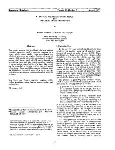
FIGURE 5.1 Haghia Triada open area: (a) plan of the propylon; (b) the Propylon in the current preservation state, from South; (c) the Stoa in the current preservation state, view from west.
5.5.1
Propylon
The first case study [54, 55] is relative to the open area (so called Piazzale Inferiore 10) directly connected to the building of power itself, the Villa, and linked with the facilities of the village, in a period between the seventeenth and fifteenth century BC (Figure 5.1). The excavations of the summer 2006 revealed on the north side the foundation of a very narrow and elongated rectangular room that served as a hub for the road from the village and therefore constituted a real propylon, whose function of monumental vestibule is confirmed by the large threshold still recognizable in situ, according to the constructive concept input of the precinct with an elegant entrance, popular choice in the Neopalatial period [56, 57]. The need to consider the overall organization of this sector of the monumental complex has been addressed by the 3D modeling technology, with the application of a philological approach, based on a thorough investigation of the fundamental characteristics of Minoan architecture [58,59] and of the repertoires represented on stone vessels [60] and on the frescoes [61, 62], all contemporary to the structures under study. In the middle of the north side of the open area stood the propylon which had its monumental face,
64
Radamante al computer. Archeologia e informatica...
FIGURE 5.2 3D reconstructive model of the open area between the village and the Villa with the virtual reconstruction of the Propylon, the fac¸ade of the Bastion and the Stoa.
probably, provided with a column, right-facing the open space and the Villa itself. The rear elevation provided a simple unaligned entrance, oriented to a gently sloping ramp that represented the main road of the village. The review of the archaeological evidence allowed reconstruction of the east side of the area, a sort of small stoa or porch [56, 57], with a second floor veranda facing the great paved road to the sea. In this case some artifacts documenting the characteristics of Minoan public and private buildings were fundamental (Figure 5.5.1).
5.5.2
House of the Razed Rooms
The other case study is represented by the so-called House of the Razed Rooms [42] (Figure 5.3). This house, built and used during the fourteenth century BC (late Minoan IIIA2), located in the north eastern part of the settlement, north of the Villa, was so deeply damaged by many subsequent activities that it became indispensable trying to create a virtual model to analyze its architectural phases [63]. Discovered by Federico Halbherr in
Experiencing the Past: Computer Graphics in Archaeology
65
1911, the House of Razed Rooms, built on two superimposed terraces, takes its name by the razing of the walls of the upper terrace, and the covering and the re-qualification of the structures of the lower one, carried out when a new plan of this area was designed in the second half of the fourteenth century, after the fall of the Knossos palace. After the excavation of 1991, when only the southern part of the building was uncovered, in 1983 V. La Rosa [64] completed the exploration of the house, discovering the complete plan with a main L-shaped corridor (n. 2) with two groups of modular rooms (n. 5, 6, 7 in the western side and n. 1, 3, 4 in the northern part). The corridor 2 had a floor of 1.50 m higher than the other six rooms, that were accessible through trapdoor from the top. The entire building had a length of 20.10 m in north/east-south/west sense and a surface of 180 m2 ; the walls had a thickness of 0.80-0.90 m with foundations on the rock. The plan, the thickness of the walls, and the absence of a direct connection between corridor 2 and the other rooms seem to suggest that probably this building did not have residential functions. Furthermore, the subdivision of the space in the same modular unities [65] is a feature, present in some contemporary buildings of Greece like Gla and Mycenae, that has to be interpreted as the mark of structures used as warehouses. In this context, it is possible to identify the two groups of rooms 1, 3, 4, and 5-7 of the House of the Razed Rooms as silos used probably for the long conservation of cereals and legumes [66]. The virtual model of the building (Figure 5.4) was very useful for many reasons [63] like the possibility of producing two different models of the House of the Razed Rooms, one of the actual state of the building (Figure 5.4(a)), as to create a digital replica of the monument to be used for virtual museum politics, and a second one presenting a picture of the House at the moment of its use (Figure 5.4(b)).
5.5.3
VAP House
Another evidence, datable to the Late Palatial period, is the monumental mansion with several building phases, that has been identified with the house of the local authority, called by Italian archaeologists “Casa dei Vani
66
Radamante al computer. Archeologia e informatica...
(a)
(b)
FIGURE 5.3 Haghia Triada, village: (a) multilayered plan with the House of Razed Rooms indicated in red; (b) house of the Razed Rooms in the current preservation state, view from south west.
(a)
(b)
FIGURE 5.4 (a) Virtual replica of the House of Razed Rooms; (b) architectural study of the wooden floor with trapdoors and of the roof beams system on the virtual model.
Experiencing the Past: Computer Graphics in Archaeology
(a)
(b)
67
(c)
FIGURE 5.5 Haghia Triada, village: (a) Multilayered plan with the VAP House indicated in red; (b) detailed plan of the VAP House; (c) VAP House in the current preservation state, view from south west.
Aggiunti Progressivamente” (VAP House, Figure 5.5.3) [47, 67]. The main peculiarity of this building is how it was progressively enlarged by means of single rooms. This process involved the transformation of the original outer walls into partition walls. Seven subsequent building phases, with the construction of a second floor, the progressive adjunction of rooms and open spaces, can be distinguished between LM IIIA2 early and LM IIIB. At the time of the abandonment of the site in LM IIIB, VAP House was a substantial building, with twelve rooms and one small court on the ground floor, and at least five more rooms on the first floor. The ground floor measured about 320 m2 , and the total extension, including the upper floor, was about 450 m2 . The few finds from the House (mostly some pithoi and a few other vessels) suggest that it was abandoned in a non-violent way and systematically emptied. A pyxis, a fragmentary pithos, and a clay stand of “snake tube” type were found in room A [68]. The latter was placed near the outer door of the room, beside the first step of the stair, and was probably used to hold cultic offerings. The construction of room A, in the fifth building phase, involved a functional reassessment of the lower floor space that was related to the new layout of the principal North-South road of the settlement, and to the
68
Radamante al computer. Archeologia e informatica...
creation of the largest open area of Haghia Triada, the so-called Agora. It probably became the most important living room of the House, due to its large dimensions (6.80 × 4.90 m) and its proximity to the Agora. The ceremonial function of room A is confirmed by the frescoes, representing processions with people taking offerings and animals for sacrifice [67]. They belong to a figurative cycle, endowed with a strong symbolical character, which was probably intended to mark the beginning of an entirely new era in the political history of the settlement, when it became the capital of a small state in south-central Crete [43]. Virtual reconstruction is a valuable visualization tool when a complex and multiphased architecture has to be documented. It provides a graphical support to reason about the building and to visually access hypotheses about the appearance in the several construction phases. The reconstruction of the visible walls, derived from the graphic and photographic documentation available, offers a global picture of the entire house in its last phase before abandonment. To recreate a visual image of its ancient life explains the past by means of experiencing it [46]. The digital restoration of the procession fresco (Figure 5.6), and the re-creation of the ceremonial ambient of room A, with the location of the snake tube (Figure 5.7) in its original position, is another useful interpretative tool. The virtual model of the building, derived from the graphic and photographic documentation available, offers a global picture of the entire house as it is conserved now, including the fresco in room A and the snake tube. The virtual reconstruction (Figure 5.5.3) is intended to show the hypotheses about the state of the building in its several phases. To this aim the rooms have been modeled on different 3D layers: the user may choose the epoch and only the layer with the structures present in that epoch will be visualized. This interactive use greatly supports discussion and formulation of the alternative reconstruction choices. The building model has been completed with a minimal set of objects and decoration. In particular, a 3D model of a snake tube has been realized from photographic references of the snake tube found in room A (Figure 5.7. The modeling has been done generating the tube as a revolution solid, deformed and completed with snake-like handles (Figure 5.7(b)). In addition to the 3D reconstruction, a parallel virtual restoration activity has been performed on
Experiencing the Past: Computer Graphics in Archaeology
(a)
(b)
69
(c)
FIGURE 5.6 Vap House, Room A: (a) Fragments of the procession fresco; (b) procession scene on the Haghia Triada Sarcophagus; (c) virtual color reconstruction of the procession fresco.
(a)
(b)
(c)
(d)
FIGURE 5.7 (a) The snake tube from the room A; (b) 3D model of the snake tube obtained with Image Base 3D modeling technique; (c) Room A, to the right the stairway to room B and the location point of the snake tube, to the left the wall with the procession fresco, view from north. (d) virtual model of the Room A with the snake tube in its original position.
70
Radamante al computer. Archeologia e informatica...
FIGURE 5.8 3D reconstructive model of the VAP House, view from south west.
the very fragmentary remains of the fresco that was once on the wall of room A (Figure 5.6).
5.6
Digital Restoration
The technique of 3D digital restoration of archaeological objects is perhaps the most common trend in interdisciplinary projects related to the interpretation and dissemination of archaeological knowledge. This is because of the potential that 3D has in subtracting the archaeological goods to the destructive effects of atmospheric agents, of pollution, of time, and, in some cases, of natural disasters and wars. The digital restoration is not only aimed to keep the archaeological goods from future risks, it is also suitable to return the conceptual and artistic integrity to monuments or complex objects, which in antiquity were considered as a unit and nowadays, for different reasons, are disassembled and divided between museums of different countries (a well known example is the complex of Parthenon sculptures [69]). It is also the chance to produce three-dimensional snapshots of specific phases of past life on the basis of the historical documentation of a monu-
Experiencing the Past: Computer Graphics in Archaeology
71
ment [70]. The digital restoration is also the virtual version of the physical restoration, which for practical or economic reasons can not be made [71], which aims to give back a true image of a fragmented reality and, in some cases, wrongly recomposed [72]. In the last decade, in all the projects of digital archeology and also of 3D digital restoration, the reverse engineering approach had a large application in the policies of promotion of cultural goods [73–76, 76]. The high-definition 3D laser scanner is an instrument that collects 3D data from a given surface or object in a systematic, automated manner, at a relatively high rate, in near real time using a laser ray to establish the surface coordinates. From a decade, this technology has been applied to archaeological research to construct geometric models with different characteristics [77, 78]. Most archaeological work has been carried out to digitize objects of an intermediate size, such as settlement structures, statues, and vessels. The most recent works have been focused on modeling structures during the excavation of archaeological sites, either of only one zone [11] or the complete ensemble [79]. These studies have been carried out from the ground surface or using helicopter and airplanes [80]. Traditional methods such as tapes and theodolites, and more modern technology such as total stations and GPS, provide accurate but relatively slow methods for gathering spatial data, and their use to scan small objects is not feasible. The possibility to obtain in a limited amount of time a virtual exact replica of reality makes the laser scanning method ideal for studies of 3D digital restoration, where the virtual recomposition of fragmented elements, both physically and narratively, is fundamental [81]. The Archeomatica Project team of researchers in this field has proposed integrating the Blenderbased 3D modeling and image-based 3D modeling with the laser scanning technique, in order to solve the possible data voids problems connected with complex scanning. The laser scanner hardware used is the relatively cheap Next Engine [82]. The choice was based essentially on the fact that it is very compact and handy, and then it proves to be very versatile especially when the objects to be scanned are placed in restricted spaces or cannot be removed. The case studies to test the 3D digital restoration, presented below, were chosen because they presented different levels of difficulty but also to demonstrate how the application of this technique has offered several new elements for the interpretation of objects and, sometimes, of their contexts.
72
5.6.1
Radamante al computer. Archeologia e informatica...
Minoan Model
A good example of research in which 3D graphics techniques are applied to the problem of fragmentation is represented by an enigmatic small clay model, only partially preserved, from the site of Phaistos in Crete (Figure 5.9(a)), dating from the mid-fourth millennium BC (Early Minoan I-II in terms of Minoan chronology). The model was recovered in the south east room of the so-called Western Bastion, located on the northwestern side of Piazzale I [83]. A recent analysis of the piece [84], long known but ignored as incomprehensible at first glance because of its poor state, has led to its interpretation as a figurative scene of a religious nature. This interpretation was supported by its digital restoration the experts of Archeomatica Project have carried out. Basing on the conservation status of the object, it was possible to suggest the presence of two distinct anthropomorphic figurines, which body and long arms with large hands were stretched on the ground, and of a couple of cylindrical objects in front of the figurines (Figure 5.9(c)). The good level of knowledge achieved in the field of Minoan religion, and the several iconographical comparisons also present in other classes of artifacts, has led scholars to interpret the scene represented by the model as a scene of adoration of betili, large phallic stone symbols considered as bearers of good fortune, by two female figures in accordance with the custom of the Minoan religion [85]. This insight was made explicit through the creation of a 3D model, basing for the iconography of the female figures missing, the well known statue of the goddess of Myrtos [86], which is contemporary to the Phaistos model.
5.7
Dealing with Image Data in Archaeology: New Perspectives
The future of virtual archaeology and of its applications in the field of research and promotion of archaeological goods seems to be linked in an unavoidable way to the evolution of the virtual reality (VR) environment [87].
Experiencing the Past: Computer Graphics in Archaeology
(a)
(b)
73
(c)
FIGURE 5.9 (a) Early Minoan clay model from Phaistos; (b) digital reintegration of the virtual model; (c) virtual version of the clay model.
The virtual reality allows the 3D visualization of concepts, objects, or spaces and their contextualization through the creation of a visual framework in which data is displayed. VR also enables interaction with data organized in 3D, facilitating the interaction between human, data, and information in order to enhance the sensorial perception [88]. It creates a virtual space that is a replica of the real space, where the information about every feature that constituted the different moments of life of the real space are “translated” in 3D data. The two crucial points of every project of VR are the selection of the informations (pictures, drawings, geometrical measures) and the choice of which facet of the original object’s nature must be captured and reconstructed. “Visual computer models should make clear their sources and the criteria on which they are based” [89]. From this point of view, VR is not a copy of the “reality,” but the representation of “one,” or, several “instances,” possibilities among others, various under different circumstances and contexts, even if it can offer a multilayered reality experience, a kind of digital surrogate of the real world [87]. It has the cohesive function of relating the raw data to the interpretation [35] and “the ability to get inside and walk around the reconstruction buildings gave a stronger feeling of enclosed space and volume, and enhance the sense of being there” [90]. The most im-
74
Radamante al computer. Archeologia e informatica...
portant limit in the mimetic ability of the past and present reality of the VR is, in fact, represented by the cultural formation of the authors of the project, that in many cases are archaeologists. Diverse point of view can, in fact, affect the selection of the informations and produce very different results in terms of visual image of the past [91]. In order to understand archaeological systems, much more than a visually “realistic” geometric model is needed. “Dynamism and interaction” are essential. A dynamic model is a model that changes in position, size, material properties, lighting, and viewing specification. If those changes are not static but respond to user input, we enter into the proper world of virtual reality, whose key feature is real-time (RT) interaction. Here real-time means that the computer is able to detect input and modify the virtual world “instantaneously” at user commands. By selectively transforming an object, that is, by interpolating shape transformations, archaeologists may be able to form an object hypothesis more quickly [92]. The next step, on the same research direction, is the realization of systems of virtual experience of the recreated past, beyond the physical limits of the personal computer. “To make an archaeological excavation simulation compatible with the dynamics of the learning environment, the user must be able to navigate within it without being entirely bound to specified pathways, as typified by menu-driven routines or the buttons and links of a hyperspace environment” [93]. One field where the scholars in archaeology and computer science are recently getting involved is augmented reality (AR) or enhanced reality (ER) environments. Augmented reality has been defined as the simultaneous acquisition of supplemental virtual data about the real world while navigating around a physical reality [94]. In an AR environment the computer provides additional information that enhances or augments the real world, rather than replacing it with a completely virtual environment [95]. One of the objectives of AR is to bring the computer out of the desktop environment and into the world of the user working with a three-dimensional application. In contrast to VR, where the user is immersed in the world of the computer, AR incorporates the computer into the reality of the user. The user can then interact with the real world in a natural way, with the computer providing information and assistance. It is then a combination of the real scene viewed by the user and a virtual scene generated by the computer that augments the scene with additional
Experiencing the Past: Computer Graphics in Archaeology
75
information. The virtual world acts as an interface, which may not be used if it provides the same experience as face-to-face communication. AR enables users to go “beyond being there” and enhance the experience in order to achieve both the full interpretation of the traces of the past and the developing of the best tool for the dissemination of their message [96]. An example of the potential of this technology applied to archaeology is the augmented reality-based cultural heritage On-site Guide, acronym ARCHEOGUIDE, that provides new ways of information access at Greek archaeological sites in a compelling, user-friendly way through the use of 3D-visualization, mobile computing, and multi-modal interaction [97, 98]. The potential of this approach in the future could be enhanced by investing much more in the five fundamental elements of an AR environment, namely virtuality (objects that don’t exist in the real world can be viewed and examined), augmentation (real objects can be augmented by virtual annotations), cooperation (multiple users can see each other and cooperate in a natural way), independence (each user controls his own independent viewpoint), and individuality (displayed data can be different for each viewer) [99]. In conclusion, the encouraging results of the application of the computer graphics 3D to the archaeological evidence has demonstrated that it is possible to use another “sense” do decrypt the traces of the past: “three-dimensional recreation of ancient life and visual images are an extremely means explaining the past because they allow us to experience it.”
Acknowledgments
These Archeomatica Project members have participated: G. Mercadante, S. Provvidenza, E. Sangregorio.
Radamante al computer. Archeologia e informatica...
76
Bibliography [1] E. B. W. Zubrow, “Digital Archaeology. A Historical Context,” in T. L. Evans, P. Daly (eds.), Digital Archaeology. Bridging Method and Theory, Routledge, London, 2006. [2] G. Vannini, “Informatica per l’Archeologia o Archeologia per l’Informatica?,” in Archeologia e Calcolatori, vol. 11, pp. 311–315, 2000. [3] P. Daly and T. L. Evans, “Archaeological Theory and Digital Pasts,” in T.L. Evans, P. Daly (eds.), Digital Archaeology. Bridgind Method and Theory, Routledge, London, 2006. [4] H. Eiteljorg, Archaeological Computing. II edition, Center for the Study of Architecture, Bryn Mawr, 2008. [5] T. Orlandi, “Archeologia Teorica e Informatica Archeologica. Un Rapporto Difficile,” in Archeologia e Calcolatori, vol. 15, pp. 41–50, 2004. [6] M. Forte and R. Beltrami, “A Proposito di Virtual Archaeology: Disordini, Interazioni Cognitive e Virtualit`a,” in Archeologia e Calcolatori, vol. 11, pp. 273–300, 2000. [7] P. Reilly, “Towards a Virtual Archaeology,” in K. Lockyear, S. Rahtz (eds.), Computer Applications and Quantitative Methods in Archaeology, BAR International Series 565, Oxford, 1990. [8] M. Cultraro, F. Gabellone, and G. Scardozzi, “The Virtual Musealization of Archaeological Sites: Between Documentation and Comunication,” in F. Remondino, S. El-Hakim, L. Gonzo (eds.), Proceedings of the 3rd ISPRS International Workshop 3D-ARCH 2009 “3D Virtual Reconstruction and Visualization of Complex Architectures”, Trento, Italy, 25-28 February 2009, International Archives of
Experiencing the Past: Computer Graphics in Archaeology
77
Photogrammetry, Remote Sensing and Spatial Information Sciences, vol. XXXVIII-5/W1, 2009. [9] M. Cultraro, F. Gabellone, and G. Scardozzi, “Integrated Methodologies and Technologies for the Reconstructive Study of Dur-Sharrukin (Iraq),” in F. Remondino, S. El-Hakim, L. Gonzo (eds.), Proceedings of the 3rd ISPRS International Workshop 3D-ARCH 2009 “3D Virtual Reconstruction and Visualization of Complex Architectures”, Trento, Italy, 25-28 February 2009, International Archives of Photogrammetry, Remote Sensing and Spatial Information Sciences, vol. XXXVIII-5/W1, 2009. [10] V. Stojakovic and B. Tepavcevica, “Optimal Methods for 3D Modeling of Devastated Architectural Objects,” in F. Remondino, S. ElHakim, L. Gonzo (eds.) Proceedings of the 3rd ISPRS International Workshop 3D-ARCH 2009 “3D Virtual Reconstruction and Visualization of Complex Architectures”, Trento, Italy, 25-28 February 2009, International Archives of Photogrammetry, Remote Sensing and Spatial Information Sciences, vol. XXXVIII-5/W1, 2009. [11] M. Doneus and W. Neubauer, “ Laser Scanners for 3D Documentation of Stratigraphic Excavations,” in M. Baltsavias, A. Gruen, L. Van Gool, M. Pateraki (eds.), Recording, Modeling and Visualization of Cultural Heritage, London, Taylor and Francis, 2006. [12] M. Peripimeno, “Rilievo di Monumenti e Stratigrafie. L’Uso del Laser Scanner,” in V. Fronza, A. Cardini, M. Valenti (eds.), Informatica e Archeologia Medievale. L’esperienza senese, All’Insegna del Giglio, Siena, pp. 111–129, 2009. [13] T. E. Levy and N. G. Smith, “On-site Digital Archaeology: Gis-based Excavation Recording in Southern Jordan,” in T. E. Levy, M. Daviau, R. Younker, M. M. Shaer (eds.), Crossing Jordan. North American Contributions to the Archaeology of Jordan, Equinox, London, pp. 47– 58, 2007.
78
Radamante al computer. Archeologia e informatica...
[14] S. Moser, “Archaeological Representation. The virtual Conventions for Constructing Knowledge about the Past,” in I. Hodder (ed.), Archaeological Theory Today, Polity Press, Malden, 2005. [15] D. Pletinckx, “Virtual Archaeology as an Integrated Preservation Method,” in Arqueologica 2.0, Proceedings of 1st International Meeting on Graphic Archaeology and Informatics, Cultural Heritage and Innovation, Seville 17-20 June 2009, pp. 51–55, 2009. [16] N. Toganidis, “Parthenon Restoration Project,” in A. Georgopoulos, N. Agriantonis (eds.), AntiCIPAting the Future of the Cultural Past, Proceedings of the XXI International CIPA Symposium, Athens, pp. 1– 6, 2007. [17] F. Niccolucci, “Virtual Museums and Archaeology: an International Perspective,” in Archeologia e Calcolatori, suppl. 1, pp. 15–30, 2007. [18] E. Bacci, S. Boni, T. Canonici, V. D. Pozzo, and A. Ribatti, “L’utilizzo della Ricostruzione nella Comunicazione del Patrimonio Archeologico. L’Approccio, il Metodo, le Finalit`a e Alcuni Spunti di Discussione,” in Arqueologica 2.0, Proceedings of 1st International Meeting on Graphic Archaeology and Informatics, Cultural Heritage and Innovation, Seville 17-20 June 2009, pp. 405–409, 2009. [19] F. Antinucci, “The Virtual Museum,” in Archeologia e Calcolatori, suppl. 1, pp. 79–86, 2007. [20] http://www.virtualmuseumiraq.cnr.it [21] S. Chiodi, “Iraq Project: The Virtual Museum of Baghdad,” in Archeologia e Calcolatori, suppl. 1, pp. 101–122, 2007. [22] F. Gabellone and G. Scardozzi, “From Object to the Territory: Imagebased Technologies and Remote Sensing for the Recostruction of Ancient Contexts,” in Archeologia e Calcolatori, suppl. 1, pp. 123– 142, 2007.
Experiencing the Past: Computer Graphics in Archaeology
79
[23] P. Bellintani and L. Moser, Archeologie Sperimentali - Metodologie ed Esperienze fra Verifica, Riproduzione, Comunicazione e Simulazione, Atti Convegno Comano Terme - Fiav´e (Trento - Italy). 2003. [24] G. Thomas, Experimental Archaeology, Routledge, London, 2009. [25] L. Longo, “Archeologia Sperimentale, Esperimenti in Archeologia, Divulgazione. Osservazioni su Significato e Ruolo dell’Archeologia Sperimentale,” in Rivista Scienze Preistoriche, vol. LIII, pp. 549–568, 2003. [26] J. Coles, Archeologia sperimentale. Longanesi, Milano, 1981. [27] M. Moser, S. Hye, G. Goldenberg, K. Hanke, and K. Kovacs, “Digital Documentation and Visualization of Archaeological Excavations and Finds Using 3D Scanning Technology,” in Arqueologica 2.0, Proceedings of 1st International Meeting on Graphic Archaeology and Informatics, Cultural Heritage and Innovation, Seville 17-20 June 2009, pp. 351–355, June 2009. [28] D. C. Dennett, “Seeing is believing,” in K. Akins (ed.), Perception, Vancouver Studies in Cognitive Science, Oxford University Press, vol. 5, pp. 158–172, 1996. [29] B. Frischer, “Art and Science in the Age of Digital Reproduction: From Mimetic Representation to Interactive Virtual Reality,” in Arqueologica 2.0, Proceedings of 1st International Meeting on Graphic Archaeology and Informatics, Cultural Heritage and Innovation, Seville 17-20 June 2009, pp. 35–48, June 2009. [30] http://www.archeomatica.unict.it [31] http://iplab.dmi.unict.it [32] D. Margounakis, “ Virtual Reconstructions in Archaeology,” in D. Politis (ed.), E-Learning Methodologies and Computer Applications in Archaeology, 2008.
80
Radamante al computer. Archeologia e informatica...
[33] E. F. Anderson, L. McLoughlin, F. Liarokapis, C. Peters, P. Petridis, and S. de Freitas, “Serious Games in Cultural Heritage,” in M. Ashley, F. Liarokapis (eds.), Procedings of the 10th International Symposium on Virtual Reality, Archaeology and Cultural Heritage VAST, State of Arts and Reports, pp. 29–48, 2009. [34] F. Salvadori, “Modellazione dei Reperti,” in V. Fronza, A. Cardini, M. Valenti (eds.), Informatica e Archeologia Medievale. L’esperienza senese, All’Insegna del Giglio, pp. 131–147, Siena, 2009. [35] P. Reilly, “Three Dimensional modeling and Primary Archaeological Data,” in P. Reilly, S. Rahtz (eds.), Archaeology and the Information Age. A global perspective, 1992. [36] http://www.blender.org [37] F. Remondino and S. El-Hakim, “ A Critical Overview of Imagebased 3D Modeling,” in M. Baltsavias, A. Gruen, L. Van Gool, M. Pateraki (eds.), Recording, Modeling and Visualization of Cultural Heritage, London, Taylor and Francis. [38] F. Verbiest, G. Willems, D. Pletincky, and L. V. Gool, “Image-based Rendering of Cultural Heritage,” in M. Baltsavias, A. Gruen, L. Van Gool, M. Pateraki (eds.), Recording, Modeling and Visualization of Cultural Heritage, London, Taylor and Francis. [39] I. Roussos and A. Chalmers, “High Fidelity Lighting of Knossos,” in D. Arnold, A. Chalmers, F. Niccolucci (eds.), 4th International Symposium on Virtual Reality, Archaeology and Intelligent Cultural Heritage, VAST, pp. 195–201, 2003. [40] R. Ercek, D. Viviers, and N. Warz´ee, “3D Reconstruction and Digitalization of an Archaeological Site, Itanos, Crete,” in Arqueologica 2.0, Proceedings of 1st International Meeting on Graphic Archaeology and Informatics, Cultural Heritage and Innovation, Seville 17-20 June 2009, pp. 289–294, 2009.
Experiencing the Past: Computer Graphics in Archaeology
81
[41] K. Papadopoulos and G. P. Earl, “Structural and Lighting Models for the Minoan Cemetery at Phourni, Crete,” in Perlingieri, C. and Pitzalis, D. (eds.), Proceedings of the 10th International Symposium on Virtual Reality, Archaeology and Cultural Heritage VAST, pp. 57– 64, 2009. [42] V. La Rosa, “ La ‘Villa Royale’ d’Haghia Triada,” in R. H¨agg (ed.), The Function of the ‘Minoan Villa’, Astrom editions, 1997. ´ [43] V. La Rosa, “ Haghia Triada a` l’Epoque Myc´enienne: l’Utopie d’une Ville Capitale,” in J. Driessen, A. Farnoux (eds.), La Cr`ete Myc´enienne (BCH Suppl. 30), De Boccard, 1997. [44] P. Rehak and J. Younger, “Review of Aegean Prehistory VII : Neopalatial, Final Palatial, and Postpalatial Crete,” in T. Cullen (a cura di), Aegean Prehistory, A Review, Boston, Archaeological Institute of America, 2001. [45] J. Bennet, “The Structure of the Linear B Administration at Knossos,” in American Journal of Archaeology, vol. 89, pp. 231–249, 1985. [46] J. Driessen, “Centre and Periphery: some Observations on the Administration of the Kingdom of Knossos,” in S. Voutsaki, J. Killen (ed.), Economy and Politics in the Mycenaean Palace States, Cambridge, Cambridge Philological Society, 2001. [47] S. Privitera, “Looking for a Home in a Houseless Town: Domestic Architecture at Final Palatial Hagia Triada,” in K. Glowacki, N. Vogeikoff-Brogan (eds.), The Archaeology of Houses and Households in Ancient Crete, in press. [48] V. La Rosa, “Il Colle sul quale sorge la Chiesa ad Ovest e` tutto Seminato di Cocci. Vicende e Temi di uno Scavo di Lungo Corso,” in Creta Antica, vol. 4, pp. 11–68, 2003. [49] http://digitalcrete.ims.forth.gr
82
Radamante al computer. Archeologia e informatica...
[50] A. Sarris, V. Trigkas, G. Papadakis, M. Papazoglou, E. Peraki, N. Chetzogiannaki, M. Elvanidou, E. Karimali, K. Kouriati, M. Katifori, G. Kakoulaki, E. Kappa, K. Athanasaki, and N. Papadopoulos, “A web gis Approach for the Cultural Resources Management of Crete: The Digital Archaeological Atlas of Crete,” in A. Posluschn, K. Lambers, I. Herzog (eds.), Layers of Perception. Proceedings of the 35th International Conference on Computer Applications and Quantitative Methods in Archaeology (CAA), 2008. [51] D. Gutierrez, V. Sundstedt, F. Gomez, and A. Chalmers, “Dust and Light: Predictive Virtual Archaeology,” in Journal of Cultural Heritage, vol. 8, pp. 209–214, 2007. [52] J. Happa, M. Mudge, K. Debattista, A. Artusi, A. Gonalves, and A. Chalmers, “Illuminating the Past - State of Art,” in M. Ashley, F. Liarokapis (eds.), Procedings of the 10th International Symposium on Virtual Reality, Archaeology and Cultural Heritage VAST, State of Arts and Reports, pp. 9–28, 2009. [53] http://radsite.lbl.gov/radiance [54] E. Sangregorio, F. Stanco, and D. Tanasi, “The Archeomatica Project: Towards a new Application of Computer Graphics in Archaeology,” in Proceedings of 6th Eurographics Italian Chapter Conference, pp. 1–5, July 2008. [55] F. Stanco and D. Tanasi, “La Computergrafica nella Ricerca Archeologica. Dal 3D Modeling alla Digital Archaeology,” in Proceedings of V Congresso Nazionale di Archeometria, pp. 605–617, 2009. [56] V. La Rosa, “Considerazioni sull’Area ad Ovest del c.d. Bastione ad Haghia Triada,” in ASAtene LXXXIV, s. III, 6, tomo II, pp. 819–877, 2006. [57] P. Militello, “Un nuovo Propylon ad Haghia Triada e gli Spazi Recintati nella Creta Neopalaziale,” in Creta Antica, vol. 9, pp. 11–18, 2008.
Experiencing the Past: Computer Graphics in Archaeology
83
[58] L. A. Hitchcock, Minoan Architecture. A Contextual Analysis. Astrom editions, 2000. [59] J. W. Shaw, Minoan Architecture: Materials and Techniques, (Studi di Archeologia Cretese), Aldo Ausilio Editore, vol. VII, Padova, 2009. [60] P. Warren, Minoan Stone Vases. Cambridge University Press, 1969. [61] M. Hue, “ Les Repr´esentations Architecturales dans la Peinture Mu´ eenne de l’Age du Bronze: l’Exemple d’Akrotiri (Thera),” in rale Eg´ ´ Etienne R., Le Dinahet M., Yon M. (eds.) Architecture et po´esie dans le monde grec: hommage a` George Roux, Maison de l’Orient, 1989. ´ een du IIe Mill´enaire Av. [62] C. Boulotis, “Villes et Palais dans l’Art Eg´ J.-C.,” in Darcque P., Treuil R., De Boccard (eds.) L’habitat e´ g´een pr´ehistorique, 1990. [63] F. Stanco and D. Tanasi, “Reconstructing the Past: il 3D Modeling nella Ricerca Archeologica,” in L. Bezzi, D. Francisci, P. Grossi, D. Lotto (eds.), Atti del 3 Workshop Open Source, Free Software e Open Format nei processi di ricerca archeologica, 2008. [64] V. La Rosa, “Recenti Acquisizioni nel Settore Nord dell’Abitato di Haghia Triada,” in Atti VI Congr. Intern. Studi Cretesi, pp. 411–418, 1990. [65] P. Darcque, L’Habitat Myc´enien. Formes et Fonctions de l’Espace Bati en Gr`ece Continentale a` la Fin du IIe Mill´enaire Avant J.-C. De Boccard, 2006. [66] F. Sigaut, “A Method for Identifying Grain Storage Techniques and its Application for European Agricultural History,” in Tools and Tillage, vol. 6, pp. 3–32, 1998. [67] S. Privitera, “The LM III Frescoes from the Villaggio at Hagia Triada: New Observations on Context and Chronology,” in Creta Antica, vol. 9, pp. 111–137, 2008.
84
Radamante al computer. Archeologia e informatica...
[68] G. Gesell, “The Minoan Snake Tube. A Survey and Catalogue,” in American Journal of Archaeology, vol. 80, pp. 247–259, 1976. [69] J. Stumpfel, C. Tchou, T. Hawkins, P. M. B. Emerson, M. Brownlow, A. Jones, N. Yun, and P. Debevec, “Digital Reunification of the Parthenon and its Sculptures,” in D. Arnold, A. Chalmers, F. Niccolucci (eds.), 4th International Symposium on Virtual Reality, Archaeology and Intelligent Cultural Heritage, VAST, pp. 1–10, 2003. [70] G. Bitelli, V. A. Girelli, M. Marziali, and A. Zanutta, “Use of Historical Images for the Documentation and the Metrical Study of Cultural Heritage by Means of Digital Photogrammetric Techniques,” in A. Georgopoulos, N. Agriantonis (eds.), AntiCIPAting the Future of the Cultural Past, Proceedings of the XXI International CIPA Symposium, pp. 1–6, 2007. [71] A. C. R. Eppich, “Recording and Documenting Cultural Heritage 3D Modeling for Conservation in Developing Regions,” in M. Baltsavias, A. Gruen, L. Van Gool, M. Pateraki (eds.), Recording, Modeling and Visualization of Cultural Heritage, London, Taylor and Francis, pp. 11–20. [72] http://formaurbis.stanford.edu, “Stanford Digital Forma Urbis Romae Project,” [73] M. Callieri, P. Cignoni, F. Ganovelli, G. Impoco, C. Montani, P. Pingi, and R. S. F. Ponchio, “Visualization and 3D Data Processing in David’s Restoration,” in IEEE Computer Graphics and Applications archive vol. 24, Issue 2, pp. 16–21, March/April 2004. [74] V. Valzano, A. Bandiera, and J. A. Beraldin, “Realistic Representations of Cultural Heritage Sites and Objects Through Laser Scanner Information,” in Proceedings of 10th International Congress “Cultural Heritage and new Technologies”. Vienna, Austria, November 2005. [75] J. Ristevski, “Feature: Laser Scanning for Cultural Heritage Applications,” in Professional Surveyor vol. 26, November 2006.
Experiencing the Past: Computer Graphics in Archaeology
85
[76] T. Abmayr, F. Hartl, M. Reinkoster, and C. Frohlich, “Terrestrial Laser Scanning- Applications in Cultural Heritage Conservation and Civil Engineering,” in Proceedings of ISPRS Congress 2008, vol. XXXVII, 2008. [77] D. Peloso, “Tecniche Laser Scanner per il Rilievo dei Beni Culturali,” in Archeologia e Calcolatori, vol. 16, pp. 199–224, 2005. [78] W. Boeheler, “Comparison of 3D Laser Scanning and other 3D Measurement techniques,” in M. Baltsavias, A. Gruen, L. Van Gool, M. Pateraki (eds.), Recording, Modeling and Visualization of Cultural Heritage, London, Taylor and Francis, pp. 89–100, 2006. [79] T. Gaisecker, “Pinchango Alto. 3D Archaeology Documentation using the Hybrid 3D Laser Scan System of RIEGL,” in M. Baltsavias, A. Gruen, L. Van Gool, M. Pateraki (eds.), Recording, Modeling and Visualization of Cultural Heritage, London, Taylor and Francis, 2006. [80] M. Doneus, C. Brieseb, M. Feraa, U. Fornwagnera, M. Griebla, M. Jannera, and M. C. Zingerlea, “Documentation and Analysis of Archaeological Sites using Aerial Reconnaissance and Airborne Laser Scanning,” in A. Georgopoulos, N. Agriantonis (eds.), AntiCIPAting the Future of the Cultural Past, Proceedings of the XXI International CIPA Symposium, pp. 1–6, 2007. [81] K. Cain, C. Sobieralski, and P. Martinez, “Reconstructing a Colossus of Ramesses II from Laser Scan Data,” in ACM SIGGRAPH 2003 Sketches & Applications, (New York, NY, USA), pp. 1–1, ACM, 2003. [82] http://www.nextengine.com [83] F. Carinci and V. La. Rosa, “Revisioni Festie II,” in Creta Antica, vol. 10/I, pp. 147–300, 2009. [84] V. La Rosa, “A new EM Clay Model from Phaistos,” in O. Krzyszkowska ed., Cretan Offerings, Studies in Honour of Peter Warren (BSA Suppl. Studies), Vol. 18, pp. 189-194, London 2010.
86
Radamante al computer. Archeologia e informatica...
[85] M. Gallo, “Per una Riconsiderazione del Betilo in Ambito Minoico,” in Creta Antica, vol. 6, pp. 47–58, 2005. [86] P. Warren, Myrtos: An Early Bronze Age Settlement in Crete. British School of Archaeology at Athens. Supplementary volume, no. 7, 1972. [87] M. Mudge, M. Ashley, and C. Schroer, “A digital Future for Cultural Heritage,” in A. Georgopoulos, N. Agriantonis (eds.), AntiCIPAting the Future of the Cultural Past, Proceedings of the XXI International CIPA Symposium, pp. 1–6, 2007. [88] S. Hermon and L. Kalisperis, “Between the Real and the Virtual: 3D Visualization in the Cultural Heritage Domain - Expectations and Prospects,” in Arqueologica 2.0, Proceedings of 1st International Meeting on Graphic Archaeology and Informatics, Cultural Heritage and Innovation, Seville 17-20 June 2009, pp. 99–103, June 2009. [89] F. Niccolucci, “Virtual Archaology: an Introduction,” in F. Niccolucci (ed.), Virtual Archaeology, Proceedings of the VAST Euroconference, Arezzo 24-25 November 2000, BAR I.S. 1075, Oxford, Archaeopress, pp. 3–6, 2002. [90] J. Wood and G. Chapman, “Three Dimensional Computer Visualization of Historic Buildings,” in P. Reilly, S. Rahtz (eds.), Archaeology and the Information Age. A global perspective, London-New York, 1992. [91] A. Coralini and E. Vecchietti, “L’archeologia attraverso un Virtual Model,” in A. Coralini, D. Scagliarini Corl`aita (eds.), Ut Natura Ars. Virtual Reality ed Archeologia, Atti della Giornata di Studi, University Press Bologna, Imola, pp. 17–40, 2002. [92] J. Barcel, “Virtual Reality for Archaeological Explanation Beyond ‘Picturesque’ Reconstruction,” in Archeologia e Calcolatori, vol. 12, pp. 221–244, 2001.
Experiencing the Past: Computer Graphics in Archaeology
87
[93] B. Molyneaux, “From virtuality to Actuality: the Archaeological Site Simulation Environment,” in P. Reilly, S. Rahtz (eds.), Archaeology and the Information Age. A global perspective, London-New York, 1992. [94] P. Milgram and S. Yin, “An Augmented Reality Based Teleoperation Interface for Unstructured Environments,” in ANS 7th Meeting on Robotics and Remote Systems, Augusta, pp. 101–123, 1997. [95] N. Magnenat-Thalmann and G. Papagiannakis, “Virtual Worlds and Augmented Reality in Cultural Heritage Applications,” in M. Baltsavias, A. Gruen, L. Van Gool, M. Pateraki (eds.), Recording, Modeling and Visualization of Cultural Heritage, London, Taylor and Francis. [96] M. Billinghurst and H. Kato, “Collaborative Mixed Reality,” in Proceedings of the First International Symposium on Mixed Reality (ISMR ’99). Mixed Reality - Merging Real and Virtual Worlds, Berlin, Springer Verlag, pp. 261–284, 1999. [97] V. Vlahakis, N. Ioannidis, J. Karigiannis, M. Tsotros, M. Gounaris, D. Stricker, T. Gleue, P. Daehne, and L. Almeida, “Archeoguide: Challenges and Solutions of a Personalized Augmented Reality Guide for Archaeological Sites,” in IEEE Computer Graphics and Applications, vol. 22, no. 5, pp. 52–60, 2002. [98] D. Stricker, A. Pagani, and M. Zoellner, “In-situ Visualization for Cultural Heritage Sites using Novel, Augmented Reality Technologies,” in Arqueologica 2.0, Proceedings of 1st International Meeting on Graphic Archaeology and Informatics, Cultural Heritage and Innovation, Seville 17-20 June 2009, pp. 141–145, June 2009. [99] D. Schmalsteig, A. Fujrmann, Z. Zalavari, M. Gervautz, and E. Studierstube, “An Environment for Collaboration in Augmented Reality,” in CVE ’96 Workshop Proceedings, Nottingham, September 1996.