UCTEA International Geographical Information Systems Congress 2017, 15-18 November 2017, Adana, Turkey.
Hierarchical Blockchain Architecture for a Relaxed Hegemony on Cadastre Data Management and Update: A Case Study for Turkey Abdulvahit Torun Aperigae Information Technologies Consulting, GMK Bulvarı 12-128, 06650 Kızılay, Ankara, Turkey.
Abstract In Today’s globalized and highly democratized and decentralized geospatial data environment, there are multiple data owners and multiple parties claim different levels of authority on the data. In such an environment, a complete, correct and consistent data could only be created and maintained by collaborative management and mutually reconciled workflows where a new data sharing, decentralized data approving, quality assurance and data delivery model and mechanism needed. Eventually, geospatial data owned by multiple institutes and even individuals force the conventional ownership and definitions of property rights to be adapted according to new environment. In this study, a problem of inconsistent boundary determination in between succeeding cadastre surveys is introduced and a methodology based on hierarchical blockchain architecture is proposed which may prevent such cases. In the proposed methodology, a transaction of boundary change is not booked in the land registry, unless common and joint approval of all stakeholders. After presenting a case study of two separate physical boundaries which are represented as a unique edge in the cadastre data, in Kırşehir/Turkey, a CAD/GIS enabled methodology based on blockchain technology is proposed to prevent such occasions. In the proposed approach, the landowners are participating as an equal partner in the cadastre survey and decision making process. The ‘GIS Engine for Cadastre Data Management’ part of the ‘Spatio-temporal GIS/CAD Engine’ component of Land Registry & Cadastre (LR&C) Blockchain (BC) Node is designed and implemented by using C# and ESRI ArcObjects SDK for .NET and libraries of ArcObjects COM components and an open library of NewtonSoft.JSON. Keywords Cadastre, Land registry, Surveying, Boundary, Blockchain, GIS, CAD, Database
1. Introduction The physical representation of the defined rights in the registry has been maintained in peace by the stakeholders namely owners of the properties and the state authority -usually- namely an organization of land registry and cadastre, unless any of the participants agree on written formal documents and physical reality. Despite, new technology provides sub-centimeter accuracy to determine the boundary and extent of properties and land, usually a discrepancy between layout of documented coordinates, edges, areas with the physical reality. Many of the countries, handle and manage land registry and cadastre data separately to prevent an occurrence of conflict between legislation and modern cadastre surveys. In this study, a geospatial data enabled blockchain model comprising three components, namely ‘blockchain database’, ‘middleware’ and ‘GIS/CAD’. These tree components are loosely coupled. the ‘blockchain database’ component handles the communication and trace of transactions, ‘the middleware’ component handles the relationship and communication between ‘blockchain database’ and ‘the GIS/CAD’ in a lossless geo and non-geo data transaction and ‘the GIS/CAD’ component handles the geometrical part. In the ‘blockchain database’ component which is the hierarchical blockchain architecture, there are three levels in a hierarchy to control and mutually decide on any transaction by approval of relevant participants in accordance with the land registry and cadastre organization as a trusted node watching the procedures. 1.1. Related Work Vos (2016) and Dijkstra et.al (2015) reported examples of blockchain research and application on land registry from Sweden, Georgia, Honduras and Ghana. Meanwhile, Vos (2016), gives a structural approach for land registry transaction processes and how blockchain fits with them. Dijkstra et.al (2015) states that, blockchain technology is suitable for land registry and cadastre. Chachkhunashvili (2016) states that National Agency of Public Registry NAPR of Georgia has started the use of blockchain approach for land property transaction. Bal (2016) reports the international efforts on blockchain studies as well as a view of Indian Registry from the perspective of potential benefits. The LantmaterietSweden (2016) reports, a conducted project which covers Today’s land registry and real estate transactions and a pilot project to create an application that would use blockchain technology to facilitate transactions which is mutually executed by several stakeholders such as real estate agent, bank, buyer, seller, and the Lantmateriet. In our study, despite the available studies are all concentrated on land registry, ours is on surveying methodology and the surveying technology, projects and applications. This study aims at using blockchain technology to minimize the
* Corresponding Author: Tel: +90 (533) 5117503 Fax: +90 (312) 4250320 E-mail:
[email protected] (Torun A.)
Hierarchical Blockchain Architecture for a Relaxed Hegemony on Cadastre Data Management and Update: A Case Study for Turkey
boundary surveying problems caused by incautious considerations in order to minimize the mistakes that cause unsolvable problems at cadastre surveying phase and has to be handled at cadastre courts. 1.2. Scope of the Work Within the scope of this study, a three component and hierarchical -three levels- blockchain architecture is presented, as well as a database model, data structures, algorithms that runs as a parallel process along land registry transaction database which runs on blockchain technology. In this study we only handle one component namely ‘Temporal GIS/CAD Engine for Land Registry and Cadastre of Blockchain’. Although the functionalities and participation in the proposed architecture are given in the paper for completeness, the other two components -Blockchain Transaction Engine and Middleware- will be handled and implemented separately.
2. The Cadastre System of Turkey and Cadastral Survey Campaigns Countries survey and maintain the physical view of their territories and cadastre for use of large communities in addition to public works and private sector needs in the form of maps or digital data. The governmental institutions, private sector, academia, real estate sector largely use cadastral data for multiple purposes such as planning, land management, utility, risk assessment. 2.1. Turkish Cadastre System and the Legislation The history of cadastral legislation in Turkey started in 1847 by establishing the first Land Registration Organization’; in 1924 ‘General Directorate of Title Deed’ (Law # 658) was founded; in 1934 modern cadaster works started in urban areas with ‘the law of Registry and Cadastre’ (Law # 2613) followed by another ‘Cadastre Law’ for cadaster of rural areas in 1950 (Law # 5602); the law in 1987 (Law # 3402) described a unique cadaster for urban and rural, a type of public announcement replaced the announcement relevant bodies to save cadastre expenses, as well as a very detailed definition of how cadaster would be conducted in practice, in addition to new technical concepts such as ‘spatial databases’. With some ratifications on Law # 3402 in recent years, ‘General Directorate of Land Registry and Cadastre-GDLRC’ is conducting both ‘land registry’ and ‘cadastre’ works and keeping ‘land registry books’ regularly under the same organizational frame despite the similar cadastre systems such as German and Dutch. Turkish Cadaster System, being based on ‘legal system’ also aims at taxation, maintaining the cadastral maps and data updated for governmental, private and individual users (Gruber et.al., 2014; Jones, 2012; Cete, 2014; Demir et.al, 2008; GIM, 2007; TKGM, 2008; Yaşayan et.al., 2011; TKGM, 1987). In Turkish Cadastral System, title for each parcel is registered in the ‘registration book’ with the information of landowner, legal position of person/parsons regarding the parcel, legal rights of person/persons to use the property and a link to parcel geometry described in the cadaster data which has a unique ID number that binds cadaster and land registry. 2.2. Establishing the Base Cadastre of Turkey With attempts of her own capabilities in the first years, after the National Assembly made the law number 3402 in 1987, the GDLRC started a campaign to establish up-to-date, digital, modern, survey based cadastre with modern techniques with outsourcing the cadaster survey to newly growing private surveying sector. Starting from 2005, great efforts made by GDLRC and private sector as contractor resulted completion of ‘Base Cadaster Surveys’ by the end of 2012. In the ‘Cadastre Campaign’ of ten years of effort, 14.5 Million cadastre parcels out of the total number of 57.5 Million has been surveyed, registered and put in digital databases with a total contracting cost of USD 427 Million excluding the costs of GDLRC in house and with an approximate cost of USD 34.01 per parcel (TKGM, 2017_1; TKGM, 2017_2). The lack of large scale cadastre data in urban, near urban and along the corridors of infrastructure routes, forced other governmental institutes such as Directorates of ‘Water Works’, ‘Roads’, ‘Rail Roads’, ‘Urban Development’ to produce their own large scale ‘as-is maps’ –with an almost equal content of large scale cadastre data- multiple times at the same locations. Compliance, edge matching, integration, finding the most current, maintenance and management of cadastre data created by GDLRC and other governmental institutions is a hot problem to be resolved to meet the needs of developing Turkish Economy with limited resources, preparing the country for 3D/4D Cadastre as well as compliance with INSPIRE and national SDI initiatives and goals stated in FIG Cadastre 2014 (FIG, 2017; ISO 19152, 2012). 2.3. The Updating Needs for Cadastre Data Due to the increasing cultural developments through whole country and results of some investigations on technical and legal aspects of the ‘Cadastre Campaign’ emerged the need for update for cadastre with problems which has been approved in very limited case of the Law # 3402. Since then, there has been a campaign of so called ‘Updating due to 22-
Abdulvahit Torun
a’ which has been partly financed by a USD 203 Million of long term credit under contract with World Bank. The experienced cadastral update which exceeds far beyond the ‘parcels with technical surveying problems’ creates a new cadastre data set which only could be a very relaxed legal interpretation of Civil Code (Law # 4721) and Cadastre Law (Law # 3402) (TKGM, 2016; Sarı, 2017; Toker, 2016; Kaya, 2003). 2.4. Analysis of Court Cases on Cadastre The mistakes, observation errors, evaluation errors made by field team cause further disputes as the registration done. In many cases, these mistakes are recognized when a property is to be sold third person whom wants the property to be shown and measured in the field. Dissolving the disputes are quite difficult by the courts after several years where limited data is stored. As the base cadastre works populated the geospatial attributes in land registry, the landowners whom are aware of the change raised their claim during the announcement time or applied the court to resolve the dispute case. During and after the extensive cadastre survey campaign, the increasing tendency of the number of cases stated in the cadastre courts, is declining in the last 5 years. These statistical data are concerning the cadastre courts whereas the cases about claims on land registry are evaluated. On the other hand, the statistics about the claims concerning the objection for cadastral surveys just after the announcement of cadastre survey that are handled by other courts - not called cadastre courts- are not depicted in the graphic, because of lack of information. Starting from 2005, about 370000 cases has been conducted in Cadastre Courts with a decreasing trend until 2015.
3. The Blockchain Technology and Its Applications on Land Registry and Cadastre The aim of using blockchain in cadastre is introducing the landowner participation into the boundary determination process which causes conflicts. Despite the centralized systems controlled by a single authority for land registry, blockchain technology provides a revolutionary system and solution having the characteristics such as decentralization, openness, transparent for booking land registry with assured legal guarantee for transactions of property rights. 3.1. Blockchain Technology The specifications of blockchain technology makes it useable for registering such as land registry for land parcels and properties (Vos, 2016; Dijkstra et.al., 2015; Chachkhunashvili, 2016; Lantmateriet-Sweden, 2016). The blockchain architecture is a network of nodes. Each node has same or defined rights for corresponding transactions to be executed as approval of all relevant nodes. All the information about accomplished or non-ended transactions are maintained in all relevant nodes in chains of blocks. Any manipulation such as creation of updating of a transaction needs to be approved by relevant nodes/participants with their cryptography (ID and KEY). In this way, the transaction is executed and the registry (ledger) is updated in a safe way without a central authority. Even if a node disappears or quits from the system, the registry and track of transaction is safely maintained in the blockchain. Blockchain Database (BCDB) have the characteristics such as decentralization, immutability and management of any object as a registered asset. A blockchain transaction is not completed, unless all relevant nodes approve it. The blockchain technology comes with a trade-off between redundancy and safety of transactions. Decentralization is employed such that a node only stores the KEYs of other nodes which allows, thus every node keeps a registry of KEYs but not all. 3.2. Blockchain and Its Use for Boundary Surveys in Cadastre Almost all, -but limited number- of previous studies and applications are using blockchain for transactions of land registry. Although, the aim of various efforts is different than each other, the common goal is digitization of multistep and long procedures without losing any information in the time-trace of land registry transactions. The secondary goal is executing the property transactions under eye-watch of certified authorities as well as all participants whereas the government applications are not so trustable. Cadastre observations are providing the base geospatial information and information and location about the general boundary. Both the surveying and stake out surveying are data source of land registry. The registrar makes the decision based on the information collected by the certified surveyor in the field about area, general boundary, physical and usage features about the property. Along with the technical and scientific problems and considerations in cadastre survey such as datum transformations, conversion between coordinate systems considering consequences of plate tectonics; quality control and quality assurance-QC/QA of the cadastre surveying regarding the exact compliance with the regulations is main source of existing problems. These kinds of problems could be prevented by using blockchain DB. Since the number of participants and data content changes, the DB has to be scalable, and supporting real-time transactions and pushing relevant data to the
Hierarchical Blockchain Architecture for a Relaxed Hegemony on Cadastre Data Management and Update: A Case Study for Turkey
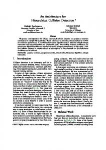
interested parties on the web which are not common specifications of the traditional database architectures where the architecture is built on user access, efficiency, consistency and analytical capability. As BCDB can store, manage and manipulate any kind of data, it is particularly useful for asset transaction under authority of multiple parties within a common decision base. The following are some of the specifications of BCDB relevant with cadastre data surveying and recording. - Transactions for an asset are created by none/one or many participants in the BCDB. - The types of transactions are ‘create’ and ‘transfer’. - ‘Deletion’ is generally not applicable in BCDB transactions. - The assets are attributed and defined as non-dissolved, non-divisible as well as divisible. - Transactions of an asset could be performed by mutual policy defined by the owners. - The authorization could consist cryptographically sign due to asset definition. - The transaction is verified as the conditions are satisfied due to definition of the asset. - Any double-transaction is prevented. - All the information related with an asset in a timeline and time trace are all preserved in the registry. 3.3. The Data and Methods 3.3.1. Introducing the Data and Problem: Boundary Dispute, Two Physical Boundaries The ‘Base Cadastre’ due to Law#3402, had been conducted in Kırşehir in 2004, after first cadastral surveys in 1982. The surveys in 2004 updating process comprises digitization of old cadastre maps, datum transformation and re-measuring the physical boundaries as well as staking the existing boundary out the field, if the boundary has no physical reference. Starting from 2016, cadastral surveys so called ‘Updating Cadastre due to Law #3402 Item 22-A’ planned for execution. The parcels xxxx/4 (The parcel numbers are not given by intention) and xxxx/5 have a common physical boundary – a stone wall- and a shared graphic representation in the cadastre data during base cadastre campaign conducted in 1982, (Figure 1.a and Figure 1.b). This boundary has been approved by the landowners at both sides of the bounding edge, namely xxxx/4 and xxxx/5. When the landowner of xxxx/5 passed away, the property sold to third party whom asked a certified surveyor to stake-out his land’s boundary. The concrete-metal fence has been built after the newly field measurement. The distance between two boundaries is 60 cm’s. The change in boundary with 60 cm, cause a difference of 21 m2 for the parcel for a total area of 525 m2, where the error limit (clearance) is 9.6 m2 ( = 0.00042 x scale x SQRT (area)), due to error threshold in cadastre applications.
60 cm
Figure 1.a: Parcel Boundary (General Boundary)
Figure 1.b: Gap Between Two Parcel Boundaries
3.3.2. A Use Case: Cadastral Survey for a Boundary In order to prevent dispute cases regarding multiple physical boundaries, the cadastre surveys need to be handled by approval of the participants. To handle such a problem, the rights and approval authorization for data registration and updating are made possible by means of a CAD/GIS data structures which keeps a registry (ledger) of transactions that are shared among multiple partners in a distributed network of computers. This model is called ‘Blockchain’. In the Blockchain framework, the partners can manipulate (add, update, delete) the registry and data in a secure way without the need for a central authority by using authorization right and using cryptography. In Blockchain model, the individuals
Abdulvahit Torun
could be enabled to access and manipulated the data whereas they are authorized along with public institutions (Bal, 2017; Dinh et.al., 2017; English et.al., 2016; Bartosh, 2012). A use case of cadastral survey for a boundary is given in Figure 2, whereas there are four stakeholders on the property. The land registry and cadastre are authoritative and trusted nodes in the use case. The landowners having shared boundaries have approval rights for the transaction. The certified surveyor is not presented here because it has been assumed in cadastre. In the use case, one of the owners start the transaction, as cadastral survey is approved by both owners, the outcome is registered in the land registry book. In case of a dispute, the transaction could not be ended. In case of non-finalized transactions, the data is stored however nothing changes in the state.
Land Regisrtry: R
Owner: A
Cadastre: C
Owner: B
Request for Change CREATE (UpDate) IDA, KEYAC Observation, Determination
Draft Cadastre
Inform request CREATE (UpDate) IDC, KEYCB
ChangeFeed toBeAppoved CREATE (UpDate) IDC, KEYCA
IDC, KEYCB
ChangeFeed Approve/DisApprove CREATE (UpDate)
UpDated Cadastre
Decision
IDA, KEYAC
IDB, KEYBC
IDC, KEYCR UpDated LandRegistry
ChangeFeed Update LandRegistry IDR, KEYRC
IDR, KEYRA
IDR, KEYRB
Figure 2: A Use case for LR and Cadastre data transaction
3.3.3. Methodology: Architecture of Blockchain Cadastre Database and Data Processing There are three components which are loosely coupled, namely ‘blockchain database’, ‘middleware’ and ‘GIS/CAD’, in the proposed geodata enabled blockchain model. In the proposed architecture, there are three main components in a Land Registry and Cadastre (LR&C) Blockchain (BC) Node, given below. Brief explanation about the functionality of the components described below. Land Registry and Cadastre (LR&C) Blockchain Database (LR&C BC Database): This component handles the communication and trace of transactions. The LR&C BC DB is designed in three layers. These layers are - The LR&C BC Application: The application provides an interface for all the users such that the transactions are performed at three levels, namely ‘institutional’, ‘landowner’ and ‘geometry’.
Hierarchical Blockchain Architecture for a Relaxed Hegemony on Cadastre Data Management and Update: A Case Study for Turkey
-
The LR&C BC Transaction Engine Model comprises three sub models namely ‘LR&C BC Engine’, ‘LR&C Data Model’, ‘Community Consensus’ Blockchain Infrastructure: The computational infrastructure of the BC model is based on three levels and communication protocols between the levels, namely Ubuntu as operating system, RethinkDB as DBMS and BigchainDB as BC database instance.
LR&C Transactions Middleware (Python) : This component Synchronizes the 'LR&C BC DB' and 'Temporal GIS/CAD Engine for LR&C Transactions' and Maintains Common Registry (Ledger) and handles a lossless geo and nongeo data transaction. Spatio-temporal GIS/CAD Engine for Land Registry and Cadastre Blockchain Transactions (GIS/CAD Engine for LR&C BC Transactions): This component handles the geometrical part of cadastre survey with two sub components; GIS for management and decision support and CAD for storing and managing high accuracy geo-data.
LAND REGISTRY & CADASTRE (LR&C) BLOCKCHAIN (BC) NODE
LR&C BC Database LR&C BC APPLICATION (Python) LEVEL 1 : Institutional (Region/Block) LEVEL 2: Landowner (s) (Object/Parcel/) LEVEL 3: Geometry (Part/Edge/Node) LR&C BC TRANSACTION ENGINE MODEL (Python) LR&C BC Engine LR&C Data Model Community Consensus BC INFRASTRUCTURE LAYERS BigChain BD ReThinkDB DBMS Ubuntu (+ Relevant Drivers)
Loosly Coupled LR&C BC and GIS/CAD Middleware
LR&C Transactions Middleware (Python) Syncronizes the 'LR&C BC DB' and 'Temporal GIS/CAD Engine for LR&C Transactions' and Maintains Common Registry (Ledger) (Specific to the 'Node LR and C')
Spatio-temporal GIS/CAD Engine for LR&C BC Transactions GIS ENGINE FOR CADASTRE DATA MANAGEMENT (ArcGIS) GIS Data Management, Analysis and Monitoring GIS/CAD Simultaneous Trans. Module Temporal GIS/CAD Integration Module (Simplification&Generalization)
CAD ENGINE FOR CADASTRE DATA MANAGEMENT AND TRANSACTION (ArcGIS) Temporal GIS/GIS Common Data Trans. Module
Figure 3: Architecture for Land Registry and Cadastre (LR&C) Blockchain (BC) Node
In the LR&C BC Database component of blockchain architecture, there are three levels in a hierarchy to control and mutually decide on any transaction by approval of relevant participants in accordance with the land registry and cadastre organization as a trusted node watching the procedures. Each node has to have all components unless the community members decide in another way. For instance, the individual land owners need not to have the GIS/CAD component as a whole, despite other institutions which produce cadastre data such as ‘As is Map/Plan’.
4. Designing and Implementing GIS/CAD Component of Blockchain Architecture for Cadastre The ‘Spatio-temporal GIS/CAD Engine’ has the functionality of ‘GIS Engine for Cadastre Data Management’ and ‘CAD Engine for Cadastre Data Management and Transaction’. The GIS module handles all data management such as
Abdulvahit Torun
approving a cadastre transaction, managing the changes in temporal geospatial databases with linked CAD data, booking and watching time traces of assets among others. The CAD module is responsible for performing the geometric part of the transaction unless the GIS module approves. Implementation of the cadastre transaction in a geo-data structure and a geodatabase in blockchain environment are presented in Figure 4. The realization of the physical model is accomplished in ESRI ArcGIS programming environment. The communication between the GIS/CAD module and the other components are handled by using tokens and triggers.
4.1. Designing a Geodata Transaction in Spatio-Temporal GIS/CAD Engine: Geodata Transaction at Data Set (Database) Level in Blockchain The blockchain database transaction at data class (a data class consists of same kind of data (features)) level in a geodatabase is handled as depicted in Figure 4. The geo-transaction is handled as follows; At epoch ti , the geometries of two parcels are at stable state. - As, the landowner ‘A’ of parcel ‘N1’ at node ‘Nm’ require an update, the draft geometries of the parcels are stored in a temporal data class where relevant data is prepared to update the parcels in case of approval by all parties. The parcel ‘N1’ is extended and kept in a separate data class so as the shrinking parcel ‘N2’, whereas these parcels are labeled as ‘#N1’ and ‘#N2’ respectively. - As all the relevant parties approves the transaction, the new state of the parcels are replaced with the old one in the current data class. In parallel process, the parcels at previous stage and the data created at update level are all stored in the ‘Data Class (Historical Trace)’.
Asset (Parcel-ID, Owner, Spec’s) ti
Data Class (Running) Before Transaction
Asset(N2, B, SB)
t#
Asset(N1, A, SA)
Data Class (Temporal#) Data Class (Historical Trace)
tj
Asset(#N1, #A, #SA) + -
Asset(#N12, : #A B , SAB)
t#
Asset(#N2, #B, SB) Asset(N2', B', S'B) Data Class (Running) After Transaction
Asset(N1', A', S'A) Figure 4. GIS/CAD Data Classes in BC Geo-Database to support geometric data transaction
4.2. Process-Flow of Blockchain Cadastre (Editing)Transaction System – BCCTS Figure 5 depicts the process flow and data flow in the implemented BC Cadastre (Editing) Transaction System. Any user interacts with the BC Cadastre Transaction System (BCCTS) via the same interface by means of ‘KEY’ and ‘ID’. The users are only allowed to start/request a transaction, access the data or any other given privileges through the ‘Current Data’. Started transactions are maintained in ‘Temporal Data’ until all relevant parties perform their role and approve the transaction within a given time period or given conditions. Another transaction cannot be started for the same entity, unless the current one is finalized or the transaction is dropped due to a rule of ‘BC Community’. In any case; either successfully finalized or dropped, all data is transferred into the ‘Archive Data’ to be stored. In the prototype, the temporal and archive data are stored in the same physical repository. Eventually, all data in archive is linked to the property that is currently in use. Any data in the ‘Archive Data’ is bound to a transaction by means of transaction ID which uniquely
Hierarchical Blockchain Architecture for a Relaxed Hegemony on Cadastre Data Management and Update: A Case Study for Turkey
identifies participants, time track as well as all the previous and next state of the entity. Besides, the BC GeoDatabase maintains all text and geodata during the process of interaction. The geometries are stored as in GeoJSON format with a link to the database. As any user requests a previous geometry, the GeoJSON data is converted into a feature that ArcGIS can process by using the library of NewtonSoft.JSON.
Current Data (Cadastre_RealTime) Users:
Interface:
Land registry
Trusted User
Cadastre
User
LandOwner
(Blockchain Node)
User (i)
Temporal Data (Transaction_ToBeAprroved)
Geometry: GeoJSON .NET JSON Archive Data (LinkData_TimeTrack)
Figure 5: Blockchain Cadastre (Editing)Transaction System – BCCTS
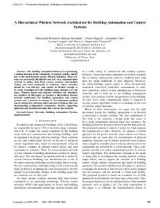
4.3. Implementing Geodata Transaction in BC Spatio-Temporal GIS Engine In Figure 6, the request for geometry change (boundary change) by a user and the proposed new geometry along with the previous old geometries are accessible by relevant users for approval. As all the parties approve the transaction, the approved geometry is transferred into the current data. In Figure 6, the red boundary represents the neighboring parcel, whereas the black boundary is the initial state of the parcel subject to transaction. The green (selected) polygon is one of the proposed change where the hatched green polygon with vertices is the second proposal for change. Both proposals are maintained in the dataset. As the trusted authority approves one of the proposals, the transaction is set and the new state of the parcel replaces the current state (black boundary). The current state, the proposals and any other geometry changes are all moved to the ‘archive dataset’.
Figure 6: The Transaction Process for Approval
4.4. The Technology Used for Implementation
Abdulvahit Torun
The prototype BC geo database has been developed on ESRI ArcGIS by using C# and libraries of ArcObjects COM components. The ESRI ArcObjects SDK for .NET has been used to code this application. ArcGIS GeoDatabase is designed to support the integrity conditions defined in the use case. As the scope of this paper is, developing a prototype to perform geodata transaction to prevent boundary errors, the non-relevant cadastre information is not modeled in the geodatabase. The interface is realized as an ArcGIS toolbox. The state of an entity, information about transactions are stored in JSON, the temporal and archived geometries are stored in GeoJSON and current state of the geometries are stored in physical data set. Although this model seems a bit complex, this approach enables the system to maintain nonatomic, multi-level, multi-characteristics data as a manageable package. The conversion of attribute values in the ArcGIS geodatabase into JSON, the open source DLL, NewtonSoft.JSON is used. The NewtonSoft.JSON serializer converts types of .NET and types of JSON, in between.
5. Evaluation and Conclusions 5.1. Evaluation Evaluation from Economical and Legislative Point of View The cost of at base cadastre campaign and cadastre updating survey are USD 34.0 and USD 12.0. Cost of a stake-out survey by certified surveyor is about USD 200-250 USD and cost of a court case which takes about three years is about 3000 USD, if the court is not busy and stocked with court cases. These costs have been given, how the cost of determining boundary of a parcel, unless the cadastre surveys are conducted with qualified teams, with all relevant partners among others. Nevertheless, technical personnel of the local cadastre organizations are very much engaged in the requirements of expertise from the cadastre courts to conduct field work or submit technical report. Although the initial costs are very low, the succeeding costs for re-measurement by a certified surveyor is about 8 times more, eventually the cost of a court case is about 100 times costly in case there exist a kind of dispute caused by low quality cadastral survey. Based on the legislation in the Turkish Civil Code which reads as ‘booking and maintaining register is under guarantee of the State’, the courts including the Constitutional Court, consider the land registry and cadastre as separate tasks and any mistakes in cadastre survey is not under responsibility of the State. The courts assume the land owners to have to know the area and boundary during transactions. In this respect, courts and Constitutional Court evaluated and made decisions about the cases that argue the responsibility of the State for cadastre surveys. Evaluation from the Point of Cadastre Survey and Cadastre System There are two physical boundaries in the field although there is unique in cadastre data, in the given case study. The physical boundary demarked with the stone wall is due to the cadastre works in 1982, on the other hand, the boundary demarked with metal fence is result of a stake out survey based on 2004 cadastre survey. This situation, indeed, can be extended through all parcels in the neighborhood and most probably in the whole town. Besides the technical, legal problems of Turkish Cadastre including the initialization started by unnecessarily detailed Law # 3402 and over-integration of Cadastre and Land registry under the same roof despite other examples of cadastre organizations from German tradition. There are several reasons of the case studied in this paper. Main causes of this occasion are; these are The efficiency considerations in the ‘base cadastre survey campaign’, the quality of cadastre processes, the over tightly integrated structure of the cadastre organization, the unnecessarily detailed and over-intervening characteristic into cadastre survey and implementations of the Law # 3402. Evaluation from the Point of Modern User Requirements There is increasing demand for precise cadastre data for many purposes including smart cities, digitalization of urban management, autonomous car navigation among others. The data created in first ‘Base Cadastre Data’ for planning, land development, urbanization, farming among others as well the ‘New Base Cadastre Data’ have already been used by many institutions, individuals Thus there is a dual, triple existence of data such that; ‘the base cadastre data’, ‘the update’ and ‘the date created by other institutions for a particular project’. In the ‘digitalization’ era, the user of cadastral data are machines but not human; such as ‘navigation engine in a car’. In this environment of the ‘to-be-digitalized World’, the owners of data are no more centralized, data from multiple sources has to be reconciled for accurate decision making where a new data sharing, de-centralized data approving, quality assurance and data delivery model and mechanism needed. Besides, democratization and decentralization of spatial data among multiple institutes and even individuals compel the Global Cadastre Community to search, find and realize new approaches where ‘data owner is the king’.
Hierarchical Blockchain Architecture for a Relaxed Hegemony on Cadastre Data Management and Update: A Case Study for Turkey
5.2. Conclusions In this paper, we have introduced a case study of two physical boundaries belonging to an identical cadastre boundary data. This particular dispute case could only be resolved in a cadastre court after one of the landowners claim for unification of the physical boundary. Meantime, we have given the cost of a parcel survey at base cadastre survey campaign, in the updating process, a survey service provided by a certified surveyor and an average cost of a court case, to give the reader how the cost exponentially increases, unless a careful cadastre process implemented. Finally, we have proposed a system designed on blockchain technology to prevent mistakes in cadastre survey and booking pahases where the landowners are participating as an equal partner in the cadastre survey and decision making process. The ‘GIS Engine for Cadastre Data Management’ part of the ‘Spatio-temporal GIS/CAD Engine’ component of Land Registry & Cadastre (LR&C) Blockchain (BC) Node is designed and implemented. The GIS module handles all aspects of geometry of cadastral parcel and survey and data management such as approving a cadastre transaction, managing the changes in temporal geospatial databases with linked CAD data, booking and watching time traces of assets among others. This study gives design and the implementation of ‘the GIS part’ of the component based on a given use-case which manages the geometry part of the BC transaction in the systems. In this respect the following has been designed and implemented; - Architecture of the Node of Blockchain Cadastre Database (BCCD) and Data Processing having three components namely ‘blockchain database’, ‘middleware’ and ‘GIS/CAD’, is designed and the ‘GIS/CAD’ component is realized. - The design and implementation of process flow and data flow are accomplished of the BC Cadastre (Editing) Transaction System. - The realization of the physical model of BC geo database is accomplished by using C# and ESRI ArcObjects SDK for .NET and libraries of ArcObjects COM components. - An open library of NewtonSoft.JSON is used for converting non-atomic attributes of text and geodata between .NET and JSON) GeoJSON. This study is pioneering to use blockchain technology to minimize the surveying problems caused by incautious considerations and application of cadastral regulations at surveying and data manipulation phases where the landowners are regarded as equity partners in mutual decision making. In the proposed framework, the current authority and hegemony of the organization for cadastre and land registry is considerably limited for the sake of landowners. In this respect, although the time/money efficiency of cadastral survey may decline considerably, the quality of the cadastre data and appreciation of landowners be increased by avoiding costs of court cases. The international surveying society-FIG, UN-GGIM, World Bank and international branches of national cadastre and land registry organizations have been helping developing and low-developed countries of which land administration is non existing at a rate of 70% for decades. The aid from the developed countries, societies and international organizations have been appreciation, though they might not goal the real problems due to lack of knowledge on cultural, traditional, historical, legislative, socio-economic issues. Despite great efforts from the international societies towards the developing countries, the goals are not easily accomplished. The case study in this paper is a clear example of problem characteristics in a developing country, Turkey where huge investments has been oriented for better cadastre and better land management in the era of digitalization and smart countries. Eventually, a ‘Hierarchical Blockchain Architecture for a Relaxed Hegemony on Cadastre Data Management’ is presented that aims at both solving a particular problem of multiple physical boundaries for an identical cadastral boundary data and for providing an approach to introduce the land owners into the core of cadastral decision making in the environment of open-data-policy, decentralization and democratization of geospatial data
Acknowledgements The test software has been developed in cooperation with T.K.
REFERENCES Bal, M. (2017), Securing Property Rights in India through Distributed Ledger Technology, ORF Occasional Paper # 105 January 2017 Bartosh, C.D. (2012), Integrating Land Survey Data into Measurement-Based GIS: An Assessment of Challenges and Practical Solutions for Surveyors in Texas, MSc. Thesis, Faculty of The USC Graduate School University of Southern California Cete, M. (2014), An Analysis of the Turkish Cadastre in View of the Cadastre 2014 Vision, FIG Working Week 2015, Sofia, Bulgaria, 17-21 May 2015 Chachkhunashvili, S. (2016), Using Blockchain Technology for Land Registration - National Agency of Public Registry NAPR, Georgia, Report of Joint Conference EuroGeographics-CLRKEN, PCC, EULIS, Bratislava, 2016 Demir,O., B. Uzun and M. Çete (2008), Turkish Cadastral System, Survey Review, 40, 307 pp.54-66 (January 2008)
Abdulvahit Torun
Dijkstra, P., C Lemmen, A De-Boer, E M Unger (2015), Surveying the Future: Mapping the Bitcoins, FIG Working Week, Young Surveyors Session. file:///C:/Users/Administrator/Downloads/FIGWW2015_ys_dijkstra_lemmen_deboer_unger_bitcoins.pdf Dinh, T.T.A. , R. Liu, M. Zhang, G. Chen, B.C.Ooi, J. Wang (2017), Untangling Blockchain: A Data Processing View of Blockchain Systems, arXiv:1708.05665 [cs.DB] English, M.S. Auer, J. Domingue (2016), Block Chain Technologies & The Semantic Web: A Framework for Symbiotic Development, http://cscubs.cs.uni-bonn.de/2016/proceedings/paper-10.pdf, Accessed Sept_09 2017 Fetai, B. (2015), Analysing the Effects of Merging Land registration and Cadastre, MSc Thesis, the Faculty of Geo-Information and Earth Observation of the University of Twente, March 2015, Enschede, the Netherlands, FIG
(2017), CADASTRE 2014 and Beyond, FIG Publication http://www.fig.net/resources/publications/figpub/pub61/Figpub61.pdf, Accessed Sept_09 2017, Accessed Sept_09 2017
No:61,
GIM (2007), Registry and Cadastre Under One Roof, Turkish Cadastral Organisation, GIM International, https://www.giminternational.com/content/article/turkish-cadastral-organisation, Accessed Sept_09 2017 Gundelsweileri, G., T. Bartoschek, L.A.C. Marques de Sá (2007), Development in The German Cadastre, Bol. Ciênc. Geod., sec. Comunicações, Curitiba, v. 13, no 2, p.423-432, jul-dez, 2007. Gruber, U., J. Riecken, M. Seifert (2014), Germany on the Way to 3D-Cadastre, 139. Jg. 4/2014 zfv, DOI 10.12902/zfv-0028-2014, Fachbeitrag ISO 19152 (2012), Geographic information — Land Administration Domain Model (LADM), International Standard, First Edition, 2012-12-01 Jones, B., N. Land (2012), Cadastre 2.0 – A technology vision for the cadastre of the future, FIG Working Week 2012, Rome, Italy, 6-10 May 2012 Kaya, S. (2003), Dünya Bankası ve Dünya Bankası Kredilerinin Denetimi, Sayıştay Başkanlığı, Araştırma Raporu Lantmateriet-Sweden (2016), The Land Registry in the blockchain: A development project with Lantmäteriet (The Swedish Mapping, cadastre and land registration authority), Telia Company, ChromaWay and Kairos Future, July 2016, Louwman, W. (2017), Advantages and Disadvantages of a Merger Organization: The Case of the Kadaster-Netherlands, 2017 World Bank Conference on Land and Poverty”, The World Bank - Washington DC, March 20-24, 2017 Sarı, N.İ (2017), 22/a Uygulamasi Nedir? Ne Değildir? Sorunlar Ve Çözüm Önerileri, İzmir Kadastro Md.lüğü, http://www.izmirkadastro.gov.tr/User_Files/dokumanlar/22a_uygulamasi_sorunlari.pdf TKGM (1987), 3402 Sayılı Kadastro Kanunu TKGM (2008), Turkey Land Registration and Cadastre Modernization Project (P106284), The World Bank TKGM (2016), Additional Financing for Land Registry and Cadastre Modernization Project, World Bank Loan Agreement No 8541TR, http://documents.worldbank.org/curated/en/990601500026396525/pdf/TU-85410-AF-Land-Registry-and-Cadastre-2016Audit-report.pdf, Accessed Sept_09 2017 TKGM (2017_1), Tesis Kadastrosunun Bitirilmesi Projesi, https://www.tkgm.gov.tr/tr/icerik/tesis-kadastrosunun-bitirilmesi-projesi , Accessed Sept_09 2017 TKGM (2017_2), MEGSIS Performans Çizelgesi, https://cbs.tkgm.gov.tr/istatistik.aspx, Accessed Sept_09 2017 Toker, N.K (2016), Kadastro Mevzuatı, 2016, Tapu ve Kadastro Genel Müdürlüğü, Kadastro Dairesi Başkanlığı Reference: UNDESA (2017), World Population Prospects,The 2017 Revision, Key Findings and Advance Tables, Department of Economic and Social Affairs Population Division, Report ESA/P/WP/248, Newyork 2017 Yaşayan A., H. Erkan, S. G Seylam (2011), Kadastro Kavramı 13. Türkiye Harita Bilimsel ve Teknik Kurultayı, Nisan 2011, Ankara
ve
Türkiye
Kadastrosu,
TMMOB HKMO
Vos, J. (2016), Blockchain-Based Land Registry: Panacea, Illusion or Something in Between? Legal interference of Registrars in the e -conveyancing process, 7th Publication, European Land Registry Association (ELRA)