International Conference on Remote Sensing, Environment and Transportation Engineering (RSETE 2013)
Development method of simulation software of landscape affecting traffic safety in traffic system d
Yang Zhifaa, Guan Xingb
[email protected]
State Key Laboratory of Automobile Dynamic Simulation, Jilin University
Yu Zhuo3*, c,
Changchun, Jilin 130022, P.R.China;
3 Basic Sciences College of ChangChun University of
a
b
[email protected],
[email protected]
Technology Changchun, Jilin, P.R.China, ST:130012
a
Yang Zhifa , Li Shiwu
d
c
Traffic and Transportation College, Jilin University
[email protected],
* Corresponding author
Changchun, Jilin 130022, P.R.China; one is highway scene simulation which focus on the coordination of road and landscape, typical results are LADS DS which is from university of Leeds of UK [4], SmartPath which is from university of California of USA [5]; the other is the research results which achieve simulation capabilities of part of the traffic system, such as IHSDM system for highway alignment design [6], HYSIM for researching person's psychological and behavioral [7]. According the method of literature [8], the developing flow of simulation software of landscape affect traffic safety will be researched, and then the result will be achieved by operating the software. This work will provide effective means to research landscape affect traffic safety.
Abstract — Simulation is a resonable method to research the impact of landscape on traffic safety. In this paper, two different charts of main control program of the simulation program and chart of main simulation program are researched; the simulation program was built by Visual Basic and Access Database. The impact of vehicle speed, radius of curved road and landscape position on the risk probability of the road were analyzed by simulation. The results showed: when radius of curved road are same, the risk probability of the road with high road design speed was smaller than that of low one, for example it was reduced about 41.7% when the road design speed is 80km/h than that is 60km/h; the risk probability of the road reduced about 58% at large radius curved road than small one when the landscape is in the same place and road design speed does not change.
II. DEVELOPMENT METHODS
Key words—Road safety, landscape, traffic safety, simulation software, development process
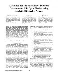
A. Software Development Process 1). Flow chart of main control program. For acquire simulation results of different road environment, vehicle speed and landscape position were set as loop variable. The flow chart of main control program is shown in Fig.1. 2). Flow chart of main program. The basic idea of the simulation of the main program is as following: in one loop, by using the parameter, the standard sight distance (shorted by SSD) will be set and the driver sight distance (shorted by DSD) will be calculated through the model [8], and then safety status of vehicle will be judged by comparing SSD and DSD. The number of vehicle run on the simulation road is the loop number, each time the safety status will be judged, the accident number will be recorded, and the probability of risk will be calculated by main control program after the simulating vehicle operated many times. The probability is the safety status of this road in a certain period. The flow chart of main program is as shown in Fig.2.
I. INTRODUCTION Road landscape affects traffic safety by many ways, so research work on it would be restricted. The simulation technology for traffic system can make the scene, vehicle operation or accident reappear, and can avoid the risk of the experiment which real vehicle, so simulation is the best method to research the impact of road landscape on traffic safety. The simulation technology for traffic system (STTS) was developed with the development of computer technology from 1960’s, it is a flexible experimental platform where road and traffic design combine together very good. According the describing levels of detail, STTS can be divided three types: macro-simulation, meso-simulation and micro-simulation [1]. According the difference of functions, STTS can be divided the following three types, one is driving simulator (DS) which focused on the automotive performance evaluation, typical results are the driving simulators of auto manufacturers and research department in Europe, America and Japan [2], ADSL DS of Jilin University of China belongs to this type too [3];
© 2013. The authors - Published by Atlantis Press
558
simulation model parameters enter module, they are vehicle model, driver model, landscape model and road model, they must be set a value according the requirement of simulation; in the second, driver sight distance calculation module will be started, the DSD will be calculated, the SSD will be set; third, program controlling module will be started, after set the loop times, the program will run, and the result will be outputted; at last, the probability tendency chart of risk status module will be activated when program controlling module start, the probability tendency chart of risk status of the road will be outputted.
B. Simulation software development According the idea of the flow chart of program design, the simulation software of landscape affecting traffic safety was developed by Visual Basic and Access Database [8]. The simulation software was made of five modules; they are simulation model parameters entering module, driver sight distance calculation module, program controlling module, probability tendency chart of risk status module, and result outputting module. The basic operation flow of this program is as following: at first, there are four simulation models in
Beginning of the simulation
B s
Inputting the simulation model’s parameters
I ’
s p
Seting the ceiling of loop variable (V0,WZ0)
yes
S o
Judge vehicle speed (v), if v>V0 ? y
no yes
e
J
u
(
Judge the position of landscape (wz), If wz>WZ0 ?
n y
e
J i
no
0
n
Call the main program
C p
wz=wz+step1 v
v=v+step2 wz=0
w v
Outputting the simulation results
O r
End
E Fig.1. Two difference main controlling program flow chart
559
Setting loop times(k0)
model parameters initialization
Loop counter k, If k>k0 ?
yes
no Judging if the transverse slide accident occur?
yes
Generating vice-vehicle (a vehicle or obstacle which is in front of host-vehicle)
no
no
no
Passing over SD(Dh)
Stopping SD (Dt)
Acquiring speed of host-vehicle (Vz)
Calculate driver SD (SDj)
Setting standard sight distance(SD)
Acquiring speed of vice-vehicle (Vf)
Calculating △V=Vz-Vf
Judging the relation of △V and Vz Calculate difference of SD
△SDt=SDj-Dt △SDh=SDj-Dh
△V>Vz
△V=Vz
△SDh>0
△SDt>0
△V