DATA ACQUISITION AND MODELLING (MONITORING, PROCESSES, TECHNOLOGIES, MODELS)
EO-based landslide mapping: from methodological developments to automated web-based information delivery Daniel Hölbling1; Clemens Eisank2; Barbara Friedl1; Elisabeth Weinke1; Hannes Kleindienst2; Arben Kociu3; Filippo Vecchiotti3; Florian Albrecht1 INTRODUCTION Landslides are recurrent natural hazards in almost all mountainous regions of the Earth, claiming people‘s lives and destroying man-made infrastructures. Detailed, accurate and complete digital landslide inventories are still rarely produced, although such maps are essential for supporting emergency services and authorities after landslide-triggering events, as well as for hazard and risk assessment. Promoted by the increased availability and quality of Earth Observation (EO) data, attempts to automate the production of landslide maps have recently been undertaken. As demonstrated by several case studies, especially object-based image analysis (OBIA) provides methodologies that are valuable for automated landslide mapping. METHODS Within the project Land@Slide (full project title: EO-based landslide mapping: from methodological developments to automated web-based information delivery; 03/2015-08/2017), funded by the Austrian Research Promotion Agency (FFG) under the Austrian Space Application Programme (ASAP 11) programme (contract no: 847970) the overall objective is to implement a pre-operational service for EO-based landslide mapping with focus on high resolution (HR) and very high resolution (VHR) optical satellite images. A major challenge is to develop OBIA mapping routines that are automated and ideally flexible to changing input data and geographical settings, and hence, generally applicable. The most stable routines are identified and integrated in a pre-operational web-based service, which allows for automated EO-based landslide mapping as well as the identification of landslide affected infrastructure (e.g. roads, railway tracks). A crucial step is to design the service close to the requirements of potential users and decision 102 | INTERPRAEVENT 2016 – Extended Abstracts
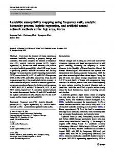
makers, e.g. the Austrian Service for Torrent and Avalanche Control, the Austrian Federal Warning Centre, the Austrian Federal Forestry Office, regional geological and surveying agencies. Thus, semi-structured interviews have been conducted with several local/regional stakeholders and decision makers. Their expectations on EO-based landslide mapping products and services are considered for the conceptualisation and implementation of the landslide web service. Figure 1 illustrates the service architecture. It shows the software packages and tools to be used, the processes, the data formats, as well as the expected products. The workflow indicates all the steps towards providing landslide information for serving the user needs. Pre-processed EO-data and other geospatial data are accessible via a web portal, which also allows the selection of test areas and downloading the results in a preferred data format. A data catalogue structures and manages servicerelevant input and output data in different formats. Metadata are compiled following international standards (e.g. ISO 19115-1 ‚ Geographic Information - Metadata‘ from ISO/TC 211). Embedded geoprocessing components of the service architecture are the object-based routines for landslide mapping on one side, and spatial analysis algorithms for the detection of affected infrastructure on the other side. For web processing and service-based data publishing standards of the Open Geospatial Consortium are followed. For testing the service several landslide-affected study areas with different environmental characteristics have been pre-defined in Austria and South Tyrol, Italy. Various HR and VHR optical EO data sets (e.g. Landsat, SPOT, WorldView-2/3) are used, including also very recent satellite data from Sentinel-2. A comprehensive analysis of the suitability of different optical data for mapping landIP_2016_EA167
slides in distinct geographical areas will be conducted and the most robust and reliable landslide mapping routines will be implemented in the proposed web-based service. RESULTS AND CONCLUSION All products, i.e. landslide maps depicting the landslides as polygonal structures, mapping routines, and the web service, will be thoroughly evaluated. The spatial and thematic accuracy of landslide maps will be quantified. The usability and relevance of the service will be validated by users and experts. This paper presents outcomes of the
evaluation of the user needs, first mapping results, as well as the preliminary version of the proposed web-based landslide mapping service. For decision makers and practitioners it is essential to know the location, spatial extent, and distribution of triggered landslides. The proposed service is expected to facilitate the monitoring of active landslides and updating of landslide inventory maps, as well as the assessment of landslide affected infrastructure. Moreover, the results may be useful for subsequent landslide risk assessment and susceptibility mapping.
Figure 1. Overview of the landslide mapping service architecture
KEYWORDS Landslides; Remote Sensing; Object-Based Image Analysis (OBIA); Web Service; Geographic Information System (GIS) 1 Department of Geoinformatics - Z_GIS, University of Salzburg, AUSTRIA,
[email protected] 2 GRID-IT - Gesellschaft für angewandte Geoinformatik mbH, AUSTRIA 3 Geological Survey of Austria (GBA) INTERPRAEVENT 2016 – Extended Abstracts | 103