Int. J. Sensor Networks, Vol. 10, No. 3, 2011
111
Landslide monitoring with sensor networks: experiences and lessons learnt from a real-world deployment Alberto Rosi* Dipartimento di Scienze e Metodi dell’Ingegneria, Università di Modena e Reggio Emilia, Reggio Emilia, Italy Email:
[email protected] *Corresponding author
Matteo Berti Dipartimento di Scienze della Terra, Università di Bologna, Bologna, Italy Email:
[email protected]
Nicola Bicocchi and Gabriella Castelli Dipartimento di Scienze e Metodi dell’Ingegneria, Università di Modena e Reggio Emilia, Reggio Emilia, Italy Email:
[email protected] Email:
[email protected]
Alessandro Corsini Dipartimento di Scienze della Terra, Università di Modena e Reggio Emilia, Modena, Italy Email:
[email protected]
Marco Mamei and Franco Zambonelli Dipartimento di Scienze e Metodi dell’Ingegneria, Università di Modena e Reggio Emilia, Reggio Emilia, Italy Email:
[email protected] Email:
[email protected] Abstract: Wireless sensor networks have the potentials to be a very useful technology for finegrained monitoring in remote and hostile environments. This paper reports on the implementation and deployment of a system for landslide monitoring in the Northern Italy Apennines and analyses the positive results we have achieved with it. Yet, the paper also critically analyses the problems and the inherent limitations/difficulties we had to face in developing and deploying such a system, challenging many of the ‘big claims’ that are often heard around wireless sensor networks. Keywords: wireless sensor networks; landslide monitoring; experience report. Reference to this paper should be made as follows: Rosi, A., Berti, M., Bicocchi, N., Castelli, G., Corsini, A., Mamei, M. and Zambonelli, F. (2011) ‘Landslide monitoring with sensor networks: experiences and lessons learnt from a real-world deployment’, Int. J. Sensor Networks, Vol. 10, No. 3, pp.111–122. Biographical notes: Alberto Rosi is a Contract Researcher at the Unimore Agent Group. He received the Laurea degree in Business Management from the University of Modena and Reggio Emilia in 2006. He received PhD in Computer Science from the same university in 2010, with a thesis on Advanced Applications and Services for Pervasive Computing Scenarios. His current research interests include pervasive computing, context-awareness and sensor networks.
Copyright © 2011 Inderscience Enterprises Ltd.
112
A. Rosi et al. Matteo Berti is an Assistant Professor of Soil Mechanics and Slope Stability at the University of Bologna. His fields of activities include real-time monitoring of landslide phenomena, analysis of landslide triggering and evolution, mechanical characterisation of heterogeneous geological media. He has leaded the National Research Program WISELAND (2007-09) on the use of wireless sensor network for landslide monitoring. Nicola Bicocchi is a Postdoctoral Fellow in Computer Science at the University of Modena and Reggio Emilia. He received the Laurea degree in Computer Engineering from the University of Modena and Reggio Emilia in 2004 and PhD in Computer Science from the same university in 2009, with a thesis on Self-organizing Data Ecologies for Pervasive Computing Scenarios. His current research interests include pervasive computing, affective computing, data mining and analysis for behavioural prediction and network security. Gabriella Castelli is a Postdoctoral Researcher at the University of Modena and Reggio Emilia. She received PhD in Computer Science from the same university in 2010, with a thesis on Models and Tools for Contextual Knowledge Management in Pervasive Computing. Her research interests include context-awareness, location-based applications and middleware for pervasive computing. Alessandro Corsini, MSc and PhD in Geology, is a Senior Researcher and Lecturer in Applied Geology at the Department of Earth Sciences, University of Modena and Reggio Emilia. His main field of expertise is on landslide hazard and risk analysis and monitoring. Marco Mamei is an Assistant Professor in Computer Science at the University of Modena and Reggio Emilia, since September 2004. He received the Laurea degree in Computer Engineering from the University of Modena and Reggio Emilia, in February 2001 and PhD in Computer Science from the same university in April 2004, with a thesis on Field-based Coordination in Dynamic Pervasive Networks. His current research interests include applications and infrastructures for pervasive and mobile computing, data mining for location-aware computing. Franco Zambonelli is a Full Professor in Computer Science at the University of Modena and Reggio Emilia since 2010. He obtained the Laurea degree in Electronic Engineering in 1992 and PhD in Computer Science in 1997, both from the University of Bologna. His current research interests include distributed and pervasive computing, autonomic computing and communication, and software engineering for large-scale agent systems.
1
Introduction
Wireless Sensor Networks (WSNs) are attracting an increasing interest due to their potentials for applicability in a variety of scenarios (Estrin et al., 2002; Chong et al., 2003). In particular, sensor networks appear as a powerful tool for monitoring physical and natural phenomena in hostile and remote environments such as remote glaciers (Martinez et al., 2004), active volcanoes (Werner-Allen et al., 2006; Xu et al., 2009) and active landslides (Sheth et al., 2007; Cho et al., 2008; Ohbayashi et al., 2008), as confirmed by the increasing number of real-world deployments of sensor network systems. From our side, a multi-disciplinary cooperation among the Pervasive Computing group and the Applied Geology group of the University of Modena and Reggio Emilia (together with the Applied Geology group of the University of Bologna and the Department for Environmental Protection of the Regione Emilia Romagna) has led to the design, development and deployment of a prototype sensor network infrastructure for landslide monitoring in the Emilia Romagna Apennines. The infrastructure is designed to provide a fine-grained measurement of environmental parameters and landslide accelerations, and it aims at demonstrating the potential of such a technology for landslide monitoring. In this context, the contribution of this paper is twofold. First, we describe the implemented monitoring infrastructure and present the preliminary, yet encouraging, results we have
obtained from it. In particular, we show that sensor networks have the potential to effectively complement more traditional sensing infrastructures in landslide applications, making onfield monitoring easier and more affordable. Second, we critically analyse the several challenges and technical problems we had to face in the process of developing and deploying the infrastructure, and the improvements needed to make it practically usable and useful. Most of the lessons we learnt in this process are of a general nature, or at least we believe so. In a word, by working in the field, in a remote and hostile environment, we have found that many of the scholarly known advantages of sensor network technologies (e.g. no need of infrastructure, no need of careful network layout planning, self-configuration of communication paths and resilience to faults in sensors) can be only partially exploited, and at notable costs. The remainder of the paper is organised as follows. In Section 2, we describe current technologies for landslide monitoring and introduce the potential advantages in deploying a WSN as a standalone monitoring tool or in conjunction with external instruments. In Section 3, we present the sensor network infrastructure we deployed at Calita, a village, in the Reggio Emilia Province, characterised by widespread slope instability phenomena. In Section 4, we discuss the lessons we learnt during the implementation of our system. Section 5 describes the related work in the area. Section 6 concludes and identifies areas for future research.
Landslide monitoring with sensor networks
2
Landslide monitoring with WSNs
A landslide is a movement of a mass of rock, debris or earth down a slope (Highland and USGS, 2004). Gravity is the primary reason for a landslide, but many other factors can affect slope stability, either natural (weak materials, weathering, river erosion, rapid snowmelt and intense rainfall) or human-driven (excavations, deforestation, mining and artificial vibration). Continuous and reliable field monitoring, eventually associated with early warning systems, are essential tools for hazard assessment and landslide risk management (Rosenberg, 2007). Monitoring methods are exploited to measure the relevant parameters for slope stability, such as ground displacements (surface and subsurface displacement, elevation changes and cracks opening), groundwater conditions (depth of the water table, pore water pressure, suction and soil moisture), surface water conditions (runoff discharge and water chemistry) and climatic parameters (rainfall, snowfall and temperature). The knowledge of spatial and temporal distribution of these factors is of fundamental importance for the understanding of landslide dynamics and for the management of the associated hazard.
113 several characteristics of WSNs can make them suitable and highly competitive for landslide monitoring both if deployed as a monitoring tool per se or in conjunction with external instruments (ground-based and/or aerial). These characteristics include: 1
A sensor network can collect, aggregate and analyse from a multi-point perspective diverse and distributed data. The availability of distributed data can improve the general understanding of landslide dynamics and can enable the detection of patterns that would be otherwise very hard to identify. In the case of landslides, particular patterns of relevant parameters (e.g. pore water pressure or slope displacements) could indicate the approaching of critical conditions of the slope.
2
Sensor networks could (at least in theory) be deployed without requiring any pre-existing infrastructure and very quickly. For landslides, this means the capability of setting up an emergency monitoring system in a short time, which is a crucial point when dealing with potentially dangerous phenomena.
3
Sensor networks, by exploiting multi-hop communications, can be distributed also on wide areas at limited wiring costs. For landslides, which can extend over several square kilometres, this is a very important feature.
4
Energy-efficient algorithms for sensor network have been developed allowing the network to run for months without human intervention at nearly no costs. For many landslides, which are characterised by long period of quiescence and then suddenly reactivate, this is a very important feature to ensure continuous, long-term, yet low-cost, monitoring.
5
Wireless communications avoid physical wiring between sensors and data loggers. This feature is relevant for landslides since they are typically found in difficult-to-bereached and uncomfortable environments such as sharp mountains and slopes. Moreover, electrical wires could be damaged by animals and slope movements.
6
WSNs can be integrated to existing instruments, acting as an infrastructure to collect, process and transmit their data to a remote base station, and thus helping alleviating the identified limitations of existing ground-based techniques.
3
The Calita infrastructure
2.1 Current technologies and their limitations A large number of different monitoring techniques for landslide monitoring have been made available to geoscientists in recent years. These can be grouped in two main categories: 1
2
Remote-sensing techniques consist of space-borne, aerial, and terrestrial surveying of the slope surface conducted by using sensing device(s) not in physical contact with the slope itself. Such techniques allow monitoring of large areas and have dramatically developed in the last years. Popular systems include, for instance, satellite radar interferometry (Farina et al., 2007) and laser scanning (Corsini et al., 2007). The main disadvantages of these techniques include their high costs, their coarse ground resolution and their discontinuity in data acquisition (making it difficult to obtain real-time data). Ground-based techniques consist of measuring the slope state by using devices that are in physical contact with the slope itself. This allows surface and subsurface surveying and (near to) real-time data availability. Commonly, the adopted sensors include inclinometers, accelerometers, strain gauges, wire extensometers, pressure transducers and GPS. Despite notable advances in battery, data storage and transmission technologies, these systems are still generally based on cable connections between sensors, data loggers and GPRS modems. This raises significantly the effort needed for installation and operations, both in terms of cost and time. Moreover, data are generally transmitted without any pre-processing, so that in many cases large packages of redundant data related to some punctual node of observation have to be stored and transmitted before being analysed and correlated (Bonanno et al., 2007).
2.2 Potential advantages of sensor networks WSNs hold the great promise of exhibiting several advantages over traditional ground-based monitoring techniques. In fact,
The Emilia Romagna Apennines (Italy) are characterised by widespread slope instability phenomena, most of which represent a potential danger to villages, roads and infrastructures (especially in consideration of the high urbanisation). Accordingly, in the attempt to overcome the limitations of existing technologies and reduce the costs associated with current landslide monitoring initiatives, we have started a collaboration with the Department for Environmental Protection of the Regione Emilia Romagna aimed at experiencing the usage of WSN technologies. A landslide nearby the village of Calita, in the Reggio Emilia Province, has been chosen for the first prototypical development and deployment that, at least in our original intention, fully relied on existing commercial technologies.
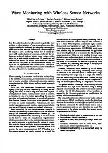
114 Figure 1
A. Rosi et al. The architectures of the Calita major deployment (see online version for colours)
3.1 The infrastructure The Calita’s sensor network infrastructure has been deployed in May 2009 and it has been at work till the following September. It exploited 13 Crossbow Micaz motes with TinyOS software and covered a surface of about 500 square metres. Nodes embedded accelerometer sensor boards for capturing slope movements and environmental boards for the monitoring of ambient parameters such as temperature, pressure, humidity and light depth. Our activity for designing and setting up the infrastructure started in November 2008 and lasted until April 2009. During that period, while being slowed down in our activity by adversarial weather conditions, we had performed several minor test deployments to experience with diverse data collection/storing algorithms, devices, boards, and to observe energy consumption and batteries duration on single mote or on portions of the entire network. Following, in May 2009, we have been able to deploy a stable infrastructure, architected as from Figure 1. Six of the available Micaz nodes have been configured as ‘Data’ nodes and three as ‘Bridge’. The six data nodes were settled on the landslide in two different active zones (i.e. prone to movements) of the landslide, as outlined by the circled groups of three motes each in Figure 1. The main task of data nodes was of sampling vibrations (via on board 2 axis accelerometer) from slope movements originated by an active landslide and of sending them to bridge nodes which, following a predetermined static routing table, forward packets to a laptop acting as a base station to collect
sensor readings. We opted for a static routing table having noticed that a dynamic routing network, during its attempt of determining the routing table, forces motes to exchange a massive amount of synchronisation packets exceedingly draining batteries. Accelerometers in the active zone sampled acceleration values at 10 Hz. Every hour they send an ‘alive packet’ with the aim of communicating their health status and batteries power consumption. The base station was linked to accelerometer sensors through a sequence of three bridge motes. Bridges were placed at an average distance of 30 metres, giving network about 90 metres of total extent. Every bridge was in charge of collecting packets coming from the associated accelerometer motes (two motes for bridge) and eventually of forwarding packets coming from more peripheral bridges. Close to the base station, and out of the active slope zone, we settled three more motes to measure atmospheric pressure, humidity, light depth, temperature and acceleration. The latter had the aim of providing an external neutral reference for the accelerometers in the active zones. The base-station mote, cable-connected to a laptop, had the task of retrieving network packets. The laptop, exploiting FTP over an UMTS connection, would send data to our servers at the university. There, a Java application elaborated data and finally stored it in an MySQL database. Retrieved data were finally processed and elaborated. Results, both aggregated and punctual, were presented via a Web 2.0 graphical user interface (see Fig. 2).
Landslide monitoring with sensor networks
115
Figure 2
A screenshot from the Calita monitoring web site (see online version for colours)
Figure 3
The four states compression algorithm: quite state, qtm state, motion state, mtq state. Red line represents collected acceleration values over x-axis, blue line the y one (see online version for colours)
116
A. Rosi et al.
3.2 Data collection algorithm From the study of sensor behaviours during early deployments, we designed an in-node compression algorithm for processing vibrations data, as measured by accelerometers on the ‘Data’ nodes, making them able to distinguish a false-positive instrumental noise from a real acceleration tickle potentially expressing a movement of the landslide surface. This has been realised by introducing four sensor states and associating to each of them a behavioural pattern. States and actions to be performed by each data node are the following (see Fig. 3): 1
Quiet state: Values collected from sensor accelerometers are aligned and included around a range of 0.2 mG (often due to sensor intrinsic error). Once an hour, during this state, each node transmits to the base station the absolute values of its relative origin axis point once an hour. Swinging values are rejected, while the radio interface remains shut down. The first slice of the graph in Figure 3 presents this state where vibration values are almost steady.
2
Quiet to motion (qtm) state: A node recognises that acceleration collected values are overtaking the swinging range. A motion is detected. The node goes in the ready state and starts recording sampled data. The second slice of the graph in Figure 3 stresses a marked variation in sampled values.
3
Motion state: Collected accelerometer information is buffered and stored into mote internal flash memory. Landslide accelerometer values are presented in the third slice of Figure 3.
4
Motion to quiet (mtq) state: A node recognises that actual acceleration values are converging to a new relative 0 mG acceleration axis centre, it means that motion has ended. The radio interface is powered on and all the previous collected data are sent to base station. Node automatically resets itself to ‘quiet state’.
Such compression over sampled data enables to drastically reduce the duty cycle of the transmission subsystem allowing to shut down node radio when node-to-base communication is not required. If by a side, this allows for batteries saving, the resultant one-way network shows evident drawbacks. The most critical one concerns the risk of network partitioning if a bridge gets stuck. Nodes are unable to self-reconfigure, and if network drops there is no way of recovering it without human intervention. Although this can represent a huge restriction (e.g. we cannot remotely reprogram mote over-the-air), it helps (together with our algorithm) minimising radio activities and prolonging batteries’ life.
3.3 Results and assessment Calita’s major deployment globally produced a monthly traffic of around 16,000 packets, corresponding to about 550 Kbytes of overall traffic per month and to an average hourly traffic of 1.8 packets of 35 bytes per node. The so-collected data, mostly related to accelerometer sensors, has been compared with data collected by a surface wire extensometer (1 metre nearby off our sensor network). The comparison has been further crossed with rainfall data over the specified time period.
Figure 4 (top) compares the ground acceleration recorded by a data node with the surface displacement measured by the wire extensometer during a representative period of 6 days. As can be seen from black arrows, the peaks of ground acceleration well agree with the peaks recorded by the wire extensometer, which indicate small landslide displacements or (more probably) near-surface vibrations caused by rainfall or wind. Considering collected data, it demonstrated the effectiveness of our four states algorithm and its skill in recognising an acceleration signal above the environmental noise. Figure 4 (bottom), besides, shows some binding between rain precipitations and slope instability, underlining that after heavy rains often slope motions will follow. Also in this case, much more correlations of this kind have been registered over the whole period. The system, however, exhibited a 30% of ‘motion states’ that does not find a correspondence on wire extensometer data. In Figure 4 (top), the second arrow from the left does not exhibit a tight relation with the extensometer and, at present, we cannot judge if the detected ‘motion state’ was real (but not recorded by the wire extensometer for some reason) or if it has to be classified as false-positive. More studies, more sensors and possibly a finer adjusting of parameters in our data collection technique can be needed to solve the problem. However, this is not the main scope here. The key message, we think we can deliver here, is that our deployment proves that WSN technologies (even in our simple, and mostly based on commercial hardware, setting) have the potential to act, if not as a radical alternative, at least as an effective complement to existing landslide monitoring technologies. In particular: •
WSNs with on-board environmental sensors and acceleration sensors could definitely represent a valuable alternative, when for security reason, the deployment of a monitoring system in a settled zone should be fast, and prompt warnings have to be forwarded on real time to rescue units (which is not possible with traditional techniques, requiring a considerable time to deploy instruments).
•
WSNs could be deployed beside strain gauges and other traditional instruments to achieve at low costs a double way of monitoring the same phenomena from two different viewpoints, with an increase in accuracy, resilience and real-time information retrieval.
•
WSNs can be connected to existing instruments not only as a monitoring tool but simply as a communication and distributed processing tool.
Furthermore, once a system for landslide monitoring has been opportunely tested and once a reliable and fine-grained algorithm for data analysis and comprehension has been developed, we envision that whole system could be pushed over the simple detection of events toward a more challenging prediction of landslides. It is obvious that the earlier a landslide is predicted, and warnings are propagated to people, the more effective precautionary measures will be taken for minimising potential damages to people and objects.
Landslide monitoring with sensor networks Figure 4
4
117
Top: a comparison between how accelerometers and strain gauges detect the same events. Bottom: a match graph between precipitation levels and slope motions. Arrows highlight correspondences between measures (see online version for colours)
Challenges and lessons learnt
Although we consider our experience quite a successful one, it has posed us several problems, both related to sensors’ inherent characteristics and to the characteristics of the target scenario. We present these problems and the lessons learnt from them in the hope that this can be of help to other researchers and engineers.
4.1 Getting wired One of the key advantages of WSNs is being wireless. However, the data collected by sensor networks must eventually flow somewhere to be made accessible and analysable, that is, towards a base station that, being typically very energy consuming, will have to be connected to the electricity network. In our case, the landslide was on a remote site, the closest house (and electricity/wired networks access) being at 300 metres distance. We have solved the issue of network access by exploiting wireless mobile access (e.g. UMTS carrier). However, we needed to provide electrical power to the laptop (which has high energy consumption due to UMTS transmission), forcing us to deploy a 300-m cable. This is a general problem for sensor networks in remote sites, and possible solutions dealing with the use of high wattage solar panels or fuel cells can be of limited applicability. In fact, our experience with them shows that the efficiency of photovoltaic tends to diminish very soon with time in such remote and wild environments (because of rain, soil slides, leaves falling from nearby trees and animals
activities), calling for frequent maintenance activities. Only for emergency alert scenarios, where a monitoring infrastructure for first response has to be set up, solar cells can be an effective solution. To sum up, we think that the problem of minimising energy consumption in sensor nodes via proper energysaving algorithms is only one of the possible energy and wiring challenges that may have to be faced in sensor network deployment. The base station will typically have to be self-powered, and either you adopt a costly solar power system, or you have to wire it to the power grid somehow, which may not be trivial. In our case beside the mere monetary costs of the cable, the safe wiring of a base station placed in the field has been very complex and timeconsuming. As a matter of fact, operations on a steep – and usually muddy – slope are generally uncomfortable and unsafe.
4.2 Ground installation and packaging As already described, our deployment (see Fig. 5) settled the base station laptop in a safe position (a non-active zone) close to the active zone of the landslide, along with some environmental sensor nodes. And that was quite an easy task. The ground installation of nodes in the active (and more interesting) zone of the landslide, instead, had to be faced carefully. Bad positioning could lead (and has lead in early deployments) to losing some sensors, either buried by mould or cut out of the network because of vegetation growing around. This may not be a problem if one has sensor nodes to waste, but this was not our case.
118 Figure 5
A. Rosi et al. On top-left a picture from the landslide region. On the top-right a deployment aerial picture. On the bottom: the sensor package and its wooden house (see online version for colours)
Even when a good positioning was found, sensor nodes were still subject to atmospheric factors and animal activities. The choice of a proper protecting packaging was not so trivial. From one side, we need to protect them from wetting (due to humidity, rain or snow), wildlife activities and surface slope processes (falling stones, soil erosion and flowing mould), while still being able to sense environmental conditions. The rain, besides, leads us to a further challenge because hitting the sensor with its drops generates false-positive vibrations making retrieved acceleration data unusable. In the end, we opted for a double package: the electronic components were wrapped by a plastic isolated package with a small hole on the bottom for pushing out condensate water and allowing environmental measures. Then, the nodes were integrally bind to two iron stakes knocked in the soil for 50 cm for sensing slope movements; finally, a wooden roof was raised over each nodes to protect them from external hurts such as rain drops and falling stones (Figure 5, bottom). In conclusion, packaging and deploying the sensors were more challenging than expected. Beside the time needed to really understand the problems at hand and the time spent in hardware stores looking for proper packages and tools, the ground installation required, for each node, around 30 minutes for properly setting up and assembling the components and further 30 minutes for placing it on the ground. When approaching the real-world deployment of WSNs, all the above procedures are typically highly underestimated. Here our advice is to carefully account them during the preliminary budgeting of costs and time. Moreover, do not grudge on the package task, remember to carefully protect the electronic components, preserving them from external elements, but without hampering sensors’ measurements. This is of crucial
importance for preserving devices integrity, allowing for being reutilised in further deployments.
4.3 Network configuration One of the main dreams we had at the beginning of our work was that of deploying sensors around without care and have them self-detect each other and self-organise in an operating data collection system. However, we had to cool down our aim at static and a-priori designed routing schema to make data collection easy to be managed and reliable. Beside the problems related to the physical characteristics of the environment (see previous subsection), this choice was also determined by the fact that any dynamic routing schema we tested was extremely energy wasting and mostly unreliable since it would have required a much more dense network than we had. The implemented static routing schema, other than being inflexible, required a lot of effort: sensors cannot be easily programmed on the fly, so routing data have to be decided and coded into sensors on site after every point-to-point link between sensors has been tested. In fact, caused by irregularities of the slope surface, nodes often resulted to be placed on different planes with stones or grass obstructing the line of sight. This situation, since the deployment phase, obviously leaded to a continuous difficulty in establishing consistent radio link between nodes making every predefined lab routing table totally useless. In addition, bookkeeping activities alone required a lot of efforts. For each deployment, it is important to record where the sensors have been placed, and which kind of devices (e.g. accelerometer and humidity) were active. Then, collected data have to be effectively sorted, compared with each other and stored in a suitable repository.
Landslide monitoring with sensor networks Figure 6
119
Left: percentage of packet loss changing antenna configuration. Right: point-to-point maximum range (in metres) (N: new antenna, S: standard antenna) (see online version for colours)
Our advice here is to adopt the KISS design principle (Keep It Simple and Stupid) and to progress step-by-step. Before experimenting more complex routing algorithms and protocols assure that your network is able to provide its basic functionalities in a reliable way. Only after a wide and longlasting testing phase, eventual improvements could be tested on field. As a note of folklore: one night, while relaxing in a trattoria after a whole day of work in Calita, we had some real fun in re-reading fragments of sensor networks articles claiming things such as ‘you can spread sensors at random even by plane and have them automatically start working and collecting data’.
4.4 Communication issues A primary goal of our work was robustness and reliability. A WSN – so they say – copes gracefully with the fault of some nodes, either if you make node and routing schemes self-adaptive or if you replicate nodes and static routing tables. Both solutions can help recovering from the network connections break down. None of which was our cases. During our deployment we have experienced several broken communication links, for very unexpected problems. Beside problems related to water infiltration and battery consumption, the biggest problem was that the antennas of our Micaz motes worked quite well on the 2D environment of our laboratory (all sensor nodes aligned on a single plane), but experienced a dramatic decrease in performance (i.e. radio range) in the 3D environment of the landslide (where there was no way to align antennas on a single plane). We decided to replace the original Crossbow Micaz antennas (reliably ensuring a 30 metres range in outdoor conditions and in a 2D aligned setting) with AeroComm homepage: http://www.lairdtech.com/ 5 dBi, 2.4 Ghz 7″ antennas on MMCX plug. New antennas enable point-to-point links to be extended over 80 metres and to drastically reduce packet loss at reduced distances. In particular, we had driven several experiments in order to test point-to-point link extension and quality in different configurations. The results are presented in Figure 6. As we can see in the first figure, the
combined use of AeroComm antennas in both receiver and sender motes permits to extend the link range up to 250%. Moreover, Figure 6 shows us the benefits in term of packet loss exploiting new antennas. The graph stresses that at a distance of 30 metres between nodes (the distance that we design to put motes each other on the landslide), the link quality considerably improves making packet loss decreasing from the 11% of the original antennas configuration to a nearly 1% of the new configuration. The antenna upgrade has raised the hardware cost, per single node, of about 30 USD. In addition, replacing out-of-the-box antennas with the new ones consisted in several hours of searching for finding appropriate antennas, in waiting a few days for having them delivered, and 2 hours or so for mounting them on the sensor nodes. All these human costs have been accounted during the budgeting phase.
4.5 Energy consumption issues A challenge more strictly related to the application context is the definition of the right trade-off between performance and node consumption. Sampling slope motions at high-rates certainly produces more accurate and meaningful data but also an even increasing traffic of packets over the network. In addition, maintaining balanced energy consumption between nodes is fundamental in order to extend the average network life. The first test we conducted shows how node energy waste varies between ideal conditions, lab tests and the on-the-field deployment. For accelerometer nodes, we tie over a scenario characterised by considerable slope motion producing up to 20 packets for node for hour (composed by false-positive and true signals and alive packets): the above condition leads to an estimated 0.5% transmit duty cycle value. Bridge motes exhibit an extremely wasting energy profile, up to 17 times more expensive than data nodes (see Fig. 7). Results give an expected lifetime of 3 days for bridge motes and nearly 90 days for data motes. Lab tests nearly confirm expected batteries consumption, motes in both configurations (data and bridge) exhibit a 23% longer lifetime: 3 days and 22 hours for bridge nodes and nearly 70 days for data node, with an average hour consumption of 1.46 ma/hr for data motes and 24 ma/hr for bridge ones.
120 Figure 7
A. Rosi et al. Left: power consumption in different situations. Right: actual mote power lifetime with different batteries (see online version for colours)
The wasteful power consumption of bridge motes (see Fig. 7, left) forced us to perform several minor operations during the monitoring phase for replacing exhausted batteries. Accordingly, reducing and balancing the energy consumption over a sensor network are main challenges to create a viable landslide monitoring application. It is clear that bridge motes, having to remain awoke 24 hours a day for all the week persistently hearing for packets sent over the air, exhibit very high hourly energy waste. Actually, we are designing to fix both problems in a definitively way. For our major deployment, we arrange the above-mentioned problem by providing bridge motes of an auxiliary power supply system composed of two couple of batteries in parallel connection. The above trick on batteries’ usage probably explains the above positive alteration on power consumption. Power consumption data from final deployment suggest us that expected life for node powered by several couples of batteries in parallel connection ensures an extended life with respect to the sum of lives expected exploiting only a couple of batteries at time (see Fig. 7, right). Beside any additional advices, the most important notion about power consumption that you have to bear in mind is that nodes perform an almost constant power consumption during transmission even varying network topology, the number of nodes or the volume of data being transmitted over the network. In fact, as other researchers (He et al., 2010) have already demonstrated, nodes’ power consumption during data transmission is almost invariant with respect to the amount of data being conveyed, instead it is the time length of radio power-on that dominates the energy consumption.
4.6 Devices heterogeneity and interoperability The deployed infrastructure was overall highly heterogeneous in terms of devices and network connections. This appears to be a general characteristic of most WSN infrastructures, typically composed of different kinds of devices ranging from micro-sensors for fine-gain readings to large backend servers to process and store-retrieved data which carry on the issue of configuring and programming over a number of technologies to set up a fully working system. For instance, in our deployment:
•
Sensor nodes are Micaz devices with TinyOS operating system, and we had to develop data collection algorithms with the nesC programming language.
•
The base station runs Linux with software, written in Java and C, that translates bridge packets from a Zigbee network to an UMTS one.
•
Backend servers have Microsoft Windows operating system, for which we had to develop software to deal with data storage and with web data organisation and presentation.
To effectively tackle such a spectrum of diversity typically requires a lot of competences and human efforts, which translates in temporal and economical costs. Commercial proposals are starting appearing proposing (nearly) ready-touse systems (e.g. the Crossbow EKO toolkit, homepage: http://www.xbow.com/) that can notably facilitate the deployment of fully-fledged sensor networks infrastructure (there included the necessary web interfaces). However, if this can make the technology affordable to people lacking of any technical background, the result is usually a closed system that lacks any configuration flexibility. In the case of our landslide scenario, they would have been mostly useless. A number of research proposals are dealing with simple yet flexible and open programming framework for sensor network infrastructures, but only a few of them are getting experienced in real-world deployment (Ceriotti et al., 2009). Thus, and while waiting for stable and usable programming frameworks, one should carefully evaluate the trade-off between flexibility (carrying on complexity) and simplicity (as from existing inflexible commercial systems).
4.7 Lack of debugging tools Debugging wireless embedded systems is very hard, especially when the network fails to operate correctly. We have experienced various faults during the deployments, such as sensor failure, reading error, packet loss and node failure. Up to now, there is not any universal diagnosis tool provided for WSNs, so if data are lost over the network flowing, or if they appear to be ‘wrong’, we can only
Landslide monitoring with sensor networks conjecture the ‘guilty’ or the causes of those faults and take attempts to correct them. This open-issue in developing WSN is often widened by the adoption of sensors that being miniaturised, and at the same time low-cost, are not free by misreads, inaccuracies or, more in general, sampling errors. LEDs on sensors nodes are one of the most useful debugging tools for WSN developers (i.e. LED lights is associated to different program states). However, it is important to switch LED off during the deployment: a single LED consumes about 3 mA. That makes a total of 9 mA for the typical three LEDs wireless node. For comparison, power-on radio consumes 15 mA. There is thus no reason to efficiently manage the radio while carelessly using the LEDs (Barrenetxea et al., 2008). Giving the lack of debugging tools, our suggestion is to perform several preliminary tests and a continuous and accurate log of the whole development process. Bookkeeping activities alone required a lot of efforts, but it can pay off. If you are stuck, records and expertise from past activities could bail you out.
4.8 Making sense of the acquired data Once all the above issues are nailed down, data eventually flow to our backend server. Still, making sense of such data and understanding if the values being collected are good is yet another challenge. Calibrating sensors is a first step to get data right. In addition, we tried to make sense of the collected data under different exemplary circumstances. What is the typical pattern in a free fall? What is the typical standing still pattern? We find that it is very difficult to maintain consistency between calibration and exemplary patterns being collected at the lab and in the field. Thus, we ended up in collecting rough data and post-processing it to calibrate to the base (standing still) pattern. Moreover, we evaluate data quality by comparing it with data coming from strain gauges deployed in the same environment (see Figure 4). In this context, long-lasting deployment can be very useful to spot unforeseen bugs in the acquired data. Here, our advice is to preserve the data from every past deployment, even if at first sight it could appear fairly useless. For example, the fact that rain drops would affect acceleration measurements is not something we were able to foresee. The bug has been identified by analysing and post-processing data to detect anomalous readings.
5
Related work
In the field of landslide monitoring, existing literature mostly relates to: (a) algorithms, (b) proposals for infrastructures and (c) on-field experiences. Works on the first category usually deal with the study and development of data analysis algorithms for landslide recognition and prevention. Ian et al. (2006), for example, develop its algorithms with the hypothesis of being exploited with buried or semi-buried sensors (not yet realised). Mehta et al. (2007) propose various distributed pattern detection algorithms for landslide prediction using WSN equipped with strain gauges. Gu et al. (2005) have proposed a schema for rare
121 events detection, but landslides, as a matter of fact, are rare events that however need a periodic high rate sampling to be caught. As relevant as they can be, these proposals mostly lack from extensive testing on a real-world scenario (which, as we show in this paper, can really challenge any assumption). As for the second category, one of the most complete and ambitious proposal is Senslide (Sheth et al., 2007), which defines a complete hardware and software architecture, integrating a variety of different sensors and data analysis algorithms for detecting and predicting landslide activity. Terzis et al. (2006) propose the interesting idea of a wireless network based on ‘sensor columns’, integrating both surface and underground sensors, as well as specifically conceived data analysis and collection algorithms. However, despite their potentials, both approaches are so far hampered by the lack of field tests to match against environment variables and realistic conditions. Works coming from field monitoring activities are definitely few, and between them only one regards landslide monitoring. Lee et al. (2008) deployed a distributed infrastructure based on a series of nodes buried into a potential debris flow body and on a set of receiver nodes on the side of the channel. This approach, however, is suitable to investigate fast landslides characterised by a well-defined down slope path (such as debris flow) and cannot be exploited to large, slow-moving landslides where the distribution of activity is much more complicated. Unfortunately, this is not the case for many of the known landslide phenomena.
6
Conclusions and future works
WSNs are potentially very useful for monitoring natural environments such as remote and isolated landslides. Several research groups (Angeli et al., 2000; Langendoen et al., 2006; Barrenetxea et al., 2008; He et al., 2010) have described the technical problems (e.g. protocols, algorithms and power optimisation) arising during the deployment of a WSN in the ideal conditions of a laboratory. Our experience remarks how difficult it is the realisation of even basic functionalities in onfield deployment. Thus, the scholarly known advantages of WSNs are still far to be easily achieved at limited (hardware and human) costs, as both our experience and those of other researchers in other monitoring scenarios confirm. Here, in this paper, we share our experiences, so that others can learn from our faults. In particular, you have not to forget that every activities performed outside of the lab could ask for double the time, beyond being uncomfortable and unsafe. Inconveniences are usually enclosed, and causes are hard to find out. Be patient, start from the base, go-ahead step-by-step, log every activities and note down your remarks, these are your only lifelines. Be careful when you account cost and time during the preliminary budgeting, they always result highly underestimated. By our side, we intend to push forward our activity to obtain increasingly accurate measurements of landslides, also by developing dedicated instruments and by improving our algorithms for distributed data analysis. Although the release of new and more efficient sensor network platforms will definitely alleviate some of the problems we have encountered, increased expectations will probably make us face brand new challenges.
122
A. Rosi et al.
Acknowledgements The work is supported by the Italian MIUR under the project PRIN 2007 ‘Wireless and Airborne Monitoring of Landslide Phenomena’.
References Angeli, M-G., Pasuto, A. and Silvano, S. (2000) ‘A critical review of landslide monitoring experiences’, Engineering Geology, Vol. 55, No. 3, pp.133–147. Barrenetxea, G., Ingelrest, F., Schaefer, G. and Vetterli, M. (2008) ‘The hitchhiker’s guide to successful wireless sensor network deployments’, Proceedings of the 6th ACM Conference on Embedded Network Sensor Systems, SenSys ’08, ACM, New York, NY, USA, pp.43–56. Bonanno, C., Magnani, M., Lapini, M. and Piantelli, E. (2007) ‘Landslide monitoring system based on integrated automatic total station and GPS’, Geoitalia, Vol. 2, p.221. Ceriotti, M., Mottola, L., Picco, G.P., Murphy, A.L., Guna, S., Corra, M., Pozzi, M., Zonta, D. and Zanon, P. (2009) ‘Monitoring heritage buildings with wireless sensor networks: the torre aquila deployment’, Proceedings of the 2009 International Conference on Information Processing in Sensor Networks, IPSN ’09, IEEE Computer Society, Washington, DC, USA pp.277–288. Cho, C., Chou, P., Chung, Y., King, C., Tsai, M., Lee, B. and Chou, T. (2008) ‘Wireless sensor networks for debris flow observation’, Paper presented at The 5th Annual IEEE Communications Society Conference on Sensor, Mesh and Ad Hoc Communications and Networks, SECON ’08, 16–20 June, San Francisco, CA, USA, pp.615–617. Chong, C., Kumar, S.P. and Member, S. (2003) ‘Sensor networks: evolution, opportunities, and challenges’, Proceedings of the IEEE, Vol. 91, pp.1247–1256. Corsini, A., Borgatti, L., Coren, F. and Vellico, M. (2007) ‘Use of multitemporal airborne lidar surveys to analyse post-failure behaviour of earth slides’, Canadian Journal of Remote Sensing, Vol. 33, No. 2, pp.116–120. Estrin, D., Culler, D., Pister, K. and Sukhatme, G. (2002) ‘Connecting the physical world with pervasive networks’, Pervasive Computing, IEEE, Vol. 1, No. 1, 59–69. Farina, P., Colombo, D., Fumagalli, A., Marks, F. and Moretti, S. (2007) ‘Permanent scatterers for landslide investigations: outcomes from the ESA-SLAM project’, Engineering Geology, Vol. 88, Nos. 3/4, pp.200–217. Gu, L., Jia, D., Vicaire, P., Yan, T., Luo, L., Tirumala, A., Cao, Q., He, T., Stankovic, J.A., Abdelzaher, T. and Krogh, B.H. (2005) ‘Lightweight detection and classification for wireless sensor networks in realistic environments’, Proceedings of the 3rd international conference on Embedded networked sensor systems, SenSys ’05, ACM, New York, NY, USA, pp.205–217.
He, Y., Mo, L. and Liu, Y. (2010) ‘MobiCom 2009 Poster: Why Are Long-Term Large-Scale Wireless Sensor Networks Difficult? Early Experience with GreenOrbs’, ACM SIGMOBILE Mobile Computing and Communications Review (MC2R). Highland, L. and USGS. (2004) Landslide Types and Processes, U.S. Geological Survey, Reston, VA. Ian, R.C., Akyildiz, I.F. and Stuntebeck, E. P. (2006) ‘Wireless underground sensor networks’, Ad Hoc Networks, Vol. 4, pp.669–686. Langendoen, K., Baggio, A. and Visser, O. (2006) ‘Murphy loves potatoes: experiences from a pilot sensor network deployment in precision agriculture’, Proceedings of 20th International Conference on Parallel and Distributed Processing Symposium, IPDPS 2006, 25–29 April, Rhodes Island, Greece, p.8. Lee, H-C., Liu, C-J., Yang, J., Huang, J-T., Fang, Y-M., Lee, B-J. and King, C-T. (2008) ‘Using mobile wireless sensors for insitu tracking of debris flows’, Proceedings of the 6th ACM Conference on Embedded Network Sensor Systems, SenSys ’08, ACM, New York, NY, USA, pp.407–408. Martinez, K., Ong, R. and Hart, J. (2004) ‘Glacsweb: a sensor network for hostile environments’, Proceedings of the First IEEE Communications Society Conference on Sensor and Ad Hoc Communications and Networks, October, Santa Clara, CA, USA. Mehta, P., Chander, D., Shahim, M., Tejaswi, K., Merchant, S. and Desai, U. (2007) ‘Distributed detection for landslide prediction using wireless sensor network’, Proceedings of the First International Global Information Infrastructure Symposium, 2007. GIIS 2007, 2–6 July, Marrakech, Morocco, pp.195–198. Ohbayashi, R., Nakajima, Y., Nishikado, H. and Takayama, S. (2008) ‘Monitoring system for landslide disaster by wireless sensing node network’, Proceedings of SICE Annual Conference, 20–22 August, Tokyo, Japan, pp.1704–1710. Rosenberg, L.I. (2007) ‘Landslide hazard and risk’, Environmental and Engineering Geoscience, Vol. 13, No. 1, pp.80–81. Sheth, A., Thekkath, C.A., Mehta, P., Tejaswi, K., Parekh, C., Singh, T.N. and Desai, U.B. (2007) ‘Senslide: a distributed landslide prediction system’, SIGOPS Operating Systems Review, Vol. 41, pp.75–87. Terzis, A., Anandarajah, A., Moore, K. and Wang, I-J. (2006) ‘Slip surface localization in wireless sensor networks for landslide prediction’, Proceedings of the 5th International Conference on Information Processing in Sensor Networks, IPSN ’06, ACM, New York, NY, USA, pp.109–116. Werner-Allen, G., Lorincz, K., Welsh, M., Marcillo, O., Johnson, J., Ruiz, M. and Lees, J. (2006) ‘Deploying a wireless sensor network on an active volcano’, IEEE Internet Computing, Vol. 10, pp.18–25. Xu, M., Song, W-Z., Huang, R., Peng, Y., Shirazi, B., Lahusen, R., Kiely, A., Peterson, N., Ma, A., Anusuya-Rangappa, L., Miceli, M. and McBride, D. (2009) ‘Design of smart sensing components for volcano monitoring’, Pervasive and Mobile Computing, Vol. 5, No. 5, pp.639–653.